Hopewell Culture National Historic Park, Ohio

Map showing the landscape around Fort Ancient and the Little Miami River Valley 
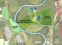
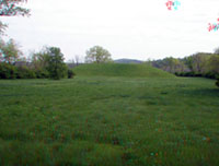
Hopewell Culture National Historic Park encompasses prehistoric American Indian ceremonial earthworks that were constructed starting about 2200 years ago. In 1923, Mound City Group National Monument was established to restore and protect ancient Hopewell culture ceremonial and burial grounds. In 1992, the park's name was changed to Hopewell Culture National Historical Park, and the park has expanded to include six noncontiguous sites near Chillicothe, Ohio including the Mound City Group, Hopeton Earthworks, Hopewell Mound Group, High Banks Works, Spruce Hill Earthworks, and Seip Earthworks. Click here to see a National Park Service webiste about these sites.
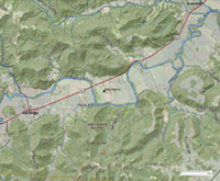
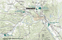
Map of Hopewell Culture NHP: Click here or on the map to see a larger view.
Click here to see a larger scale map of Ohio showing the location of Hopewell Culture NHP.
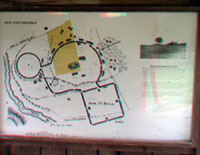
Click on any image for a larger view.

Next Image Return to Main Page
Click on the "next image" button or the map above to start an image tour of this website.
Below is a thumbnail image gallery that links to pages with images and discussion topics.

Mound City Group

Map showing the landscape around Fort Ancient and the Little Miami River Valley Mound City Group is located on a river terrace on the west bank of the Scioto River on the north side of Chillicothe, Ohio. The Mound City Group earthworks consist of a earthen border wall that surrounds 13 acres of ceremonial grounds and at least 23 mounds. There are additional mounds outside of the enclosure. The Hopeton Earthworks site is located on the opposite (east side) of the nearby Scioto River. Prior to becoming Mound City Group National Monument, site was used as an army training facility during WW1. Mound City Group is the only fully restored Hopewell earthworks complex. Mound City Group is now a unit within Hopewell Culture National Historical Park and hosts the park's visitor center.
Map of Mound City Group and Hopeton Earthworks: Click here or on the map to see a larger view.

3D Photo Gallery
Switch to Standard Photo Gallery
Trail leading to the ceremonial grounds with burial mounds. Map of the Mound City Group portion of the park. One of the straight border wall at the Mound City Group. Earthworks at the Mound City Group.
An earthen border wall. Park trail along earthworks Border wall with mounds Restored ceremonial grounds
Description of Fort Sherman Spring wildflowers May apples on earthworks Scioto River Trail
Scioto River Trail Banks of the Scioto River Banks of the Scioto River Scioto River view
Description of Hopeton area Hopeton river banks Necropolis burial mounds Mound City Group fields
Redbud trees blooming Redbud along park trail Earthen border wall & mounds Border wall and forest

Seip Mound State Memorial Park

Map showing the landscape around Fort Ancient and the Little Miami River Valley Seip Mound State Memorial Park is located in fields of the floodplain of Paint Creek, a tributary of the Scioto River and located about 25 miles east of Chillicothe, Ohio on U.S. Highway 50. Native Americans belonging to the Hopewell tradition constructed this mound sometime between 100 B.C. – A.D. 400.

Seip Mound State Memorial Park is one of six noncontiguous sites that make up the Hopewell Culture National Historical Park.
Map of Seip Mound State Memorial Park, Ohio: Click here or on the map to see a larger view.
Click on any image for a larger view, or click here to start an image tour.

3D Photo Gallery
Switch to Standard Photo Gallery
Seip Mound State Memorial park earthworks Interpretive sign at Seip Mound Burial mound at the center of Seip Mound earthworks. Interpretive sign with a historic map of the Seip Mound interpretive site.
Gap in the earthworks wall surrounding Seip Mound. An interpretive sign describing the archaeology of the site. A large burial mound located in the center of the earthworks. Map of a the Seip Mound site on a park display.
Next Image Return to Main Page