
Chapter 12 - Streams, Rivers, and Water Underground |
| This chapter is about the impact of flowing water on the surface and underground. Flowing water is a primary force affecting changes to the landscape. Understanding how water interacts with the landscape and materials underground are essential to managing water resources and protection of people and property from the effects of floods, droughts, and water contamination. The Hydrologic Cycle diagram (Figure 12-1) illustrates the circulation of water among the hydrosphere, atmosphere, solid Earth, and the biosphere. Primary processes involve evaporation (producing water vapor), condensation (clouds), and precipitation (as rain, snow, and ice). One on the ground, melting ice and rain either evaporates, soaks into the ground, is absorbed by plants. Some of it runs off (into streams), or sinks into the ground (becoming groundwater). Water in streams or underground moves under the influence of gravity, ultimately flowing into the oceans, or is trapped in inland lakes and arid basins. Humans now influence the flow of water in large regions of the world, profoundly impacting the environment. |
Click on thumbnail image for a larger view. |
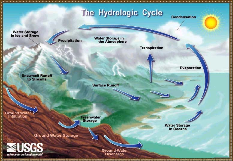 Fig. 12-1. The Hydrologic Cycle (or Water Cycle) |
Hydrology and GeohydrologyHydrology is the science concerned with the properties of the earth's water, especially its movement in relation to the land's surface. The study of water underground (called groundwater) is geohydrology. Water can sink into the ground and rise again to the surface over and over again as it flows from its source areas in upland regions to where it flows into the sea.The Hydrosphere encompasses all the waters on the Earth's surface, such as oceans, lakes, rivers, and streams. Earth's oceans cover about 70% of the surface and contains 97.25% of the water. It also includes ice (glaciers are discussed in Chapter 12). The table below illustrates where water occurs on Earth.
Atmospheric Interactions in the Hydrologic Cycle include:Evaporation is the physical conversion of a liquid into a vapor (as in water to water vapor dissolved into the air).Transpiration is the process by which water in plants is transferred as water vapor to the atmosphere. Condensation is the conversion of atmospheric water vapor into liquid water or ice (causing precipitation). Precipitation, in meteorology usage, means rain, snow, sleet, or hail that falls to the ground. (In chemistry usage, precipitation means the action or process of precipitating a substance from a solution, such as salt precipitating from evaporating seawater.) Evaporation and transpiration add water moisture to the air, condensation and precipitation remove moisture from the air. Rainshadow effect occurs on the leeward (downwind) side of a mountain range (or high volcanoes), Mountain ranges partially blocks the flow of moist air, forcing precipitation on the prevailing windward (downwind) side, and creates more arid conditions on the downwind side. Rainshadow effects are illustrated in Figures 12-2 and 12-3 for the state of California. Rainshadow effects are well illustrated on the Hawaiian Islands where prevailing winds from one direction result in wet conditions on the windward side of the volcanic islands and arid conditions on the leeward sides. |
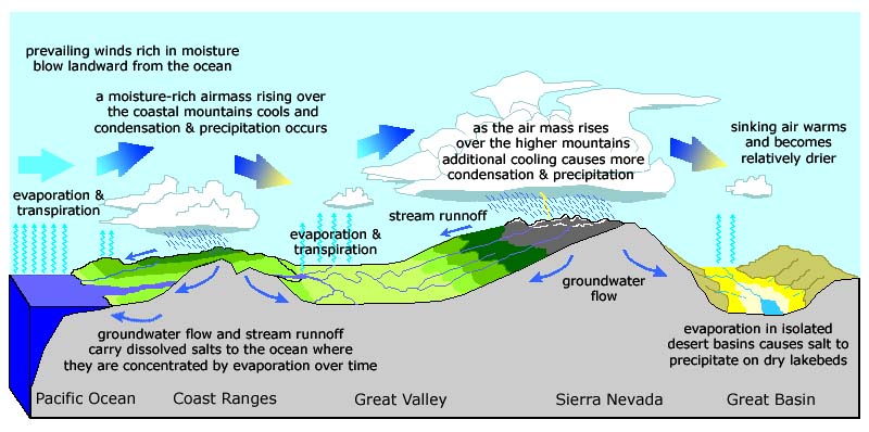 Fig. 12-2. California landscape and weather patterns influence precipitation (compare with map below). 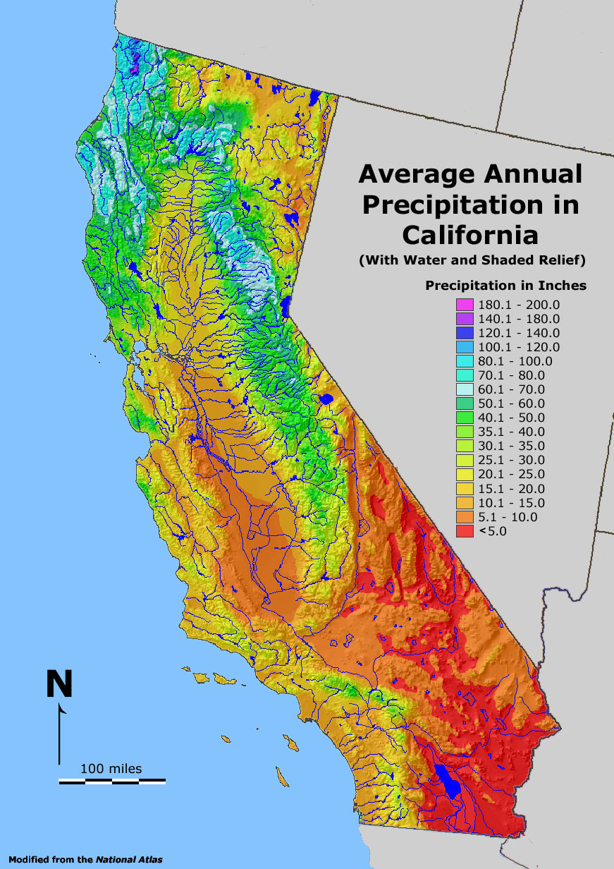 Fig. 12-3. Map of California's landscape (topography) with annual precipitation and major streams. Most of the very arid regions are rainshadow regions on the downwind side of mountain ranges. Prevailing winds in California move storms off the Pacific Ocean and precipitation falls mostly on the windward side of the coastal ranges and the Sierra Nevada range, and arid conditions persist on the leeward side of mountain ranges. Fig. 12-3. Map of California's landscape (topography) with annual precipitation and major streams. Most of the very arid regions are rainshadow regions on the downwind side of mountain ranges. Prevailing winds in California move storms off the Pacific Ocean and precipitation falls mostly on the windward side of the coastal ranges and the Sierra Nevada range, and arid conditions persist on the leeward side of mountain ranges. |
Comparison of Freshwater to SeawaterFreshwater is a general term for water that does not contain significant amounts of salt. Freshwater collected directly from rain and snow melt contains traces of salts derived from evaporating seawater, atmospheric dust, and pollution. Water in streams, ponds, lakes, and rivers are generally considered freshwater, although some inland lakes and stream in isolated desert basins can be even saltier than seawater. The natural weathering of rocks and soils contributes salts to freshwater. Most rivers pick up increasing amount of salt along their route to the sea. Through geologic time, salts derived from land contribute to the saltiness of sea water, and the salt is concentrated by the evaporation of seawater. Large quantities of salts in seawater are absorbed by saturated sediments and crustal rocks on the seafloor, which, in turn, are subducted and eventually return to be a part of the lithosphere. |
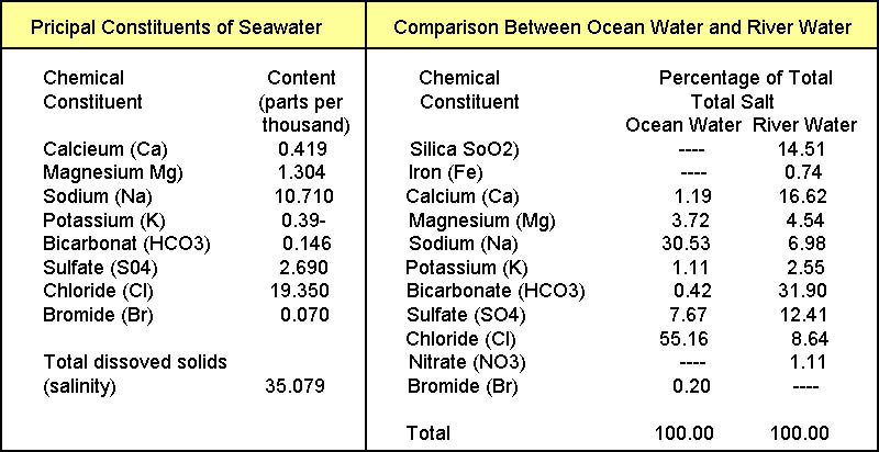 Fig. 12-4. Composition of dissolved components in seawater and freshwater in streams |
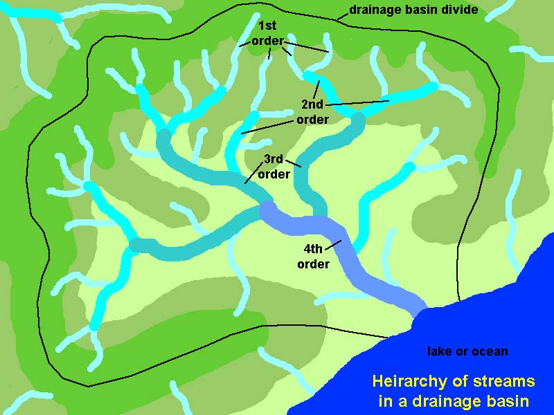
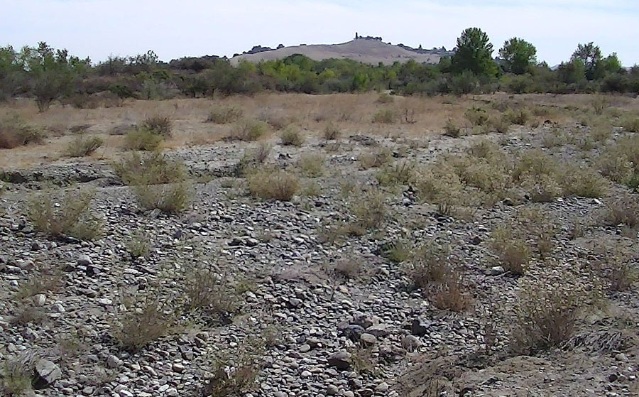
What’s the difference between a stream and a river?A stream is a small flow of water in a channel or bed, whereas a river is a collection of many streams. Other names for a stream include a brook, creek, rivulet, or small river.There have been various ways to classify rivers and streams. One method called the Strahler Stream Order (Arthur Strahler, 1957) divides streams in a hierarchy similar to branches on a tree, with 1st order streams akin to twigs on branches, and the highest order being the trunk of a tree (Figure 12-5). Most 1st order streams are in the headwater regions of a drainage basin. Where 1st order steams combine they become 2nd order streams. Where 2nd order streams merge they become 3rd order streams. 3rd order streams merge to form 4th order, and so on. However, lower order streams merging with a higher order stream do not change the order the higher stream (Figure 12-6 and 12-9). The progression size continues until a river begins at the confluence of principle stream tributaries. A tributary is a stream that discharges into a larger river or lake; the location where they merge is called a confluence (Figure 12-10.). The index of a stream or river may range from 1st order (having no tributaries) to large orders, with examples the Ohio River being a 8th order that discharges into the Mississippi River, a 10th order. The world's largest river, the Amazon, is a 12th order stream. To qualify as a hydrological feature called a stream the water flow must be perennial (meaning flows year round) or recurring (meaning it flows for at least part of a year). For instance, many streams in drier regions of the western United States only flow during wet periods such as in the spring after snow melts, or after periods of summer monsoonal rains. During drought periods, some streams may not flow for years. Both rivers and streams are bodies of flowing water, however, in general, rivers are larger, deeper, and longer than streams. A simplest definition might be that you can wade across a stream, but you would have to swim across a river. However, by this definition many streams become rivers during periods of flood, and rivers turn into streams during dry periods. |
||||||||
|

The World's Largest Rivers
|
||||||||||||||||||||||||||||||||||||||||||||||||||||||||||||||||||||||||||||||||||||||||||||||||||||||||||||||||||||||||||||||||||||||||||||||||||||||||||||||||||
Geographic Factors That Control the Flow of WaterGravity pulls water down slope. If it flows on the surface as runoff, or underground as groundwater. Groundwater discharges into streams even during periods when precipitation is not providing runoff.A drainage basin is a region drained by a principle stream (a river) extending from upland headwater regions down to where the stream merges with another body of water (a larger stream or river, lake, or ocean). A watershed is an area of land that all precipitation drains into a small stream that discharges into a lake or reservoir, a wetland, or any point along a larger stream or river channel, or bay along a shoreline. The terms drainage basin and watershed are sometimes used interchangeably, however, there may be many watersheds within a greater drainage basin. A drainage divide is a line that marks the boundary between two drainage basins, and usually follows a ridgeline or crests of upland hills. Stream flow is the amount of water moving downstream. The measure of the amount of water associated with a stream or river is called discharge. Stream discharge is the volume of water to pass a given point on a stream bank per unit of time, usually expressed in cubic meters of water per second. The discharge is measured by cross sectional volume of the channel times the velocity of moving water and sediment in the water and along the bottom of the stream bed. [Learn about: How streamflow is measured (USGS).] A flood is an overflowing of a large amount of water beyond its normal confines—inundating areas that are typically dry at least part of the year). Floods are linked to seasonal precipitation patterns (such as monsoons or spring snow melt) or catastrophic events (such as intense rainstorms, collapse of natural or man-made dams or levees). During a flood, a large amount of sediment can be transported as part of the stream flow. |
Stream Profile and Stream GradientIn most cases, the profile of a river drainage usually decreases gradually downstream. 1st, 2nd, and 3rd order stream have a high stream gradient and are fast-flowing and characterized by rapids and waterfalls. As rivers descend out of mountainous regions, the streams slow down and grow deeper and wider, and their channels gradually move back and forth across and ever-widening floodplain. Large quantities of groundwater move into and out of sediments on floodplains and tend to stabilize water flow in the lower river basins (such as along the Mississippi River downstream of Memphis where the floodplain is many miles wide; see Figure 12-11).A stream gradient is the grade (slope) measured by the ratio of drop in a stream per unit distance, usually expressed as feet per mile or meters per kilometer (Figure 12-13). |
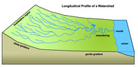 Fig. 12-13. Profile of a river drainage. The stream gradient for most rivers decreases downstream. |
How Do Streams Transport and Deposit Sediments?The shape of a stream channel also influences how fast water can move (its velocity), which directly influences how much sediment is transported (Figure 12-14).Several factors control the amount of sediment that can be carried by a stream: 1) volume of stream flow, 2) the stream gradient, 3) shape of the stream channel, and 4) kinds and volume of sediments available for erosion in a drainage basin. During floods, the volume and rate of stream flow increases, and erosion along the stream bed mobilizes sediments that accumulate during times of decreasing stream flow. Figures 12-15 and 12-16 illustrate the difference of sediment suspended in stream waters during non-flood and flood conditions. During non-flood conditions, the water is clear because streams are fed mostly by groundwater seeping into the stream channel. During floods, the water is unclear because runoff from storms erode sediment and carry it into the stream channels. Erosion carves the sides of stream channels, contributing sediments to streams and allowing the channel to migrate over time. Turbulence in the often violent or unsteady movement and mixing of air or water, or of some other fluid. Turbulence is a most important factor influencing sediment transport in a stream. Stream capacity is a measure of the total amount of sediment that a stream can carry, including the mass of solids and dissolved content. Sediments are moved by streams in different ways (Figure 12-17). Fine grained particles and dissolved components are carried in suspension (called the suspended load). With increasing turbulence, the suspended load increases. Particles that are too heavy to be carried in suspension roll, bounce, and hop along the stream bed; this process is called saltation. This moving mass of solid material is called the bed load. During floods it is often possible to hear the roar created by rocks cracking and bouncing into each other as they tumble along the stream bed. The shape of a stream channel and the stream gradient controls the amount of sediment that can be transported down stream. In straight channels, stream water moves as laminar parallel vectors, but with increasing speed and when objects hinder flow, the water becomes turbulent, constantly mixing. With increasing speed and turbulence stream water can carry more sediment (and larger particles) is suspension and as bedload. |
 Fig. 12-14. Cross sections of straight stream channels showing how the shape of the channel effects stream flow capacity and velocity. 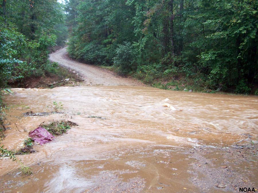 Fig. 12-16. Floodwaters are brown because they contain high concentrations of fine-grained sediments carried in suspension. |
 Fig. 12-15. A gravel bar along a mountain stream. Large boulders and gravel moves in times of flood. 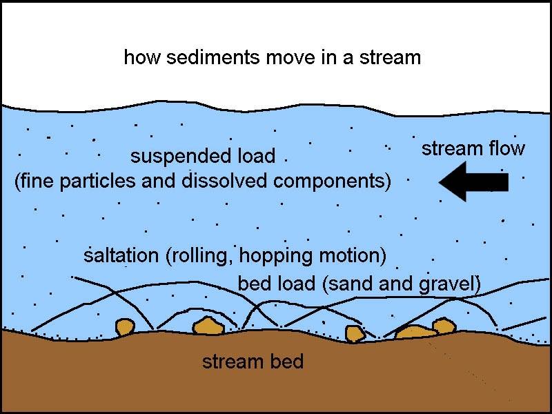 Fig. 12-17. Turbulent stream flow transports sediments by suspension (including dissolved materials and fine sediments). Coarser sediments roll, bounce, and hop along the stream bed in a process called saltation. This is called bed load. |
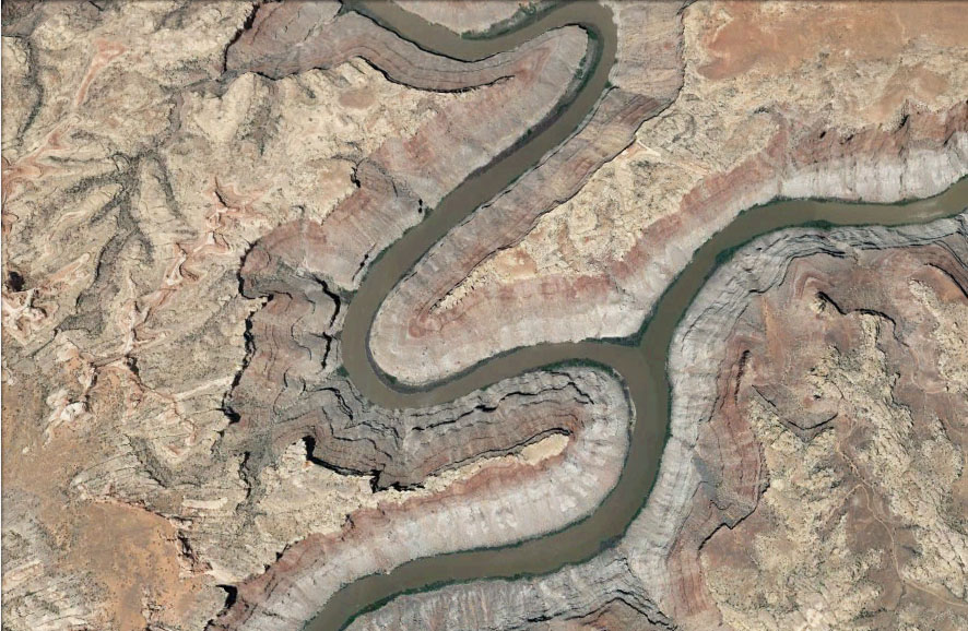
Meandering Creates Winding River ChannelsA meander is a bend in a sinuous watercourse. Meandering is the process when the faster-moving water in a river erodes the outer banks and widens its valley, and the slower-moving water on the inner side of the bend becomes a place where sediments are deposited (point bars). As a result, rivers tend to constantly change their course over a floodplain over time (Figures 12-18 and 12-19).An oxbow is a crescent lake on a stream floodplain formed when a meandering stream channel is cut off and isolated by changes in a stream channel. |
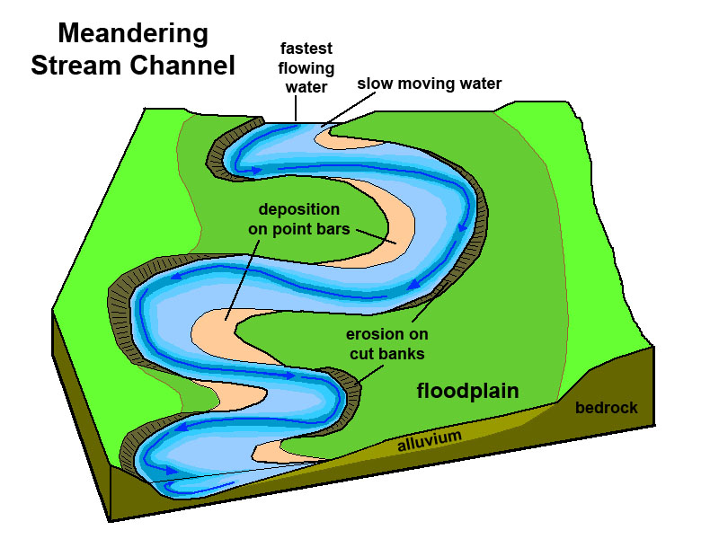 Fig. 12-18. Stream channel flow results in meandering forming cut banks and point bars (see Fig. 12-20 below). |
 Fig. 12-19. Example of a meandering river channel with cutoff channels and oxbows. |
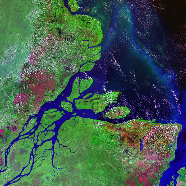
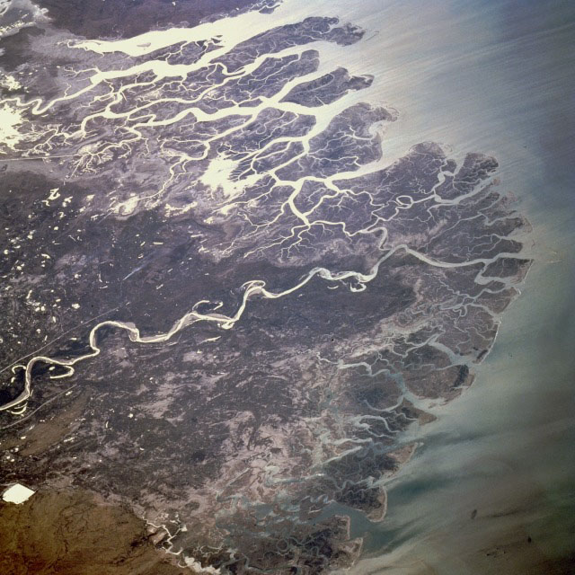
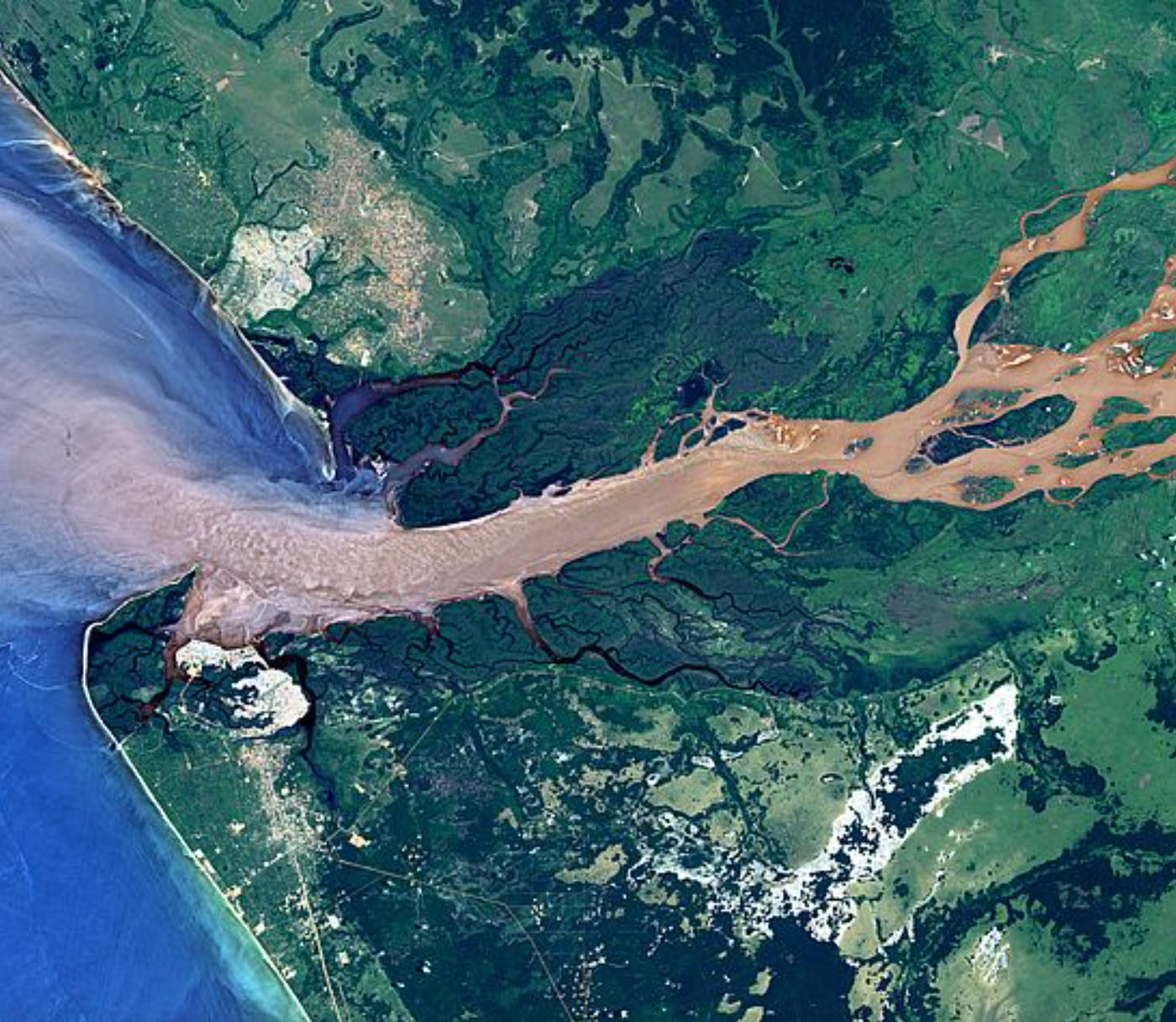
Parts Of A River SystemThe headwaters is the source region of primary precipitation catchment, including snow melt and other surface runoff, and groundwater discharge from springs. A precipitation falls (and melts) the water move downslope, collecting into a more cohesive flow. Over time, this flow carves gullies. A gully is a water-worn ravine or trench-like depression where water runs off the a hilly or mountainous landscape, caused by erosion. A tributary is a stream that flows into another stream or river (rather than a lake or sea). Tributaries combine to be a part of a larger drainage basin. Landscape features associated with a river are illustrated on Figure 12-21.The river channel is the path of a river; the size and shape of a channel depends on the volume of water flowing in it, the gradient of the stream, and the nature of rock and sediments exposed in the river bed. Parts of river valleys where the stream gradient diminishes, instead of carving downward into the river bed, stream meander back and forth, broadening the valley at the expense of the hillsides along the drainage, allowing floodplains to develop. A floodplain is a flat, low-lying area along a river that gets covered with water when the river floods, overflowing its natural levee. Slow moving storm water drops fresh sediment on floodplains. The riverbank is land immediately exposed along a river during non-flood conditions, but sculpted by flowing water during high water conditions. River banks can include cutbanks (stream-cut exposures of bedrock and older stream sediments) gravel bars and point bars (Figure 12-22). When floodwaters spread out onto a floodplain, they slow down, depositing sediments along the outer margins of a stream channel, resulting in the build up of natural levees. Many river floodplains have wetlands. Wetlands are lowland areas where water covers the surface, at least part of the year. Also called swamps, marshes, or bogs. Wetlands provide habitat to many varieties of plants and animals. A splay is a small fan-shaped or outspread alluvial deposit formed where an overloaded stream breaks through a levee (artificial or natural) and deposits its material (often coarse-grained) on the floodplain (Figure 12-23). Like meandering, the formation of splays contributes sediments to flood plains, particularly during times of flood. A delta is an accumulation of sediments at the mouth of a river that may consist of a network of distributary channels, wetlands, bars, tidal flats, natural levees and beaches that typically shift from on location to another. Delta shape is dependent of dominant current conditions where the mouth of the river: tide-, sea wave-, and storm-dominated. A distributary is the opposite of a tributary. A distributary channel is a stream that branches off and flows away from a main stream channel. Distributaries are common features on river deltas where slowing water and interaction of ocean tides, waves, and currents influence the distribution of sediments along a coastline. Distributaries can form along floodplains near the mouths of streams entering larger rivers or lakes. |
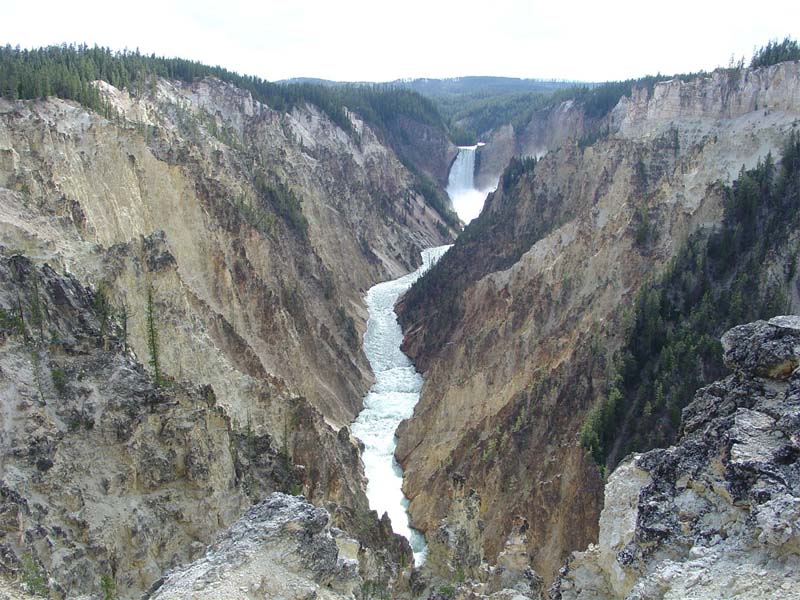 Fig. 12-20. Waterfalls and rapids are common features in headwater regions. Upland stream and river valleys typical have a V-shape. 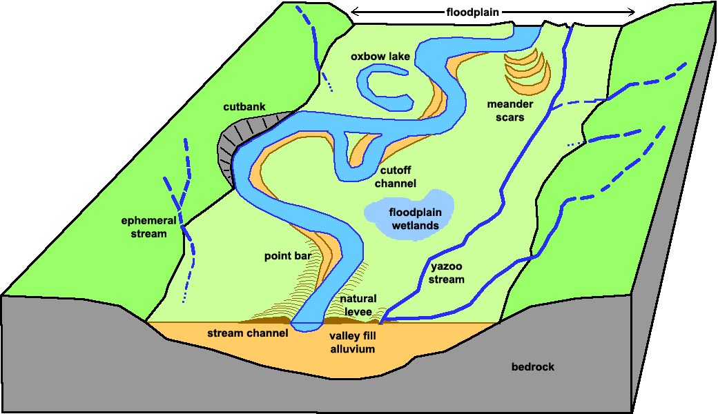 Fig. 12-21. River features 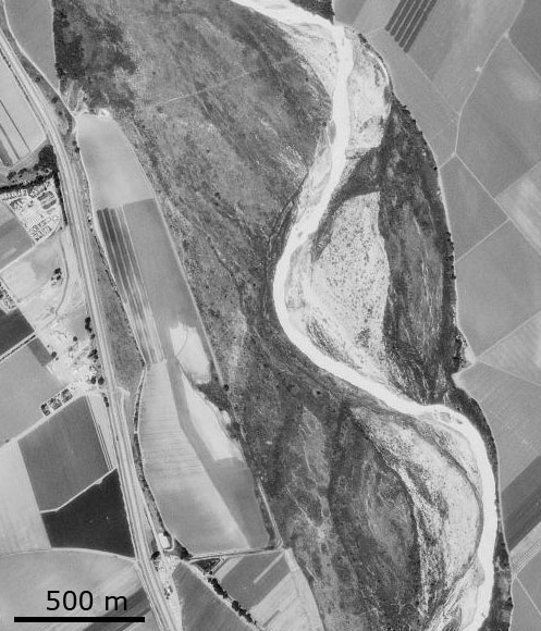 Figure 12-22. Point bars (gravel bars) along the Salinas River in Monterey County, California. 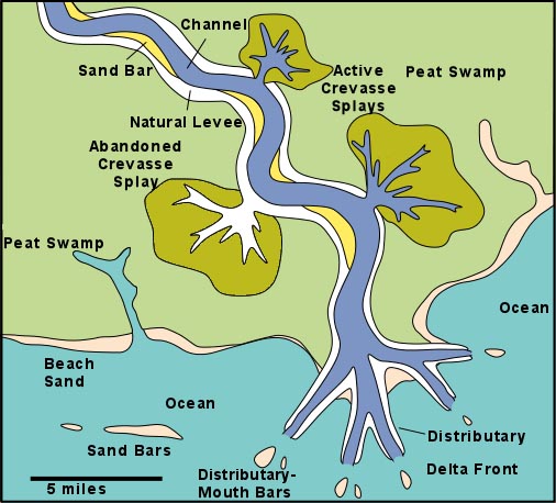 Fig. 12-23. Splays and distributary channels on a river delta. |
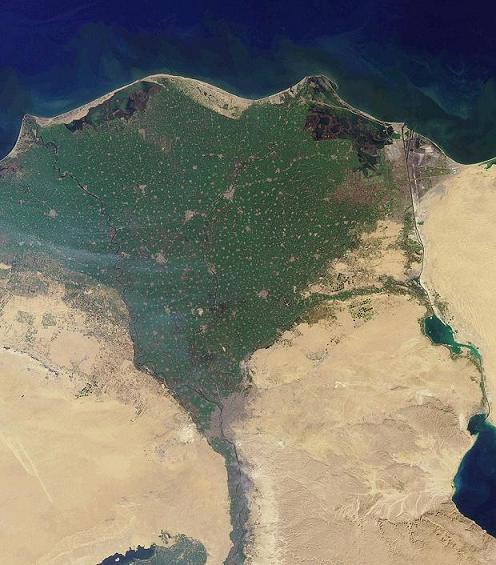
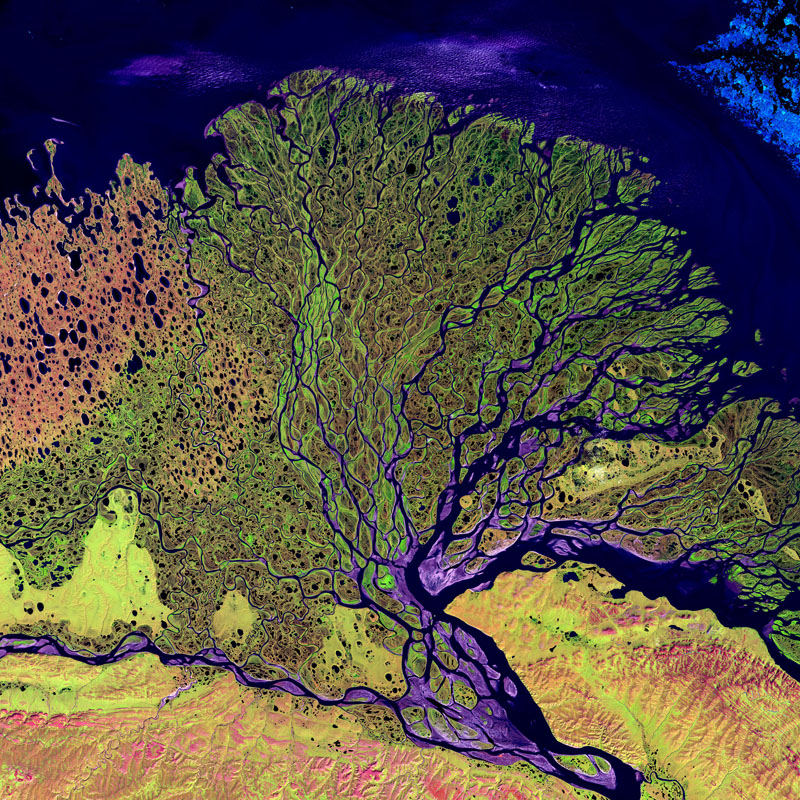
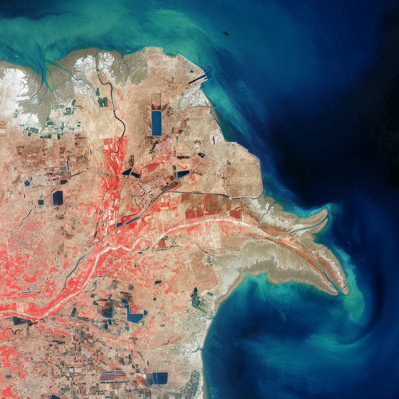
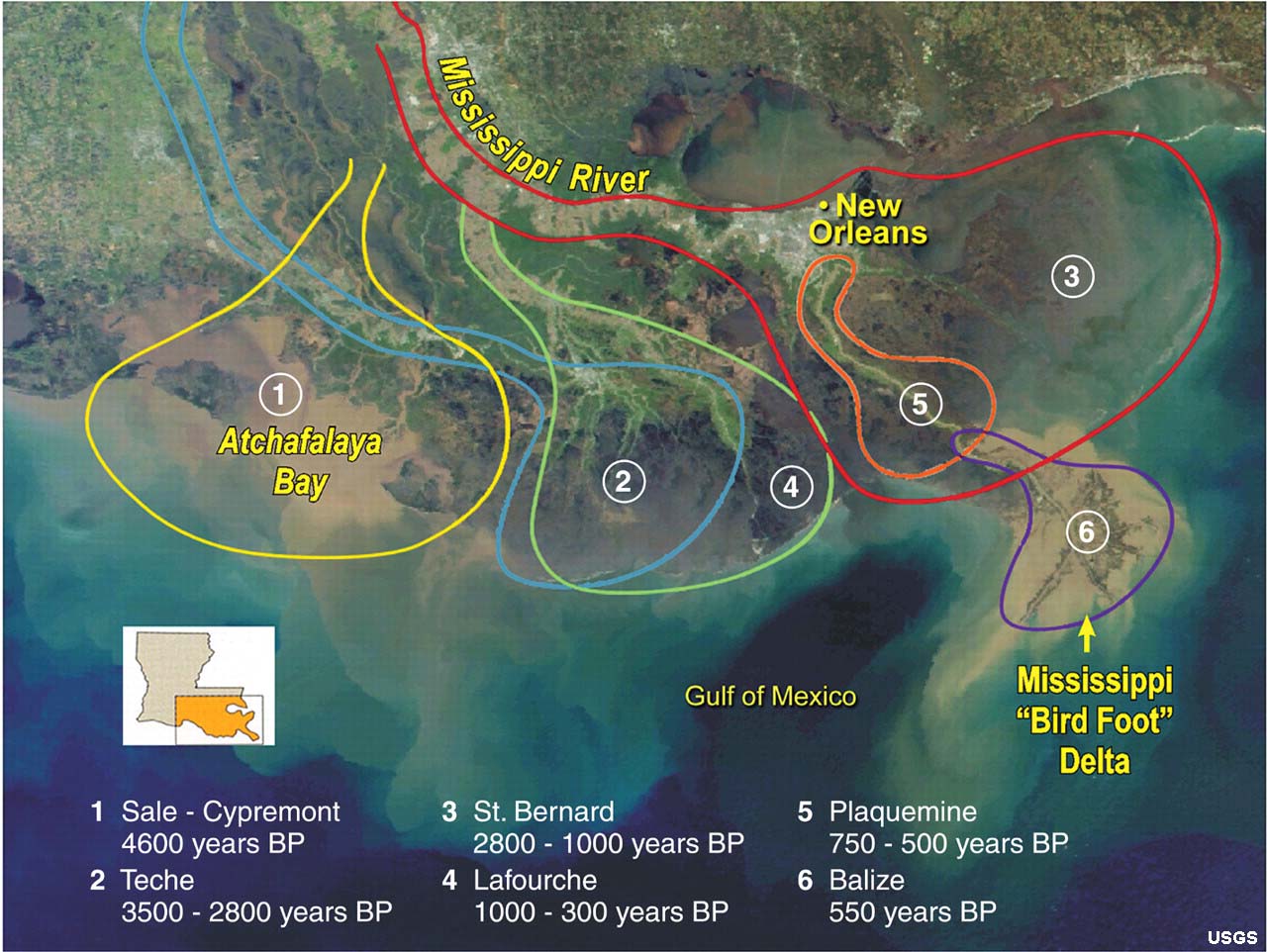
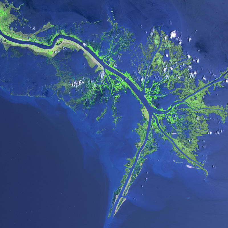
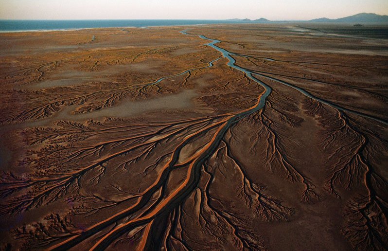
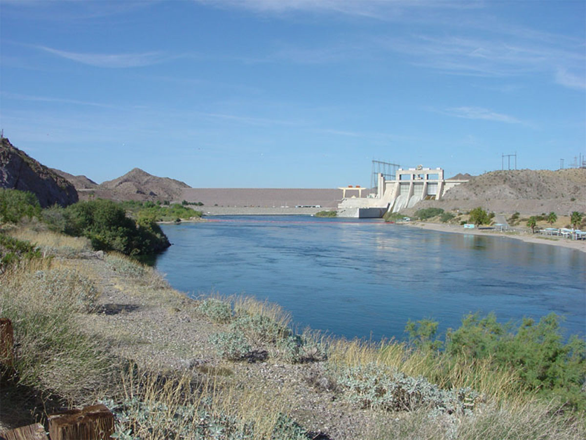
Examples of River DeltasRiver deltas around the world are very different. The shape of a river delta is controlled by a variety of factors including:• the volume of river discharge. • the volume of sediment being deposited in a delta region. • vegetation cover in delta regions capable of trapping sediments. • tidal range conditions where the river enters the ocean. • storm-related climate and oceanographic conditions. • coastal geography (mountains or plains) in coastal regions. • human activity is now a dominant factor influencing the shape of river deltas. River deltas like the Amazon and Indus Rivers discharge into the ocean where a high tidal range influence flow into and out of the mouth of the rivers. Some river delta region are highly effected by erosion effects of storms and high wave energy. Infrequent but intense superstorms impact the shape of deltas and shoreline, such as the impact of hurricanes on the Gulf Coast. Human activity is responsible for the irregular shape of the Birdfoot Delta on the Mississippi River created by the constant dredging to keep shipping channels clear (Figure 12-30). The construction of dams and diversion of water out of the Colorado River has essentially shut of the supply of water and sediment to the Colorado River Delta in the Gulf of California (Figure 12-31). |
||||||||||||||||
|
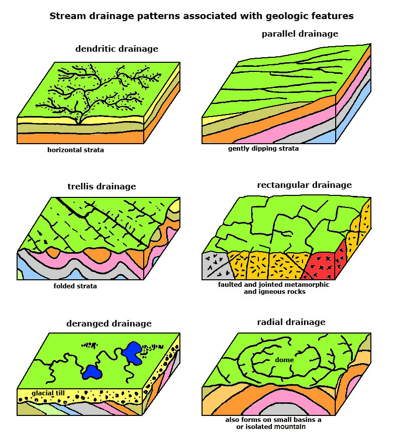
Types of Drainage Networks and Drainage PatternsA drainage pattern is a pattern created by stream erosion over time that reveals characteristics of the kind of rocks and geologic structures in a landscape region drained by streams (Figure 12-31).Dendritic drainage patterns are randomly shaped systems that commonly form on heterogeneous bedrock, such as flat-lying sediments or sedimentary rocks where there is nothing to influence the flow of water. Parallel drainage patterns develop on inclined surfaces such as gently dipping strata. Trellis drainage patterns are common in terrain with folded bedding (parallel series of anticlines and synclines). Rectangular drainage patterns are common in fractured and faulted hard bedrock (such as in granite or other igneous and metamorphic rocks). Deranged drainage patterns occur in areas that geologic events have disrupted the landscape. Example of deranged drainages occur in recently glaciated landscapes and in active volcanic regions. Radial drainage patterns are associated with circular-shaped basins and domes. |
|
Sediment Supply vs. Stream GradientA river or stream is rarely in a state of equilibrium when it comes to erosion and deposition processes. In general, upland regions receive the greatest amount of precipitation, and are places where sediments are being generated. If tectonic forces are causing the land to rise, stream gradients increase, and streams carve deeper into their valleys, forming canyons (Figure 12-33).Where streams loose their gradient, they slow down and sediments are deposited, filling in their valleys. Braided streams are common in landscapes where stream valleys are overloaded with sediment. Streams dropping their sediments are filling their channels, causing the channels to constantly migrate across a floodplain (Figure 12-34). Changes in climate can cause changes in the amount of sediments contributed to a stream flood plain. |
 Fig. 12-33. Colorado River in the Grand Canyon, Arizona. Canyons form where stream erosion dominates over deposition. |
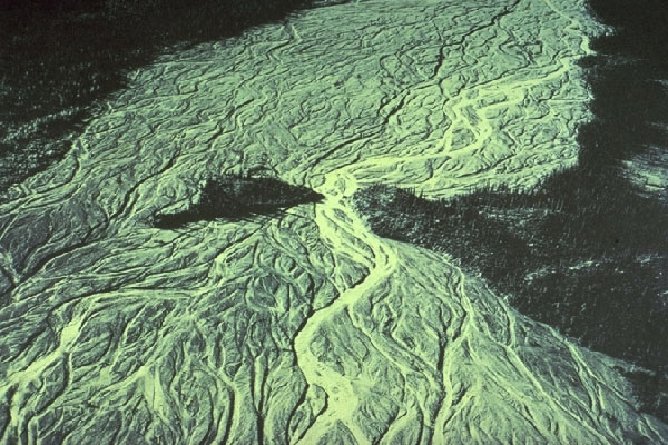 Fig. 12-34. Braided streams form in stream valleys overloaded with available sediments, back filling valleys with sediments. |
Changing Base Levels and the Formation of Stream Terraces |
|||
| Through time, stream valleys are constantly changing. One stream drainage may grow at the expense of the ones adjacent to it. Base level is the lowest level to which a land surface can be reduced by the action of running water. It is typically equivalent to the lowest point a river or stream can reach entering the ocean or other large body of water. Base level of a stream entering the ocean will rise and fall with changes in sea level. A stream terrace is one of a possible series of level surfaces on a stream valley flanking and parallel to a stream channel and above that marks the level of a floodplain in the geologic past. A change in stream gradient or stream flow can cause streams to carve into their floodplain, leaving a step like terrace along the side of the valley. Multiple events related to these changes can leave a series of step-like terraces (old floodplain surfaces) preserved along a stream valley. The erosional down cutting of a stream into its floodplain is called rejuvenation. |
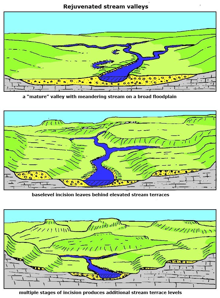 Fig. 12-35. Formation of stream terraces along a rejuvenated stream valley. Climate changes, sea level changes, and tectonic uplift can cause streams to cut into their floodplains producing abandoned stream terraces. |
 Fig. 12-36. Terraces along Arroyo Seco Canyon in central California reflect landscape change including uplift of the Coast Range and changes caused by sea level changes along the coast caused by the ice ages. When sea level rises, the streams back fill their valleys with sediments and form floodplains. When sea level falls the stream gradient increases, and streams carve into their valleys. |
 Fig. 12-37. The Goosenecks of the San Juan River in New Mexico is an example of a rejuvenated stream valley. The river was originally a meandering stream on a broad floodplain. Uplift in the region (or other causes) caused a change in stream gradient, causing the river to cut into its meandering channel, creating the unusual shape of the San Juan River canyon. |
Floods Don't Have To Be DisastersFloods are a natural cycle of all stream and river drainages. During times of flood, rivers overflow their banks and levees and pour sediment-laden water onto low lying areas, providing new sediments (and nutrients of plants) to their floodplains. Figures 12-38 to 12-40 are airliner views of rivers in flood. The natural levees are cover with trees and stand out avoid the flooded floodplain. One of the most important geologic principles is never build on a floodplain ...a rule that has failed repeatedly throughout history. |
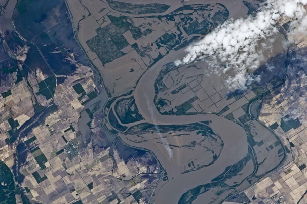 Fig. 12-38. A river in flood. Sediment-laden waters cover the entire floodplain. |
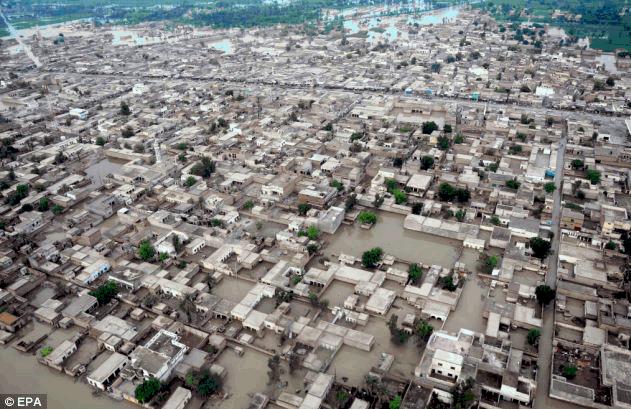 Fig. 12-39. The 2011 flood in Pakistan caused major devastation of a large region, impacting millions. |
 Fig. 12-40. 2009 Flood in Grand Forks, North Dakota. Winters with heavy snow lead to spring floods. |
|
||||||||||||||||||||||||||||||||||||
Groundwater |
| Groundwater is water beneath the land's surface, filling pore spaces in saturated soil and rock. It is water that supplies wells and springs. Whereas hydrology is the science concerned with the properties of the earth's water, especially its movement in relation to the land's surface. The study of groundwater is called geohydrology (or hydrogeology). Porosity and PermeabilityWhat is the difference between porosity and permeability and how these relate to the movement of groundwater?Porosity is the state of being porous, or the ratio of the volume of all the pores (gas- or fluid-filled space) in a material to the volume of the whole. Permeability is a measure of the ability of a porous material (rock or unconsolidated sediments) to transmit fluids. Rocks and sediment have very different characteristics in regard to porosity and permeability (Figure 12-41). For instance: * Sand and gravel have both high porosity and high permeability (sandstone and gravel may be less so because much of the pore space is filled in with cement). * Mud and shale have high porosity but very low permeability (because fine-grained particles impede the flow of water). * Fracture rocks like granite or volcanic and metamorphic rocks may have low porosity, but the fractures allow water to flow, so they may have high permeability. |
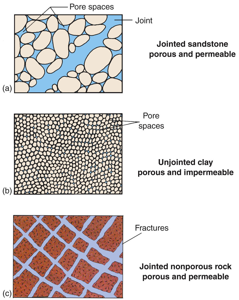 Fig. 12-41. Examples of porous and permeable materials. |
Where does water occur in the subsurface?Geologists use the terms aquifer, aquitard, and aquiclude to describe the character of rocks in the subsurface in relation to whether or not they can contain or provide a supply of groundwater (Figure 12-42).An aquifer is a porous and permeable rock or sediment layer, such as a sand or sandstone, containing groundwater that can be used to supply wells. An aquitard is a zone or layer of low permeability adjacent to an aquifer; the permeability is so low it cannot transmit any useful amount of water. Aquitards act as confining layers to confined aquifers. Confined aquifers can be used as water storage. An aquiclude is an impermeable body of rock or stratum of sediment, or an impermeable fault zone, that acts as a barrier to the flow of groundwater. The water table is the level below which the ground is saturated with water. The water table is typically close to the surface in unconsolidated sediments in humid regions, but may be deep below the surface in arid region, especially in regions of heavily fractured bedrock in areas of high relief (mountains). The water table may rise as precipitation soaks into the ground, recharging an aquifer. Water tables and may fall during periods of drought or when water is pumped from the ground faster than it can recharge (discussed below). In many locations, both permeable and impermeable layers occur interbedded together. Where an impermeable layer (an aquitard or aquiclude) creates a local perched water table. Seeps and springs on the sides of cliffs and canyons often are associated with perched water tables. The surface of a lake, pond, or stream typically is in relatively stable equilibrium with the local water table (see Figure 12-42). Groundwater Basins and Major Aquifers in the United StatesDifferent regions in the United States have different sources of water. In many regions water from underground reservoirs are the primary source for drinking water in agriculture. Figure 12-41 is a map of the United State showing regions where aquifer are utilized. The colors on the map basically follow the distribution of geologic rock formations that are also major aquifers. For instance, the Great Plains region is underlain the Ogallala aquifer. The aquifer corresponds with the Ogallala Group of Formations composed of sediment ranging form about 33 million years to less that 12 million years. The Ogallala aquifer formed from sandy sediments eroded from the Rocky Mountains and deposited across the Great Plains region. Much of the water in the aquifer is old, having accumulated in the aquifer during the past ice ages. In many areas this water is being mined (pumped slowly dry) to support agricultural activity in the region. |
 Fig. 12-42. Features associated with water underground. 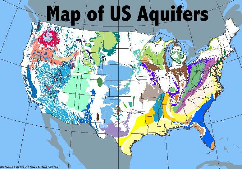 Fig. 12-43. Groundwater map of the US showing the location of major aquifer regions. Aquifers are associated with major sedimentary rock formations. |
Saturated vs. Unsaturated ZonesThe water table is the level below which the ground is saturated with water (Figure 12-44). The water table is influenced by the gravitational flow of water underground, typically following the general topography of a landscape, but can be changed by the extraction of water from a well, or construction of a dam. The groundwater table rises and falls with changes in seasonal precipitation.The phreatic zone is the zone of saturated rock or sediment below the water table where pore spaces between grains or within fractures are mostly filled with water (also called zone of saturation). The vadoze zone (also called the unsaturated zone) is the typically shallow subsurface interval between the land surface and the underlying phreatic zone or zone of saturation. The vadose zone extends from the top of the ground surface to the water table. In many places there is a zone called the capillary fringe. Capillary fringe is a subsurface layer above the water table in which groundwater seeps up from a water table by capillary action to fill pores. |
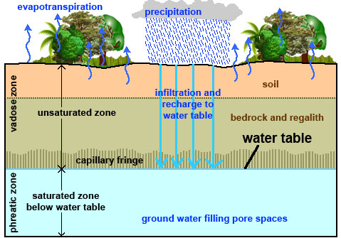 Fig. 12-44. Water table is the boundary between the saturated phreatic zone and unsaturated vadose zone. A zone called a capillary fringe exists in many place just above the water table. |
Springs and WellsA spring is any natural occurrence where water flows to the surface from below ground. Springs typically occur in locations where the water table in an aquifer meets the ground surface, allowing water to discharge onto the surface or into a body of water (such as a stream, lake, or the ocean). In arid regions, springs are commonly revealed by an abundance of plant growth in the vicinity where water is at or near the surface.A well is simply a hole dug or drilled in the ground that descends through the water table for the purpose of extraction of fluids (water, oil, and gas). Wells in unconfined aquifers will fill with water to the level of the water table (Figure 12-45). An artesian well is a well drilled through impermeable strata to reach water in a confined aquifer capable of rising to the surface by internal hydrostatic pressure (Figure 12-46). In geohydrology, the word head is used to describe the height that groundwater will rise in a confined well under artesian water pressure. The Effects Of Water Extraction From a WellPumping water out of the ground faster that groundwater can refill the pore spaces in the saturated zone will cause the water table to fall. The drawdown of a well is a reflection of the reduction in the volume of water in an aquifer. Drawdown is also used to describe the reduction in the volume of water in a lake or reservoir. In many places a lake or pond is just part of a larger reservoir involving water on the surface and underground.When water is pumped from an unconfined aquifer it will create a cone of depression (Figure 12-47). A cone of depression is an inverted cone-like depression in the water table caused by groundwater extraction in a well in an unconfined aquifer. When too much pumping takes place, the cone of depression will sink to the base of a well, and it will run dry. When a well is shut off, the cone of depression will rise again as water returns to the depleted zone. Unfortunately in many dry regions around the world, wells keep running dry, so people drill deeper wells. In many places, this unsustainable drawdown not only mines the water, but can steal water from other wells nearby (Figure 12-43). In some places, the groundwater supply has been so depleted that the water table has sunk hundreds or even thousands of feet from its original level. There are many negative side effects (discussed below). |
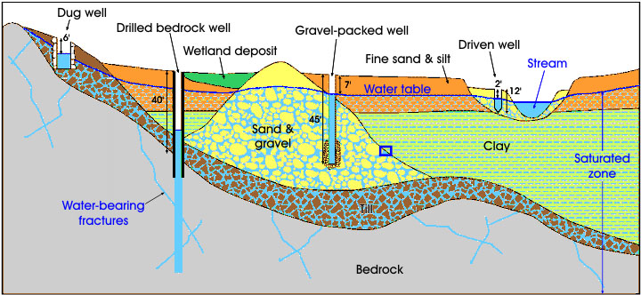 Fig. 12-45. Springs, wells and groundwater 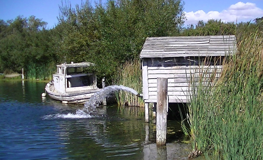 Fig. 12-46. This artesian well flows into McAlpine Lake near Gilroy, California. 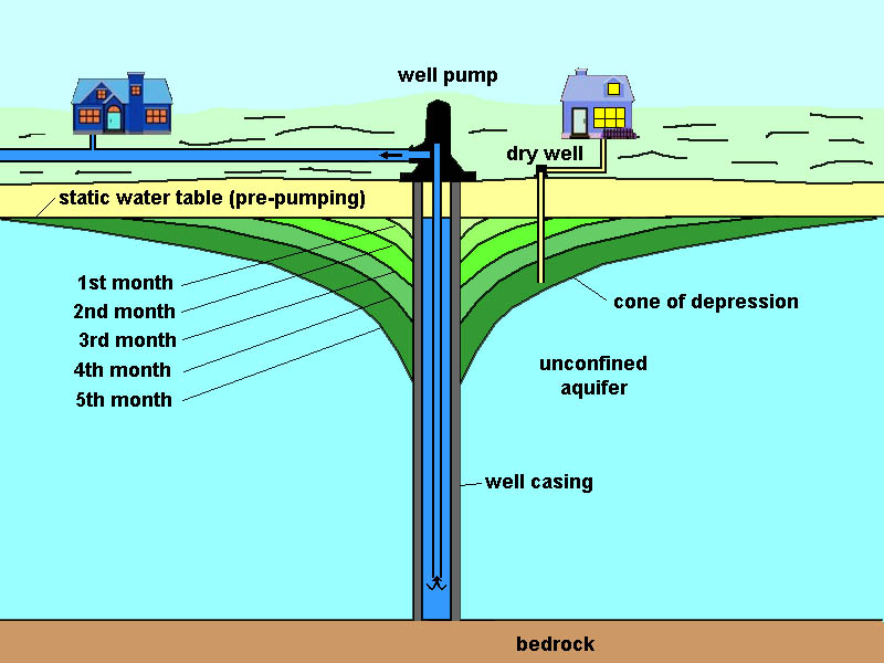 Fig. 12-47. A cone of depression forms from the drawdown of a well by pumping out groundwater. |
Influent and Effluent StreamsChanges in the level of a water table can influence whether water sinks into the ground or flows to the surface.Bank storage is water absorbed and stored in the permeable voids in the soil cover in the bed and banks of a stream, lake, or reservoir. The water returns in whole or in part as the level of water body surface falls. An influent stream is a stream that contributes water to the zone of saturation of groundwater and develops bank storage. An effluent stream is a stream that is fed by groundwater seeping to the surface (Figure 12-48). When large quantities of water are pumped from an unconfined aquifer a stream flowing across the area may loose some or all of its water into the subsurface if the drawdown of the water table is significant, and the ground beneath the stream consists of highly permeable sediments or rocks. |
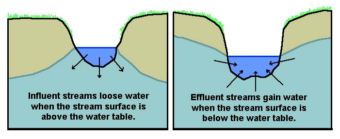 Fig. 12-48. Influent and effluent streams react to levels in the water table relative to the surface level of a stream. Fig. 12-48. Influent and effluent streams react to levels in the water table relative to the surface level of a stream. |
Problems Caused By Over-Pumping GroundwaterOver pumping of groundwater causes a myriad of problems. If local precipitation and groundwater recharge does not keep up with well-water extraction, then the groundwater table subsides, and shallow wells go dry as deep wells are drilled nearby. In arid regions throughout the western United States, the groundwater table has gone down hundreds, even thousands of feet, and the aquifers no longer can be used as a source of water.Over pumping also causes subsidence—the lowering of the land surface. Subsidence also occur in areas where extensive extraction of water or petroleum allows pore spaces between grains or fractures in rock to collapse, reducing volume, and resulting in subsidence of the land's surface. Although subsidence can be caused by tectonic forces, in many places, too much groundwater extraction is causing the surface of the land to sink. Classic examples include what is happening to Houston, Texas, but subsidence is occurring anywhere where well water is used in excess of recharge (Figure 12-49). Major subsidence cause by over pumping of groundwater has occurred throughout portions of the Central Valley and around the San Francisco Bay region. Subsidence results in land loss and increases the impact of flooding along coastal regions. Over pumping harms wildlife. Lower water tables prevent water from draining from springs or shuts down stream flow that would otherwise be available as a water source for wildlife, resulting in the loss of wildlife habitats. Over-pumping causes springs and streams to dry up. Plants called phreatophytes tap into the groundwater below the water table, and can loose their water supply from over-pumping and lowering the groundwater table, especially in riparian habitats along streams in arid regions. Salt water intrusion is the contamination of groundwater by seawater caused by too much well water withdrawal from an unconfined coastal aquifer (Figure 12-50). In many urban areas, salt water intrusion is being combated by pumping used urban water (including treated sewage) into coastal aquifers in an attempt to create a freshwater barrier to keep saltwater from migrating for the sea back into coastal aquifers. |
 Fig. 12-49. Subsidence in the Houston-Galveston area 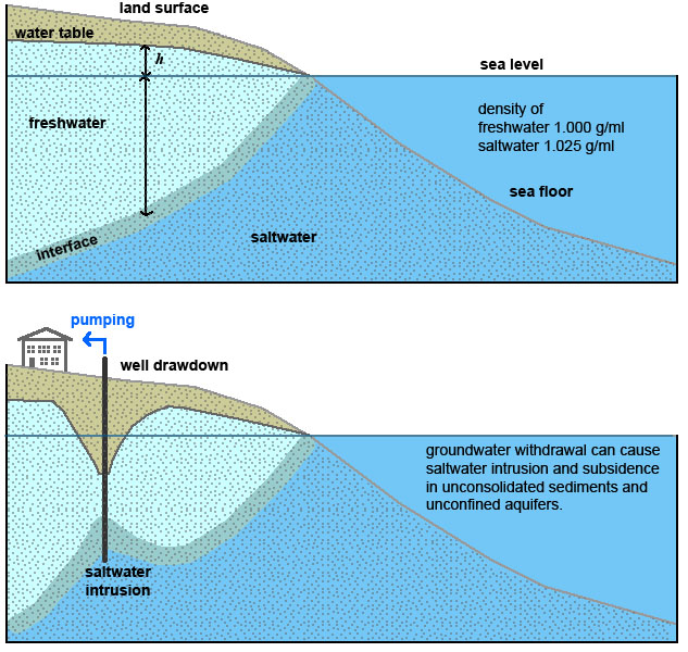 Fig. 12-50. Saltwater intrusion caused by over pumping |
Water Pollution From Point and Non-Point SourcesFreshwater on the surface (rivers, lakes, and streams) and underground can become polluted from a variety of ways; they are lumped together in two groups: point and non-point sources (Figure 12-51).Point sources are places where pollutant materials originate from a single known locality, such as pollution from the effluent of a poorly designed sewage treatment plant, a landfill, or a spill associated with a hazardous waste site. Point sources can typically be contained (or better prevented in advance). Non-point sources of pollution are more problematic because their origin is not from an easily identifiable source. Examples include acid rain created by industrialization, oil and other waste from trucks and automobiles, air pollution, pesticides and fertilizers used in agriculture can become widely distributed by the wind. DDT, a pesticide widely used in the 1950 and 1960s was finally banned in the United States in 1972, but it can still be found in trace amounts throughout the environment today. |
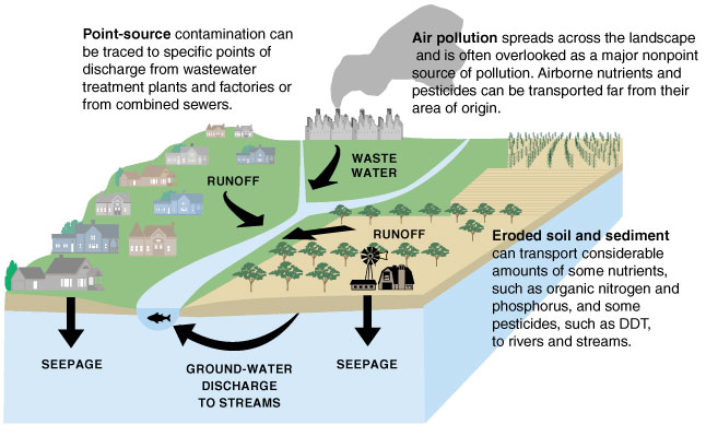 Fig. 12-51. Point source and non-point source pollution of streams and groundwater. |
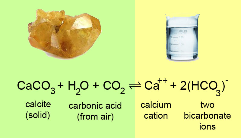

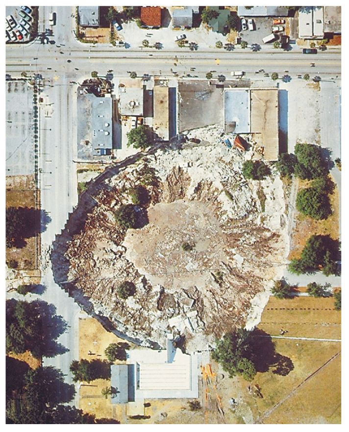
Caverns form mostly below the water table in regions underlain by limestone (Figures 12-58 and 12-59). Flowing water along fractures and faults erode and expand underground passageways. Over time, streams carving through limestone (karst) areas lower the stream base level, causing the water table to fall. This leaves passages that were once filled with water high and often quite dry. Once exposed to the air, water seeping into the cavern carries dissolved calcium carbonate. When the water evaporates, it leaves behind a residue of calcium carbonate called travertine. Travertine is a white or light-colored calcareous rock deposited from mineral springs; or a common name for freshwater limestone deposits. Most cavern speleothems consist of travertine.
Speolothems and Cavern FeaturesA speleothem is a structure formed in a cavern by the deposition of minerals (usually calcite [in the form of travertine] precipitated from water), including such features as stalactites, stalagmites, columns, flowstone, or other features found in caverns that form above the water table (Figure 12-60 to 12-66).A stalactite is a tapering structure hanging like an icicle from the roof of a cave, formed of calcium salts deposited by dripping water. A stalagmite is a mound or tapering column rising from the floor of a cave, formed of calcium salts deposited by dripping water and often eventually uniting with a stalactite to form a column. Wildlife Underground: Many cavern systems are host to wildlife adapted to living underground in the absence of light. Creatures including blind fish, blind crayfish, cave crickets, and many others can survive without sight underground. These creatures are called troglodytes. |
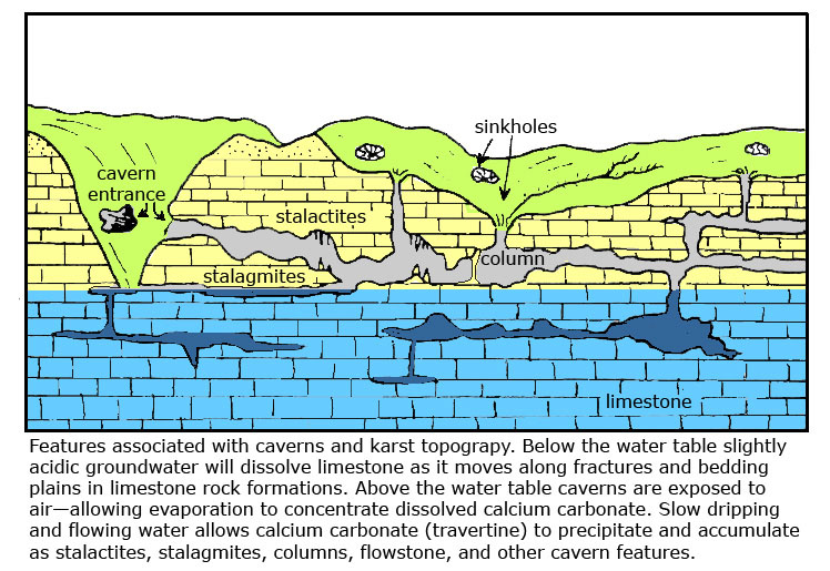 Fig. 12-58. Landscape features associated with karst and cavern development. |
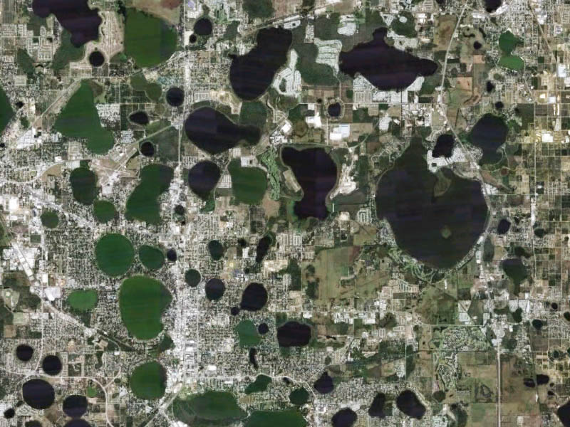
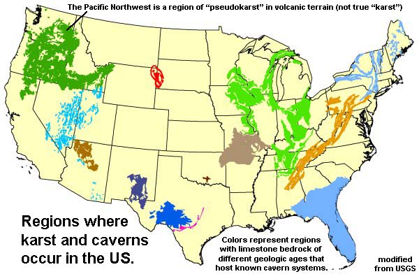 Fig. 12-59. Regions where karst and caverns occur in the United States. |
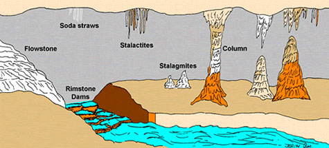 Fig. 12-60. Speleothems: flowstone, stalactite, stalagmites, and columns |
 Fig. 12-61. The natural cavern entrance to Mammoth Cave, Kentucky is a massive sink hole. |
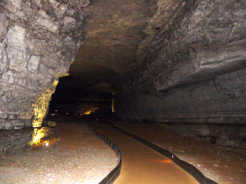 Fig. 12-62. Underground stream erosion carved this massive passage in Mammoth Cave, Kentucky. |
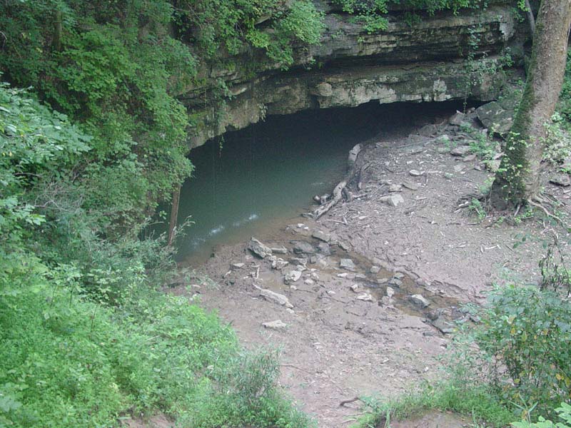 Fig. 12-63. The River Styx drains from an underground stream in the Mammoth Cave System. |
|
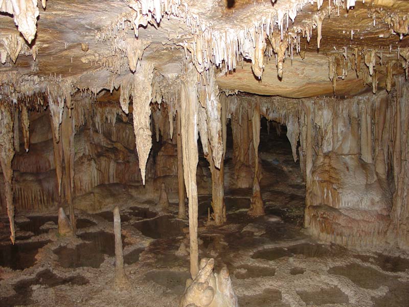 Fig. 12-64. Stalactites, stalagmites, columns, and travertine dams in Lehman Caverns, Nevada. |
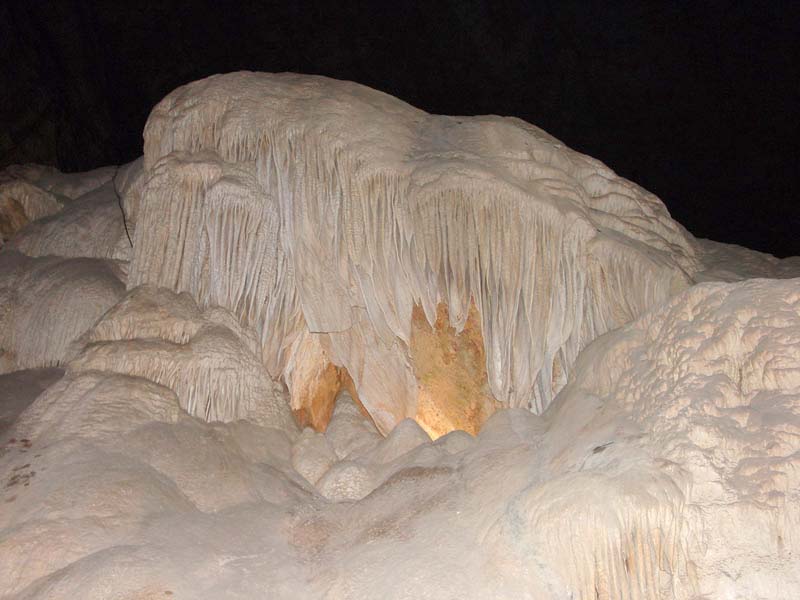 Fig. 12-65. Massive deposit of travertine flowstone in Carlsbad Caverns, New Mexico. |
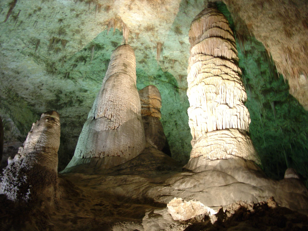 Fig. 12-66. Massive stalagmites in a passage in Carlsbad Cavern, New Mexico. |
| Websites About Selected National Parks with Caverns Guadalupe Mountains National Park Carlsbad Caverns National Park Great Basin National Park Wind Cave National Park Jewel Cave National Monument |
Water Resources of the United StatesPolitical, social, and economic factors influence the use and distribution of water resources anywhere in the world, and especially here in the arid western United States. With growing populations and wealth create higher demands on water resources. Questions of water rights is all about money and survival,—pitting neighbors, land owners, land managers, communities, cities, states, regions, and countries against one-another. Each region has its unique history.Figure 12-67 is a map of the watershed boundaries of the United States. Rivers define many state boundaries, and portions of the boundary between the United States and Canada and Mexico. Figure 12-68 is a map of the principal aquifers of the United States. In many regions throughout the United States vast quantities of water are trapped in the subsurface, and the water has accumulated there over hundreds to many thousands of years, often since the ice ages when the United States region was both colder and wetter. Many of these aquifers are being mined of their water, that is, the aquifers are being drained faster than they can be recharged by natural precipitation. Each of the aquifer systems have unique geologic characteristics (origin and history) and recharge characteristics. Rivers and streams discharge water into aquifers in some regions. In other regions, stream flow is maintained by the steady discharge of groundwater through seasonal or longer periods of drought. |
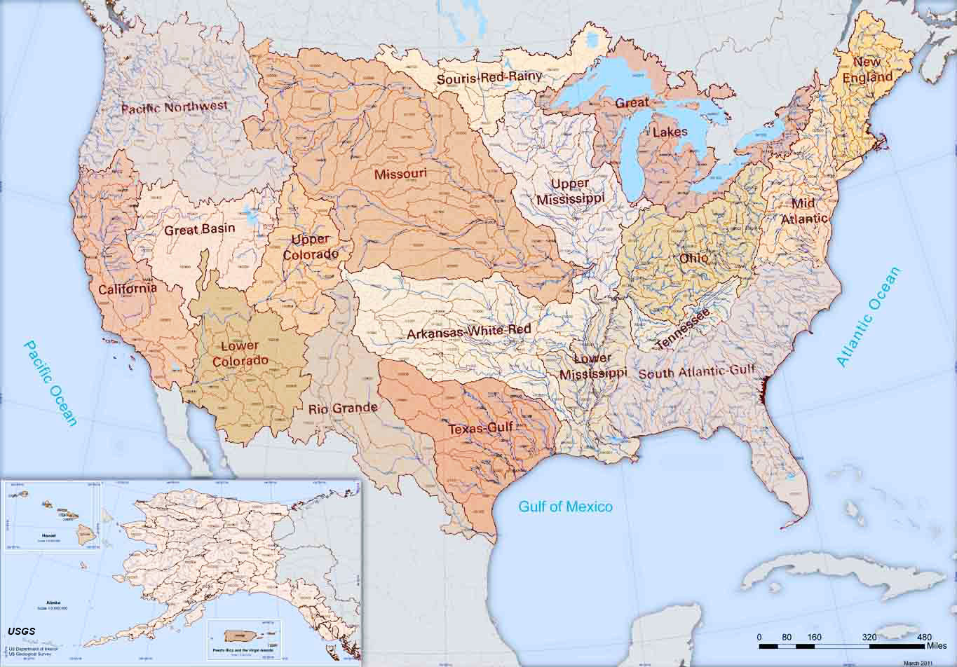 Fig. 12-67. Watershed boundaries of the United States (USGS) 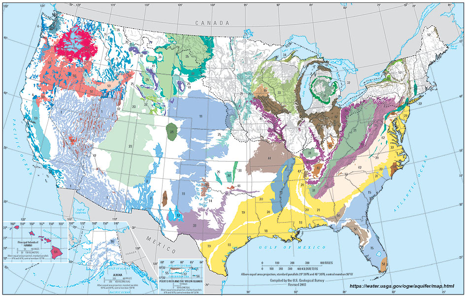 Fig. 12-68. Principal Aquifers of the United States (USGS) |
| Learn more about water resources for the country individual states from the US Geological Survey, Water Resources Division. The USGS maintains water-measurement infrastructure and data collection for the country. The USGS's exhaustive water-resources website provides current and historical data on: • streamflow (including flood and high flow) • drought • surface waters • groundwater • water quality • water use • contamination and pollution |
The Colorado River Water Story |
|
| The Colorado River has had the longest and perhaps most contentious story of water conflicts in the United States history.
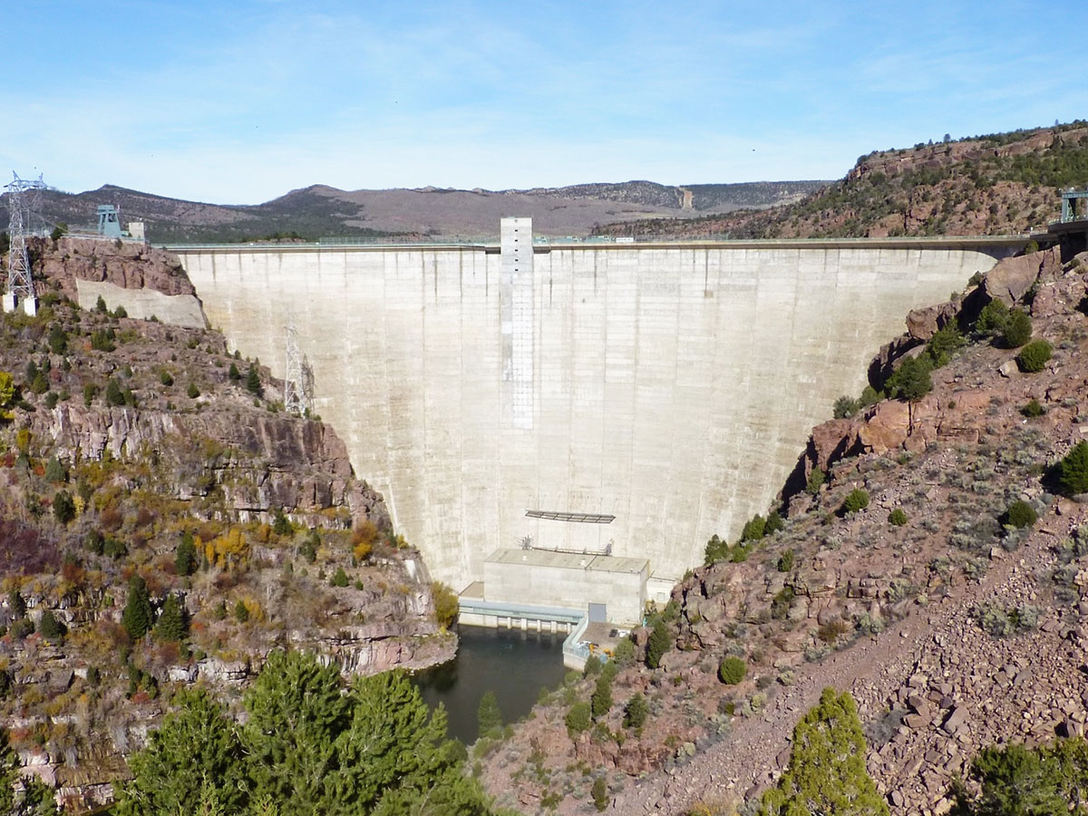
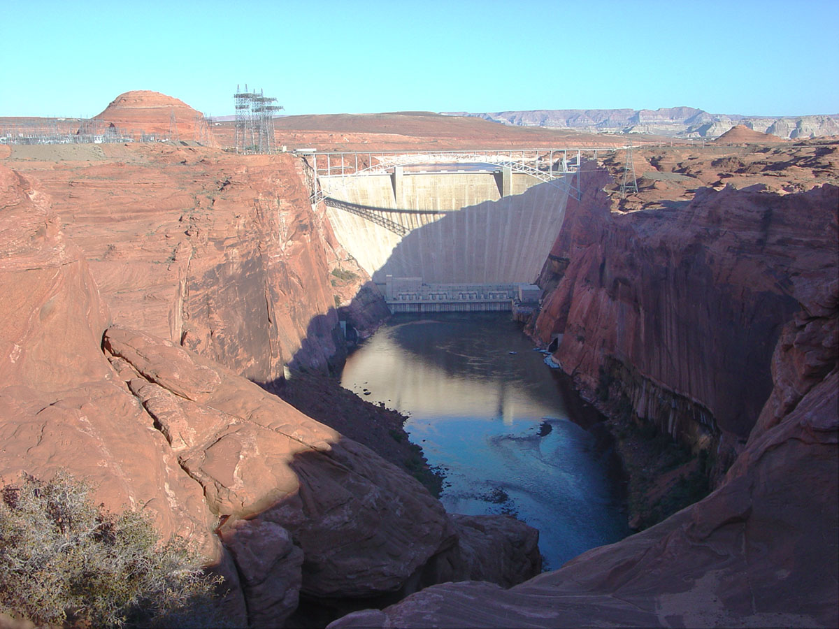
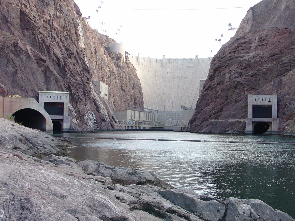
In 1922, Congress authorized the Colorado River Compact, first national agreement about who gets, and how much, Colorado River water. Seven states and Mexico all rely on the Colorado River. The Colorado River watershed was split into the Upper Basin (parts of Colorado, Utah, Wyoming, Arizona, and New Mexico) and Lower Basin (parts of California, Arizona, and Nevada) (Figure 12-69). The Colorado River Compact split the water equally between the Upper Basin and Lower Basin, each share getting what was estimated amount of 7.5 million acre-ft/year. (One acre-foot equals about 326,000 gallons, or enough water to cover an acre of land, one foot deep.) Initially, the Upper Basin had a surplus of water, and the surplus was passed to the Lower Basin. However, the growing demand for water in southern Arizona, California, and the Las Vegas region forced ongoing negotiations, eventually including Mexico as part of the negotiations, and renegotiations. The initial estimates of available water in the river system was too high, and droughts have resulted in shortages. Many political and environmental battles have raged (and continue to rage) over the limited water resources of the Colorado River, especially related to the construction and management of the high dams constructed along the river (Figures 12-70 to 12-73). The dams serve to regulate water supply, generate electricity, provide sport recreation, and to divert water to support an expanding economic developments in the region. However, the dams have also significantly altered the natural environments along the watershed, particularly relating to the national parks that dominate much of the scenic landscape along the river drainage. States are constantly evaluating water restrictions and conservation programs, and attempting to create incentives for water conservation. |
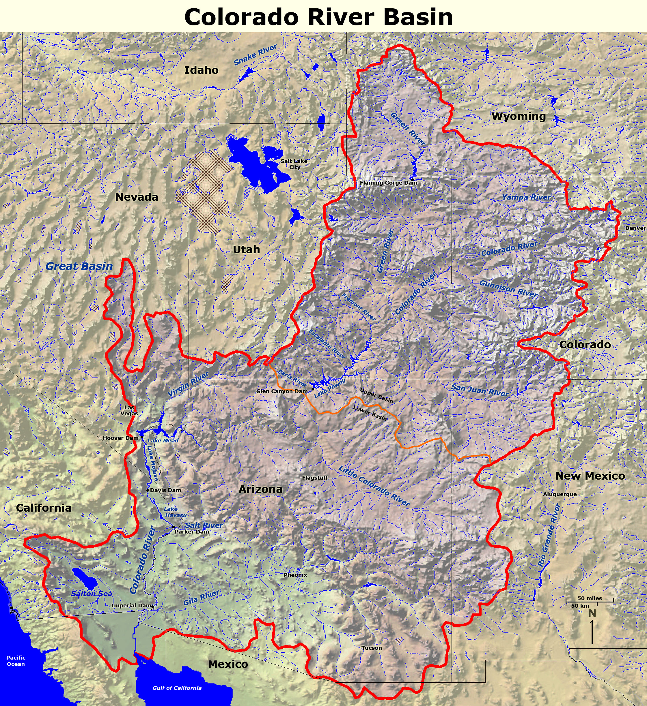 Fig. 12-69. The Colorado River watershed is subdivided into two political regions, the Upper and Lower Basins. |
|
California's Water Distribution SystemThe water supply and distribution system in California is the largest, controversial, most complex, and most productive in the world, involving trillions of dollars worth of infrastructure and the associated unending political battles and legal expenses over time (Figure 12-74). The infrastructure includes a massive network of massive dams and reservoirs, levees, aqueduct systems, pipelines, tunnels, pumping stations, desalination plants, and more. The system distributes water to over 30 million people and almost 6 million acres of agricultural land.Historically, the water issues in California have been extremely controversial, involving a constant shift in the balance between the agricultural demands for water mainly in the Central Valley versus the water demands of the expanding urban populations in the coastal metropolitan regions. In addition, there are substantial concerns about protecting the remaining delicate ecosystems along watersheds in the region. California's water infrastructure is also extremely vulnerable to potential damage from earthquakes floods, and deterioration from lack of maintenance—a result of economics and political neglect. |
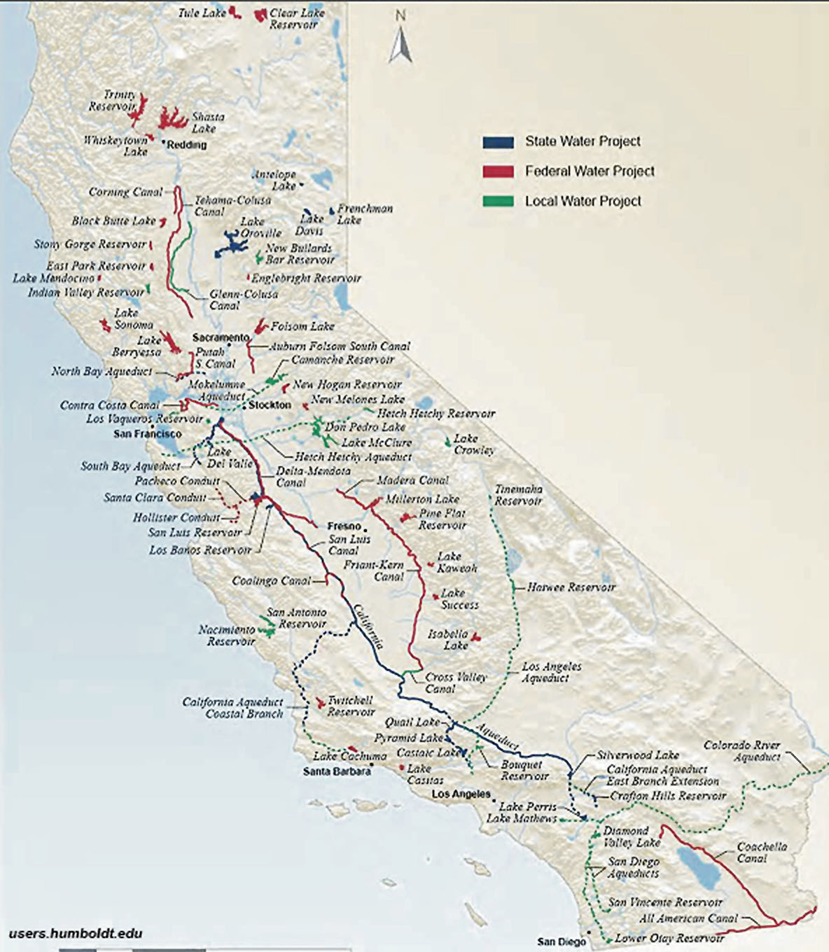 Fig. 12-74. California's water distribution system. |
| Learn more about water in California: California Department of Water Resources |
National Parks Associated With Caves, Caverns, and Karst Landscapes |
|
| Many parts of the country are underlain by limestone rock formations that are host to caverns and karst landscapes. Some caves are actually lava tubes or open fractures or slot canyons buried beneath boulders. 36 states are know to have caverns or caves. Missouri alone has ~6,400 caves, and Kentucky's Mammoth Cave is arguably the largest cavern system in the world. Although many national parks host caves and caverns, the parks listed below are noted for their caverns (or lava tubes) that are open for public tours. |
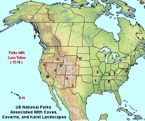 |
| Buffalo National River, AR - 1 Carlsbad Caverns National Park, NM - 2 Cumberland Gap National Historical Park, KY, TN, VA - 3 Great Basin National Park, NV - 4 Jewel Cave National Monument, SD - 5 Mammoth Cave National Park, KY - 6 Oregon Caves National Monument & Preserve, OR - 7 Ozark National Scenic Riverways, MO - 8 Russell Cave National Monument, AL - 9 Sequoia & Kings Canyon National Parks, CA - 10 Timpanogos Cave National Monument, UT - 11 Wind Cave National Park, SD - 12 |
|
| Parks With Lava Tubes (of volcanic origin) Craters of the Moon National Monument & Preserve, OR - 13 El Mal Pais National Monument, NM - 14 Hawaii Volcanoes National Park, HI - 15 Lava Beds National Monument, CA - 16 |
|
|
Chapter 12 Quiz Questions
|
| https://gotbooks.miracosta.edu/earth_science/chapter12.html | 11/6/2023 |