
Introduction to Physical Geology |
Chapter 13 - Deserts and Arid Regions |
This chapter focuses on landscape features and climate conditions associated with deserts and arid lands. |
Click on thumbnail images to get a larger view. |
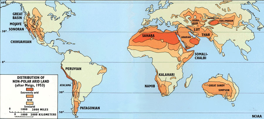 Fig. 13-1. Earth's desert regions. |
Factors Influencing the Location Of Deserts and Arid LandsMany geographic and atmospheric conditions influence where desert conditions prevail, or how they can change over time. Factors include:* Global wind patterns - control regional weather and climate patterns. * Rising winds (low pressure) cool, causing precipitation; whereas sinking winds (high pressure) warm and become unsaturated and dry. * Arid environments occur in both warm and cool climate regions. * Seasonal weather patterns also influence arid weather patterns (summer drought and winter monsoons). * Mountain ranges block atmospheric flow, forcing precipitation on the upwind side, and rainshadow (desert) conditions may prevail downwind. * Drought may create temporary desert conditions. * Regional and global climate changes can expand or shrink desert regions. |
Global Atmospheric Circulation Patterns and DesertsDesert regions are not limited to hot climates, but it is related to the amounts of precipitation a region receives (Figures 13-2 and 13-3). The location of desert regions has most to do with the global atmospheric circulation system. The global wind circulation patterns is fueled by incoming solar radiation and moderated by water temperatures in the global oceans. Near the equator, where solar heating is direct and most intense, the air is warm and picks up moisture from the oceans. Along the Inter-Tropical Convergence Zone, warm moist air rises, expands, cools, and produces precipitation (Figure 13-4). The air depleted of its heat and moisture moves northward and southward from the equatorial region to a region roughly 30º north and south of the equator to a subtropical regions where dominantly high atmospheric pressure causes the winds to sink back to the surface (called sinking winds). As they sink they warm up and become even dryer. This generally explains the location of most of the desert regions around the world.A rainshadow is a dry region that occurs on the downwind side of a mountain range (or high volcano) that partially blocks the flow of moist air, forcing precipitation on the prevailing windward side, and creates more arid conditions on the downwind side. Figure 13-5 illustrates the rainshadow effects caused by California's mountain ranges. High regions block or modify atmospheric circulation patterns. For instance the Himalayas and Tibetan Plateau produce the rainshadow effects experienced by Mongolia and western China (Gobi Desert). |
 Fig. 13-2. World average temperatures |
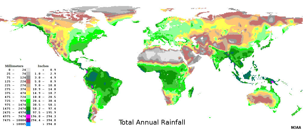 Fig. 13-3. World average rainfall |
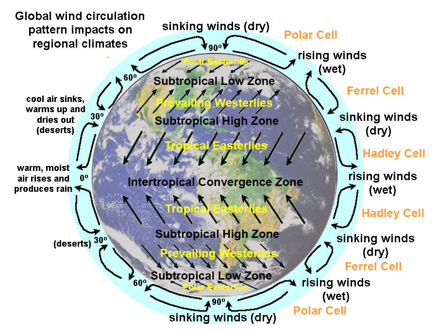 Fig. 13-4. Global wind circulation patterns impact regional climates. The world's large deserts occur where sinking winds produce arid conditions. |
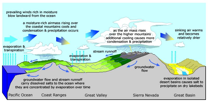 Fig. 13-5. California's desert regions: Prevailing winds from the ocean produce seasonal precipitation in the mountainous areas, but dry desert conditions prevail in the rainshadow regions east of the mountain ranges. |
Desert-like Areas Include Steppe and Arctic Tundra RegionsA steppe is a large semiarid area of relatively flat region covered with grasslands (mostly lacking forest cover), such as the Great Plains region of the United States and Canada. Large steppe regions occur in southern Russian and Siberia, and parts of Argentina and Australia.Tundra is a region of permanent cold that is largely or entirely devoid of life. Much of northern Alaska, Canada, and Siberia are regions that receive very little precipitation. Parts of Antarctica also are very dry despite being blanketed with ice. Drought can cause temporary desert-like conditions. Many parts of the American southwest from Texas to California have experienced major drought conditions. Long-term changes in the prevailing weather patterns in a region can set up drought conditions that my last for months to many years. During droughts, soil dries out and plant cover dies back. Drought causes desert regions to expand, especially when poor agricultural practices impact how the land responds to drought. The Dust Bowl was a period in the 1930s when in Oklahoma and Texas desert conditions prevailed in a region that under normal conditions received seasonal precipitation (Figure 13-6). Poor arid-land agricultural practices contributed to the Dust Bowl disasters. Dry microclimate regions: The orientation of a mountain slope can influence local climate conditions. For instance south-facing slopes in the northern hemisphere are typically warmer and dryer than north facing slopes. This is because the south-facing slopes receive more direct sunlight and experience more daytime heating and drying. It is common for mountain slopes in the American West to have grassy or barren slopes on the south side of mountains and forested slopes (or at least more vegetation) on their cooler, moister northern slopes (Figure 13-7). |
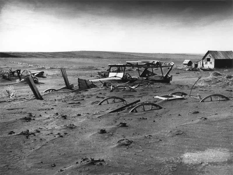 Fig. 13-6. Drought can create temporary or long-term desert-like conditions. |
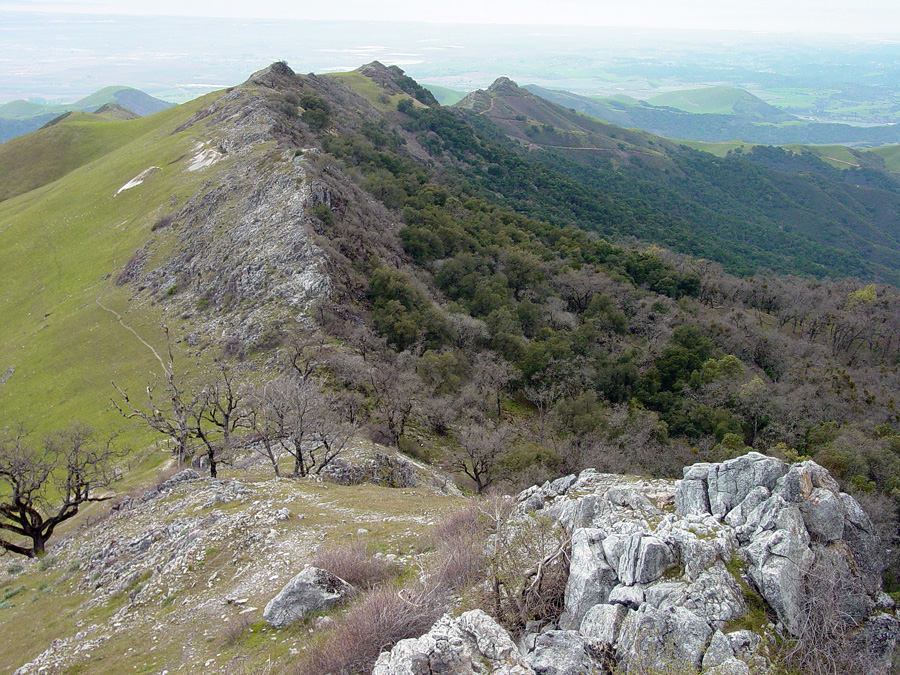 Fig. 13-7. Dry microclimates: south-facing slopes are drier than north-facing slopes in the northern hemisphere. |
How does precipitation and weathering affect surface topography of arid regions?Despite arid conditions in desert regions, precipitation in the form of infrequent thunderstorms is a primary cause of erosion in desert regions.Factors influencing weathering and erosion in desert regions include: * Bedrock composition and topography influence development of desert landforms. * Less weathering occurs in deserts because there is a lack of moisture and because there is reduced organic acids from plants. * Infrequent storms cause rapid erosion and prevent the establishment of plants and soil formation. * Intense rainfall causes flash floods and reduces infiltration. * Desert environmental conditions allow salts, particularly calcium carbonate, to accumulate and reduce porosity and permeability in surficial sediments. The lack of plant cover and prevailing arid conditions are apparent in desert regions, but it is the influence of infrequent but heavy rainstorms that dominate the formation of the landscape features in most arid environments. Despite arid conditions, running water is responsible for most erosion in deserts. |
Landforms and Landscapes in Desert Regions |
| Erosion and deposition produces a number of landforms unique to desert environments. Both erosional and depositional processes shape these landscape features. Desert erosional features include: • badlands • canyons and arroyos • pediments and inselbergs Desert depositional features include: • alluvial fans and bajadas • caliche and hard pans deposits • playas and salt pans • dunes Understanding the changing climate history of deserts is important!Many of the features preserved in desert regions reflect significant changes to the regional climate over time. During the last ice age (Wisconsin glaciation), the western United States was a much wetter and colder environment than today. When the ice age ended about 11,000 years, the region slowly dried up. Ecological succession replace pine and oak forests, shrublands, and grasslands with drought-tolerant plant species. Rivers and lakes in the basins between mountain ranges slowly dried up and vanished. The drying-out of the desert was interrupted with periods when rainfall returned, but the overall trend has been an increase in arid conditions. |
BadlandsBadlands are the name applied to uncultivatable land with typically very rugged relief, a heavily eroded appearance, and bares little or no vegetation (Figures 13-8 to 13-10). Badlands typically occur in soft or poorly consolidated sediments that erode quickly when infrequent rains occur. Lack of water and hot conditions prevent plants from getting established on slopes of soft sedimentary rocks that get scoured by heavy rainfall during infrequent thunderstorms in arid regions. |
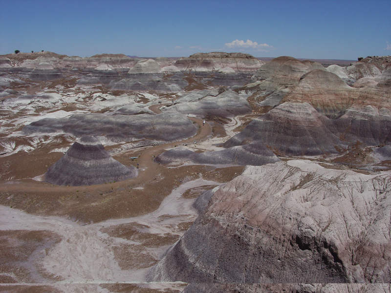 Fig. 13-8. Badlands in Petrified Forest National Park in the Painted Desert region of Arizona |
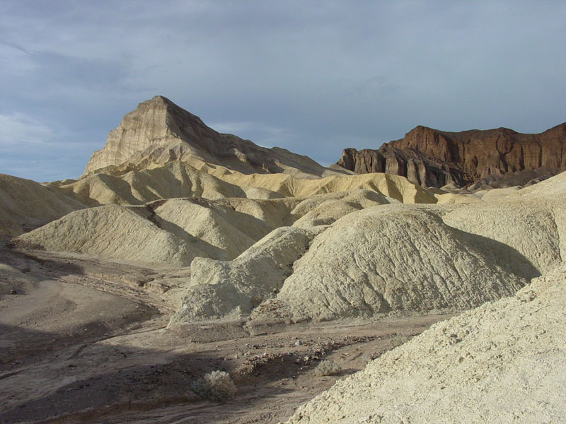 Fig. 13-9. Badlands (with Manly Beacon point) Death Valley National Park, California |
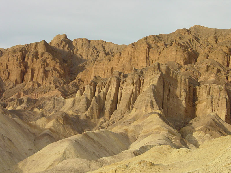 Fig. 13-10. Badlands of Golden Canyon in Death Valley National Park, California |
ArroyosAn arroyo is a watercourse (water-carved gully, channel) in an arid region (Figures 13-11 to 13-13). Arroyos are typically dry most of the time (they are ephemeral), but they are prone to flash floods after rare, seasonal thunderstorms. When flash floods occur in desert regions, the flow is often more a mix of flowing mud than water, and large amounts of material can be transported long distances, including large boulders (such as in Figure 13-13). The closest granite bedrock to this boulder is several miles away. |
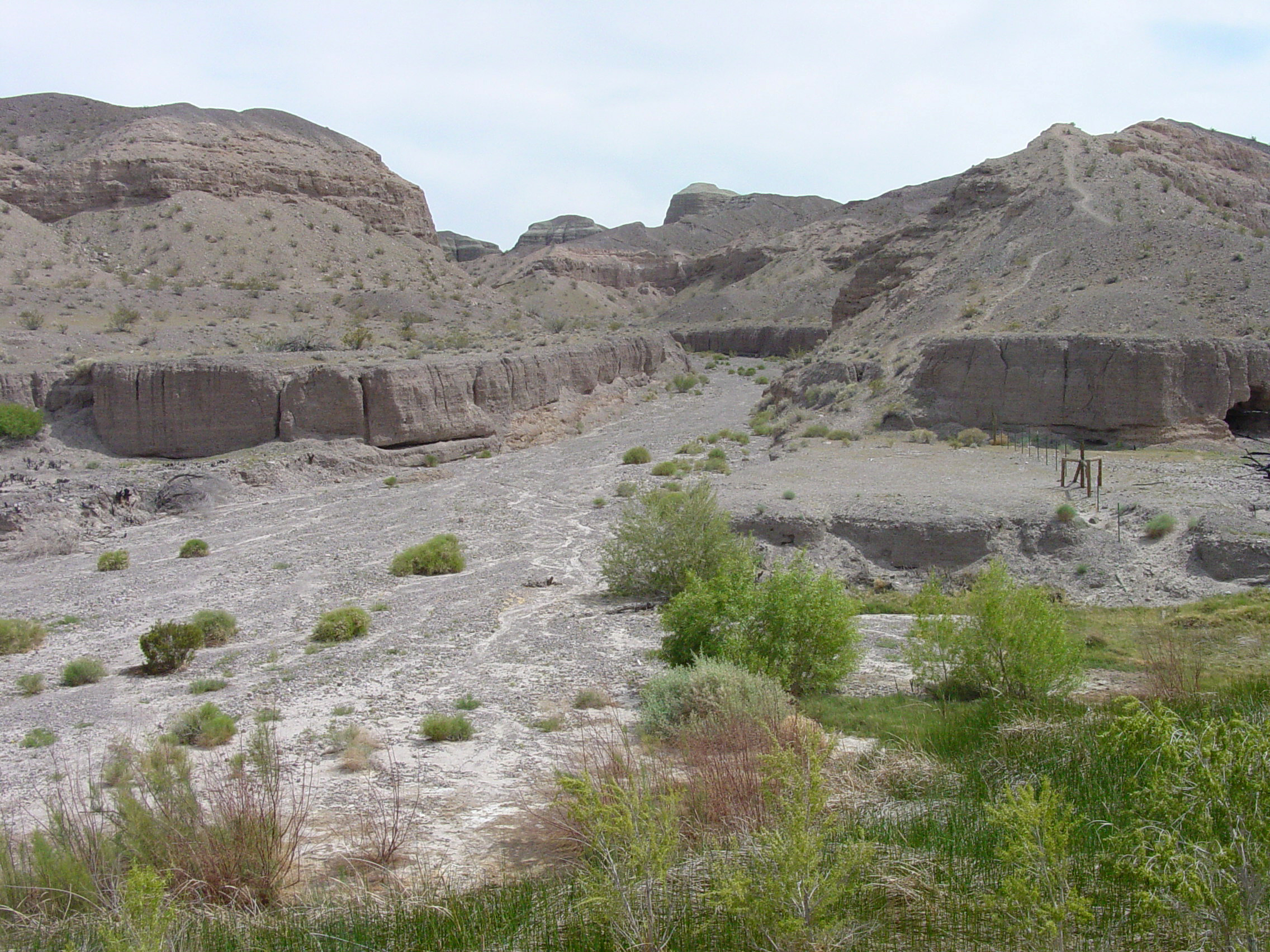 Fig. 13-11. An arroyo in Afton Canyon located in the Mojave Desert, California only flows during wet periods. |
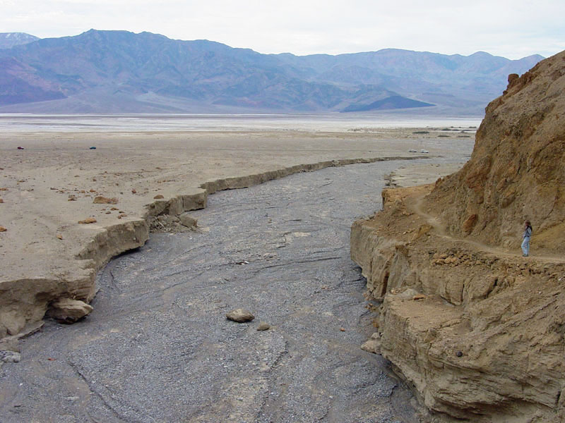 Fig. 13-12. Gower Wash (an arroyo) drains onto an alluvial fan in Death Valley National Park, California |
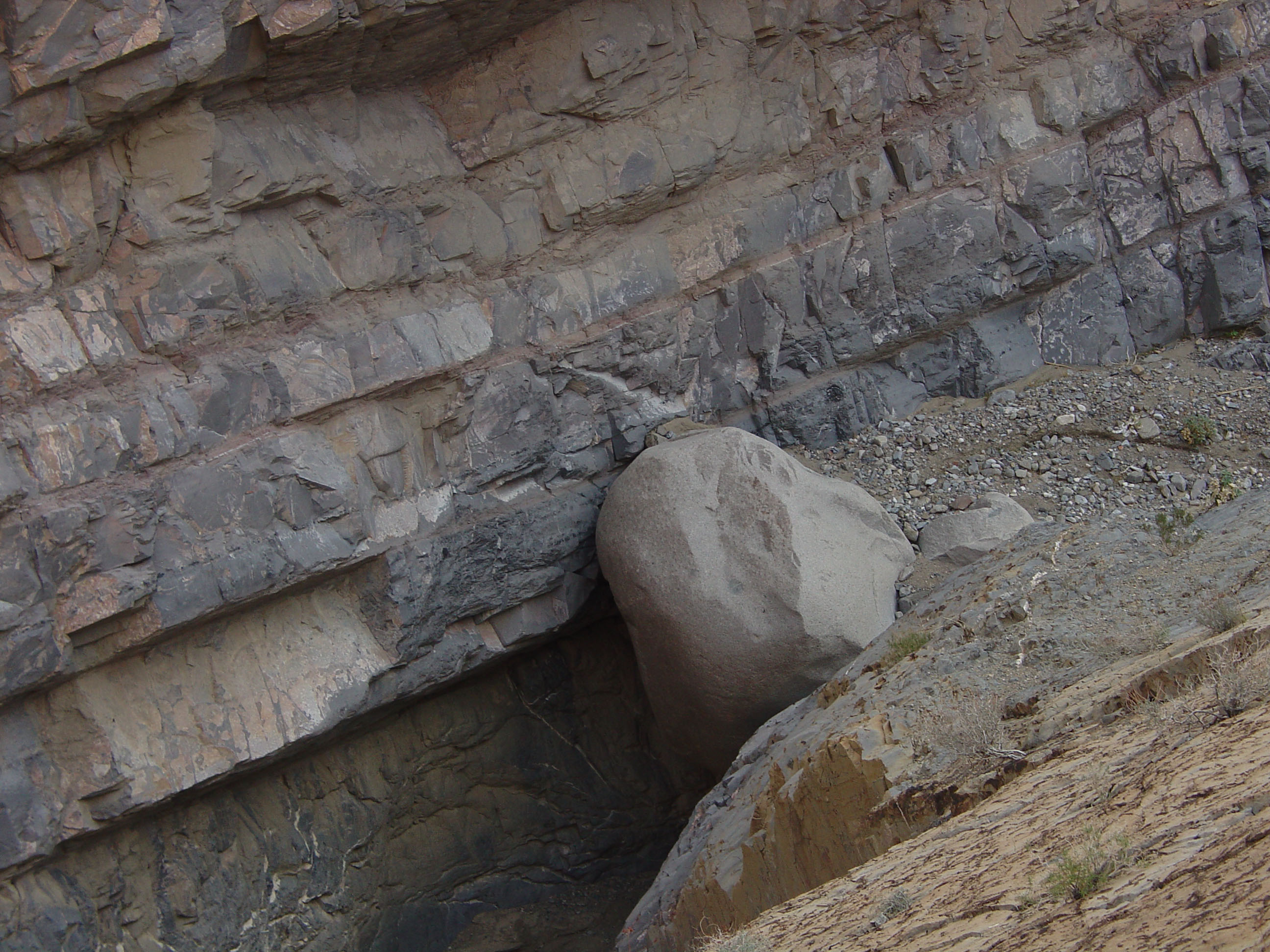 Fig. 13-13. Granite boulder (4 meter diameter) in bed of Marble Canyon in Death Valley National Park, CA |
Pediments and InselbergsA pediment is a gently inclined ancient erosional surface carved into bedrock that has typically developed at the foot of mountains, and may locally covered with thin deposits of stream gravel, and soil (Figures 13-14 to 13-16). Pediments are old surfaces that reflect the impact of erosion of rugged landscapes down to a planar surface over millions of years. A pediment develops when running water erodes most of the mass of the mountain down to a stream base-level consistent with the surfaces of surrounding alluvial fans in an arid or semiarid region. Pediment surfaces are often covered intermittently with a thin layer of sediments above deeply weathered bedrock. Down slope, pediments typically merge with alluvial fans (alluvial fans are discussed below). |
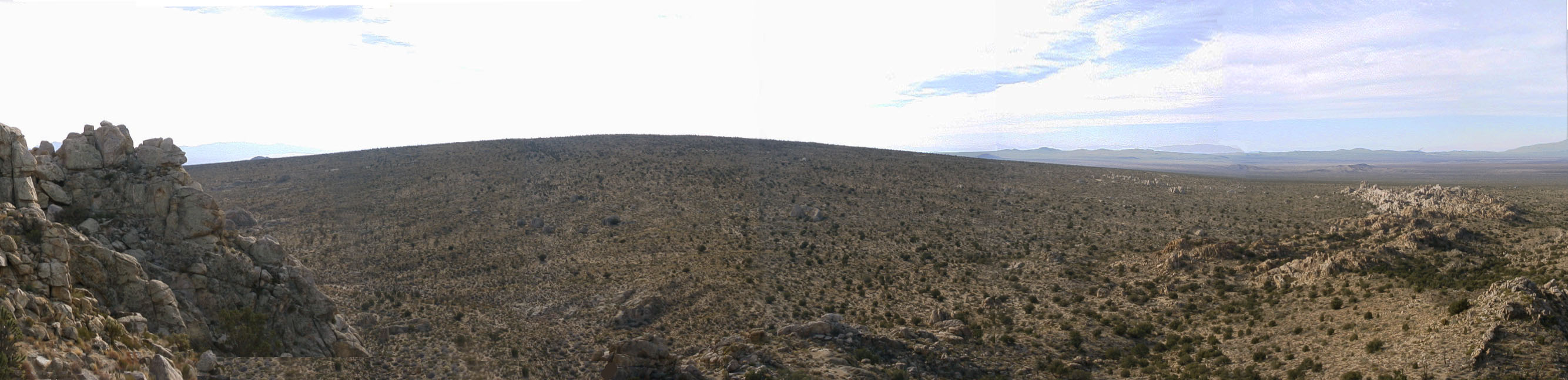 Fig. 13-14. Pediment surface with inselbergs (small bumps) on Cima Dome, Mojave National Preserve, CA. Cima Dome is a spectacular example of a mountainous landscape that has eroded down to a base-level pediment surface. Only several inselbergs remain on a surface that was probably very rugged early in its geologic history. The sculpting of this unique landscape has been ongoing for many millions of years. |
| An inselberg is an isolated rocky hill or mountain rising above a plain-like landscape in a typically hot, dry region. Inselbergs are typically patches of resistant bedrock that withstand the effects of weathering and erosion that other rocks associated with a pediment surface (Figure 13-16). Inselbergs commonly appear as piles of rounded boulders and outcrops. Inselbergs are common in regions where granite and other hard crystalline rocks are locally exposed at the surface. Other softer or more fractures has weathered and eroded away, leaving behind remnants of bedrock and large boulders shaped by spheroidal weathering processes. Pediments with inselbergs are a common landscape feature in the deserts of the western United States, particularly in the Mojave Desert region of southern California. |
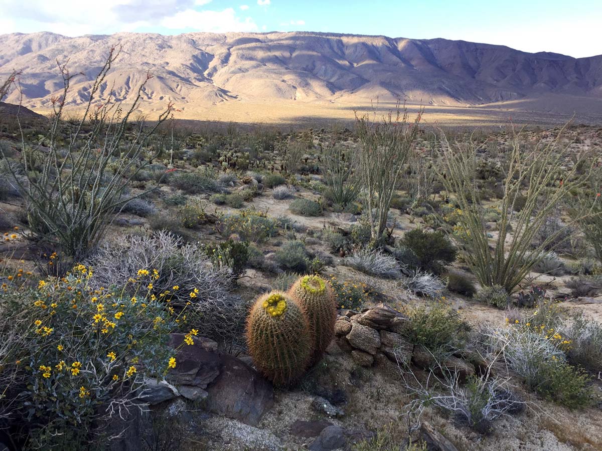 Fig. 13-15. This pediment surface is host to a cactus garden in Anza Borrego State Park, California. |
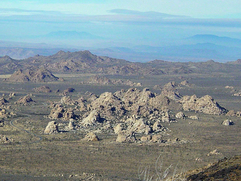 Fig. 13-16. Inselbergs of on a pediment surface in Joshua Tree National Park, California. These inselbergs are mostly remnants of granitic plutons. |
Spheroidal Granite Boulder PilesIn many desert regions where there is granitic bedrock (having a uniform texture and composition), weathering at or below the surface creates naturally rounded boulders. Weathering takes of the sharp edges created by intersecting fractures in the bedrock. Water and air seeps in along fractures and gradually degrades the granite into sandy sediment that easily washes away when infrequent rainstorms occur, leaving being stacks of granitic boulders (Figures 13-17 to 13-19). Grus is the name for grainy sand and fine gravel (sediments) derived from the weathering of granitic rocks, typically in arid or semiarid regions. |
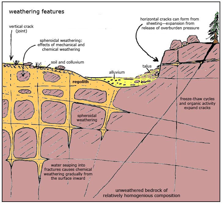 Fig. 13-17. Formation of spheroidal boulders by weathering and erosion of granite. |
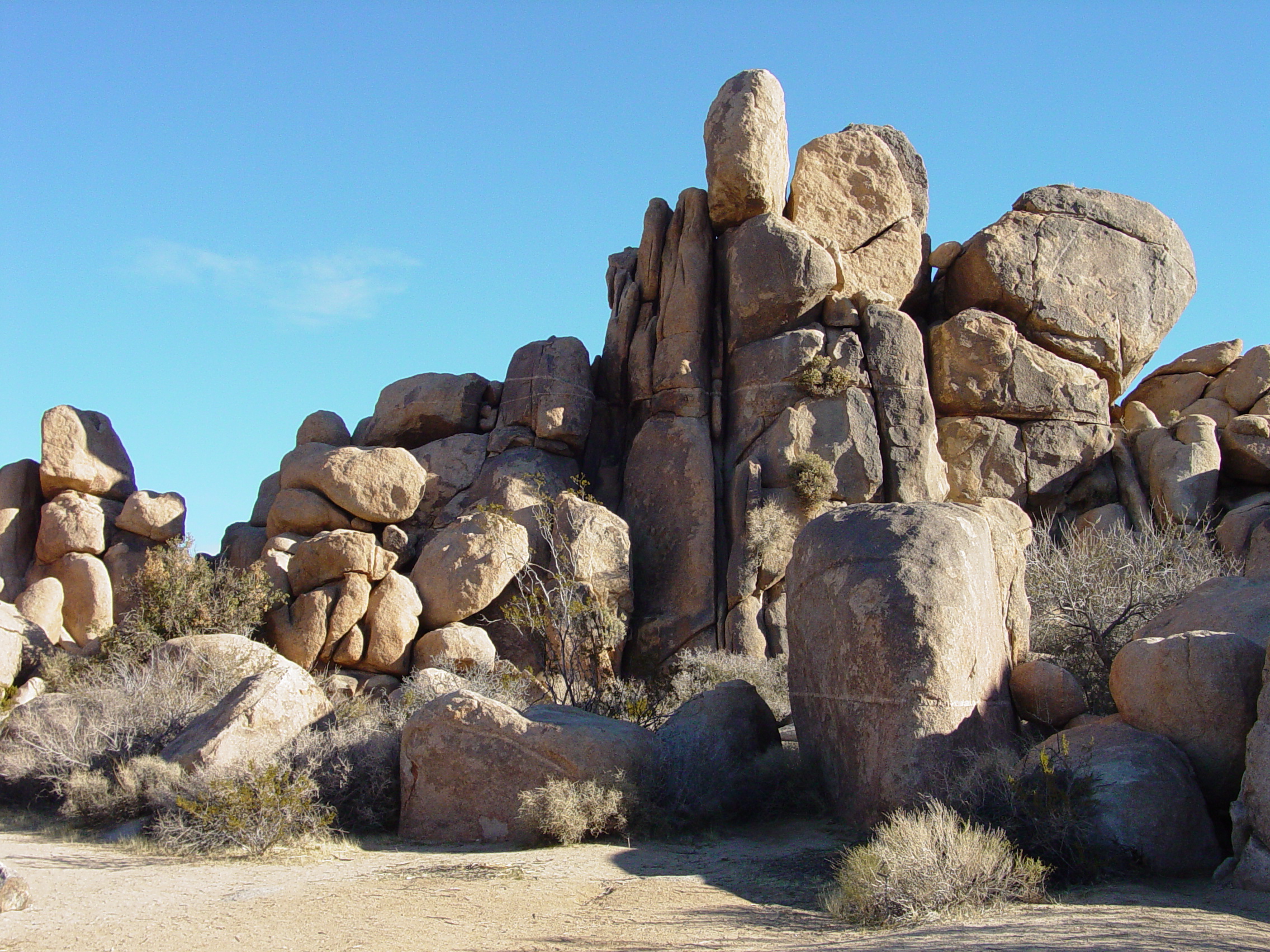 Fig. 13-18. Spheroidally weathered boulders, Quail Springs, Joshua Tree National Park, CA. It is easy to see the original joints in the bedrock where weathering occurred. |
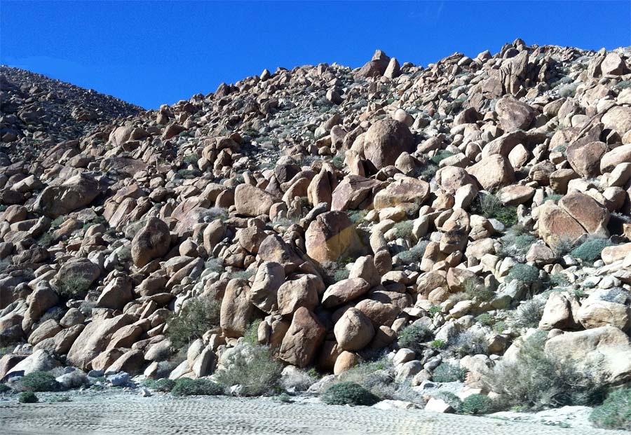 Fig. 13-19. Spheroidally weathered boulders along I-8 in eastern San Diego County, California. Whole mountainsides in this region are covered with nothing but boulders. |
Desert PavementIn many desert regions, the ground surface is covered by gravel-sized rock fragments. A desert pavement is a gravel layer that forms on the surface of many desert landscapes where the wind has removed finer materials (sand, silt, dust). Desert pavements are common on old pediment surfaces and are well developed on old alluvial fan surfaces that have not been disturbed by flash flood erosion for a long period of time (Figures 13-20 and 13-11). The gravel on the surface not only protects the finer material (below) from being eroded, but can actually trap dust which get washed by rain into the layer immediately below a layer of gravel on the surface. The rock fragments on the surface of a desert pavement typically have dull-dark appearance from being exposed to long periods of solar radiation. The rocks may also appear abraded by the wind into interesting shaped rocks called ventifacts. Sand and gravel on a desert surface can be moved and sorted by strong winds. In some desert settings, for centuries, dust devils have been constantly moving through on a nearly daily basis. Over time, this abrades the surface, removing dust and sand, concentrating gravel. |
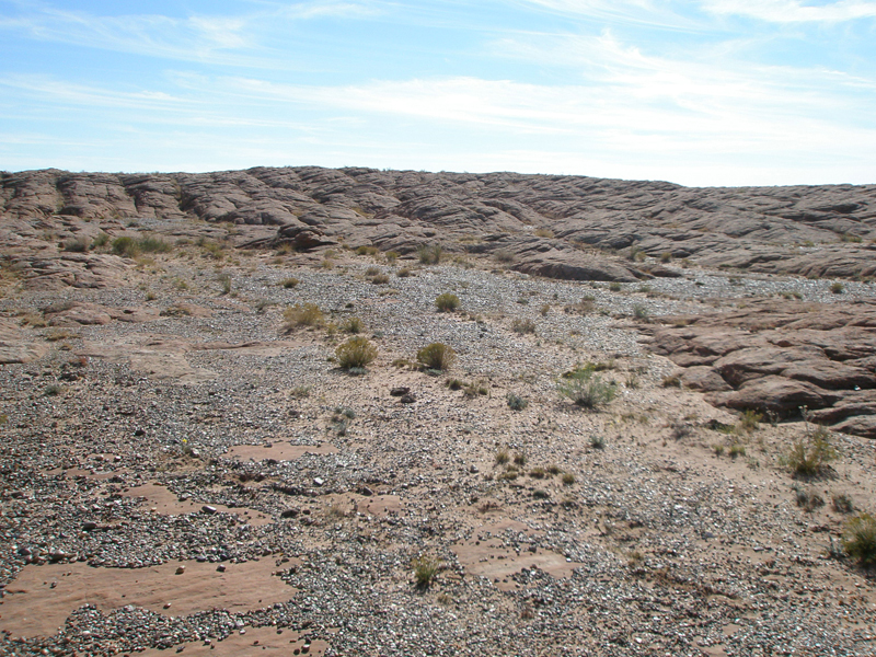 Fig. 13-20. A desert pavement of mostly gravel partly covers a pediment surface in Mojave National Preserve, California. Wind has stripped away finer sediments, leaving gravel behind. |
 Fig. 13-11. Close-up view of a desert pavement in the Mojave National Preserve, California. A layer of fine-silt rich (dust) or caliche typically underlies the surface gravel. |
|
Hour-Glass Canyons Along Mountain FrontsMountain fronts in desert regions frequently display and erosional pattern called hour-glass canyons. An hour-glass canyon is a drainage basin in a desert region that typically has a bowl-shaped upland region where headwater streams gather precipitation where it falls most intensely in upland regions. Coalescing stream carve bowl-shape headwater regions. As more stream merge to form a principle stream, the rate and intensity of erosion intensifies downslope, carving a deep, narrow confining canyon. Once the stream reaches the valley, the floodwaters slow down and drop their sediments, building up gently-sloped alluvial fans (Figures 13-22 to 13-23). Coarser sediments consisting of boulders, cobbles, gravel and sand locally fill pockets left behind on bedrock or a pediment surface along bifurcating stream channels associated with intermittent flood waters in the upper fan transition. |
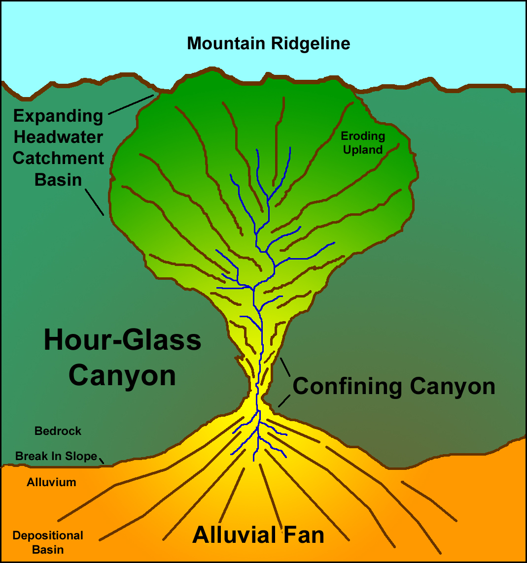 Fig. 13-22. Formation of an hour-glass canyon on a mountainside in a desert region. |
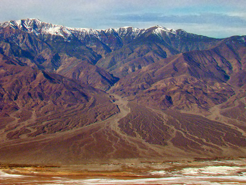 Fig. 13-23. Example of an hour-glass canyon and alluvial fan on the eastern flank of Telescope Peak in the Panamint Range (located on the west side of Death Valley, California). |
Desert Depositional EnvironmentsDespite arid conditions, flowing water is the main mechanism eroding, transporting and depositing sediments in desert environments. Throughout the western deserts of the United States, tectonic forces have created numerous mountain ranges and intervening valleys. Despite water being the dominant force of erosion, there is typically not enough water for streams to create rivers that can flow all the way to the oceans. In many places stream drain into internally drained basins where during wet periods, lakes form, but during dry periods of extended drought the lakes dry up forming playas (dry lake beds). With no place to go, sediments accumulate, slowly filling the low regions basins and along their margins as alluvial fans and bajadas (Figures 13-24 and 13-25). |
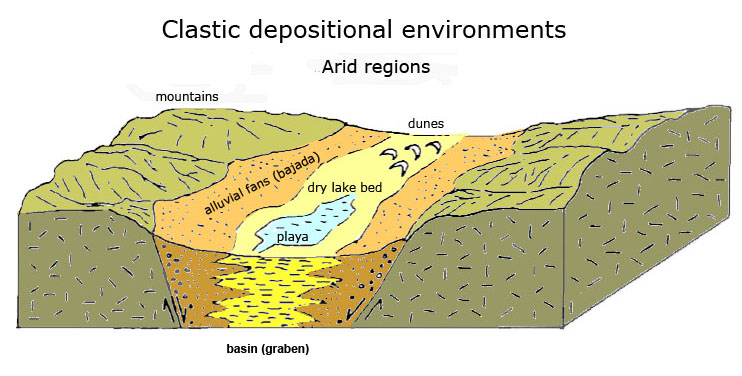 Fig. 13-24. Desert depositional environments in fault-bounded valleys typical of the deserts in the southwestern United States. |
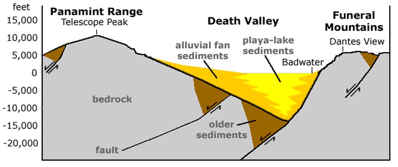 Fig. 13-25. Cross section of Death Valley show general thickness and character of sediments in the Death Valley basin between the Panamint Range and Funeral Mountains. |
Alluvial Fans and BajadasAn alluvial fan is an outspread, gently sloping mass of sediment deposited by a stream where it issues out of the mouth of a narrow canyon draining from an upland area. Viewed from above, an alluvial fan typically has the shape of an open fan with the apex being at the mouth of the canyon (Figures 13-26 and 13-27). Alluvial fans may merge together to form an apron-like slope along the base of a mountain front, forming a bajada. A bajada is an alluvial plain along the base of a mountain front formed from the accumulation and coalescing of alluvial fans.Alluvial fans are common in mountain basins settings in arid to semi-arid regions, but also occur covered with cactus forests, pine and oak scrub forests, and chaparral in upland regions in the California Coast Ranges and high deserts of the Mojave and Colorado Plateau. Fining of Sediments Down Slope On Alluvial FansThe character of sediments and plants they are host to change downslope form the mouth of a canyon to the toe of the fan. The sediment range increasing from very coarse to very fine grained the farther away form the source areas.Upper Alluvial Fan DepositsWhere a stream exits a canyon and dumps sediments onto an alluvial fan, the upland portion of the alluvial fan tends to consist mostly of a mix boulders, cobbles, and gravel. The upper part of alluvial fans are subject to debris flows or debris floods from infrequent thunderstorms or snow melt in adjacent highlands (example in Figure 13-28). Upper fan deposits are often bedded layers called fanglomerate. Fanglomerate consists of large angular fragments mixed with sand and silt deposited as layers from each flood event (Figure 13-29).Mid Alluvial Fan DepositsFarther from the mouth of the canyon, the size of the sediment fraction decreases in size as the sediment is distributed by migrating braided channels that spread over an increasingly large area with a increasingly gentle slope profile. In regions with granite bedrock, coarse-grained arkosic sand (rich in feldspar grains) form a weathered, coarse-grained sand alluvial sediment called grus (Figure 13-30).Lower Alluvial Fan DepositsThe toe region of alluvial fans are typically dominated by finer-grained sediments (sand and mud) (Figure 13-31). The toe of an alluvial fan may merge with a trunk stream (a principle stream draining through a valley) of may merge directly with an ephemeral lake bed (called a playa) filling the lowest part of a valley where the finest-grained materials (fine sand silts and clays), and salts are deposited. These fine grained deposits are in many places eroded heavily by winds and are carried away to nearby dune fields or a dust storms that can travel long distances. The toe of an alluvial fan typically drains into a trunk stream which carries water (rarely) down stream into dry lake bed basins or regional drainages. |
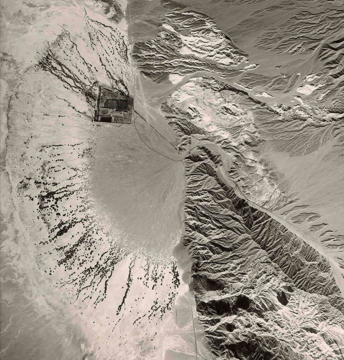 Fig. 13-26. Furnace Creek alluvial fan in Death Valley National Park, California. Plants highlight lower fan channels. 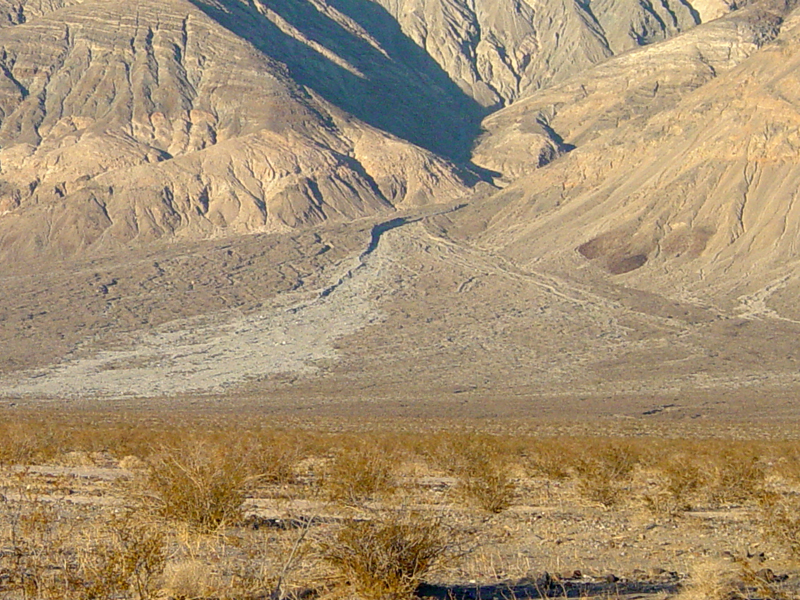 Fig. 13-28. Alluvial fan with a recent large debris flow deposit, Panamint Valley in Death Valley National Park, California.  Fig. 13-30. Mid fan deposits are mostly granitic sand (grus) deposits in Anza Borrego State Park, California. |
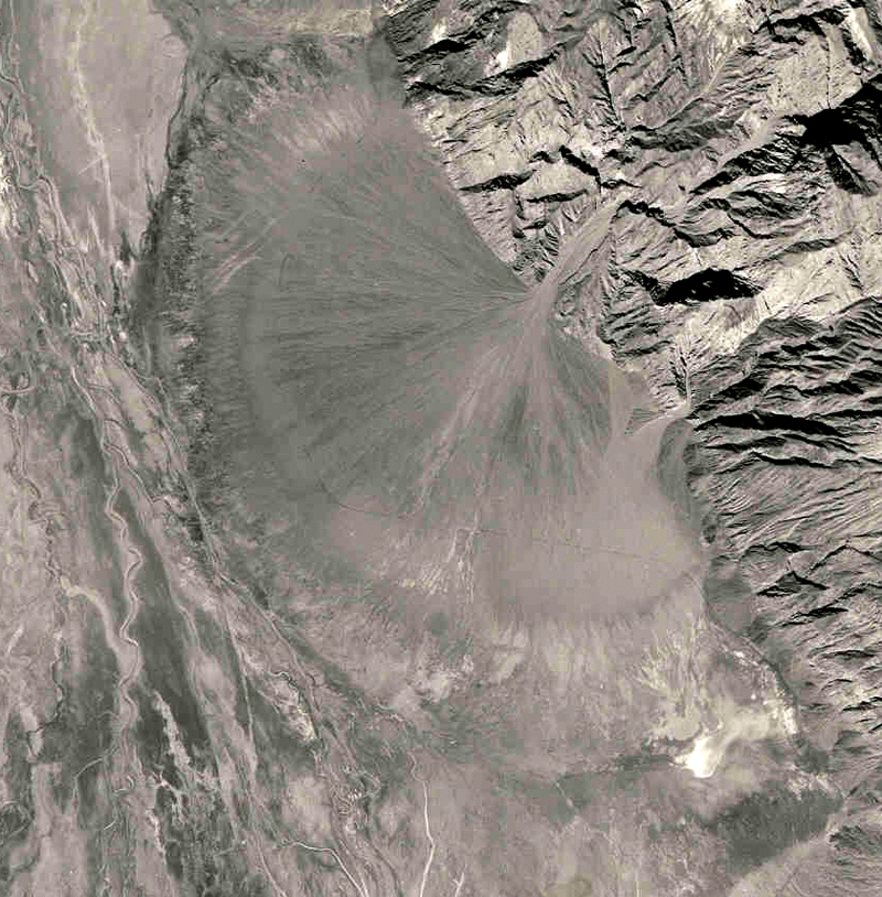 Fig. 13-27. Copper Canyon Fan, a large alluvial fan grades into a trunk stream and playa deposits in Death Valley National Park, California.  Figure 13-29. layered beds of coarse-grained sediments of an upper alluvial fan deposit showing bedding from intermittent storm events. 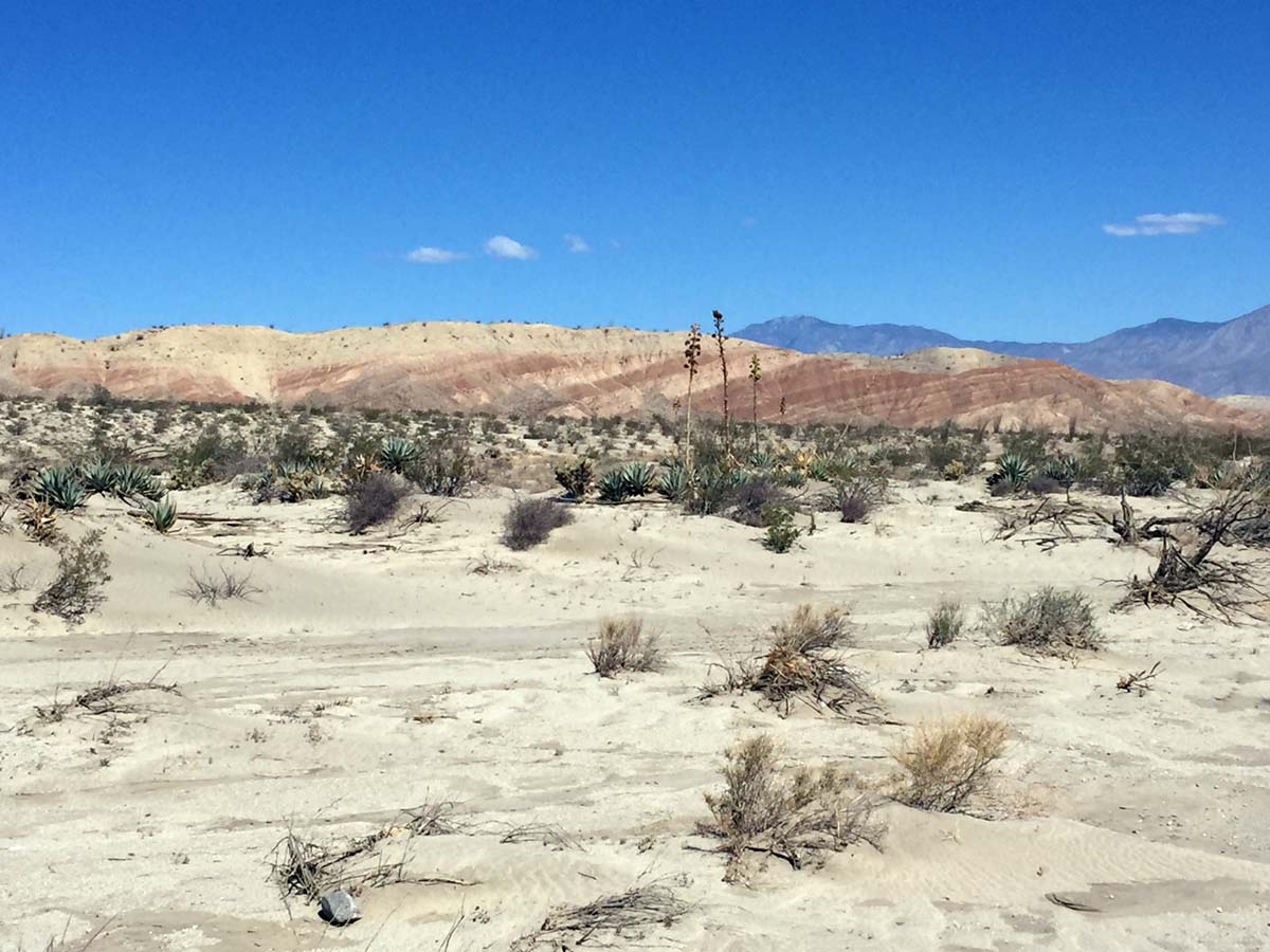 Fig. 13-31. Lower alluvial fan deposits is mostly fine sand and silt, Anza Borrego State Park, California. Fig. 13-31. Lower alluvial fan deposits is mostly fine sand and silt, Anza Borrego State Park, California. |
|
Caliche and Hard PansCaliche is a hardened zone in soils and surficial deposits found in semiarid regions where of calcium carbonate and possibly other carbonates, clay minerals, or crystalline salts such as gypsum (CaSO4), halite (sodium chloride), sodium nitrate, and other salts impregnated the pore spaces in the sediment or soil.Caliche forms surfaces called hard pans. A hard pan is a tightly cemented sedimentary crust that can accumulate to form rock-hard layers that can prevent water from seeping into the ground. It can also hinder plants from getting roots established. Because it is a hard crust, it often forms caprocks to low mesas or stream terraces on old, incised pediments or along arroyos eroded into old alluvial fans (Figures 13-32 and 13-33). |
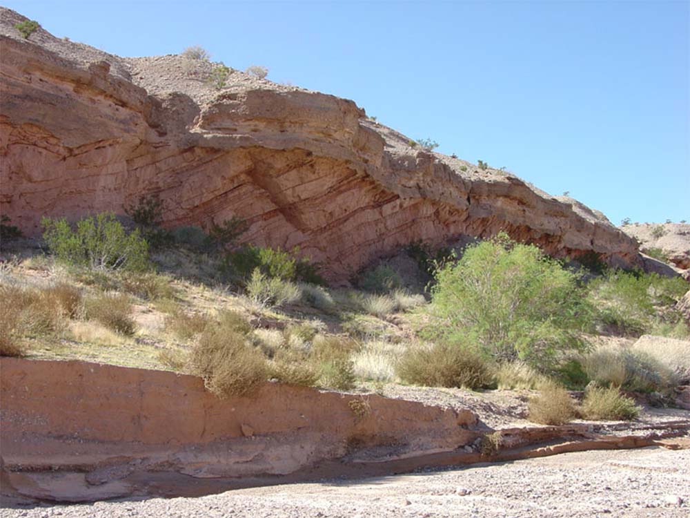 Fig. 13-32. A hard crust of caliche forms the caprock of a surface along an incised stream channel in Lake Mead National Recreation Area, Nevada. Fig. 13-32. A hard crust of caliche forms the caprock of a surface along an incised stream channel in Lake Mead National Recreation Area, Nevada. |
 Fig. 13-33. Layers of caliche create hard caprocks on low mesa along arroyos in the Mojave National Preserve, California. |
Salt Lakes, Salt Pans, and PlayasA playa is an ephemeral (intermittently flooded) lake bed that occupies the lowest part of a internally drained, isolated valley in an arid or semiarid region. Many playas in desert regions are also "salt pans" (Figures 13-34 to 13-36).A salt pan is a shallow basin, usually in a desert region, containing salt, gypsum, sodium carbonate, or other evaporite minerals that was deposited from an evaporated salt lake (playa) setting. Salt pans form in valleys where there is no external drainage. The Bonnieville Salt Flats on the west side of the Great Salt Lake is an example of an extensive salt pan. |
 Fig. 13-34. Racetrack Playa in Death Valley National Park California is surrounded by alluvial fans (a bajada). |
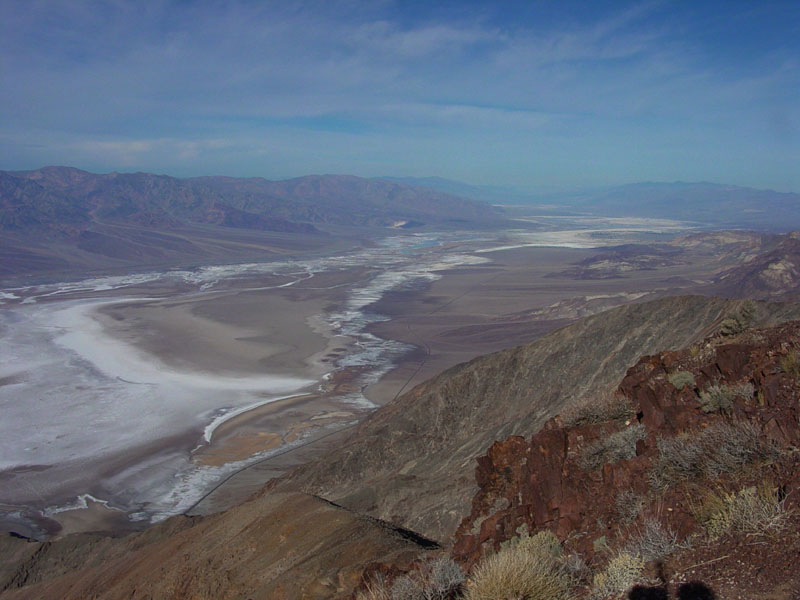 Fig. 13-35. Death Valley's playa is a salt pan in the lowest part of Death Valley National Park, California |
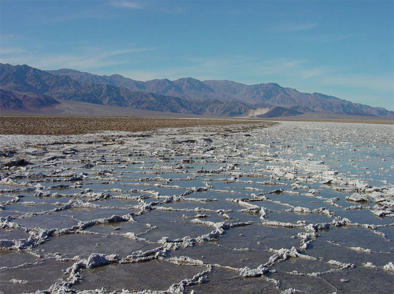 Fig. 13-36. Death Valley playa (salt pan) showing salt polygons forming along the principle stream in the valley. |
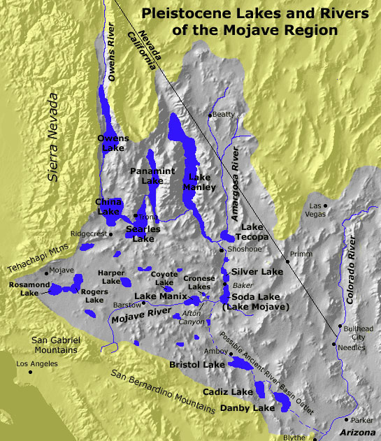 Fig. 13-37. Ancient lakes of the Mojave Desert region. Lakes formed during wet periods associated with ice ages, flooding structural basins in the Great Basin region. |
Ancient Lakes in Desert RegionsDuring the last glaciation period, lakes filled many of the valleys in the western United States. Figure 12-37 shows locations of many of the ancestral lakes that existed in the greater Mojave Desert region during the ice ages when California was a wetter and cooler region. Through the Holocene Epoch, the climate got warmer and drier, and all the lakes eventually dried up. These low areas still become flooded during wet periods, but they typically completely dry up during drought periods, leaving behind crusty layers of salty, fine-grained sediments on their surfaces. At the peak of the last ice age, Ancient Lake Manly flooded Death Valley to as much as 800 feet deep (Figure 13-38). Death Valley is now one of the hottest and driest locations on planet Earth! |
 Fig.13-38. Shoreline Butte in southern Death Valley preserves wave-cut terraces from ancient Lake Manly that once flooded the valley to depths as much as 800 feet. |
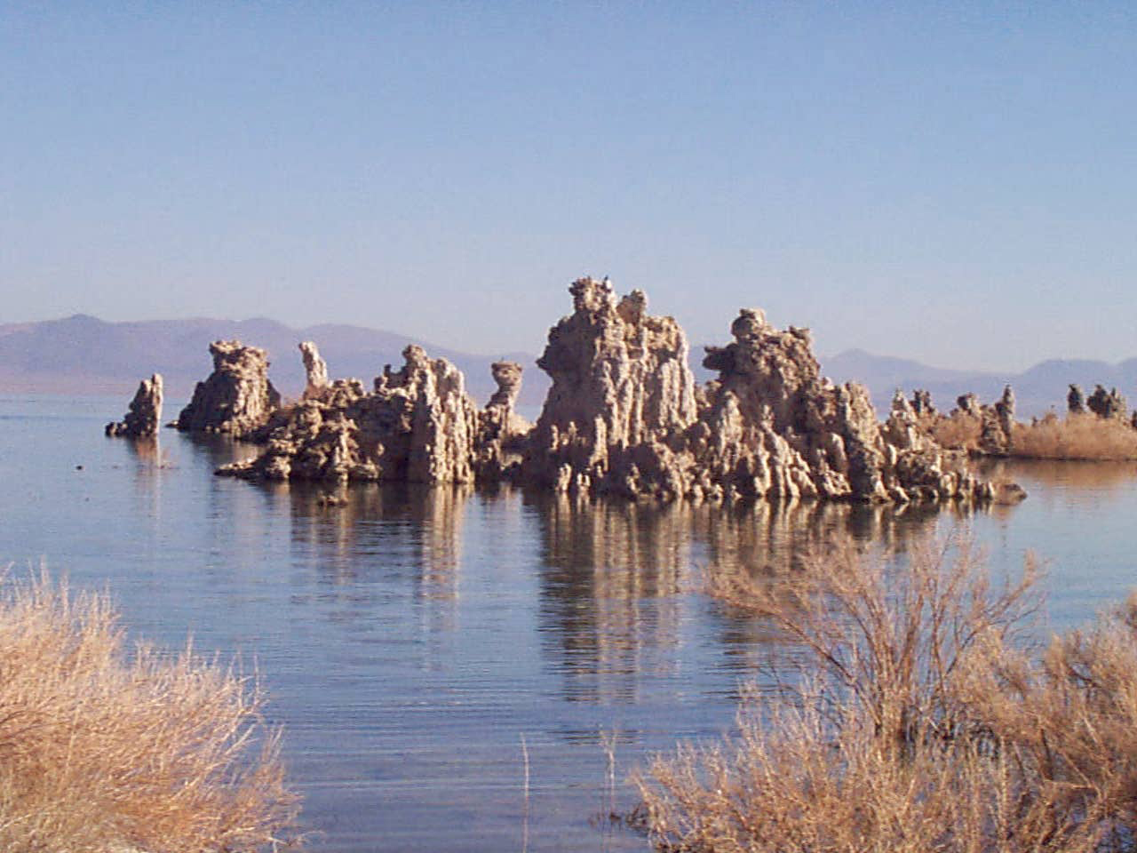 Fig. 13-39. Tufa towers are spring deposits of limestone composition in Mono Lake, a large salt lake on the east side of the Sierra Nevada Range in California |
| Since the end of the last ice age the climate of the Desert Southwest has changed significantly. At the peak of the last ice age, cool and wet conditions in the Southwest caused precipitation to accumulate in the isolated basins with the Basin and Range region. Today, Mono Lake (in California) and the Great Salt Lake (in Utah) are remnants of much larger ancient lakes, and are are now much saltier than ocean seawater (Figure 13-39). The Great Salt Lake is a small remnant of the much greater ancient Lake Bonneville (now home to the Bonneville Salt Flats in western Utah). Ancient Lake Lahontan flooded much of the Great Basin region throughout northwestern Nevada and parts of northern California and Oregon. | |||
Desert OasesAn oasis is an isolated source of water in a desert, typically a pond or small lake that is fed by local springs or upwelling groundwater, and occasional storm runoff. They may be the only source of freshwater in a large region, and are essential to supporting desert wildlife (Figure 13-40).Oasis are rare in the Desert Southwest of the United States. Fossil and archaeological evidence shows that ancient lakes in the Southwest supported an abundance of wildlife and even some early human populations. As the climate changed, dryer conditions prevails, the lakes dried up by mid Holocene time, and the ecosystems changed, driving many species to extinction. In a rare case, remnant species of desert pupfish can still be found in isolated ephemeral streams and oasis to which they are adapted. They are remnant species left over from the periods when great lakes and streams in the region were interconnected, but are now isolated basins. |
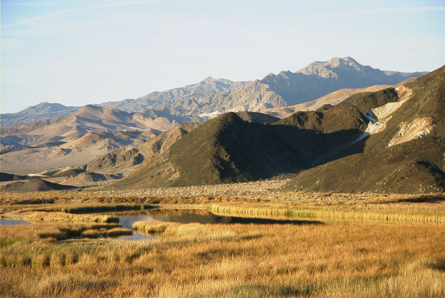 Fig. 13-40. Saratoga Springs oasis in southern Death Valley National Park, California |
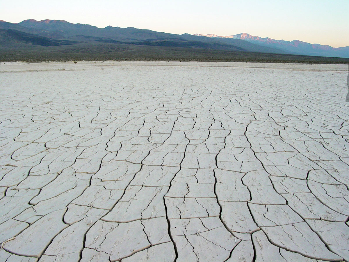
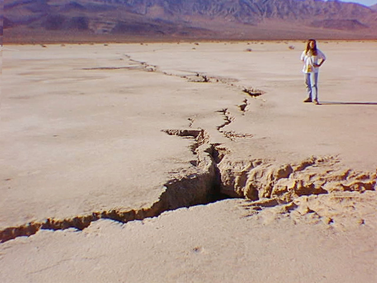
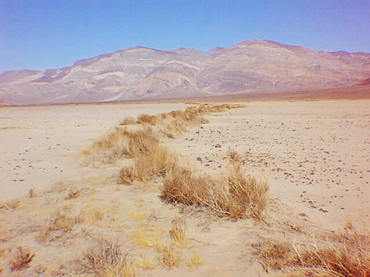
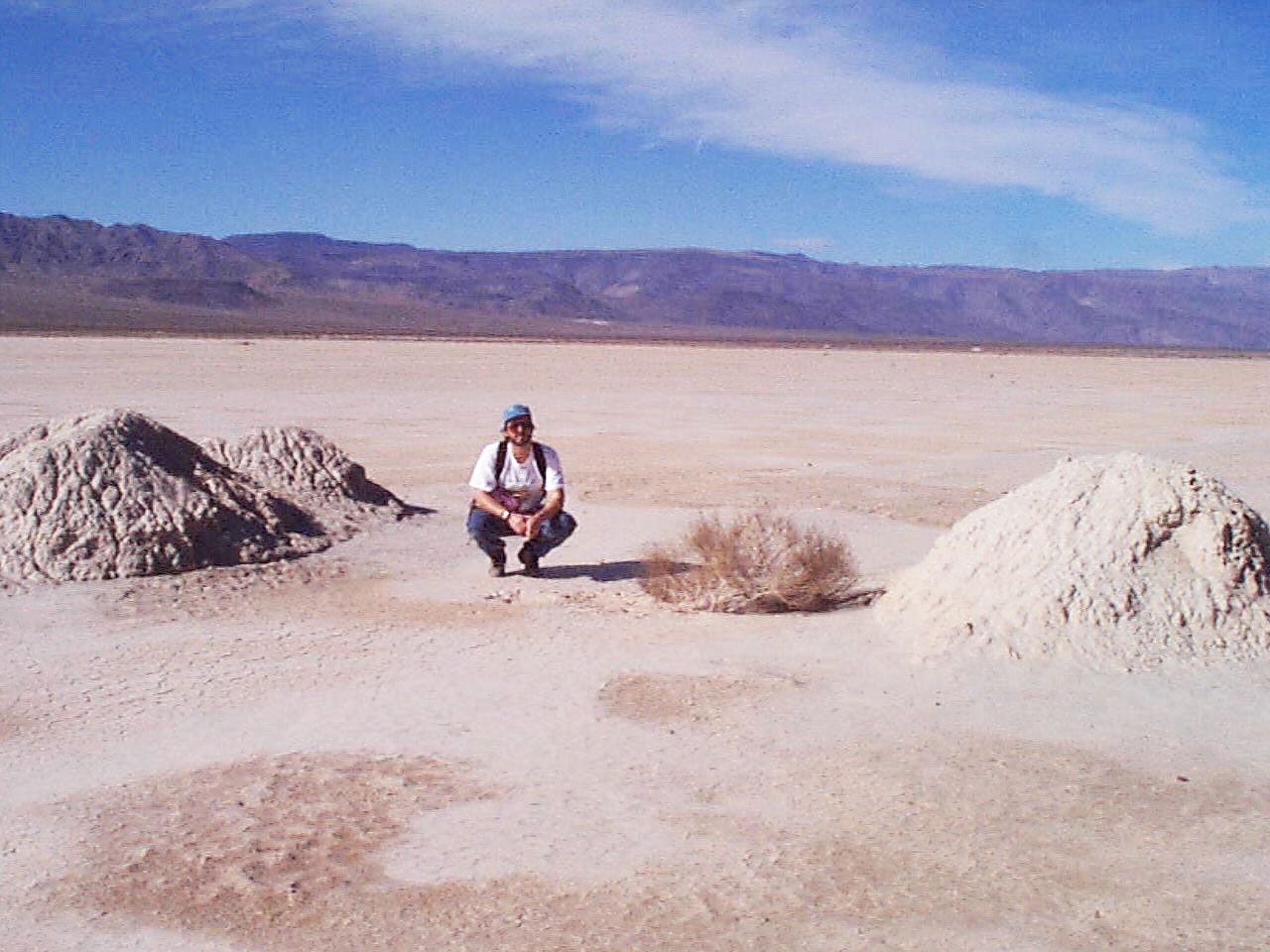
Panamint Valley - A Dynamic Desert BasinPanamint Valley is a very geological active region on many levels. The mountains are still tectonically rising relative to the valley. During the peak of the last ice age, Panamint Valley was filled with a great lake, a part of the greater drainage system that ultimately drained into Death Valley. After the ice age, the lake slowly dried up as alluvial fans built up from the mountain ranges surrounding the basin (Figure 13-41). The dry-lake bed (Panamint Playa) is occasionally flooded by infrequent storm drainage from the surrounding mountains.Panamint Dunes is a relatively small dune field at the north end of Panamint Valley (Figure 13-42). Wind blows north through the valley, moving fine-grained sediments from the playa and surrounding alluvial fans. The wind is forced to rise over the mountains at the north end of the valley. The dust (silt and clay) is carried away, but the sand is too heavy, and accumulates on the dune field. The dune field has only accumulated since the end of the last ice age. Panamint Playa is undergoing desiccation (drying out). The surface of the playa shows a variety of desiccation features. Small mudcracks in the shallow surface deposits display mudcracks associate with the drying-out of clay-rich sediments that are load with expanding-clays minerals that tend to shrink when they dry out, and expand when they get wet (Figure 13-43). Giant fissures are also forming on the playa due to the drying out of the sediments at depth. The fissures extend an undetermined depth, possibly dozens of meters, into the ancient lake-bed deposits beneath the playa. As the playa dries out (on the surface and underground), large fissures have been forming, forming a large system of fissure running across the play (Figure 13-44). When floods occur, these large fissures become traps and conduits for water draining onto the playa. The fissures temporarily become temporary reservoirs of water and soil moisture, allowing plants to grow. The established plants, mostly grasses and small desert plants that grow and create wind breaks that trap sediments that eventually fill in the fissures (Figure 13-45). Eventually the fissures and the plants disappear from the surface, but old fissures remain active below the surface. During wet periods, precipitation from the surrounding uplands drains into the alluvial fans, some of the water finds its way into the underground fissure system, creating artesian water pressure to build up. On many locations across the playa, small mud volcanoes temporarily form from the artesian effect, creating small spring mounds (Figure 13-46). Similar features can be found on many playas elsewhere western United States. |
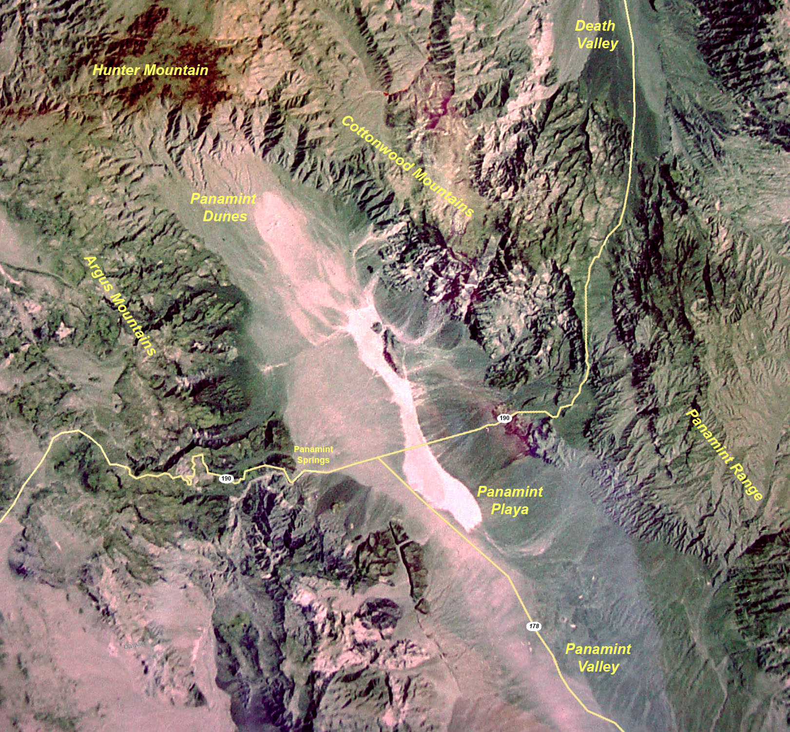 Fig. 13-41. Satellite view of Panamint Valley, located in Death Valley National Park, California. Features to note are Panamint Valley's playa, alluvial fans, and dune field at the north end of the valley. 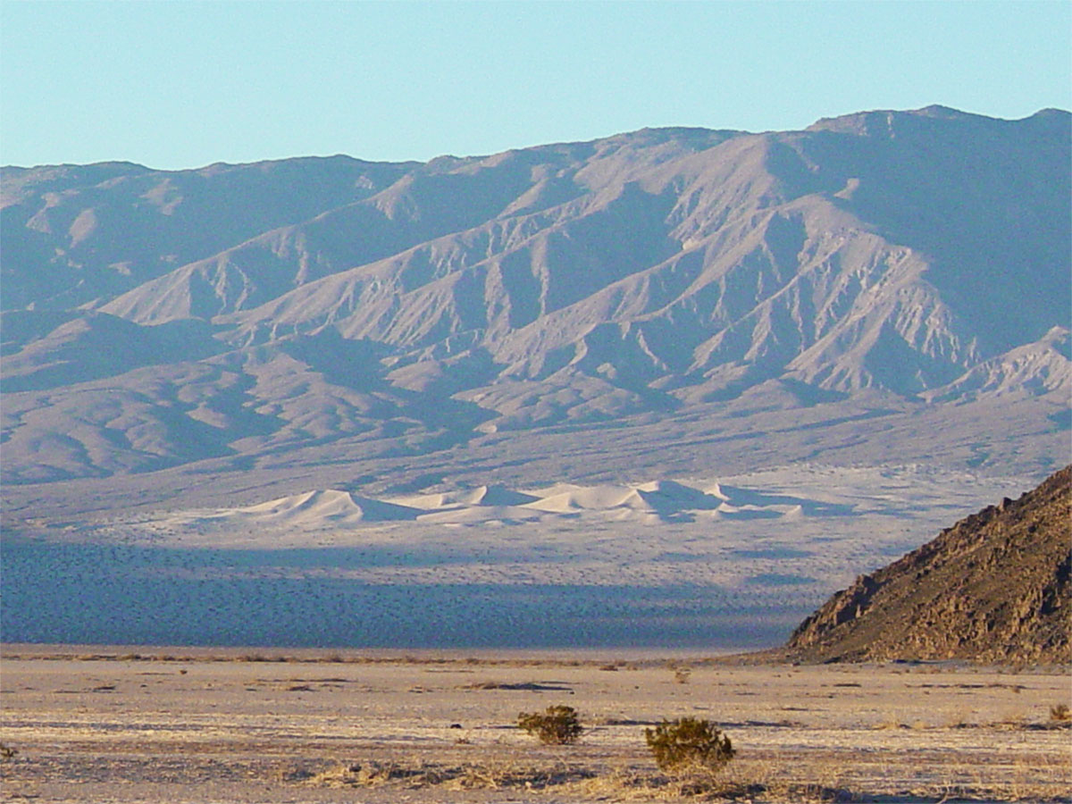 Fig. 13-42. Panamint Dunes on an alluvial fan at the north end of Panamint Valley. |
||||
|
|||||
The Sliding Rocks of Racetrack Playa, Death Valley, CaliforniaPerhaps one of the most unusual phenomena related to desert processes involving wind are the Sliding Rocks of the Racetrack Playa (in Death Valley National Park, CA, Figure 13-47 and 13-48). Hundred of cobble to boulder-sized rocks have been observed leaving trails of where they have slid across the surface of this remote playa. The rocks slide on a rain-slickened surface, sometime embedded in thin ice sheets that is moved by the wind, dragging rocks along with them and leaving trails. Other times, hurricane-force winds and strong dust may be capable of the moving rocks. Most of the trails follow the prevailing wind direction.Ice may be nice for sliding rocks on a slippery surface, like on a high desert mountain playa after a winter storm. However, anyone who has experience a major tornado can tell you that tornadic winds can move just about any object, even a rock, with or without ice. |
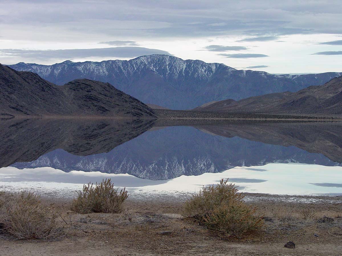 Fig. 13-47. The Racetrack Playa with a thin layer of water on the ephemeral lake bed, Death Valley National Park California. |
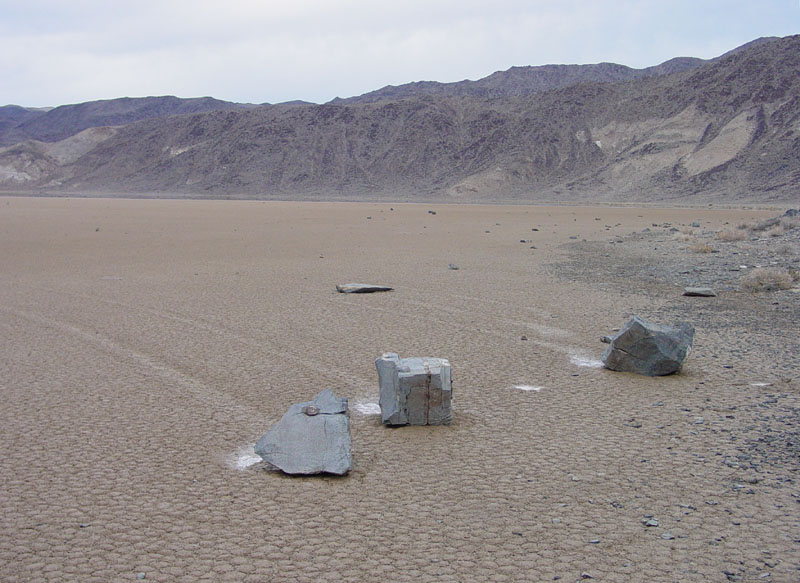 Fig. 13-48. Sliding rocks with trails on Racetrack Playa located in a remote area of Death Valley National Park, California |
How does wind erode and transport materials?Wind in arid regions lifts and carries away dust-sized particles. Sand grains are carried in the bed load moving by rolling and bouncing along the surface (a process called saltation). Finer silt and dust can be taken airborne and blow long distances away (Figure 13-49 and Figure 13-50).Abrasion is the process of wearing down or rubbing away by means of friction, typically by wind-blown dust or sand. Deflation is the removal of particles of rock, sand, soil or dust, by the wind, often leaving a rocky crust (a desert pavement) on a desert landscape. Dunes and Sediments Deposited By the WindA dune is an accumulation of wind-blown sand and/or silt found in association with deserts or sandy beach settings where there is a constant supply of silt to sand grain-sized sediments. A collection of dunes is called a dune field (Figures 13-51 and 13-52). Dune fields typically occur in the down-wind end of a valley where winds slow down or are unable to lift fine-grained materials over a barrier, such as an adjacent mountain range. A star dune is typically the highest dune in a dune field. Star dunes typically have three or four arms radiating from its usually higher center so that it resembles a star in shape. Star dunes form when winds blow from three or four directions, or when the wind direction shifts frequently or changes with the seasons. Extensive dune fields cover large portions of the Sahara Desert and Arabian Peninsula and other desert regions of the world. |
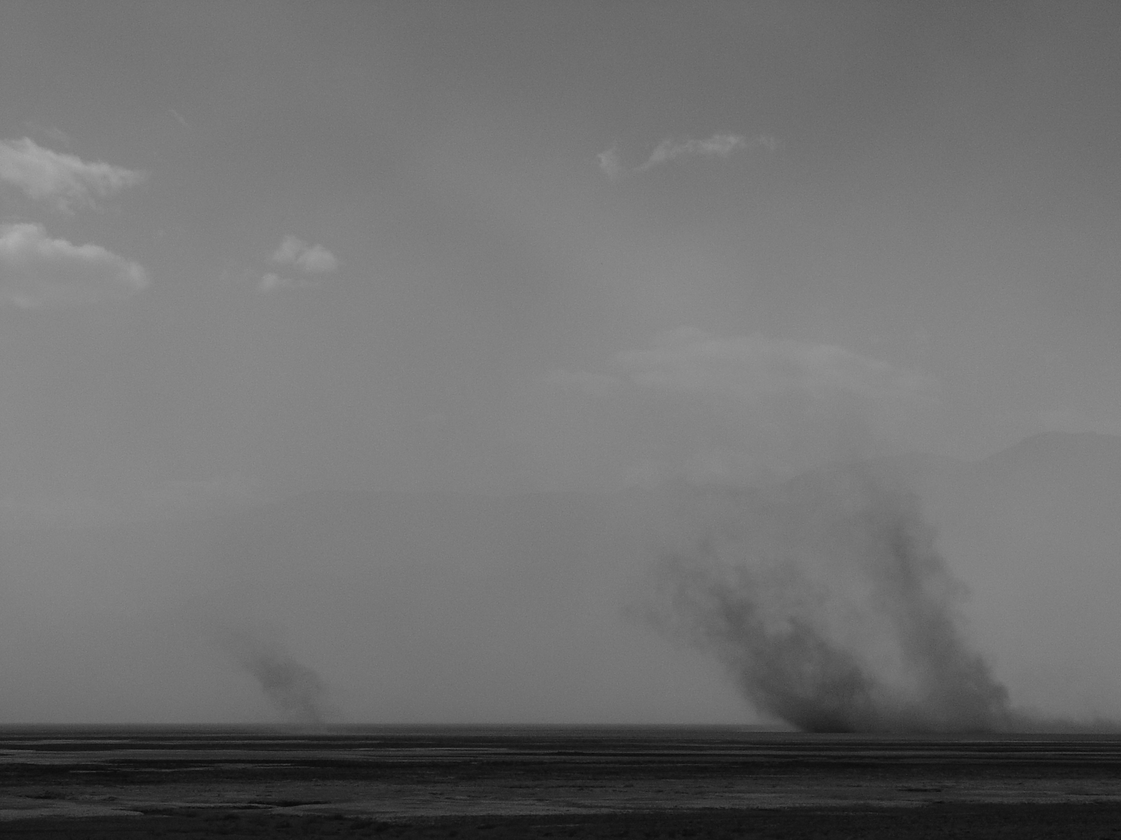 Fig. 13-49. Dust devils lift and carry away silt and dust as shown here in Death Valley National Park, California 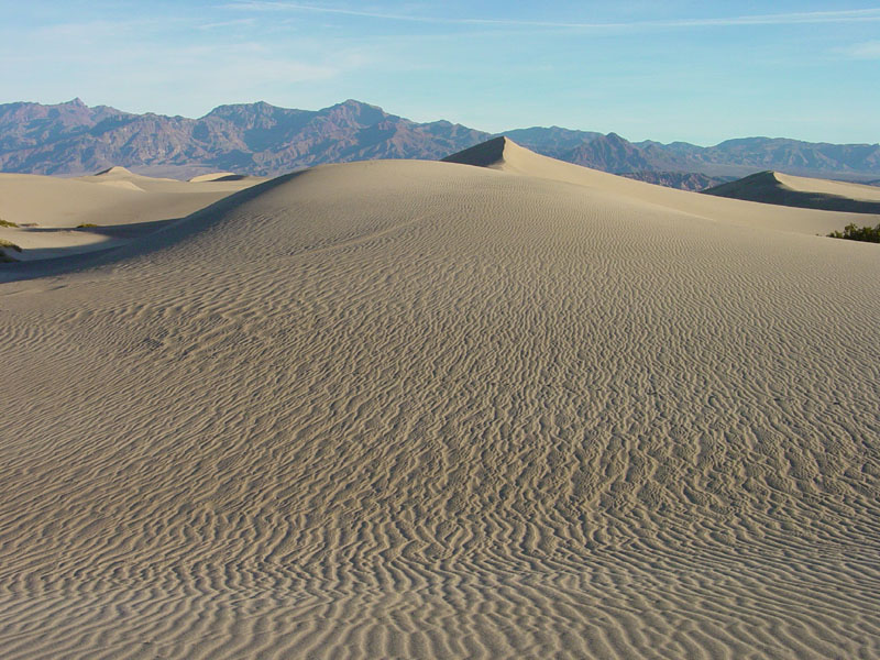 Fig. 13-51. Sand dunes with ripple bedding, near Stovepipe Wells, Death Valley National Park |
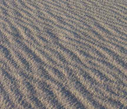 Fig. 13-50. Ripples in wind-blown sand, Death Valley National Park are created as sand migrates by saltation. 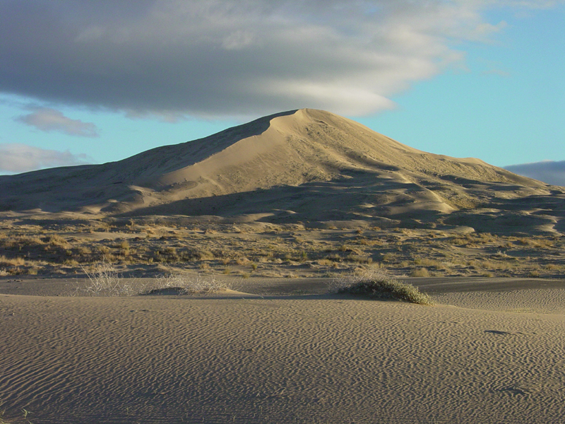 Fig. 13-52. Star dune in Kelso Dunes in the Mojave National Reserve, California |
Wind AbrasionIn some desert regions, it may be years between significant rainfall events. However, in many of these locations the wind can dominate processes moving fine-grained sediments. Sand particles carried in the wind will wear away at outcrops creating unusual landscapes. Over time, exposed rock in desert environments can take on an wind-abraded appearance (Figures 13-53 and 13-54).Pebbles, cobbles, and boulders too heavy to be moved by the wind accumulate on the land surface forming desert pavements (discussed above). A ventifact is a stone on the surface in a desert environment that is unusually shaped, abraded by wind-blown sediment. Markings on ventifacts typically reflect seasonal prevailing wind patterns (Figure 13-55). |
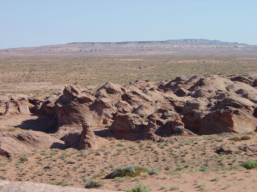 Fig. 13-53.Wind Abrasion |
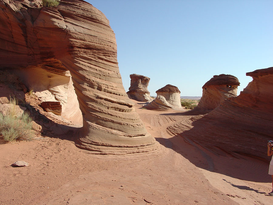 Fig. 13-54. Wind-abraded outcrops of Navajo Sandstone near Tuba City, Arizona |
 Fig. 13-55. Ventifacts (wind abraded cobbles) from Panamint Valley, California |
LoessLoess is a tan, buff to gray windblown deposit of fine-grained, loamy, calcareous silt or clay; fine-grained deposits typically derived from glacial outwash plains or dust derived from arid regions. Loess deposits blanket large regions of the northern Great Plains and the Midwest (Figure 13-56).The Sand Hills region of western Nebraska is an ancient dune field that is now covered with prairie grasses. The Sand Hills cover thousands of square miles and consist of stabilized dunes several hundred feet high in some locations. The dunes form from wind blowing away massive volumes silt from extensive outwash plains that existed south of the continental ice sheets that extended south into the Missouri and Mississippi valleys during the last ice ages. Concern exists that the dune fields could become reactivated is climate change brings increase arid conditions to the region. |
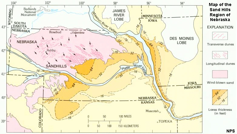 Fig. 13-56. Map showing the Sand Hills region of Nebraska. The region was an extensive dune field currently stabilized by grasses. |
Desert VarnishDesert varnish is a dark, hard film (or patina) of metal oxides formed on exposed rock surfaces in arid regions (Figure 13-57). In many places the metal oxides layers are most obviously deposited by a thin films of rainwater streaming down cliff surfaces, but in other locations they may be related to films associated with microbial activity and possibly metals deposited directly from the air. Desert varnish layers are typically a few millimeters thick, or less. Evaluation of prehistoric Indian petroglyphs carved into desert varnish show that the layers form very slowly over time. Figure 13-58 shows a collection of petroglyphs on "Newspaper Rock" (Utah). More recent petroglyphs (including an Indian riding on a horse) are light colored, but more ancient images, probably carved thousands of years ago, are darker from a new layer of desert varnish (patina) becoming re-established on the rock surface. |
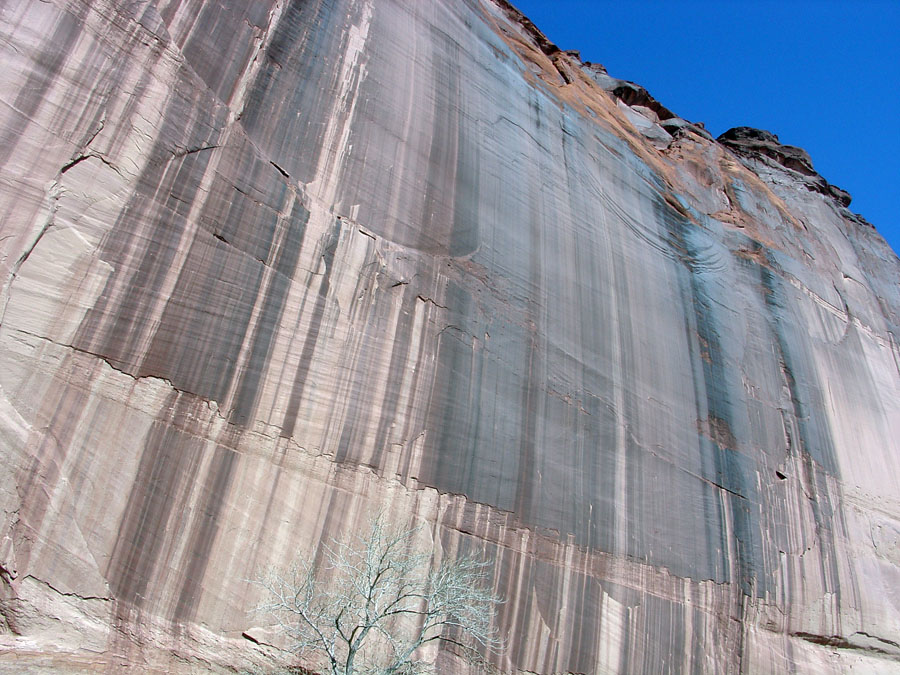 Fig. 13-57. Desert varnish on a sandstone cliff. Canyon de Chelley National Monument, Arizona. |
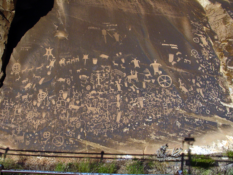 Fig. 13-58. Prehistoric Indian petroglyphs carved in desert varnish, Newspaper Rock, Utah. |
Deserts and semiarid regions of North America (and Hawaii)Arid and semi-arid regions dominate the landscape of the western United States. (Figure 13-59). Each of the desert regions have unique climate and geologic characteristics. Figures 13-54 to 13-61 illustrate each of the desert regions, showing select indicator plants that are uniquely adapted to the prevailing climate conditions in the region. |
| Chihuanhuan Desert—North America's largest desert, considered a rainshadow desert on the east side of the Sierra Madre (the mountain range of central Mexico. Extends from near Mexico City northward into west Texas and New Mexico (Figure 13-60). Sonoran Desert—a desert with a unique ecosystem that covers large parts of the Southwestern United States in Arizona and California, and Northwest Mexico in Sonora and Baja California, best know for its Saguaro and Organ Pipe Cactus, generally a frost free region (Figure 13-61). Mojave Desert—a high desert region located in southern California and parts of southern Nevada, southwestern Utah and northwestern Arizona. It is a region with Basin and Range topography (Figure 13-62). Colorado Desert—western part of the Sonoran Desert, located in low elevations along the lower Colorado River and southern California encompassing the Salton Sea region in California (Figure 13-63). Colorado Plateau—high, semi-arid region between the Great Basin and the Rocky Mountains in the 4 Corners region (Colorado, Utah, Arizona, and New Mexico. Much of the region is covered with pinyon pine and juniper shrub forests (Figure 13-64). Great Basin—low to high, semi-arid basins and region mountainous regions of Nevada and Arizona. Lowlands are typically grasslands and some playas between sagebrush and pine-covered uplands (Figure 13-65) Great Plains—high, semi-arid grasslands (steppe) region in the rainshadow east of the Rocky Mountains extending from central Canada to central Texas (Figure 13-66). Hawaii Rainshadow Arid Regions—on the leeward (downwind) side of the larger Hawaiian Islands arid to semiarid conditions prevail. The largest arid region is the Kao Desert in the rainshadow region of Mauna Loa, Hawaii's largest volcano (Figure 13-67). |
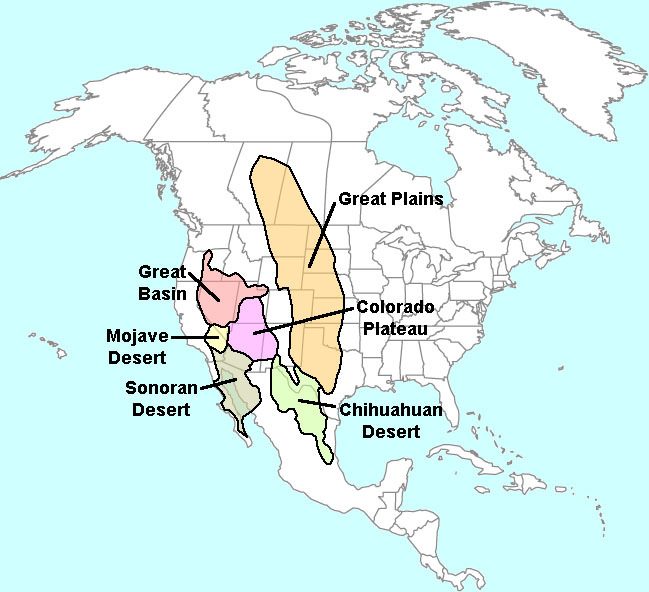 Fig. 13-59. Deserts of North America |
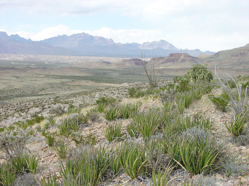 Fig. 13-60. Chihuanhuan Desert (North America's largest desert)(with Lechuguilla, an indicator plant) |
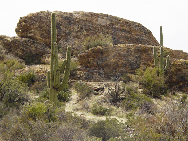 Fig. 13-61. Sonoran Desert (with Saguaro cactus) |
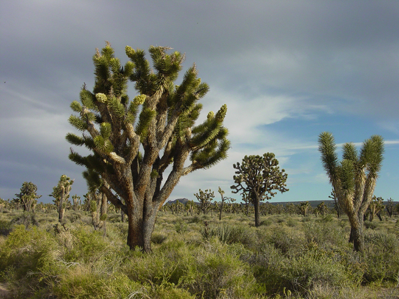 Fig. 13-62. Mojave Desert (with Joshua Trees) |
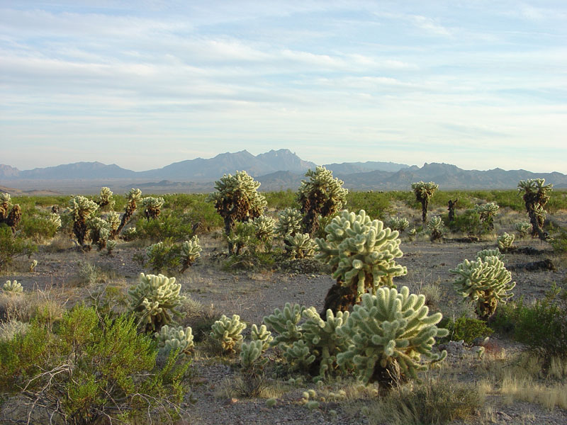 Fig. 13-63. Colorado Desert (with Teddy-bear Cholla cactus) |
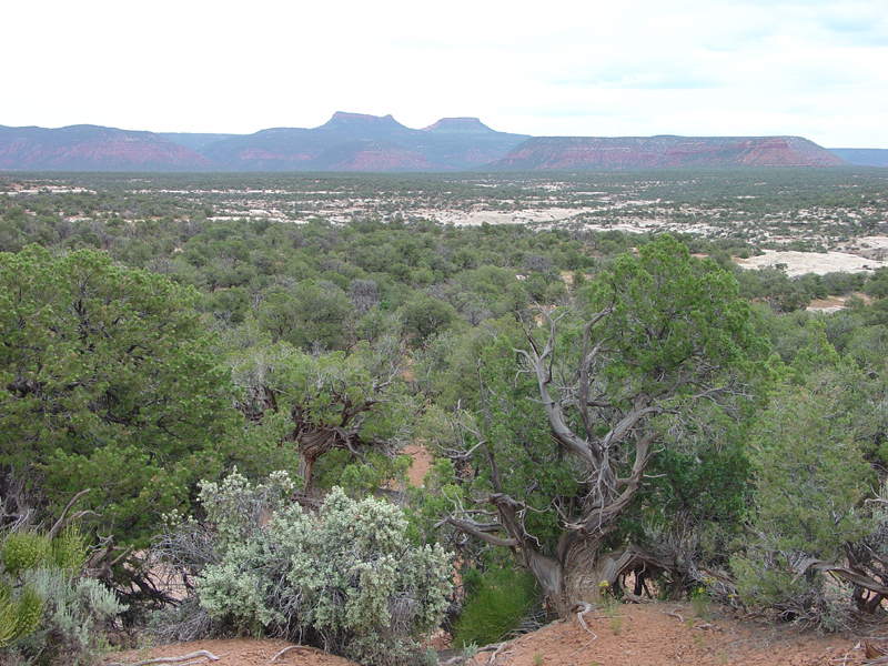 Fig. 13-64. Colorado Plateau (with Pinyon Pine-Juniper shrub forest) |
|
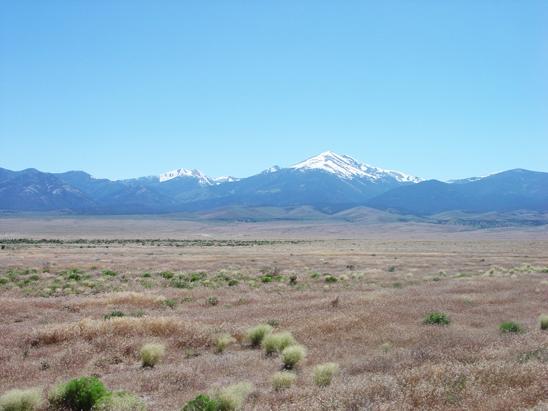 Fig. 13-65. Great Basin (grasslands with Basin and Range topography, forested mountains) |
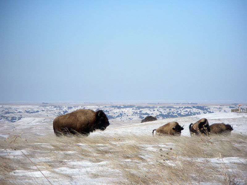 Fig. 13-66. Great Plains (grasslands in the rainshadow of the Rocky Mountains) |
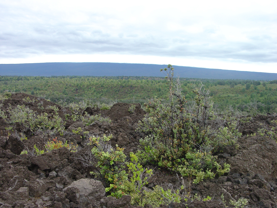 Fig. 13-67. The Kao Desert is in the rainshadow region of Mauna Loa volcano on Hawaii. |
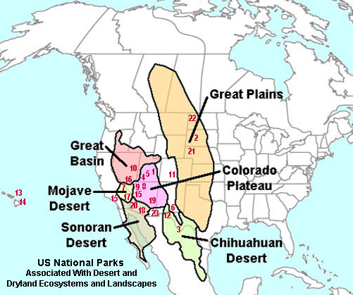
Parks Associated With Desert and Dryland Ecosystems and Landscapes |
|
| Arches National Park, UT (Colorado Plateau) -1 Badlands National Park, SD (Great Plains) - 2 Big Bend National Park , TX (Chihuahuan Desert) - 3 Capital Reef National Park, UT (Colorado Plateau) - 4 Canyonlands National Park, UT (Colorado Plateau) - 5 Carlsbad Caverns National Park, NM (Chihuahuan Desert) - 6 Death Valley National Park CA (Great Basin and Mojave Deserts) - 7 Glen Canyon National Recreation Area, UT,AZ (Colorado Plateau) - 8 Grand Canyon National Park, AZ (Sonoran, Mojave, Colorado P.) - 9 Great Basin National Park, NV(Great Basin) - 10 Great Sand Dunes National Park & Preserve, CO - 11 Guadalupe Mountains National Park, TX (Permian) - 12 Haleakala National Park, HI - 7 (Maui Silverswords) - 13 Hawaii Volcanoes National Park, HI - 8 (Kao Desert, Big Island) - 14 Joshua Tree National Park, CA (Mojave Desert) - 15 Lake Mead National Recreation Area, AZ (Sonoran, Mojave) - 16 Mojave National Preserve, CA (Mojave Desert) - 17 Organ Pipe Cactus National Monument, AZ (Sonoran Desert) -18 Petrified Forest National Park, AZ (Colorado Plateau) - 19 Saguaro National Park, AZ (Sonoran Desert) - 20 Scotts Bluff National Monument, NB - 21 Theodore Roosevelt National Park, ND - 22 White Sands National Monument, NM (Chihuanhuan Desert) - 23 |
 |
12/28/2018