
Oceanography 101 |
Return to class home page |
Chapter 12 - Coasts |
Coastlines are a dynamic interface between land and sea. Coastlines preserve evidence of many process from the past, going back hundreds, thousands, even millions of years. Coastlines are shaped by an ongoing series of processes involving daily wind and wave action, tides, occasional storms and superstorms, earthquakes, and massive tsunamis. Coastlines reflect process of their origin including erosion of bedrock features, and are influenced by regional geology, geography, and climate. |
Click on thumbnail images for a larger view. |
|
Classifications of Coastlines and Shoreline FeaturesThree different classification schemes of coastlines include: |
|
Primary and Secondary Coastlines
Primary: Young coasts formed by terrestrial influences, not significantly altered by marine processes. |
|
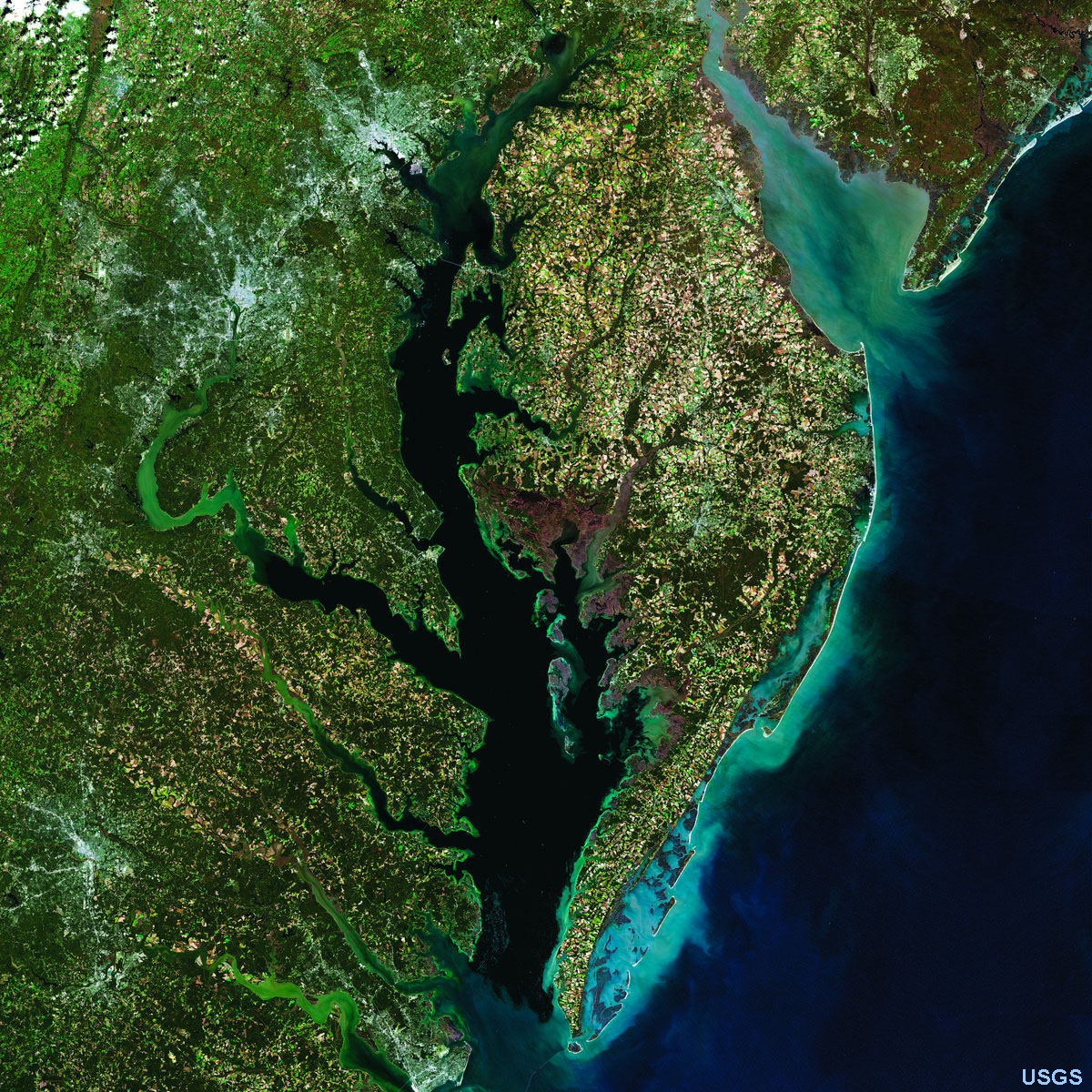
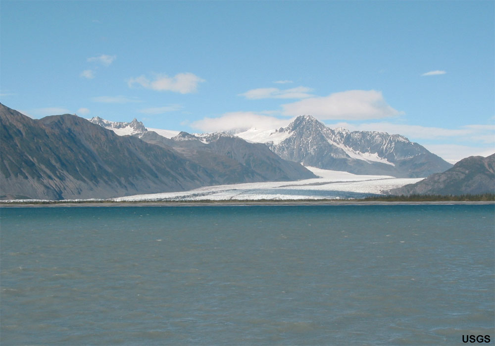
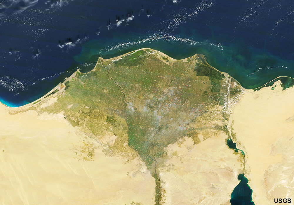
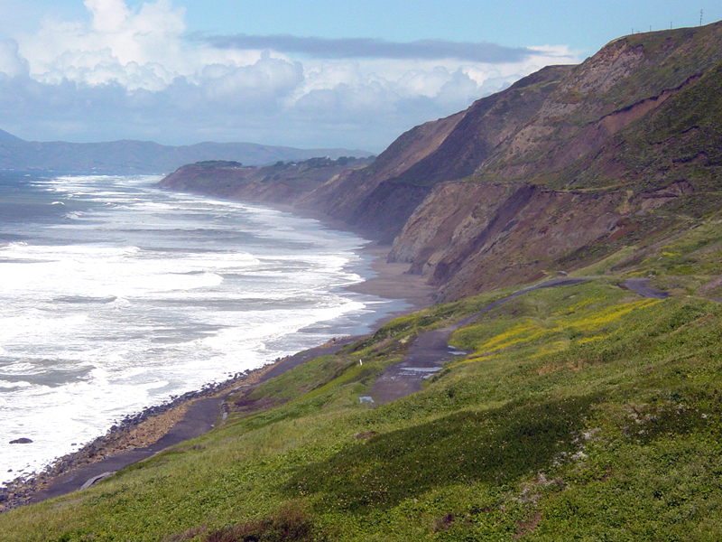
Primary Coasts - 5 TypesRia Coasts: Drowned river valleys caused by a rise in sea level.Examples: Chesapeake Bay (Figure 12-4). Glacial Coasts: Coastlines influenced by recent glacial activity such as glacial cut “U shaped” valleys called “fjords.” Examples: Norway, British Columbia, Alaska, Hudson Valley, New England region, Long Island (Figure 12-5). Deltaic Coasts: Coastlines associated with active river and delta systems. Examples: Mississippi and Nile Rivers (Figure 12-6). Volcanic Coasts: Coastlines associated with recent or active volcanoes (mostly basaltic or andesitic volcanoes). Examples: Hawaii, Aleutian Islands, Japan, Philippines, Indonesia (Figure 12-7). Fault/tectonic Coasts: Coastlines associated with major active fault systems along continental margins Example: San Andreas fault going off shore at San Francisco (Figure 12-8). |
|
|
||||||

Secondary CoastsSecondary coasts are coastlines that have been significantly changed by marine processes after sea level has stabilized allowing erosional and/or depositional processes to dominate shaping of the landscape. However, to explain this better, we need to examine the other classifications of coastlines first. |
||
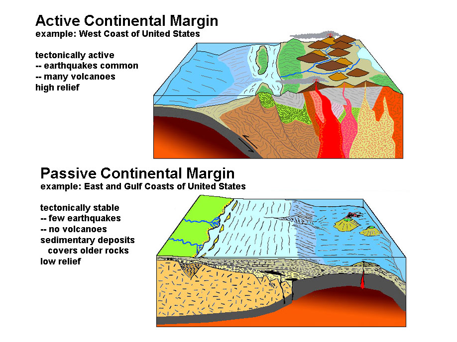
Both primary and secondary coasts are influenced by whether they are active or passive continental margins (the second method of coast classification). Both primary and secondary coasts are influenced by whether they are emergent or submergent coastlines (the third method of coast classification - discussed below). Passive margins tend to be submergent due to the ongoing rise in sea level (Figure 12-10). In contrast, active margins can be both emergent or submergent depending on local tectonic forces, such as caused by faulting. |
 |
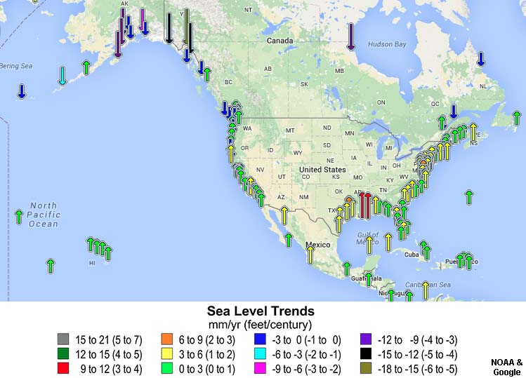 |
| Fig. 12-9. Active versus passive continental margins. | Fig. 12-10. Changing sea level trends around North America. | |
Coastlines on Active and. Passive Continental Margins In North America, the Pacific Coast is an active continental margin, whereas the Atlantic Coast is a passive continental margin (Figures 12-11 and 12-12). |
|
|
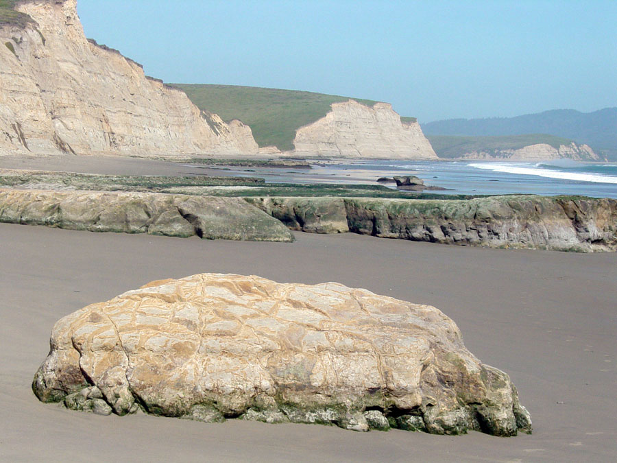
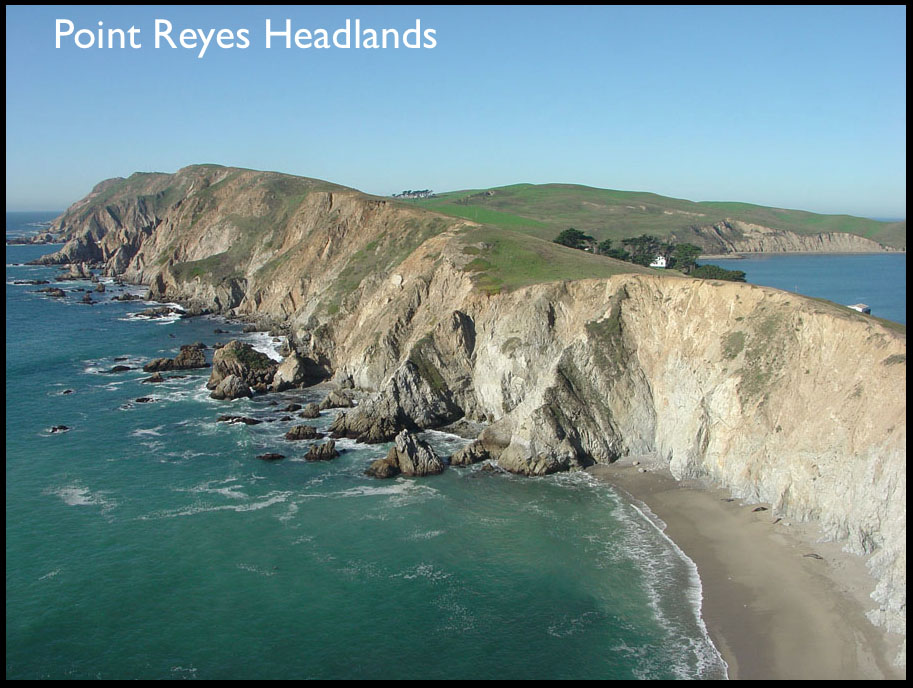
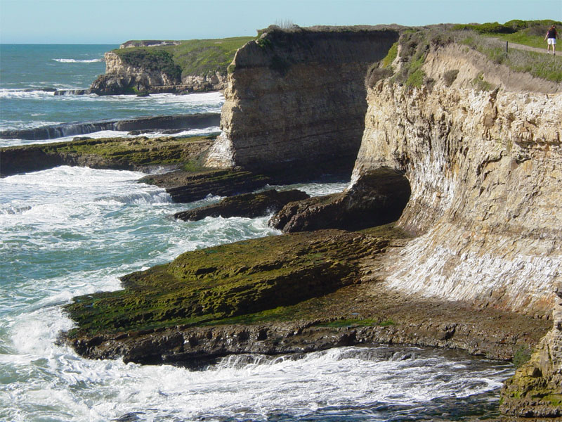
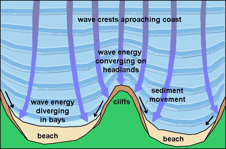
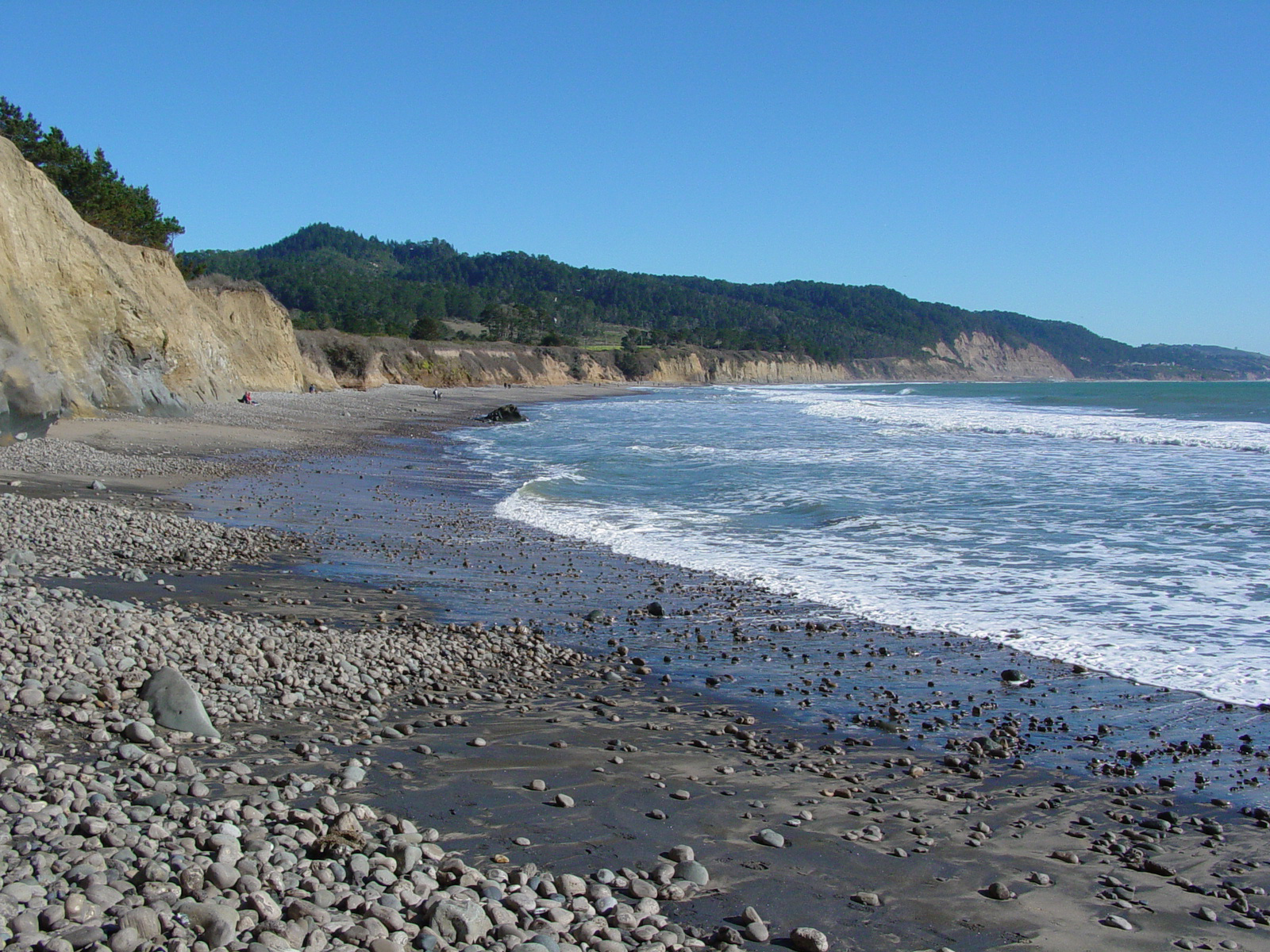
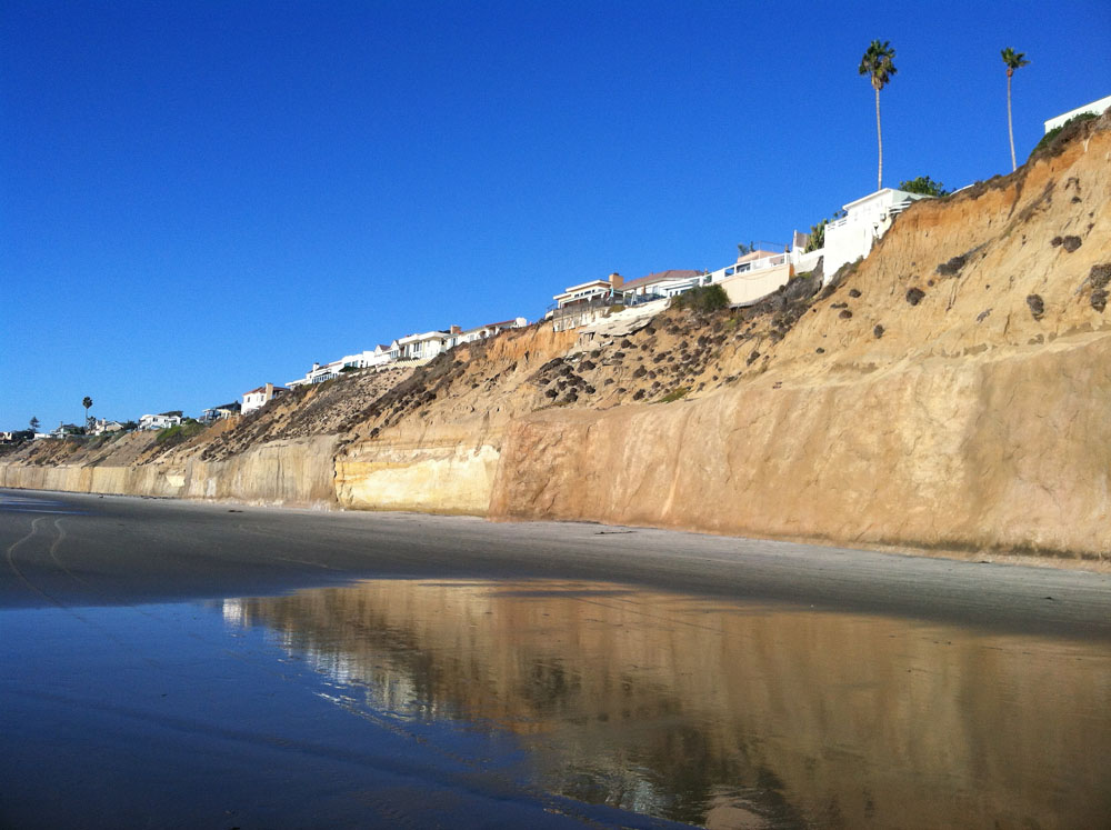
Erosional coastal landforms or featuresEmergent coastlines typically have sea cliffs carved by wave and current action along the shoreline, typically on secondary coastlines. The geometry of a coastline is largely a reflection of how some rocks along a coastline are more resistant to erosion.Sea Cliffs, Wave-Cut Platforms and Features* Sea cliffs form where persistent wave erosion carves into elevated coastlines.* Waves erode the base of cliff, causing it to subside or fail (Figure 12-13). * Waves carve a flat surface where they scour the seabed leading up to the beach creating a wave-cut platform. * When sea level locally falls falls (such as from uplift of a regional earthquake) wave action scours out a new wave-cut platform, leaving remnants of the old seabed surfaces exposed as expose wave-cut bench (Figure 12-14). A wave-cut bench is a flat bench-like platform of rock typically preserved in the upper surf zone associated with an actively eroding sea cliff on an emergent coastline (Figures 12-14 and 12-17, also see marine terraces below). Headlands are rocky shorelines that have resisted wave erosion more than surrounding areas, forming points or small peninsulas that jut seaward. Small sandy beaches typically occur in bays between headlands (Figure 12-15). Sea stacks are large rocky outcrops that have resisted wave erosion and stand offshore as the beach and sea cliff continues to erode landward * Mound of rock and debris that eventually is taken to sea by waves. * The product of a sea arch caving in (Figure 12-16). A sea cave is an underground passage or enclosed overhang carved into a sea cliff carved by focused wave action (Figure 12-17). A sea arch is a natural rock arch caved by wave action. Sea arches form where two caves join together or where a cave cuts through a narrow fin of rock (Figure 12-18). Marine terraces are elevated step-like benches formed by the combined effects of long-term wave erosion during the rise and fall of sea level on an emergent coastline (Figures 12-19 to 11-22). Marine terraces are old wave-cut platforms and benches that have been elevated by the land rising relative to the ocean surface. |
|
|
|
|
|
|
|
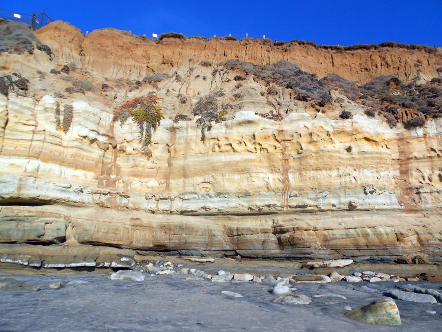


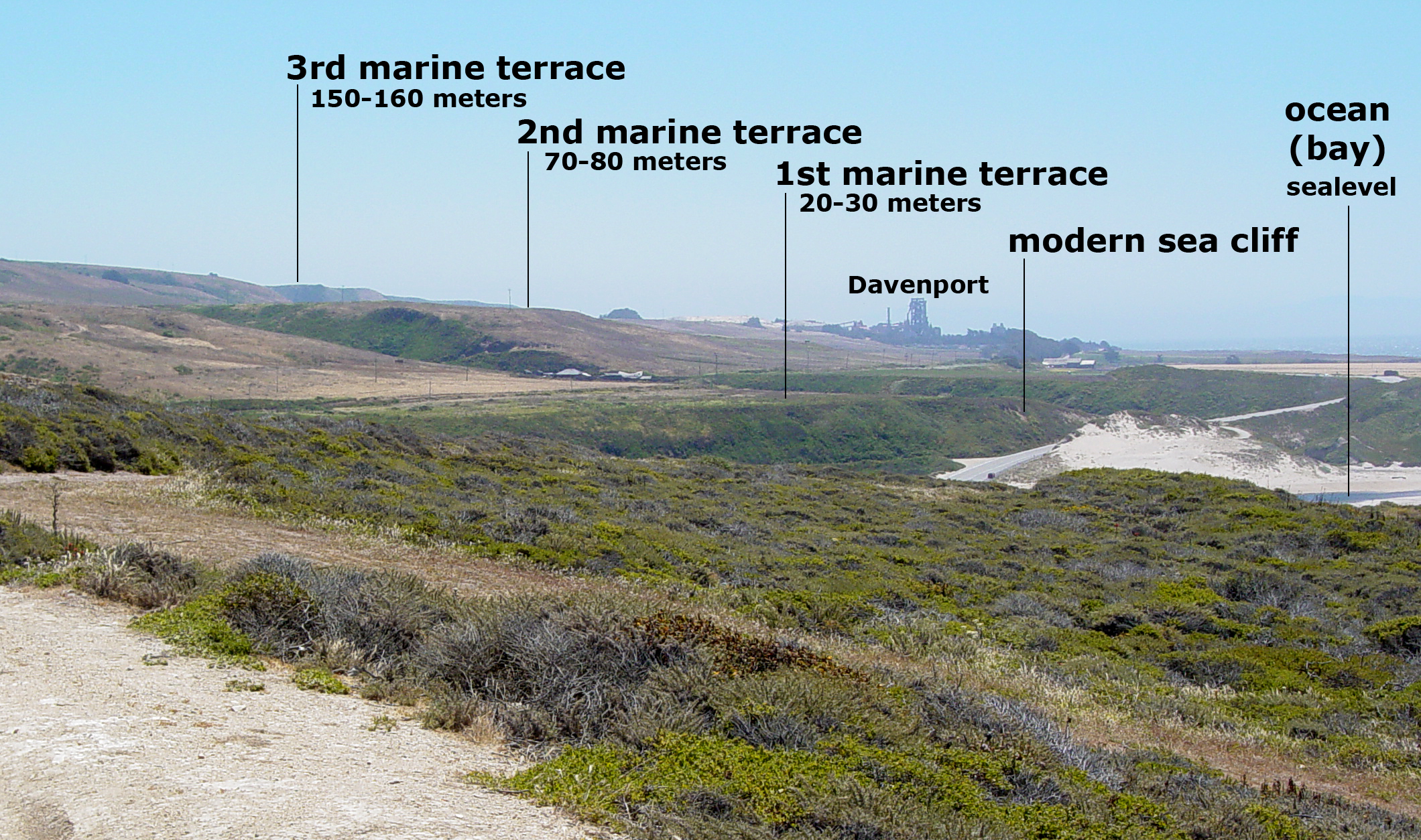
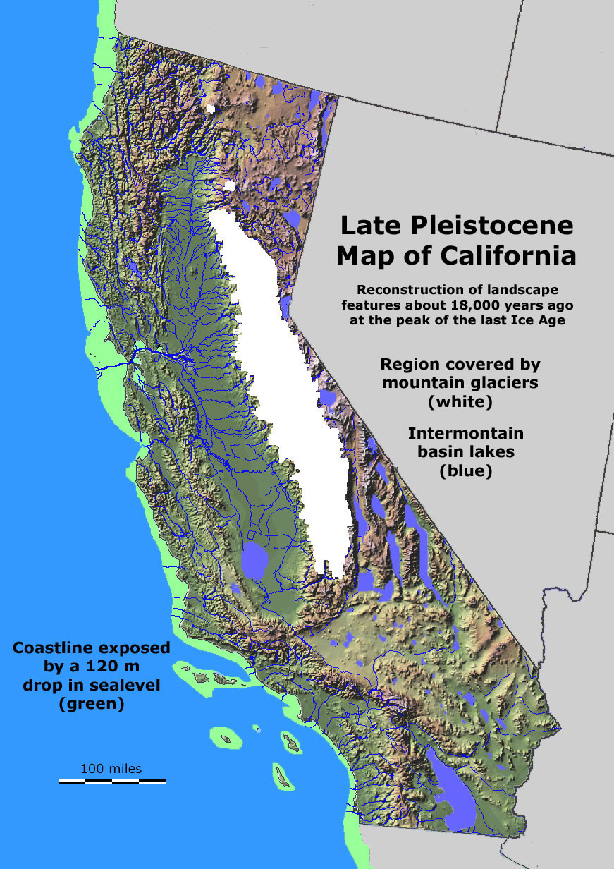
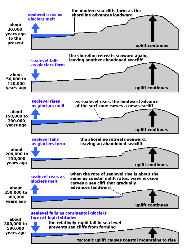
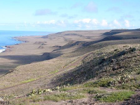
Elevated marine terracesElevated marine terraces occur in many locations along the California coastline, see Figures 12-19 and 12-20.California preserves much evidence of geologic, geographic, and climatic changes caused by ice ages. During the last ice age, alpine glaciers and ice caps covered upland regions in the Sierra Nevada Range and Cascades volcanoes, but lower elevations were ice free (Figure 12-21). The formation of continental glaciers in North America and Europe caused sea level to fall almost 400 feet, causing the shoreline to migrate seaward as much as 10 to 70 miles (16 to 110 km) westward of the current coastline in some locations. This rise and fall of sea level happened with each glaciation cycle (of which there were many through the ice ages of the Pleistocene Epoch). In places where the California coastline is slowly rising, each of the major glaciation cycles is preserved as a step-like bench, called a marine terrace. The formation of marine terraces is illustrated in Figure 12-22. |
|
|
|
|
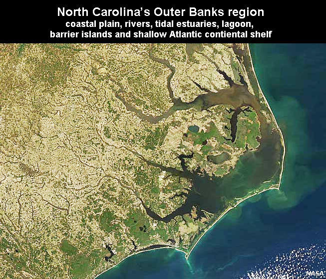
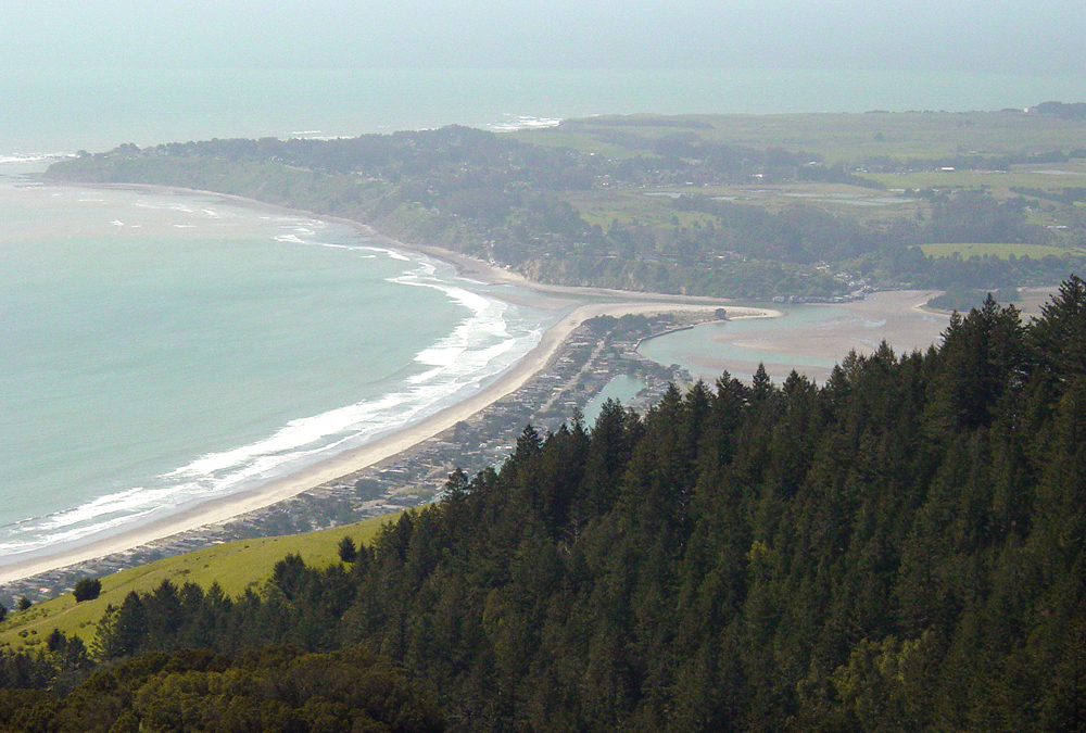
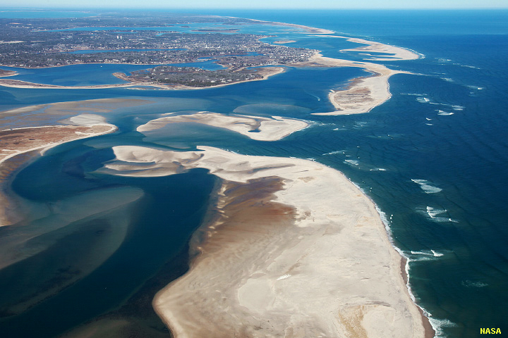
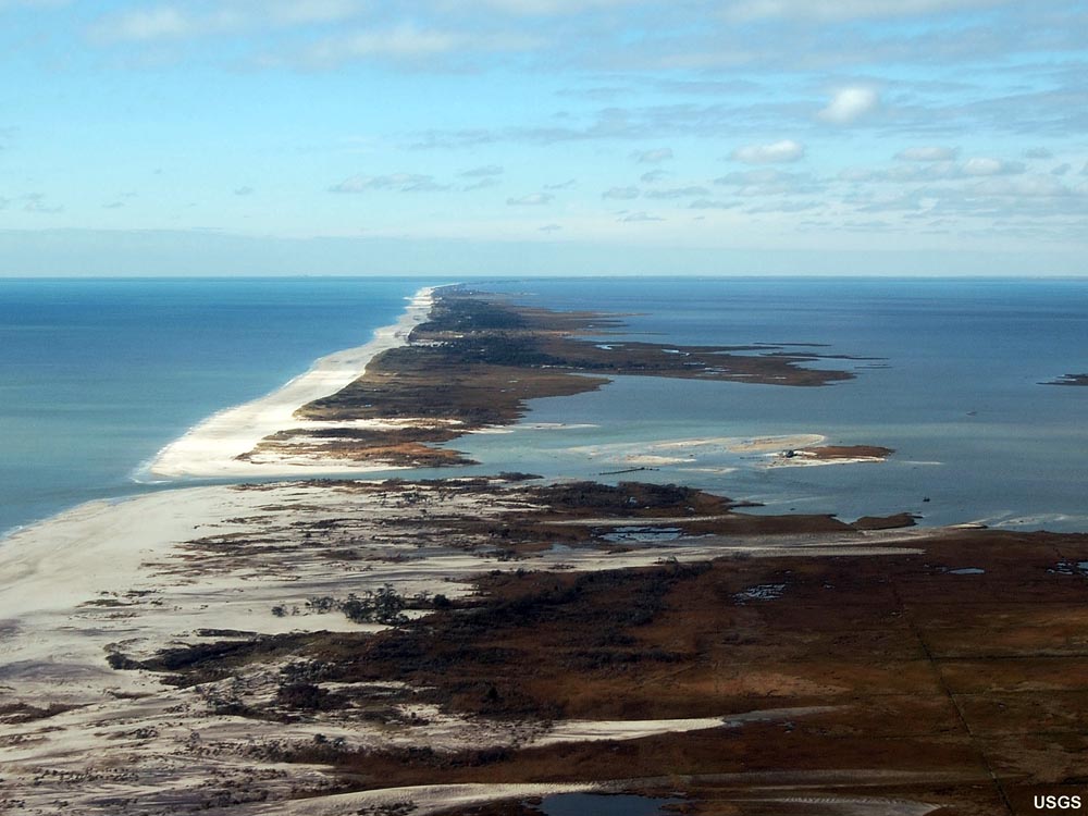
Depositional coastal landforms or features:A beach is the most obvious depositional landform along a coastline. Beaches may change, grow, shrink, or even disappear with changing seasons, tides, and storm cycles. They migrate landward or seaward as sea level is either gradually rising of falling (Figure 12-23). Beaches are typically sandy, but may also consist of gravel or shell material. Features associated with beaches include beach berms and dunes in the upper beach region. Beaches along lagoons and the entrances to rivers may be sand bars or may be muddy and be associated with tidal flats. Areas overgrown with plants in the intertidal zone are called a marsh.Spits are ridges of sand projected from land into the bay (Figure 12-24). Over time they may change grow down current for many miles, but are often cut by tidal inlets. A bay-mouth bar is a sandbar that stretches across a bay, separating it from the ocean (Figure 12-25). Barrier islands are ridges of sand islands that run parallel to the coast (Figure 12-26). Spits may be split into barrier islands. In locations where inlets occur cutting across bay-mouth bars or barrier islands, tidal deltas can accumulate sediments on both ends of an inlet. Ebb tidal deltas form as the outgoing tidal current erode and move and deposit sand on the seaward side of an inlet. Flood-tide deltas form where incoming tidal currents carry sediments eroded from the ocean-beach side of a barrier-island inlet and deposit them in the lagoon or bay side of an inlet. |
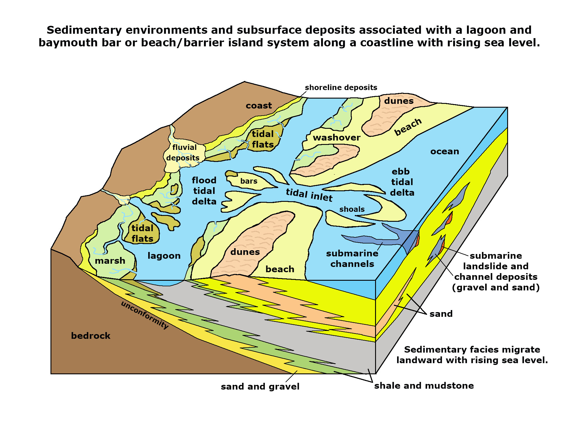 Fig. 12-23. Different kinds of coastal depositional environments illustrated and how they move with sea-level rise over time. |
 Fig. 12-24. Spits: Rockaway Spit (right, on Long Island, NY) and Sandy Hook Spit (New Jersey projects northward into outer New York Harbor and Raritan Bay). |
|
|
Emergent and Submergent Coasts Another important factor in understanding shorelines is tectonic activity and the rise and fall of sea level. |
|
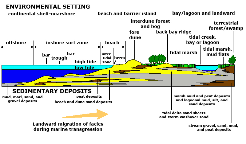
Common Shoreline Features of Beaches and Barrier Islands
Figure 12-28 illustrates common shoreline features and shoreline depositional environments associated with beaches, barrier islands, and lagoons. |
|
|
|
|


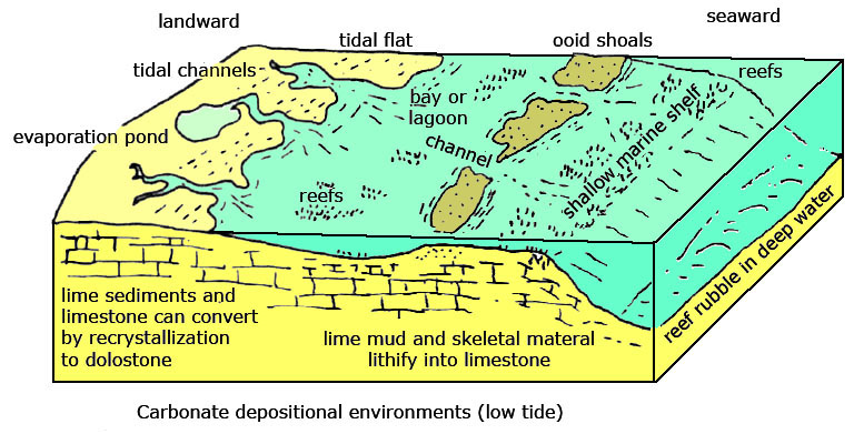
Coral Reefs, Keys, and AtollsBiogenous carbonate sediments can accumulate faster than sea level is rising. Skeletal reefs (including coral reefs) thrive in the surf zone, and are able to weather wave action, although they can be heavily damaged by superstorm wave energy. The sediments generated by wave erosion and bioerosion (critters eating critters) contribute to the buildup of carbonate islands (keys) and atolls associated with fringing reefs forming around extinct and eroding volcanic islands (Figures 12-32 to 11-34). Keys and reefs of the world experience exposure and erosion during low sea levels during the ice ages. |
|
|
|


Shoreline Erosion
Shoreline erosion depends on several factors: |
|
Seasonal Erosional Changes to a Beach Profile
During the winter, storm-wave energy is most intense. Waves wash up on the beach and erode sand, and transport it offshore to where wave-driven currents aren't so strong and the sand accumulates on offshore bars. Heavier materials (gravel and boulders) are concentrated on the beach (Figure 12-36). |
|
|
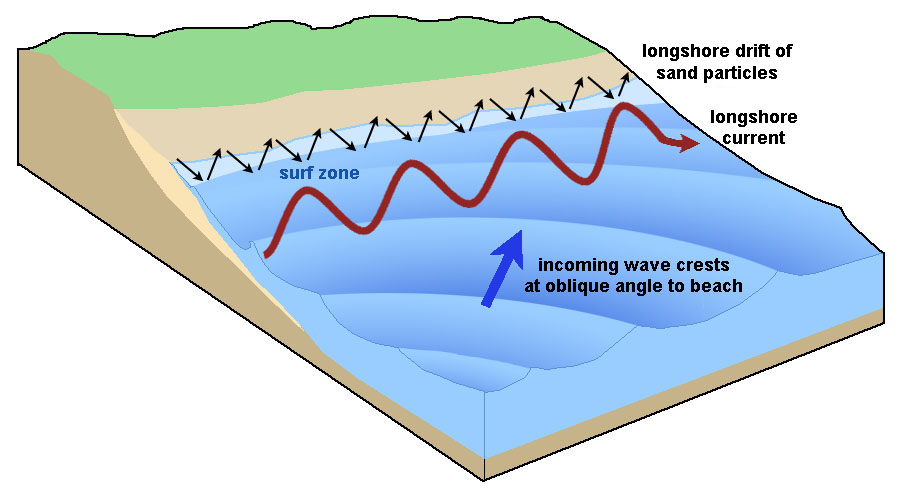
Longshore Currents and Longshore DriftA longshore current is a current that flows parallel to the shore within the zone of breaking waves. Longshore currents develop when waves approach a beach at an angle (Figure 12-38). Longshore currents cause sediment transport called longshore drift. Longshore drift is the movement of sediments along a coast by waves that approach at an angle to the shore but then the swash recedes directly away from it. The water in a longshore current flows up onto the beach, and then back into the ocean in a “sheet-like” formation. As this sheet of water moves on and off the beach, it can transport beach sediment back out to sea. Objects floating in the longshore current move in a zigzag pattern up and down the beach as it moves down current. |
|
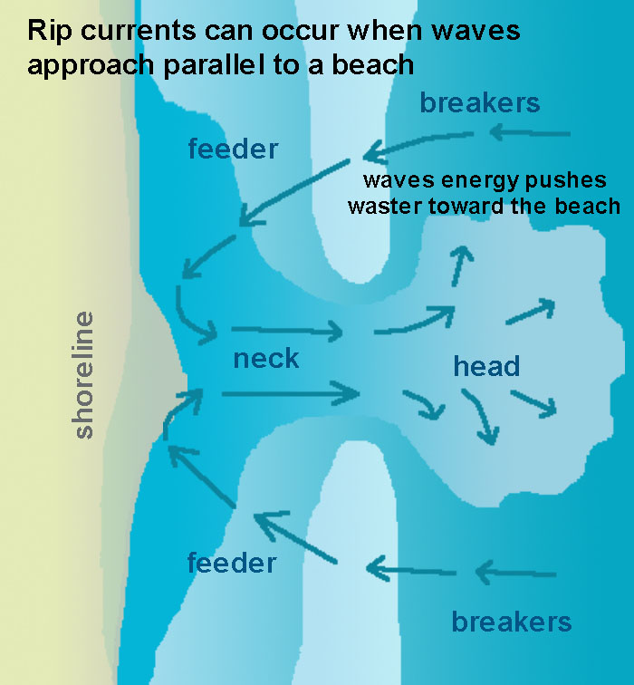
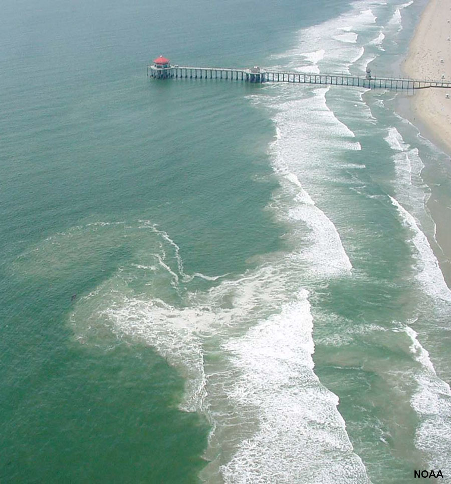
Rip Currents and Rip Tides
A rip current (or just “rip”) is a current that flows away from the coast (Figures 12-39 and 12-40). Rip currents form when wave break strongly in one direction, but weakly in another. In the surf zone, breaking waves produce currents that flow both along the shore and out to sea. Rip currents typical form on beaches with a sand bar and channel system in the nearshore area. A rip current forms as a narrow fast-moving current of water moving in an offshore direction. Obstructions in the water can also deflect current offshore. Rip current vary in size and speed (up to 6 miles per hour [10 km/hr], or faster than an Olympic swimmer). Rip currents move offshore and dissipate beyond the breaker zone. If caught in a rip current, swim parallel to shore to leave the current before heading for shore. |
|
|
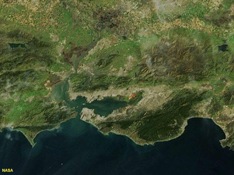
Tidal currents (including rip tides) are strong erosional forces where they are restricted at the mouths of inlets and straights between bodies of water. One example include the narrow straights of the Verrazano Narrows (between Staten Island and Brooklyn on Long Island, NY) (Figures 12-41 and 12-42). Another example is the Golden Gate Narrows between San Francisco and Marin County in northern California (Figure 12-43). In both cases, the seabed has been scoured deeply by the daily tidal flows. Tidal flows redistribute sediments building submerged tidal deltas at opposite ends of the channel that need to be dredged frequently to mitigate hazards to shipping. |
 Fig. 12-41. Dominant winds, waves, and currents of the New York City region. |
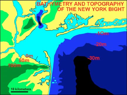 Fig. 12-42. Bathymetry shows tidal current scour in the Verrazano Narrows. |
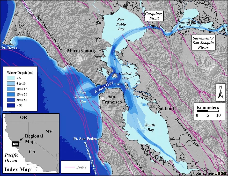 Fig. 12-43. Bathymetry shows tidal current scour in near the Golden Gate Bridge. |
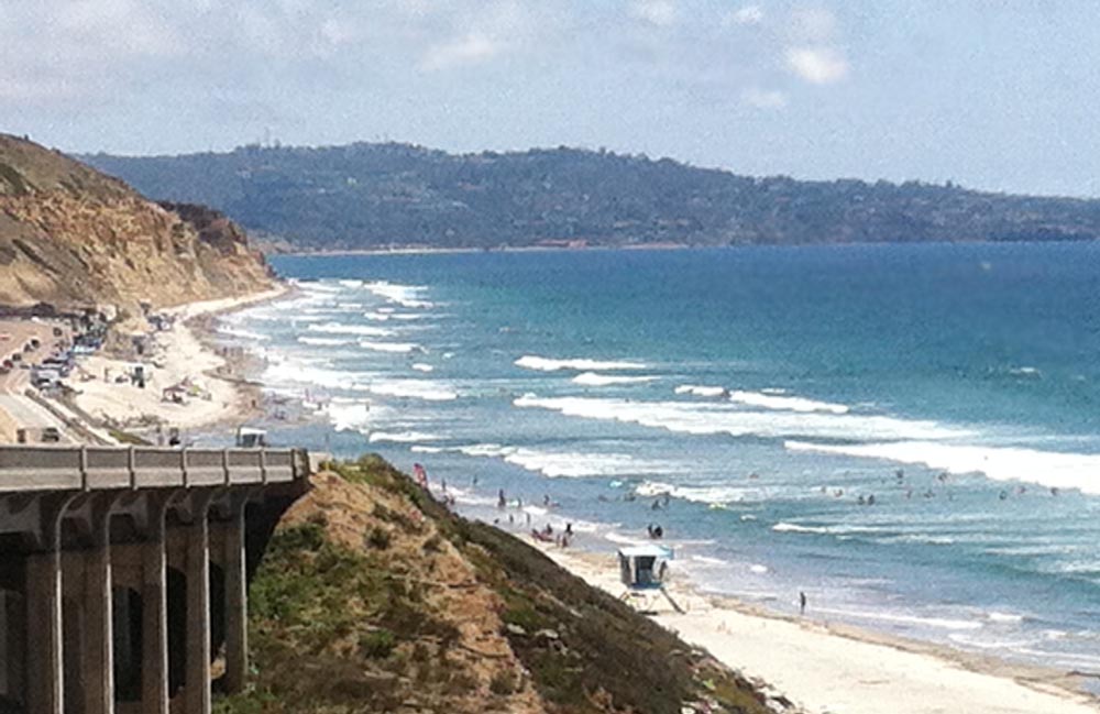
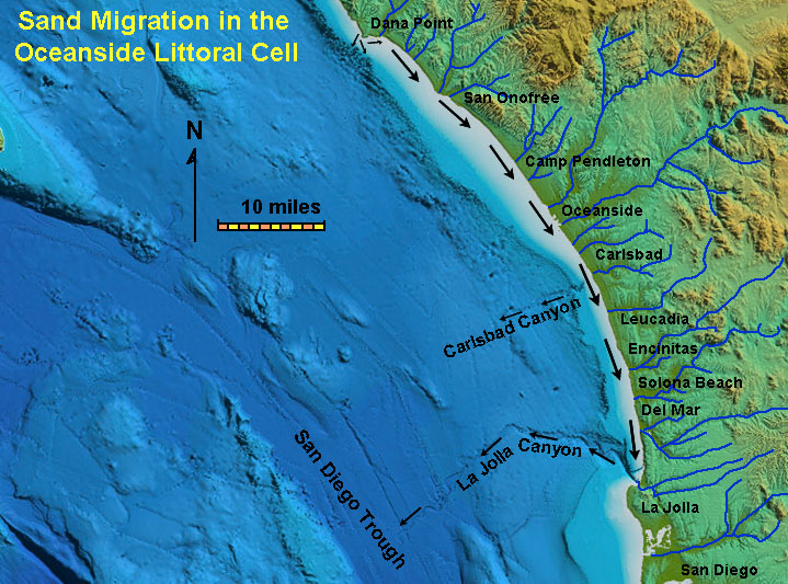
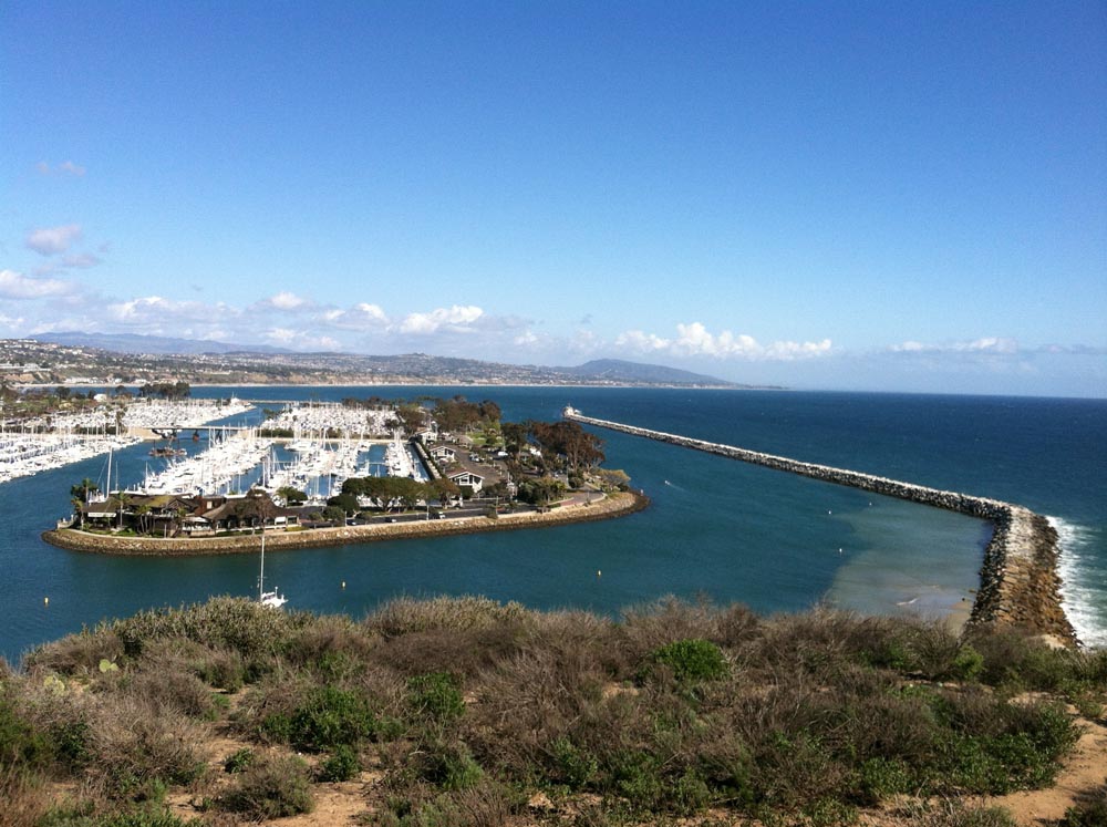
Coastal Littoral CellsA coastal cell is a relatively self-contained compartment within which sediments circulate. A coastal cell contains a complete cycle of sedimentation including sources, transport paths, and sinks. In the San Diego area, the Oceanside Coastal Cell extends from Dana Point to La Jolla Canyon; some of the sand is lost to Carlsbad Canyon as well (Figure 12-44). Streams and cliff erosion provide sediments to the shore zone. The arrow on the map indicates the predominant longshore current direction (and the direction of the migration of beach sand along the coast). Most of the sand moves down the coast and eventually drains down La Jolla Canyon and is deposited as turbidity flow deposits on the La Jolla Canyon deep-sea fan in the San Diego Trough (Figure 12-45). |
|
 Fig. 12-45. Sediments move from shore down La Jolla Canyon to the San Diego Trough at the southern end of the Oceanside littoral cell. |
San Diego's Coastal Erosion Problems Related To the Oceanside Coast CellThe
dominant swell direction in northern San Diego County is from the northwest. This creates longshore currents that move sediments (longshore drift) from north to south along area beaches. The sand on northern San Diego County beaches are mostly derived from sediments derived from coastal erosion in the shallow nearshore, beach, and sea cliffs along the coast between Dana Point and Oceanside (much of it from along the undeveloped coast within Camp Pendleton north of Oceanside). In addition, large quantities of sandy sediments are contributed to beaches from streams (small rivers) that, during episodic floods, dump large amounts of fresh sediment into the nearshore environment, contributing about half of the sand supply to area beaches over time. The amount of sand from river sources is highly variable with the seasonal weather, year to year. |
Shoreline Erosion ProblemsShoreline changes quickly with natural forces; they are not a stable landforms. Coastlines, especially on the East Coast and Gulf regions, are constantly changing, especially from the impacts of superstorms. These coastal regions are underlain by unconsolidated sediments
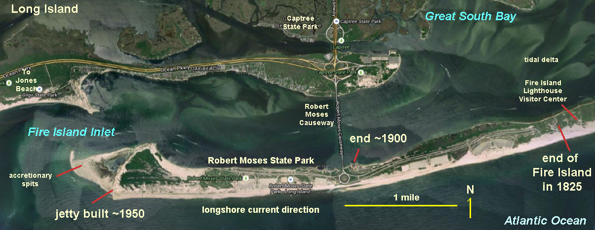
that are easily eroded by strong currents. They remain relatively stable, as long as there is a new supply of sediment to replace materials eroded by longshore currents, tides, and storm waves. Figure 12-46 illustrates how much shorelines can change. In less than two centuries, Fire Island's eastern spit has grown about 5 miles (8 km) longer. The sediments creating this new land came at the expense of coastal lands father east on Fire Island, making the island increasing narrower. Barrier Islands are prone to be breached by storm erosion, creating new inlets, and filling in others. |
|
Jetties and Groins
Jetties are built at entrances to rivers and harbors. Their purpose is to protect properties from storm and wave damage, and to keep sand out of channels (so that there is no beach). Jetties require high maintenance costs to manage because they impede longshore drift (which is continues relentlessly). Most the costs are for dredging sand from one side, and moving it down current to replenish sand to community beaches. Loss of the sand supply makes down current areas susceptible to beach loss and coastal erosion (a major problem for Southern California's coastal communities, Figures 12-47 and 12-48). |
|
|

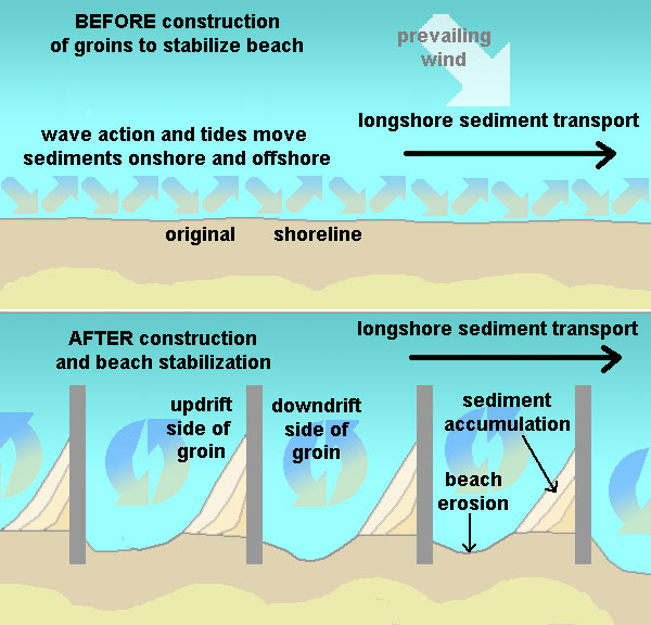
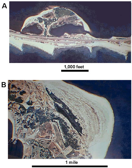
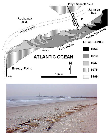
Groins are built as barriers perpendicular to the beach in an attempt to stabilize shorelines. Their purpose is to trap sand migrating along the shore by longshore drift (Figure 12-49). Figure 12-50A is an aerial view of a wash-over fan created by a breach in Sandy Hook Spit (on the New Jersey side of New York City's Outer Harbor (see Figure 12-24).The inlet formed when coastal storm waves and currents cut an inlet across the spit. Note the sand trapped on the left side of the groins (longshore drift is moving left to right). Figure 12-50B shows an accretionary prism of sand building up at the end of Sandy Hook Spit. Figure 12-51 shows the growth of Rockaway Spit on the north east side of New York's Outer Harbor. It has grown nearly 2 miles (3 km) since the end of the Civil War (1866). The area has been heavily modified by construction of groins and a jetty to keep the inlet to Jamaica Bay accessible to boat navigation. |
|
|
|
Other structures used to protect properties from the destruction by the sea
* Breakwaters are structures used to protect boats from large waves (jetties and groins are forms of breakwaters). |
|
|
The Dam ProblemDams have been constructed on most of the small rivers and streams throughout upland regions of San Diego County. The intentions of dam construction were to store water (reservoirs) and to reduce flood damage in low-lying communities. The problem is that dams have largely shut off the supply of sand from rivers and streams to the shore. One of the largest dams is for Lake Hodges on the San Dieguito River near Escondido, California (Figure 12-54). Construction of highway and railroad bridges, dikes, and causeways also restrict the flow of sediment-bearing water, preventing the migration of sediment to the coast. As a result, less sand is finding its way to the shore, resulting in narrower beaches. Without the protection of well-developed beaches, erosion of the sea cliffs are progressively endangering homes and infrastructure along the coast. |
|

Dam construction: The easy way to kill a coastal community.Dams on rivers trap sediments that would otherwise find their way to ocean beaches. A classic example was the construction of a dam on Matilija Creek in Ventura County. The dam is currently being demolished in order to return the sediment flow to sensitive habitats along the river downstream, but also to return a sediment supply to the Ventura County coastline (Figure 12-54). Many other dams constructed in the 19th and 20th century are being removed for the same reasons. |
|
Coastal Dynamics—The Unending SagaSea-level rise due to global warming is a highly political topic of our times. The world's Scientific Community has been studying the changes happening around the world for many decades. Real-time observations show that the atmospheric temperatures are steadily rising along with the concentrations of greenhouse gases in the atmosphere. What is perhaps most alarming is that the rate of sea-level rise is accelerating as the ice caps melt and the oceans expand from increased warmth (there are many NASA and NOAA websites on these matters). However, the threat doesn't seem to fit within the interest span of politicians and corporations keen on making high profits from the extraction of coal, oil, and gas. Sea-level rise will likely continue unabated until either we either consume all the economically available carbon-based resources, or human populations collaborate to change the fate we, collectively, are facing. |

Impacts of Climate Change on Coastal EnvironmentsClimate change is causing a wide variety of impacts on coastal environments including physical changes to the landscape and shallow nearshore settings, biological impacts, and societal impacts. The breadth and scope of climate change is too much to be presented here.In fact, many colleges with STEM programs are now offering courses and degrees specifically dedicated to the study of climate change. See https://climate.gov/ for a sample of information presented by NOAA. Below is a guide to some of those observable impacts, as well as how they will likely project into the future if little or nothing is done to mitigate the problems associated with human-induced climate change. Although natural fluctuations occur in the world climate, as illustrated natural cycles associated with ebb and flow or the Ice Ages, what humans have done to change the environment in the last 100 years is significant, and is of grave concern for the future of our planet. The baseline problem is the contribution of greenhouse gases to the atmosphere through consumption of fossil fuels, deforestation, agricultural activities, urban growth, and more. Below is a list of some of the known impacts of climate change on coastal environments.
In short, climate change is now arguably the #1 concern of the world's scientific community. |
| Chapter 12 quiz questions |