1. The region on the East Coast (including the Delmarva Peninsula, Chesapeake Bay, and Delaware Bay) is what kind of Coast?
a. Ria coast
b. Deltaic coast
c. Glacial coast
d. Fault/tectonic coast
2. Exposed wave-cut cliffs and platforms, and marine terraces are most frequently found along:
a. submergent (sinking) coasts.
b. static coasts (stationary) coasts.
c. emergent (rising) coasts.
d. all of the above.
3. Large rocky outcrops that have resisted wave erosion and remain as small isolated islands offshore as the beach and sea cliff continues to erode landward are called:
a. headlands.
b. wave-cut benches.
c. sea stacks.
d. sea arches.
4. Over time, sea level has risen and fallen many times in the past during the ice ages. Along emergent coastlines, such as along many parts of California's coastline, the interactions of these gradual sea level changes and a slowly rising coastline has resulted in the formation of:
a. elevated marine terraces.
b. spits.
c. bay mouth bars.
d. barrier islands.
5. Low ridges of sand that parallel coastlines and rise above sea level are called:
a. barrier islands.
b. marine terraces.
c. wave-cut platforms.
d. tidal deltas.
6. Which of the following is NOT a depositional coastal landform?
a. spit
b. baymouth bar
c. beach
d. sea cliff
7. A depositional coastal feature that form where incoming tidal currents carry sediments eroded from the ocean-beach side of a barrier-island inlet and deposit them in the lagoon or bay side of an inlet is called:
a. a spit.
b. a bay-mouth bar.
c. an eb tide delta.
d. a flood-tide delta.
8. Barrier islands are most common in regions where there are:
a. emergent active continental margins.
b. submergent passive continental margins.
c. volcanic island chains along coastlines.
d. subduction zones along coastlines.
9. Barrier island beaches generally develop where:
a. the coast is composed of hard rock.
b. the nearby land has a rugged topography of hills and mountains.
c. the sea floor deepens rapidly offshore.
d. the sea floor remains shallow for a long distance offshore.
10. When incoming waves reach an irregular coastline, how is their energy distributed?
a. It is equally distributed between bays and headlands.
b. It is focused on bays and cuts them deeper.
c. It is focused on headlands and erodes them back.
d. It is reflected back out to sea.
11. During stormy periods in winter, what happens to beaches?
a. There is a higher percentage of fine-grained sand on beaches.
b. More erosion occurs in bays than on headlands.
c. Beaches are eroded and the sand moves to offshore bars.
d. Offshore sand bars are eroded and beaches are built up.
12. How are longshore currents and longshore drift best described?
a. They involve movement of water and sediment perpendicular to the shoreline.
b. They involve movement of water and sediment toward the shoreline.
c. They involve movement of water and sediment parallel to the shoreline.
d. They involve movement of water and sediment away from the shoreline.
13. What is significant about longshore currents?
a. They are agents of erosion along shorelines.
b. They are agents of deposition along shorelines.
c. They move in directions dependent on the direction of the dominant incoming swell.
d. All of the above.
14. A strong current associated with the swift movement of water through inlets and the mouths of estuaries, embayments, and harbors is called a:
a. longshore drift.
b. longshore current.
c. rip current.
d. rip tide.
15. Construction of dams upstream on rivers may lead to which of the following?
a. Narrower beaches
b. Wider beaches
c. The filling in of bays with sediment
d. The building of a barrier island
16. An artificial barrier built at a right angle to the beach to trap sand that is moving parallel to the shore is known as a:
a. groin.
b. stack.
c. seawall.
d. breakwater.
17. On which side of a groin would sand collect if it was put into a south-flowing longshore current?
a. on the north side.
b.on the south side.
c. on both the north and south sides.
d. on neither side.

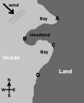
Examine the diagram above showing an irregular coastline (common on many portions of the California Coast).
The arrow shows the wind direction; lines show incoming swell. Use the diagram to answer questions 18 and 19 below.
18. Longshore currents are likely to travel along the coast from:
a. mostly north to south.
b. mostly south to north.
c. mostly east to west.
d. mostly in a northeast direction.
19. Examine the diagram above. Which part of the coast would likely receive the maximum amount of wave energy?
a. Location A
b. Location B
c. Location C
d. Location D
20. Which of the following choices is a significant cause of coastal erosion, requiring expensive efforts to restore beaches along coastal California?
a. Dams trap sandy sediments that would otherwise be carried by floodwaters to be deposited on coastline beaches.
b. Lack of a supply of sand to a beach allows wave energy to erode sea cliffs, endangering coastal homes and infrastructure.
c. Construction of jetties to protect harbors end up trapping sediments that would otherwise migrate along the coast by longshore drift.
d. all of the above.
|

