Tonto Group
Tonto Group*
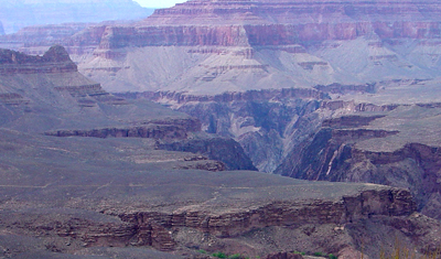
View of the Tonto Group on the Tonto Platform (above the Inner Gorge) as seen from Grand Canyon's South Kaibab Trail.
Cambrian, Early*
Cambrian, Middle*
Early to Middle Cambrian - 525-505 million years (age used by National Park Service;
Mathis and Bowman, 2005)
Plateau sedimentary province*
AZ(n)*
Not compiled to date. Tonto Group floors the valleys that contain the headwaters of the Colorado and of the Verde and Tonto Creek, tributaries of the Salt River [Coconino and Mohave Cos], AZ (Gilbert, 1875)
Subunits:
Tapeats Sandstone, Bright Angel Shale, and Muav Limestone
First used (Gilbert, 1875). Revised (Walcott, 1883). Divided into Tapeats Sandstone, Bright Angel Shale, and Muav Limestone (Noble, 1914). Members of Bright Angel Shale and Muav Limestone named; upper contact revised (McKee, 1945). Not used (Hereford, 1975). Revised (Billingsley and others, 1989).
Tonto Group (Middle and Lower Cambrian)—Includes, in descending order, Muav Limestone, Bright Angel Shale, and Tapeats Sandstone as defined by Noble (1922) and modified by McKee and Resser (1945). These Cambrian units are recognized on the basis of distinct rock types: limestone and dolomite lithologies belong to the Muav; shale and siltstone lithologies belong to the Bright Angel; and sandstone and conglomerate lithologies belong to the Tapeats. Tonto Group overlies tilted strata of Grand Canyon Supergroup of Middle to Late Proterozoic (1.4–1.1 billion years) age in eastern and central parts of map area, and igneous and metamorphic rocks of Early Proterozoic (1.7–1.6 billion years) age in western part of map area. This hiatus is known regionally as the Great Unconformity.
Muav Limestone (Middle Cambrian)—Dark-gray, light-gray, brown, and orangered, cliff-forming limestone, dolomite, and calcareous mudstone. Includes, in descending order, unclassified dolomites, and Havasu, Gateway Canyon, Kanab Canyon, Peach Springs, Spencer Canyon, and Rampart Cave Members of McKee and Resser (1945). These members consist of fine- to medium-grained, thin to thick-bedded, mottled, fossiliferous, silty limestone, limestone, and dolomite. Three unnamed slope-forming siltstone and shale units of Bright Angel Shale lithology are intertongued between cliff-forming members of Muav Limestone. These unnamed siltstone and shale units are green and purplish-red, micaceous siltstone, mudstone, and shale, and thin brown sandstone. Contact with the underlying Bright Angel is gradational and lithology dependent. Contact is arbitrarily marked at base of lowest prominent cliff-forming limestone of Rampart Cave Member of the Muav in western half of map area, and of Peach Springs–Kanab Canyon Members of the Muav in eastern half of map area. All members of the Muav thicken from east to west across map area. However, the Peach Springs, Spencer Canyon, and Rampart Cave change to purple-red and green siltstone/shale facies of the Bright Angel in eastern half of map area, where they are included as part of the Bright Angel . Intertonguing and facies change relationships between the Muav and Bright Angel produce variable thickness trends. Overall, the Muav thickens from about 350 ft (107 m) in eastern part of map area to about 600 ft (183 m) in western part.
Bright Angel Shale (Middle Cambrian)—Green and purple-red, slope-forming siltstone and shale, and interbeds of red-brown to brown sandstone of Tapeats Sandstone lithology. Includes ledge-forming red-brown sandstone member of McKee and Resser (1945). Consists of green and purple-red, fine-grained, micaceous, ripple-laminated, fossiliferous siltstone and shale; dark-green, medium- to coarse-grained, thin-bedded, glauconitic sandstone; and interbedded purplish-red and brown, thin-bedded, fine- to coarse-grained, ripple-laminated sandstone. Includes gray, thin-bedded, fine-grained, micaceous silty dolomite in upper part of unit in western quarter of map area. Intertonguing and facies change relationships with the underlying Tapeats produce variable thickness trends. Contact with the Tapeats is arbitrarily marked at lithologic vertical and lateral transition from predominantly green siltstone and shale to predominantly brown sandstone in slope above the Tapeats cliff. Thickness is about 350 ft (107 m) in eastern quarter of map area, thickening to about 500 ft (150 m) in western quarter.
Tapeats Sandstone (Middle and Lower Cambrian)—Brown and red-brown, cliff-forming sandstone and conglomerate. Includes an upper slope-forming transition zone of nearly equal distribution of brown sandstone of Tapeats Sandstone lithology and green siltstone and shale of Bright Angel Shale lithology, and a lower unit of cliff-forming sandstone and conglomeratic sandstone. Lower cliff unit consists mainly of medium- to coarse-grained, thin-bedded, low-angle planar and trough cross-bedded sandstone and conglomeratic sandstone; sandstone beds 6–24 in. (15–60 cm) thick. Unconformable contact with underlying Middle and Late Proterozoic surface that forms the Great Unconformity. The Tapeats fills in lowland areas and thins across or pinches out against young Proterozoic highlands. Variable thickness 0–400 ft (0–122 m).
References
Gilbert, G.K., 1875, Report upon the geology of portions of Nevada, Utah, California, and Arizona, Chapter 6, IN Report on the geographical and geological explorations and surveys west of the One hundredth meridian (Wheeler): U.S. Geological and Geographical Survey, Publication of the Wheeler Survey, v. 3, p. 17-187.
Walcott, C.D., 1883, Pre-Carboniferous strata in the Grand [Canyon] of the Colorado, Arizona: American Journal of Science, 3rd series, v. 26, p. 437-442.
Noble, L.F., 1914, The Shinumo quadrangle, Grand Canyon district, Arizona:
U.S. Geological Survey Bulletin, 549, 100 p., (incl. geologic map, scale
1:48,000).
Noble, L.F., 1922, A section of the Paleozoic formations of the Grand Canyon at the Bass Trail: U.S. Geological Survey Professional Paper 131-B, p. 23-73.
McKee, E.D., 1945, Stratigraphy and ecology of the Grand Canyon Cambrian,
Part 1; IN
McKee, E.D., and Resser, C.E., Cambrian history of the Grand Canyon region: Carnegie Institution
of Washington Publication, no. 563, p. 1-170.
McKee, E.D., and Resser, C.E., 1945, Cambrian history of the Grand Canyon region: Carnegie Institution of Washington Publication 563, 232 p.
Hereford, Richard, 1975, Chino Valley Formation (Cambrian?) in northwestern Arizona: Geological Society of America Bulletin, v. 86, no. 5, p. 677-682.
Billingsley, G.H., Elston, D.P. and Kieffer, S.W., 1989, Geologic log of Colorado River from Lees Ferry to Temple Bar, Lake Mead, Arizona, Part II, IN Elston, D.P., Billingsley, G.H., and Young, R.A., editors, Geology of Grand Canyon, northern Arizona (with Colorado river guides); Lees Ferry to Pierce Ferry, Arizona; guidebook to field trips T115 and T315: International Geological Congress, 28th, Field Trip Guidebook, T115, T315, Washington, DC, 1989, p. 1-36.
Middleton, L.T., Elliot, D.K., 1990, Tonto Group. In: Beus, S.S., Morales, M., editors, Grand Canyon Geology, Oxford University Press, New York, p. 83-106.
Rose, Eben, 2000, Allostratigraphy, sequence stratigraphy, and paleoenvironmental
reconstruction of the Cambrian Tonto Group, Grand Canyon, Arizona: Geological
Society of America, Abstracts with Programs, v. 32, no. 7, p. 265.
Billingsley, George H., 2000, Geologic Map of the Grand Canyon 30' by 60' Quadrangle, Coconino and Mohave Counties, Northwestern Arizona: U.S. Geological Survey Geologic Investigation Series I-2688, Available on-line at: http://pubs.usgs.gov/imap/i-2688/.).
Mathis, A. and Bowman, C., 2005, What's in a number? Numeric ages for rocks exposed within the Grand Canyon, Part 2: Nature Notes ( Grand Canyon National Park ), v. 21, no. 2, p. 1-5.