Tapeats Sandstone
Tapeats Sandstone of Tonto Group (AZ*)
Tapeats Sandstone (NV*,UT*)
Tapeats Quartzite (CA*)
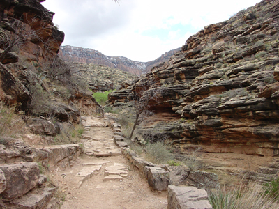
Tapeats Sandstone outcrops along Grand Canyon's Bright Angel Trail.
Cambrian, Early*
Cambrian, Middle* (local)
Middle Cambrian - 525 million years
(age used by National Park Service;
Mathis and Bowman, 2005)
Plateau sedimentary province*
Basin and Range province*
Salton basin*
Great Basin province*
Mojave basin*
AZ(n)*
CA(se)*
NV(s)*
UT(sc)*
Not designated. Named for Tapeats Creek, Kaibab quad, Coconino Co., AZ. Typical section measured and described in Shinumo quad (Noble, 1914).
Named as basal formation of Tonto Group (Noble, 1914). Overview (McKee, 1945). Revised (Ford and Breed, 1973). Areal limits (Peterson and Barnum, 1973). Areal limits; Revised (Hereford, 1975). Overview (Hereford, 1977). Redescribed (Hamilton, 1982).
Tapeats Sandstone (Middle and Lower Cambrian)—Brown and red-brown, cliff-forming sandstone and conglomerate. Includes an upper slope-forming transition zone of nearly equal distribution of brown sandstone of Tapeats Sandstone lithology and green siltstone and shale of Bright Angel Shale lithology, and a lower unit of cliff-forming sandstone and conglomeratic sandstone. Lower cliff unit consists mainly of medium- to coarse-grained, thin-bedded, low-angle planar and trough cross-bedded sandstone and conglomeratic sandstone; sandstone beds 6–24 in. (15–60 cm) thick. Unconformable contact with underlying Middle and Late Proterozoic surface that forms the Great Unconformity. The Tapeats fills in lowland areas and thins across or pinches out against young Proterozoic highlands. Variable thickness 0–400 ft (0–122 m)
Noble, L.F., 1914, The Shinumo quadrangle, Grand Canyon district, Arizona: U.S. Geological Survey Bulletin, 549, 100 p., (incl. geologic map, scale 1:48,000).
McKee, E.D., 1945, Stratigraphy and ecology of the Grand Canyon Cambrian, Part 1; Cambrian history of the Grand Canyon region: Carnegie Institution of Washington Publication, no. 563, p. 1-170.
Ford, T.D. and Breed, W.J., 1973, Late Precambrian Chuar Group, Grand Canyon, Arizona: Geological Society of America Bulletin, v. 84, no. 4, p. 1243-1260.
Peterson, Fred and Barnum, B.E., 1973, Geologic map and coal resources of the northeast quarter of the Cummings Mesa quadrangle, Kane County, Utah: U.S. Geological Survey Coal Investigations Map, C-63, 2 sheets, scale 1:24,000.
Hereford, Richard, 1975, Chino Valley Formation (Cambrian?) in northwestern Arizona: Geological Society of America Bulletin, v. 86, no. 5, p. 677-682.
Hereford, Richard, 1977, Deposition of the Tapeats Sandstone (Cambrian) in central Arizona: Geological Society of America Bulletin, v. 88, no. 2, p. 199-211.
Hamilton, Warren, 1982, Structural evolution of the Big Maria Mountains, northeastern Riverside County, southeastern California, IN Frost, E.G., and Martin, D.L., editors, Mesozoic-Cenozoic tectonic evolution of the Colorado River region, California, Arizona, and Nevada; Anderson-Hamilton volume: San Diego, CA, Cordilleran Publishers, p. 1-27, Published in conjunction with the Geological Society of America symposium and field trip, April, 1982.
Chadwick, A., Kennedy, E., and Soria, J., 1998, Evidence for deep water deposition of the Tapeats Sandstone, Grand Canyon, Arizona, USA: In, 15th international sedimentological congress; sedimentology at the dawn of the third millennium; abstracts. Canaveras, J C., Garcia del Cura, M. A., Soria, J., and Melendez Hevia, A., editors, Published by the Univ. Alicante, Alicante, Spain.
Kennedy, Elaine G., Kablanow, Ray, and Chadwick, Arthur V., 1996, A reassessment of the shallow water depositional model for the Tapeats Sandstone, Grand Canyon, Arizona; evidence for deep water: Geological Society of America, Abstracts with Programs, v. 28, no.7, p. 407.
Middleton, Larry T., and Elliott, David K., 1990, Tonto Group. In, Grand
Canyon geology: Beus, Stanley S., and Morales, Michael (editors), Oxford University Press, p. 90-106.
Billingsley, George H., 2000, Geologic Map of the Grand Canyon 30' by 60' Quadrangle, Coconino and Mohave Counties, Northwestern Arizona: U.S. Geological Survey Geologic Investigation Series I-2688, Available on-line at: http://pubs.usgs.gov/imap/i-2688/.).
Mathis, A. and Bowman, C., 2005, What's in a number? Numeric ages for rocks exposed within the Grand Canyon, Part 2: Nature Notes ( Grand Canyon National Park ), v. 21, no. 2, p. 1-5.