Supai Group
Supai Group (AZ*)
Supai Formation (AZ*,CA*,NM*,NV*,UT*)
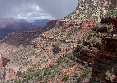
View of the Supai Group from along the Bright Angel Trail on the Grand Canyon's South Rim.
Mississippian, Late* (local)
Chesterian, late* (local)
Pennsylvanian, Early*
Morrowan*
Pennsylvanian, Middle*
Atokan*
Desmoinesian?*
Pennsylvanian, Late*
Virgilian*
Permian, Early*
Wolfcampian*
Early Pennsylvanian to Early Permian -
315-285 million years (age used by National Park Service; Mathis and Bowman, 2005)
Basin and Range province*
Black Mesa basin*
Plateau sedimentary province*
Salton basin*
Great Basin province*
AZ(n)*
CA(se)*
NV(s)*
UT(s)*
Not designated. Named for village of Supai on Cataract Creek, Coconino Co., AZ (Darton, 1910). Type section designated in Havasu Canyon near village of Supai on Cataract Creek, Coconino Co., AZ (Darton, 1910; McKee, 1975)
Group rank (alphabetical): Esplanade Sandstone (AZ*), Manakacha Formation (AZ*), Pakoon Limestone (AZ), Watahomigi Formation (AZ*), Wescogame Formations (AZ*).
Named as lower formation of Aubrey Group (Darton, 1910). Contacts revised (Noble, 1923). Areal limits (Hewett, 1931). Revised, Packard Ranch and Oak Creek Members named (Jackson, 1951). Areal limits (Hewett, 1956). Revised, divided into Amos Wash (new), Big A Butte (new), Fort Apache Limestone (assigned), and Corduroy (new) Members (Winters, 1963). Contacts revised (Pierce, 1964). Revised, divided into three informal and Cibecue (new) and Fort Apache Members (Finnell, 1966). Revised (McKee, 1975). Contacts revised; Areal limits (Hamilton, 1982). Overview (Weir and others, 1989). Areal limits (Blakey, 1990). Age modified locally (where Surprise Canyon Formation underlies the Watahomigi Formation of the Supai) on basis of conodont biostratigraphy.
Supai Group (Lower Permian, Pennsylvanian, and Upper Mississippian)—Includes, in descending order, Esplanade Sandstone (Lower Permian), Wescogame Formation (Upper Pennsylvanian), Manakacha Formation (Middle Pennsylvanian), and Watahomigi Formation (Lower Pennsylvanian and Upper Mississippian) as defined by McKee (1975, 1982). Age of Watahomigi redefined by Martin and Barrick (1999). Divided into Esplanade Sandstone and the Wescogame, Manakacha, and Watahomigi Formations, undivided.
Esplanade Sandstone (Lower Permian)—Light-red and pinkish-gray, cliff-forming, fine- to medium-grained, medium-bedded [3–10 ft (1–3 m)], well-sorted calcareous sandstone. Includes intrabedded dark-red, thin-bedded, crumbly, slope-forming siltstone in upper and lower parts. Consists of an upper cliff and slope unit in western two-thirds of map area, and a middle cliff unit and a lower slope unit throughout map area. In western two-thirds of map area, the upper cliff and slope unit contains thin-bedded slope-forming sandstone and siltstone similar to Hermit Formation capped by cliff of thick-bedded, low-angle cross-bedded, red and white sandstone; entire unit thins and pinches out eastward in eastern third of map area. Maximum thickness of upper cliff and slope unit about 220 ft (67 m), western edge of map. Middle cliff unit forms a prominent cliff whose upper surface forms the “Esplanade Bench” in western two-thirds of map area, and a prominent cliff in eastern third of map area. Unit consists of light-red, medium-grained, medium- to thick-bedded sandstone and calcareous sandstone in upper half, and mostly flat, massive, low-angle cross-bedded sandstone sets and calcareous sandstone beds in lower half. Cross beds are small- to medium-scale, planar low-angle and highangle sets. Cross-bedded calcareous sandstone is most common in western half of map area, lesser calcite in eastern half. Middle cliff unit averages about 250 ft (75 m) thick in western half of map area, thinning to about 200 ft (60 m) in eastern half. Lower slope unit consists of alternating layers of light-red, flat-bedded sandstone interbedded with dark-red siltstone and mudstone and gray, thinbedded limestone. Lower slope unit averages about 80 ft (25 m) thick in western half of map area, thickening to about 100 ft (30 m) in eastern half. Unconformable contact with underlying Wescogame Formation marked by erosion channels as much as 50 ft (15 m) deep filled with limestone conglomerate; average channel depth about 35 ft (11 m). Overall, the Esplanade averages about 550 ft (167 m) thick in western half of map area, thinning to less than 300 ft (90 m) in eastern half, Wescogame (Upper Pennsylvanian), Manakacha (Middle Pennsylvanian), and Watahomigi Formations (Lower Pennsylvanian and Upper Mississippian), undivided.
Wescogame Formation—Light-red, pale-yellow, and light-gray upper slope unit and lower cliff unit. Upper slope unit consists mainly of dark-red, fine-grained siltstone and mudstone interbedded with light-red, coarse-grained, calcareous sandstone and dolomitic sandstone, siltstone, mudstone, and conglomerate. Lower cliff unit consists mainly of light-red to gray, high-angle, large- and medium-scale, tabular-planar, cross-bedded sandstone and calcareous sandstone sets as much as 40 ft (12 m) thick. Includes interbedded dark-red, thin-bedded siltstone in upper part of cliff. Cross-bed sets contain large footprints of four-footed vertebrate animals in eastern part of map area. Unconformable contact with underlying Manakacha Formation marked by unconformity of erosion channels as much as 80 ft (24 m) deep in western part of map area, and less than 30 ft (10 m) deep in eastern part of map area. Channels commonly filled with limestone/chert conglomerate. The Wescogame thickens slightly from west to east, averaging about 130 ft (40 m) in western part of map area and about 150 ft (45 m) in eastern part Manakacha Formation—Light-red, white, and gray upper slope unit and lower cliff unit of sandstone, calcareous sandstone, dark-red siltstone, and gray limestone. Upper slope unit consists mainly of shaley siltstone and mudstone with minor interbedded, thin-bedded limestone and sandstone. Carbonate content of upper slope unit increases westward to form numerous ledge-forming, thin- and medium-bedded limestone beditors Upper slope unit is about 100 ft (30 m) thick in eastern half of map area, decreasing to less than 60 ft (18 m) thick in western half. Lower cliff unit is dominated by grayish-red, medium- to thick-bedded, crossbedded calcareous sandstone, dolomite, and sandy limestone. Lower cliff unit is about 60 ft (18 m) thick in eastern part of map area, thickening to about 100 ft (30 m) in western part. Carbonate content of lower cliff unit increases westward across map area, forming numerous gray limestone ledges. Unconformable erosional contact between the Manakacha and underlying Watahomigi Formation approximately marked at base of lower sandstone cliff of the Manakacha; erosional relief generally less than 3 ft (1 m) and wavy unconformable surface. Overall thickness averages about 200 ft (60 m) throughout map area.
Watahomigi Formation—Gray and purplish-red, slope-forming limestone, siltstone, mudstone, and conglomerate. Forms an upper ledge/slope unit and a 7 lower slope unit. Upper ledge/slope unit consists of alternating gray, thin-bedded cherty limestone ledges interbedded with purplish-gray siltstone and mudstone; limestone beds contain Lower Pennsylvanian conodont fossils (Martin and Barrick, 1999); red chert lenses and nodules common. Includes limestone chertpebble conglomerate at base, locally containing Lower Pennsylvanian fossils. Upper ledge/slope unit averages about 70 ft (21 m) thick throughout map area. Lower slope unit consists mainly of purplish-red mudstone and siltstone, interbedded with thin-bedded, aphanitic to granular limestone in upper part with red chert veins and nodules. Conodonts in lower thin limestone beds are Upper Mississippian (Martin and Barrick, 1999). Unit includes purple siltstone and gray limestone interbedded with conglomerate that fill small erosion channels cut into either Surprise Canyon Formation (Ms) or Redwall Limestone (Mr). Purple shale and mudstone of lower slope unit unconformably overlies the gray Redwall in majority of map area. Contact with the Surprise Canyon is often based on color change from purple mudstone of the Watahomigi to dark-red mudstone of the Surprise Canyon. Unit averages about 100 ft (30 m) thick along eastern edge of map area, thickening to about 200 ft (60 m) along western edge.
References
Darton, N.H., 1910, A reconnaissance of parts of northwestern New Mexico
and northern Arizona: U.S. Geological Survey Bulletin, 435, 88 p., (incl.
geologic map, scale 1:1,000,000).
Noble, L.F., 1923, A section of the Paleozoic formations of the Grand Canyon at the Bass Trail, IN Shorter contributions to general geology, 1922: U.S. Geological Survey Professional Paper, 131-B, p. B23-B73.
Hewett, D.F., 1931, Geology and ore deposits of the Goodsprings quadrangle, Nevada: U.S. Geological Survey Professional Paper, 162, 172 p., (incl. geologic map, scale 1:62,500).
Jackson, R.L., 1951, Stratigraphic relationships of the Supai formation of central Arizona: Plateau, v. 24, no. 2, p. 84-91.
Hewett, D.F., 1956, Geology and Mineral Resources of the Ivanpah Quadrangle, California and Nevada: U.S. Geological Survey Professional Paper, 275, 172 p., (incl. geologic map, scale 1:125,000).
Winters, S.S., 1963, Supai Formation (Permian) of eastern Arizona: Geological Society of America Memoir, 89, 99 p.
Pierce, W.G., 1964, Internal correlation of the Permian DeChelly Sandstone-Defiance Plateau, Arizona; contributions to the geology of northern Arizona: Museum of Northern Arizona Bulletin, no. 40, p. 15-32.
Finnell, T.L., 1966, Geologic map of the Cibecue quadrangle, Navajo County,
Arizona: U.S. Geological Survey Geologic Quadrangle Map, GQ-545, 1 sheet,
scale 1:62,500.
Martin, H., and Barrick, J.E., 1999, Conodont biostratigraphy, Chapter F, in Billingsley, G.H., and Beus, S.S., editors, Geology of the Surprise Canyon Formation of the Grand Canyon , Arizona : Flagstaff , Ariz. , Museum of Northern Arizona Press, Bulletin no. 61, p 97-116.
McKee, E.D., 1975, The Supai Group-Subdivision and nomenclature: U.S. Geological Survey Bulletin 1395-J, p. 1-11.
McKee, E.D., 1982, The Supai Group of Grand Canyon : U.S. Geological Survey Professional Paper 1173, 504 p.
Hamilton, W., 1982, Structural evolution of the Big Maria Mountains, northeastern Riverside County, southeastern California, IN Frost, E.G., and Martin, D.L., editors, Mesozoic-Cenozoic tectonic evolution of the Colorado River region, California, Arizona, and Nevada; Anderson-Hamilton volume: San Diego, CA, Cordilleran Publishers, p. 1-27, Published in conjunction with the Geological Society of America symposium and field trip, April, 1982.
Weir, G.W., Ulrich, G.E. and Nealey, L.D., 1989, Geologic map of the Sedona 30' x 60' quadrangle, Yavapai and Coconino Counties, Arizona: U.S. Geological Survey Miscellaneous Investigations Series Map, I-1896, 1 sheet, scale 1:100,000.
Blakey, R.C., 1990, Stratigraphy and geologic history of Pennsylvanian and Permian rocks, Mogollon Rim region, central Arizona and vicinity: Geological Society of America Bulletin, v. 102, no. 9, p. 1189-1217.
Blakey, R.C., 1990, Supai Group And Hermit Formation. In: Beus, S.S.,
Morales, M., editors, Grand Canyon Geology, Oxford Uinversity Press, New
York, p. 147-182.
Billingsley, George H., 2000, Geologic Map of the Grand Canyon 30' by 60' Quadrangle, Coconino and Mohave Counties, Northwestern Arizona: U.S. Geological Survey Geologic Investigation Series I-2688, Available on-line at: http://pubs.usgs.gov/imap/i-2688/.).
Mathis, A. and Bowman, C., 2005, What's in a number? Numeric ages for rocks exposed within the Grand Canyon, Part 2: Nature Notes ( Grand Canyon National Park ), v. 21, no. 2, p. 1-5.