Esplanade Sandstone
Esplanade Sandstone*
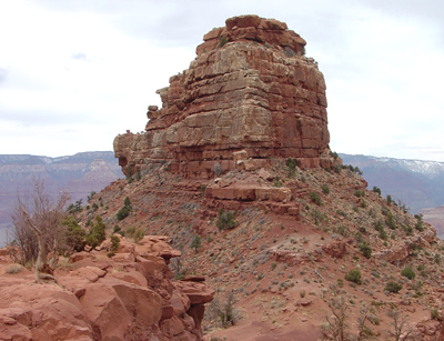
O'neill Butte along Grand Canyon's South Kaibab Trail consists of Esplanade Sandstone.
Permian, Early*
Wolfcampian*
Early Permian - 315 million years
(age used by National Park Service;
Mathis and Bowman, 2005)
Plateau sedimentary province*
AZ(n)*
Not designated (White, 1929).
Unit Name History:
First used (White, 1929). Revised, raised in rank from member to formation
of Supai Group (McKee, 1975). Overview (Billingsley, 1978). Areal limits,
name used in Grand Canyon region of northwest AZ; Overview (Billingsley,
1997).
Esplanade Sandstone (Lower Permian)—Light-red and pinkish-gray, cliff-forming, fine- to medium-grained, medium-bedded [3–10 ft (1–3 m)], well-sorted calcareous sandstone. Includes intrabedded dark-red, thin-bedded, crumbly, slope-forming siltstone in upper and lower parts. Consists of an upper cliff and slope unit in western two-thirds of map area, and a middle cliff unit and a lower slope unit throughout map area. In western two-thirds of map area, the upper cliff and slope unit contains thin-bedded slope-forming sandstone and siltstone similar to Hermit Formation capped by cliff of thick-bedded, low-angle cross-bedded, red and white sandstone; entire unit thins and pinches out eastward in eastern third of map area. Maximum thickness of upper cliff and slope unit about 220 ft (67 m), western edge of map. Middle cliff unit forms a prominent cliff whose upper surface forms the “Esplanade Bench” in western two-thirds of map area, and a prominent cliff in eastern third of map area. Unit consists of light-red, medium-grained, medium- to thick-bedded sandstone and calcareous sandstone in upper half, and mostly flat, massive, low-angle cross-bedded sandstone sets and calcareous sandstone beds in lower half. Cross beds are small- to medium-scale, planar low-angle and highangle sets. Cross-bedded calcareous sandstone is most common in western half of map area, lesser calcite in eastern half. Middle cliff unit averages about 250 ft (75 m) thick in western half of map area, thinning to about 200 ft (60 m) in eastern half. Lower slope unit consists of alternating layers of light-red, flat-bedded sandstone interbedded with dark-red siltstone and mudstone and gray, thinbedded limestone. Lower slope unit averages about 80 ft (25 m) thick in western half of map area, thickening to about 100 ft (30 m) in eastern half. Unconformable contact with underlying Wescogame Formation marked by erosion channels as much as 50 ft (15 m) deep filled with limestone conglomerate; average channel depth about 35 ft (11 m). Overall, the Esplanade averages about 550 ft (167 m) thick in western half of map area, thinning to less than 300 ft (90 m) in eastern half, Wescogame (Upper Pennsylvanian), Manakacha (Middle Pennsylvanian), and Watahomigi Formations (Lower Pennsylvanian and Upper Mississippian), undivided.
References
White, D., 1929, Flora of the Hermit shale, Grand Canyon, Arizona: Carnegie Institution of Washington Publication, no. 405, 221 p.
McKee, E.H., 1975, The Supai Group; subdivision and nomenclature, IN Contributions to stratigraphy: U.S. Geological Survey Bulletin, 1395-J, p. J1-J7.
Billingsley, G.H., 1978, A synopsis of stratigraphy in the western Grand Canyon: Museum of Northern Arizona Research Paper, no. 16, 27 p.
Billingsley, G.H., 1997, The Permian clastic sedimentary rocks of northwestern
Arizona, IN Maldonado, Florian, and Nealey, L.D., editors, Geologic studies
in the Basin and Range-Colorado Plateau transition in southeastern Nevada,
southwestern Utah, and northwestern Arizona, 1995: U.S. Geological Survey
Bulletin, 2153, p. 106-124.
Billingsley, George H., 2000, Geologic Map of the Grand Canyon 30' by 60' Quadrangle, Coconino and Mohave Counties, Northwestern Arizona: U.S. Geological Survey Geologic Investigation Series I-2688, Available on-line at: http://pubs.usgs.gov/imap/i-2688/.)
Mathis, A. and Bowman, C., 2005, What's in a number? Numeric ages for rocks exposed within the Grand Canyon , Part 2: Nature Notes ( Grand Canyon National Park ), v. 21, no. 2, p. 1-5.