Maps of San Diego County Region |
|
| This web page provides access to selected maps that were generated by combining a variety of data layers on The National Map - an on-line map geographic information system developed by the U.S. Geological Survey. The maps provided below are small small versions to much larger maps derived from The National Map Viewer and then were compiled and edited using Adobe Photoshop. Click on the map or the links provided to see the much larger version of each map. |
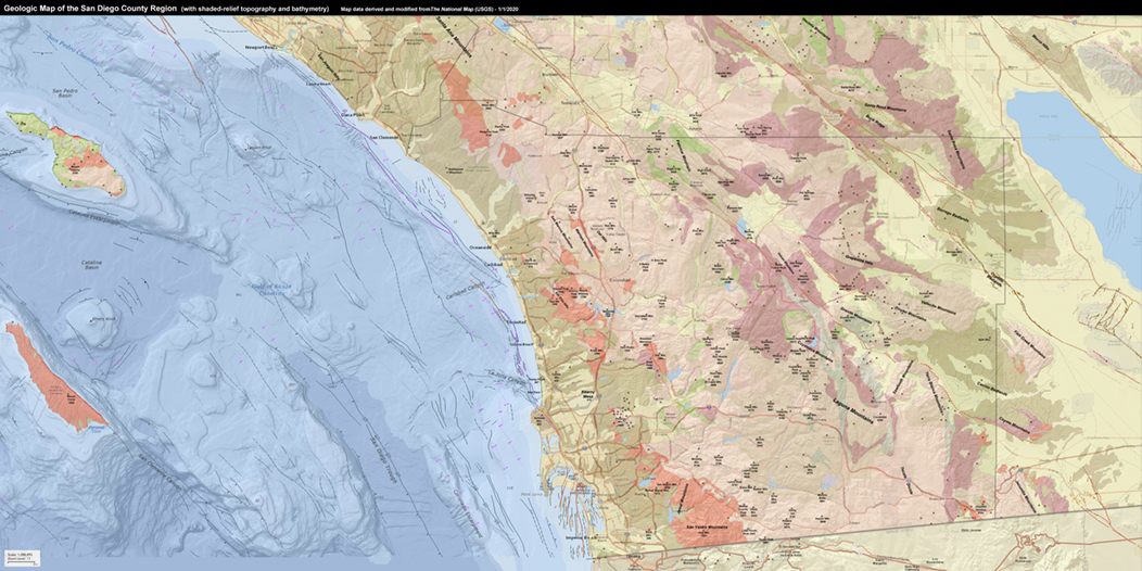
Geologic Map of the San Diego Region (with shaded-relief topography and bathymetry) |
 |
| Click here for a larger view of the map (large file: ~20 megabytes) |
Click here to see the Geologic Map Legend (guide to map colors and symbols). |
| Examine the larger version of this map to see detail including the location of faults, both onshore and offshore. This map combines layers of data from The National Map including generalized geologic map data for California, ocean bathymetry, and shaded-relief topography. Quaternary earthquake fault lines (age designated by color) has been added. The location of mountain peaks (with names and elevation data) have been added for reference information. Note that more detailed geologic maps of the coastal region can be viewed on these two websites: Oceanside and San Diego geologic quadrangle maps. |
| Geologic History of San Diego County (by Michael J. Walawender) provides an excellent summary of the regional geology and geologic history of the greater San Diego Region. This 15 page report (.pdf document) includes useful illustrations, maps, photographs, and a glossary. |
Geologic Map of the San Diego Region with Highways (with topography and bathymetry) |
 |
| Click here for a larger view of the map (large file: ~20 megabytes) |
Click here to see the Geologic Map Legend (guide to map colors and symbols). |
| This map includes the same geologic map information as the map above, however, the geologic map layer was made more transparent to show highway and city information to be visible. This map combines layers of data from The National Map including generalized geologic map data for California, ocean bathymetry, and major roads and highways on a background color shaded-relief topography. Quaternary earthquake fault lines (age designated by color) has been added. The location of mountain peaks (with names and elevation data) have been added for reference information. |
Color Shaded Relief Map of the San Diego County Region (with topography and bathymetry) |
 |
| Click here for a larger view of the map (large file: ~20 megabytes) |
| This map combines the National Geographic color-shaded relief map layer with the ocean bathymetry shaded relief map layer derived from The National Map data sets. This map layer shows the locations roads, cities and towns, reservations, wilderness areas, mountain ranges, and other physiographic features. |
Satellite Imagery Map of the San Diego County Region (with ocean bathymetry added) |
 |
| Click here for a larger view of the map (large file: ~20 megabytes) |
| This map combines a USGS satellite imagery map layer with the ocean bathymetry shaded relief map layer derived from The National Map data sets. Name of mountain ranges and mountain peaks (with elevation data) have been added as reference information. |
Public Land Survey System Map of the Greater San Diego County Region |
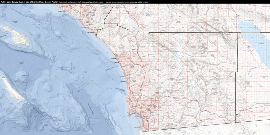 |
| Click here for a larger view of the map (large file: ~20 megabytes) |
| This map combines the U.S. Bureau of Land Management - Public Land Survey System (PLSS) with a regional topographic map layer (and ocean bathymetry and topographic shaded relief) derived from The National Map. The U.S. Government authorized the public land survey of the greater San Diego region starting in 1852. The initial point for the survey began in San Bernardino where the principal meridian and base line for the regional survey was established. The survey was initiated for township and range designations, primarily for land ownership and stewardship purposes. In general, the property boundaries of established towns and ranchos in the region remained the same at the time of the survey. |
Land Management Map of the Greater San Diego County Region |
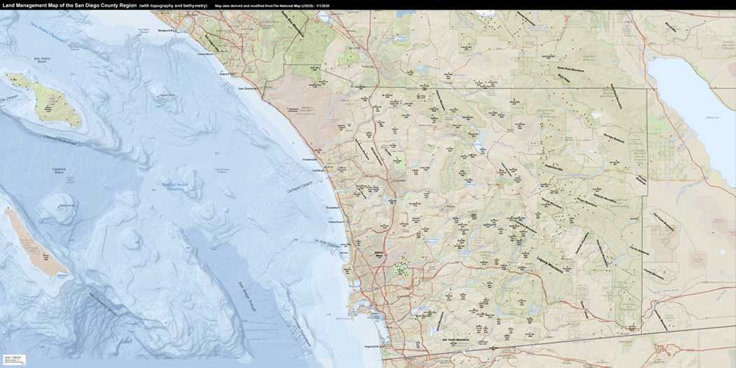 |
| Click here for a larger view of the map (large file: ~20 megabytes) |
This map show the distribution of public lands (parks, national forests, municipal property boundaries, and lands with restricted public access [Indian and military reservations]. It is interesting to note that less than half the land in San Diego County is designated for private ownership. This map also includes roads, mountain ranges and mountain peak for reference orientation.
|
|