
Geology Field Trip Destinations in San Diego County |
| This website lists selected field trip destinations available for students in for geology, earth science, and oceanography class at MiraCosta College in northern San Diego County. Some field trips (below) may be scheduled during class time - some for Oceanside campus classes; some for San Elijo campus classes. Other field trips are scheduled for dates on Fridays and Weekends. Students are not obligated to attend these trips, but they may count for assignment credit for those who attend (insructor's choice). Note that potential hazards exist on any field trip. Traveling to the site of the field trip is perhaps the greatest risk. Common hazards on field trips include sun burn, heat exhaustion, tripping and falling, insect bites, and exposure to poison oak and other allergens. Rattlesnakes and other wildlife can be encountered practically anywhere, especially along nature trails. Please note! Plan ahead and check to be sure it is LOW TIDE before planning a trip to the beach localities listed below. Be aware that it is never safe to go near the base of actively-eroding sea cliffs, and it is always important to be wary of rouge waves and dangerous surf conditions. |
Click on images for a larger view. |
| Geologic Maps in coastal San Diego County (Maps modified from state and federal geologic maps) - very useful resources for studying regional geology! Oceanside 1:100,000 scale map and 1:24,000 scale maps (coastal northern San Diego County) San Diego 1:100,000 scale map and 1:24,000 scale maps (coastal southern San Diego County) |
| San Elijo State Beach - this is the closest beach to MiraCosta College San Elijo Campus. Take Manchester Avenue west (past I-5) and continue when it becomes San Elijo Avenue. There is ample free parking along the road where San Elijo Avenue crosses Chesterfield Drive. Park and wall across the bridge over the train railroad tracks and cross the Coast Highway at the stop light. Enter the park at the trail near the "Cardiff Kook" statue. Cross the campground at San Elijo State Beach and take the stairs down to the beach. The field trip is to examine the sea cliff, processes forming the beach, and the entrance (tidal delta) to the San Elijo Lagoon. Plan to go at LOW TIDE only! The beach below the sea cliffs many be inaccessible during low tide. There may be strong rip tides near the mouth of the lagoon. | 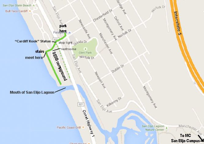 |
| San Elijo Lagoon Nature Center - This is also near the San Elijo Campus. The theme here is how lagoon valley formed over time and how marine terrace formation are connected to sea level changes. Across the lagoon on the south side you can see several marine terraces, rising in elevation inland, all built up with houses. A short walking trail from the interpretive nature center takes you out into the lagoon where both coastal plants and animal life are commonly accessible. | 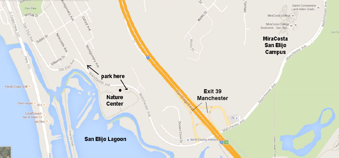 |
| Del Mar Dog Beach is an exceptional place to examine sea cliffs, coastal erosion, Eocene-age rock formations with fossils, and wave tidal processes shaping the entrance to San Dieguito Lagoon. There is hourly parking along the Coast Highway (101), but there is also free parking on Via de la Valle Road near the intersection with the Coast Highway near the park. This is an off-leash dog area, and is a lot of fun to watch the dogs (and people). However, running groups of dogs can crash into you. If you have a fear of dogs, don't attend this field trip. Plan to go at LOW TIDE only! The beach below the sea cliffs many be inaccessible during low tide. There may be strong rip tides near the mouth of the lagoon. See Del Mar Tides information to plan a trip. Yes you can bring your dog! Dogs can be off leash after Labor Day to Memorial Day. A trial leads up stairs to North Beach Overlook which provides an excellent view south to La Jolla's marine terraces. | 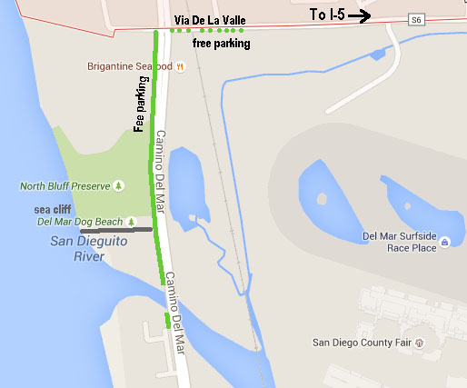 |
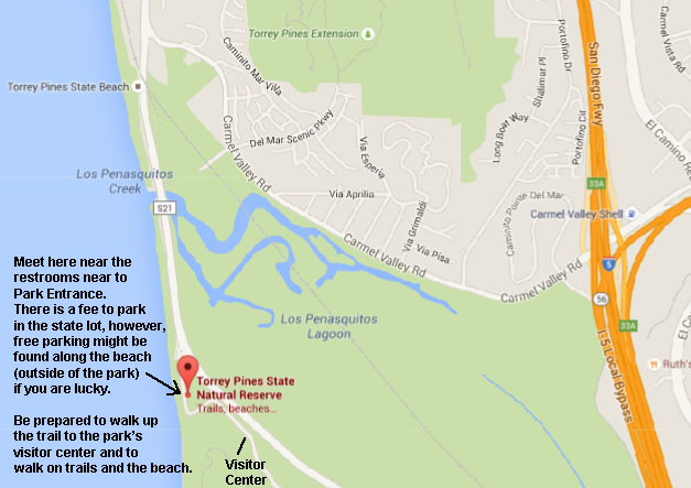
| Torrey Pines State Nature Preserve (TorreyPines.org) Geology: describes rock formations, cliffs, erosion, fossils, faults, and marine terraces. Seashore and Ocean: describes rocky shore biota, sandy shore biota, marine mammals, Flat Rock, and Los Penasquitios Lagoon. Plan to hike up to the Visitor Center and cliff bluff trails for exceptional views. This is a wonderful place to spend a day hiking and checking out the sea cliffs and beaches. Parking is free along the beach, but is usually packed early. Fee parking is available at the State Park lots. |
 |
| South Carlsbad State Beach - This is an excellent beach to study beach processes and sea cliff erosion. An erosional unconformity with a elevated marine terrace gravel on top is well exposed. Layered black sand beds are well exposed south of the parking area in the sea cliff. From MCC Oceanside Campus, the most direct route is the take Highway 78 west to I-5 South. Follow I-5 to the Palomar Airport Road Exit (Exit 47). Head west on Palomar Airport Road (careful to choose the correct lane to proceed toward Carlsbad Road South (you will be driving south with the seacliff on your right). Proceed 1/2 mile to the parking area for South Carlsbad State Beach. | 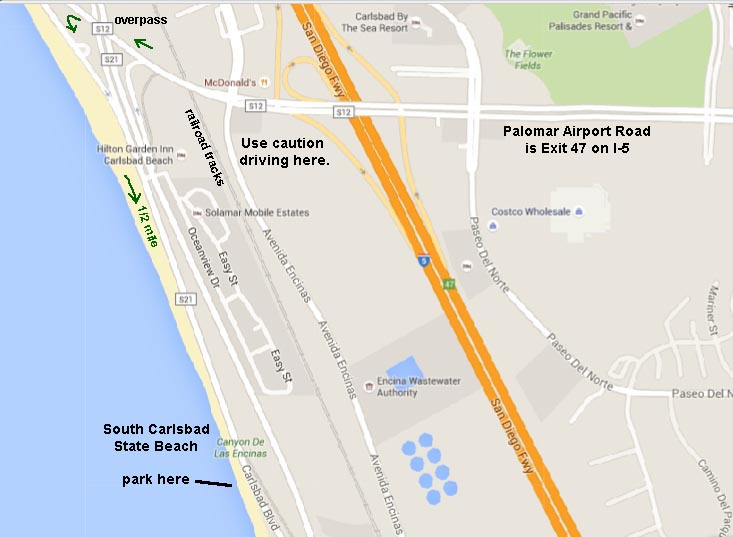 |
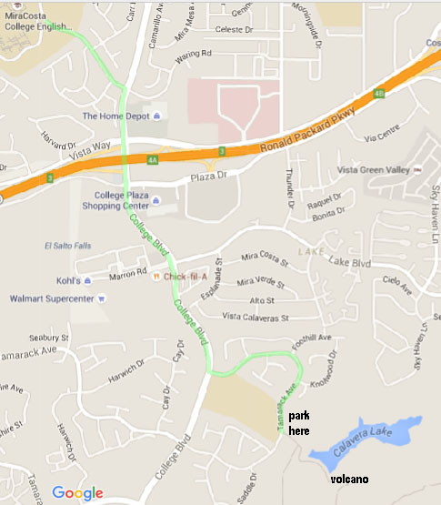
| Calavera Hills Nature Preserve is an excellent field trip destination near the MiraCosta College Oceanside Campus. This open-space preserve park is host to an ancient volcano that erupted along the coast sometime between 13-18 million years ago. The internal features of the old volcano are exposed in a cut used to mine rock in the construction of Calavera Lake Dam. Follow College Avenue south for about 1 mile (south of Highway 78). Turn left on Tamarack Avenue and follow the road down through the neighborhood until you see the trailhead that leads to the dam. The volcano is on the opposite side of the dam. There is much to examine here! |
 |
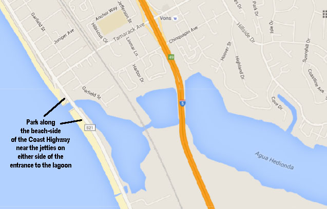
Tamarack Beach, Carlsbad: You have to approach by car from the north in order to park (along the beach side of Highway 101). The two pairs of jetties that bracket the beach illustrate the dominant southward longshore drift. The beaches are noticeably wider on the north sides of both jetties, and the beach between the jetties widens from north to south. The southward drift of sand regularly plugs the jetty entrances to Agua Hedionda Lagoon, requiring frequent dredging. This area is a good location for beach profiling excursions to measure seasonal changes in the beach. |
 |
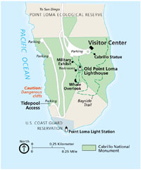
| Tide Pools at Cabrillo Point: Cabrillo National Monument Life in the Rocky Intertidal Zone This brochure identifies many of the local benthic life forms found in the tide pools. We have requested a permit from the National Park Service to gain access to the Tide Pools area for a limited number of students and a date in mid october or november (to be announced). A National Park Service brochure recommends not going here on weekends or holidays due to road closure and parking limitations. |
 |
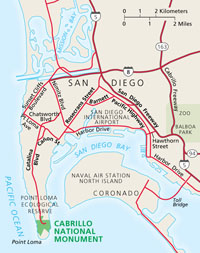 |
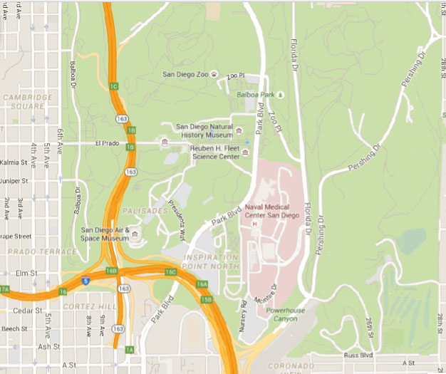
| San Diego Natural History Museum: Located in Balboa Park featuring exhibits, lectures, classes and field trips related to natural history for all ages. Exceptional regional fossil displays. Imax theatre presentations. Plan to send a day in Balboa Park! The cactus and rose garden next to the Natural History Museum are spectacular! There are many of the other museums in the park. Bring a picnic, and plan to spend the day! |
 |
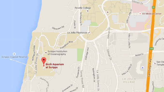
| Birch Aquarium Scripps Institute of Oceanography This aquarium and museum affiliated with the Scripps Institute and the University of California at San Diego in La Jolla, houses a 70,000-gallon tank of sea life and interactive aquatic displays. For discounted tickets for Birch Aquarium for college students: Click here |
 |
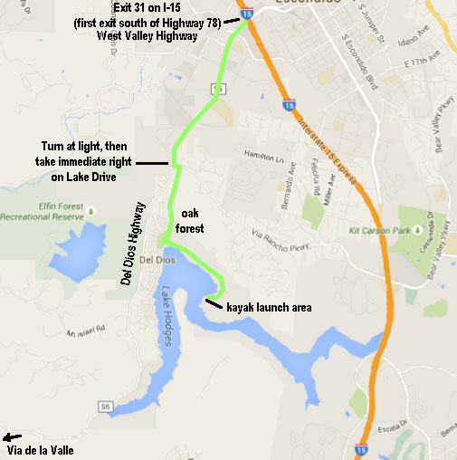
| Lake Hodges - Kayaking and Hiking This field trip requires a kayak (or a boat) - bring you own, or rent one. The destination is to kayak out to a wind "vortex" area created by a gap in a peninsula. It is an ideal location to study how wind influences wave and ripple patterns, how topography effects wind patterns, and how wildlife (particularly birds called Grebes) respond to wind patterns and upwelling. In addition, participants can paddle around to "Flag Beach" to participate in a half mile hike up to the "Flag pole" and get to examine some interesting geology, archeology, and biology along the way. Definitely plan to make a day of it if you can! Pack a lunch and bring lots to drink. This is a spectacular trip if you can pull it off. Lake Hodges is only open on Wednesdays and weekends, and is closed after Thanksgiving until early February when large numbers of birds winter on and around Lake Hodges. |
 |
| Oceanside Municipal Pier: One of the longest wooden piers on the West Coast at 1,942-feet. Mostly a place for fishermen, tourists and residents, but can be useful for studying wave periods, wave patterns, currents, beach erosion, local sea life, and shoreline management. There is plenty of parking but it's all pay. Watch how waves change as they slow and break. Looking down at the water within the surf zone often shows a longshore current, depending on swell direction. The Oceanside Jetty, visible in the distance to the north, is a major blocker of south-drifting sand, leading to sand depletion along North County beaches. A walk down the beach to the mouth of the San Luis Rey River and out and around Oceanside Harbor is a wonder way to spend a day! | 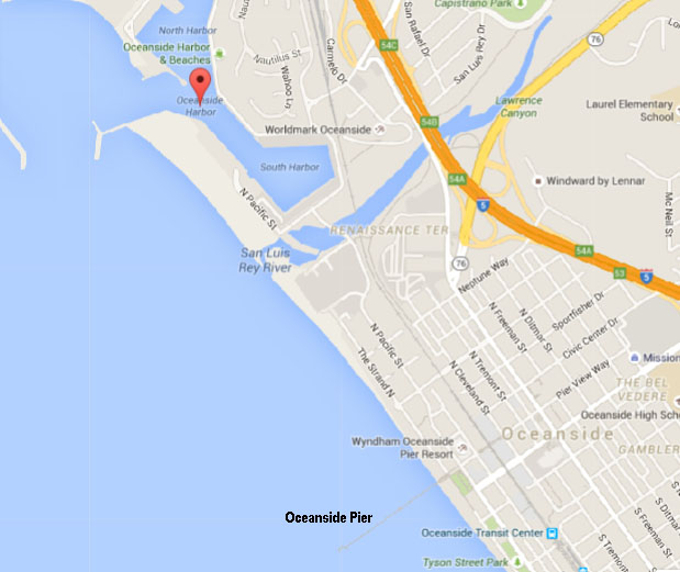 |
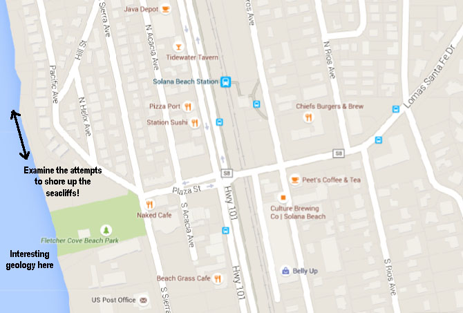
Fletcher Cove, Solana Beach: Lots of sea wall construction, good examples of bluff failure due to wave attack on faults and joints. Walking north you’ll pass a near continuous stretch of seawalls (dubbed “Solana Wall” by Surfrider); walking south you’ll pass seawalls, concrete plugs, and stretches of exposed bedrock (mostly Torrey Sandstone in this area). Interesting geologic exposures of unconformities and paleo-valley fill deposits exposed in the sea cliff at Fletcher Cove. Seaside Beach access, Solana Beach: This a is a half-mile north of Fletcher Cove, so if you walk south you see Solana Wall, and if you go north you see some older failing walls and plugs. Depending how much walking you want students to do, you could take in both areas above. |
 |
| Double Peak Park, San Marcos: Double Peak (elevation 1,644 feet) is the highest mountain in northern coastal San Diego County. The park located in the high peak area provides spectacular panoramic views in all directions. A short, easy walk connects the parking lot to the high peak. On a clear day it is possible to see distant snow-capped mountain ranges to the north (San Gabriel, San Bernardino, and San Jacinto Mountains), Palomar Mountain (ridge), and many other peaks and plateau regions of the Peninsular Ranges in San Diego County. The entire coastline from Dana Point (to the north) to Mexico, and many of the island offshore are visible on a clear day. Rocks exposed on Double Peak include ancient granite, basalt, and metamorphic rocks of Mesozoic age. |
 |
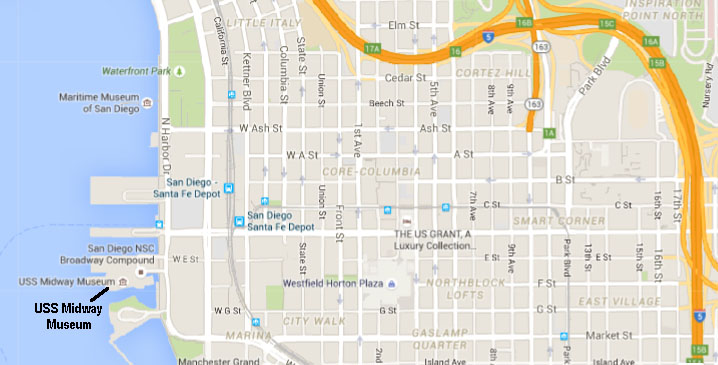
| USS Midway Museum The USS Midway Museum is located at 910 North Harbor Drive, San Diego, California, 92101, alongside Navy Pier. The trip is fairly pricey... $13 for students (with college ID), and then another $10 for parking (take the train!). Plan to get there early (it is open 10am-5pm), and get on a tour of the Chart Room asap, or you will have a long wait... Weekends and holidays are crowded. |
 |
Sea World - This can be turned into an OK fieldtrip if participants examine all the displays about sea life and that examine the science behind Seaworld. Although a commercial venture focused on entertainment, there are many science and environmental exhibits. Seaworld is a good destination for students with children.
|