
Oceanography 101 |
Return to class home page |
Chapter 5 - Ocean Basins |
| Bathymetry is the measure of depth of water in oceans, seas, lakes, and rivers. Bathymetry data is used to create maps (called "charts") of the seafloor. Bathymetric charts are the equivalent of topographic maps on land. In the past, the depth of water was measured by lowering weighted lines overboard. Sonar invented in the 1920s and works by reflecting sound waves off the ocean floor. SONAR (short for "SOund NAvigation & Ranging") is a system for detecting objects under water and for measuring the water's depth by emitting sound pulses and detecting or measuring their return after being reflected off the seafloor. |
Click on thumbnail images for a larger view. |
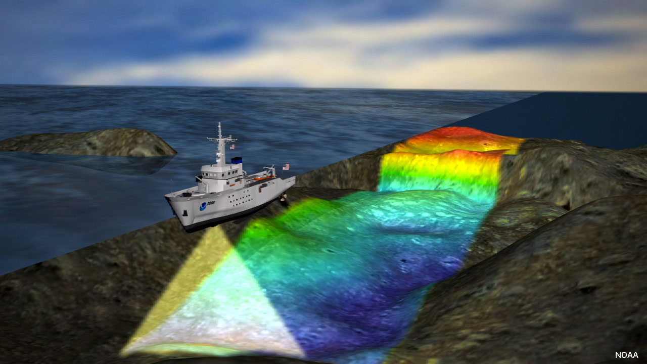 Fig. 5-1. Ship equipped with sonar equipment scanning the seafloor. |
Major provinces of the ocean floor• Continental margins - these are regions that extend from the coast across shallow shelf regions to the edge of continents where the seafloor descends into deep water.• Deep-ocean basins - This includes parts of the oceans where deep water prevails. Deep ocean basins cover the greatest portion of the Earth's surface. • Oceanic (mid-ocean) ridges - nearly 12,000 miles (20,000 km) of mountain belts run through ocean basins and are associated with divergent plate boundaries (spreading centers). Each of the major provinces are discussed in detail below. |
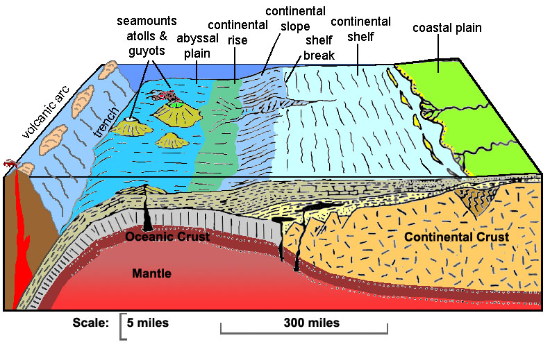 Fig. 5-2. Submarine landscape features associated with a continental margin to deep-ocean basin. |
Continental ShelfA continental shelf is a submerged nearshore border of a continent that slopes gradually and extends to a point of steeper descent to the ocean bottom. Continental shelves are submerged extension of the continent.Continental shelves typically have low relief: they usually have less than 1 degree of slope. Average is about one tenth of one degree. Continental shelves are influenced by a variety of geologic processes, particularly associated with the erosion and deposition of sediments on beaches, deltas, and carbonates (coral reefs). Shallow water coastal and shelf environments are particularly influenced by the impact of large storms. Continental shelves are commonly cut by submarine canyons. Continental resources are areas with important natural resources, particularly fisheries, but also oil and gas, and sand and gravel. During the peak of the last ice age, the world's continental shelves were mostly exposed coastal plain environments. A shelf break is a general linear trend that marks the boundary between the relatively flat continental shelf and the drop-off into deeper water on the continental slope. The shelf break generally follows the ancient shorelines that existed at the peak of the continental glaciation periods of the ice age when sea level was as much at 400 feet (120 meters) lower that present sea level. |
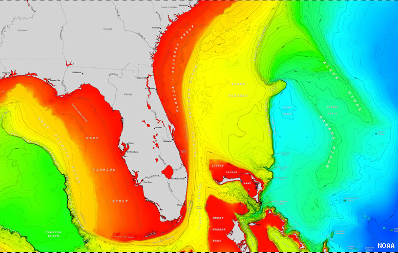 Fig. 5-4. The continental shelf around Florida (shown in red) gradually transitions to the continental slope (yellow and green). Florida displays features of a typical "passive continental margin" having wide coastal plains, wide continental shelves, and gentle slopes extending into deep water. |
Continental SlopeA continental slope is the slope between the outer edge of the continental shelf and the deep ocean floor. The continental slope is cut by submarine canyons in many locations. The continental slope marks the seaward edge of the continental shelf.Continental slopes typically follow the boundary between continental crust and oceanic crust. Continental slope range in steepness from 1 to 25 degrees, average is 4 degrees. • Pacific (active margin) average >5 degrees. • Atlantic (passive margin) average about 3 degrees Continental slopes are cut by submarine canyons. The dominant process influencing slopes are sediment deposition and erosion by turbidity currents (discussed below). |
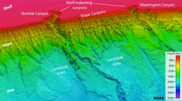 Fig. 5-5. The continental slope off the coast of Virginia is cut by numerous submarine canyons that drain sediments to the continental rise at the base of the slope. |
Continental RiseA continental rise is a wide, gentle incline from a deep ocean plain (abyssal plain) to a continental slope.A continental rise consists mainly of silts, mud, and sand, deposited by turbidity flows, and can extend for several hundreds of miles away from continental margins. Although it usually has a smooth surface, it is sometimes crosscut by submarine canyons extending seaward of continental slope regions. The continental rise is generally absent in regions where deep-sea trenches exist where subduction zones are active. Continental rises feature deep-sea fans. In appearance they are much like alluvial fans on land found along the fronts of mountain ranges. Deep-sea fans are accumulations of sediment deposited by turbidity currents (called turbidites) at the foot of the continental slope. Turbidites are underwater landslide deposits. Over time they build up the large deep-sea fans that coalesce to form the continental rise along some continental margins. |
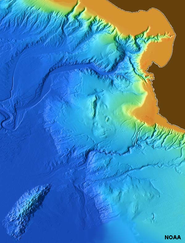
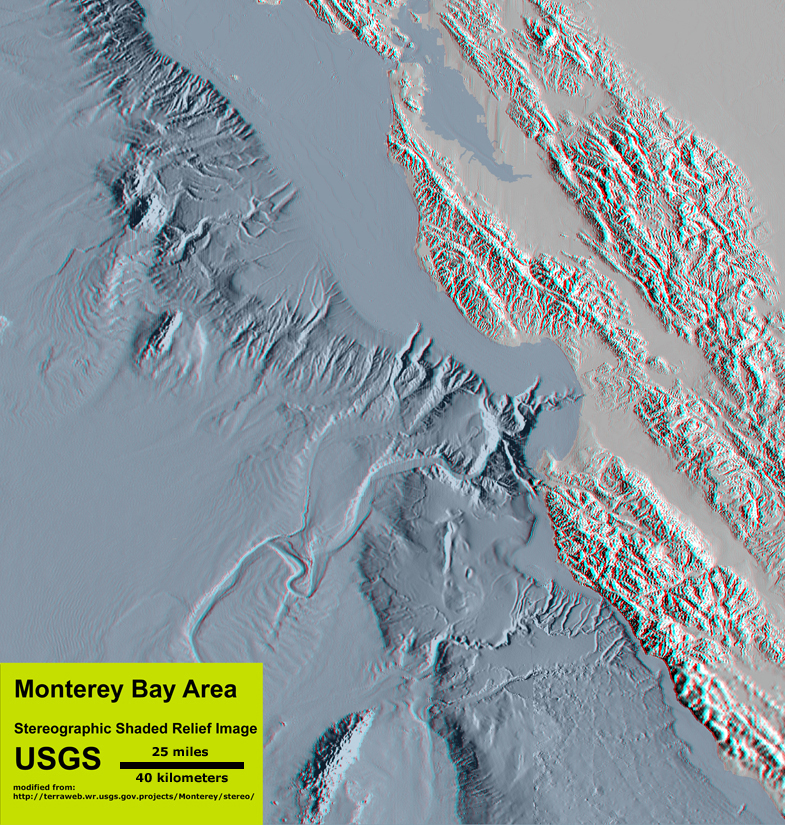 Fig. 5-6. Bathymetry of the Monterey Bay offshore region highlights the character of the continental slope and rise. |
Submarine CanyonsSubmarine canyons are similar to river gorges carved in mountainous regions on land, however they tend to be both much larger and deeper. Characteristics of submarine canyons include:• They generally form perpendicular to coastline. • They are commonly associated with zones of weakness such as a fault or a drowned river valley (canyons flooded by sea level rise). • They start on continental shelf and cut into (erode) shelf and upper slope, commonly near the mouth of a bay or river . • They are carved by undersea erosion processes associated with turbidity currents. Turbidity currents transport sediment into deep ocean basins via submarine canyons. • Turbidity currents moving down submarine canyons eventually slow down and deposit sediments on the continental rise as deep-sea fans. |
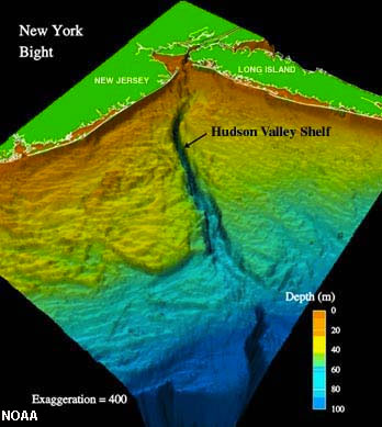 Fig. 5-7. Hudson Canyon offshore of New York City |
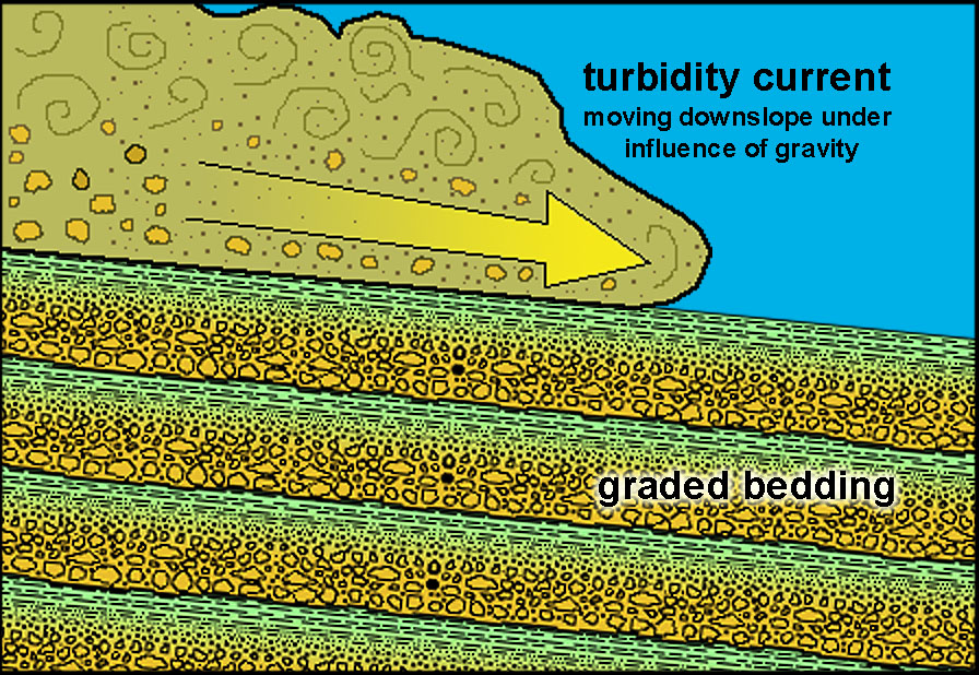
| Turbidity Currents and Development of Submarine Canyons and Fans A turbidity flows is a turbid, dense current of sediments in suspension moving along downslope and along the bottom of a ocean or lake. In the ocean, turbidity currents can be massive episodic events. They typically form and flow down through a submarine canyon (carved by previous turbidity flows) and accumulate near the base of the continental slope on deep-sea fans. Turbidity flows produces deposits showing graded bedding (Figure 5-8). Slowing turbid currents drop their coarser fractions first (gravel and sand) and the finer silt and clay fractions settle out last. A deep-sea fan is a fan- or delta-shaped sedimentary deposit found along the base of the continental slopes, commonly at the mouth of submarine canyons. Deep sea fans form from sediments carried by turbidity flows (density currents) that pour into the deep ocean basin from the continental shelf and slope regions and then gradually settle to form graded beds of sediment on the sea floor. Deep-sea fans can extend for many tens to hundreds of miles away from the base of the continental slope and an coalesce into a broad, gently sloping region called a continental rise. Graywacke is a fine-to-coarse-grained sedimentary rock consisting of a mix of angular fragments of quartz, feldspar, and mafic minerals set in a muddy base (commonly called a "dirty sandstone or mudstone" because of its mixed size fractions). Graywacke is the general term applied to sediments deposited by turbidity flows, and they commonly show graded bedding. Graywacke is common in the Coast Ranges of California and other active continental margin regions. It is exposed on land where tectonic forces push up rocks that originally formed in the deep ocean (examples in Figures 5-10 to 5-11). "Turbidites" (deposits associated with turbidity flows) commonly appear as interbedded layers of sandstone and shale. Conglomerate typically occurs in thicker beds and were originally deposited as gravel and mud on ancient submarine fans closer to the mouths of submarine canyons or in channels carved into the seabed. |
 |
 |
| Fig. 5-8. Turbidity flows are essentially underwater landslides or density-driven currents. Sediments laden with sediment are heavier than clear seawater. | Fig. 5-9. Seas stacks composed of submarine channel deposits (mostly conglomerate) exposed at Gazos Creek State Beach, California | |
 |
 |
|
| Fig. 5-10. Cretaceous age turbidites exposed on Loma Prieta Peak, Santa Cruz Mountain, California | Fig. 5-11. Cretaceous age turbidites (turbidity current deposits) at Bean Hollow State Beach, California |
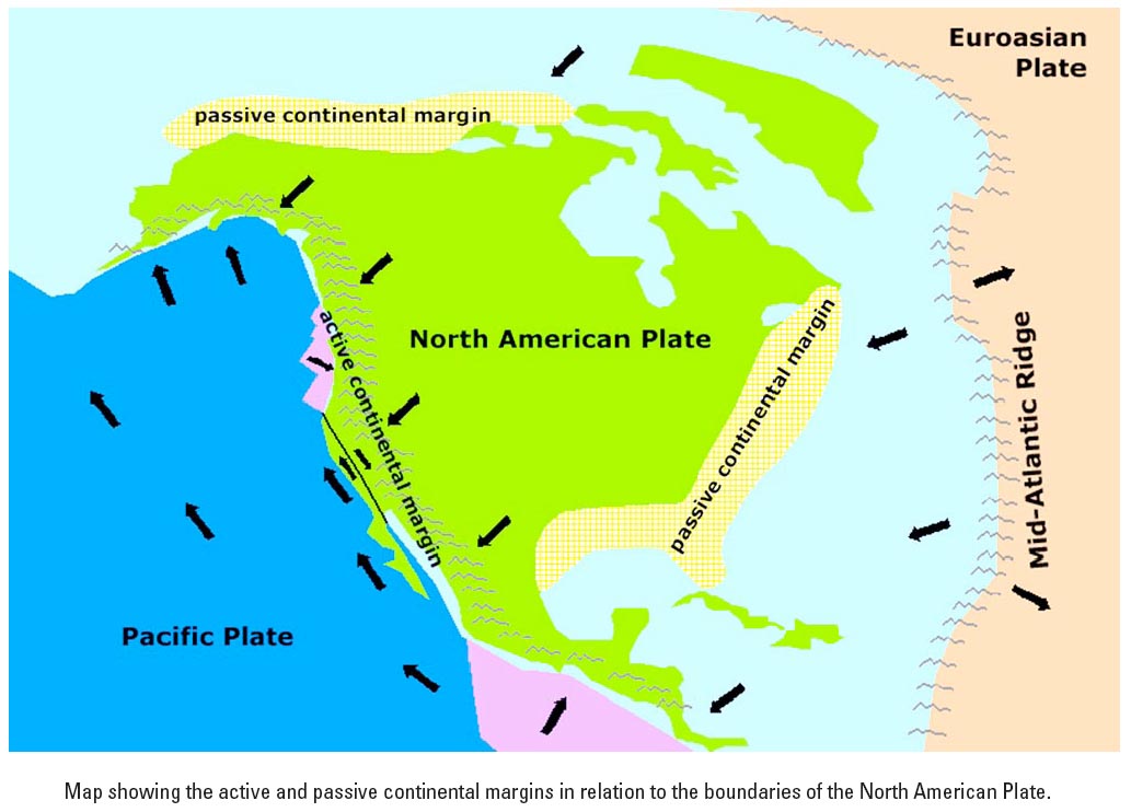
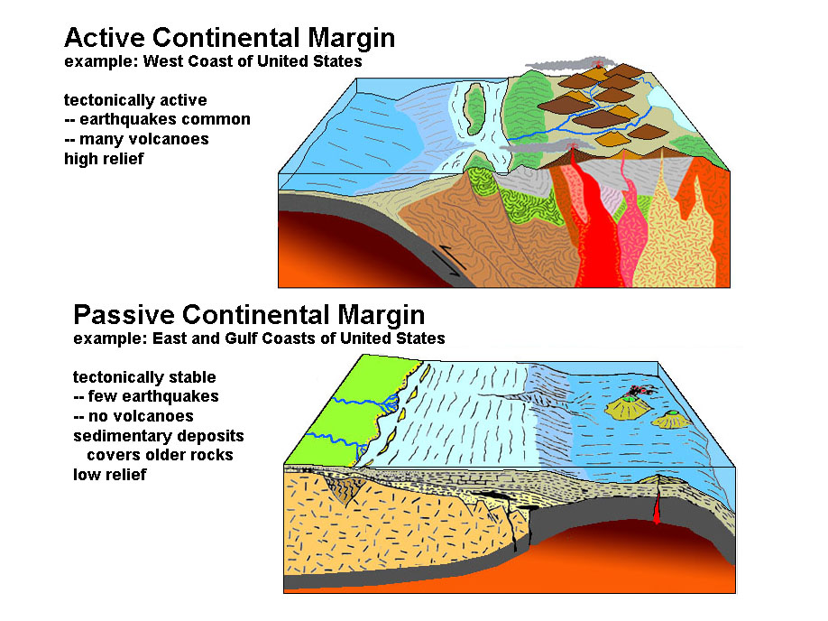
"Active" vs. "Passive" Continental MarginsContinental margins typically fall into two classes: "active" and "passive."An active continental margin is a coastal region that is characterized by mountain-building activity including earthquakes, volcanic activity, and tectonic motion resulting from movement of tectonic plates. Characteristics of active continental margins include: • Found on mostly convergent plate boundaries • Continental slope descends abruptly into a deep-ocean trench (no continental rise) • Located primarily around the Pacific Ocean The West Coast of the United States is an active margin that is characterized by rugged coastlines with narrow beaches and steep sea cliffs. Passive continental margins occur where the transition between oceanic and continental crust which is not an active plate boundary. Examples of passive margins are the Atlantic and Gulf coastal regions which represent setting where thick accumulations of sedimentary materials have buried ancient rifted continental boundaries formed by the opening of the Atlantic Ocean basin. The Atlantic Coast of the United States is characterized by wide beaches, barrier islands, broad coastal plains (see features discussed below). Emergent and Submergent CoastsIn some regions around the world, tectonic forces are pushing rocks up along coastal regions, mostly in regions associated with active continental margins. There areas are called emergent coasts and display features including sea cliffs and marine terraces (see below). Where sea level is rising faster than land is rising, or where coastal areas are sinking, it is called a submergent coast. Submergent coasts are associated with passive continental margins with wide coastal plains and continental shelves. Estuaries are associated with submergent coastlines formed when sea level rises and floods existing river valleys. Active margins can have both emergent and submergent coastlines in close proximity to each other. |
 |
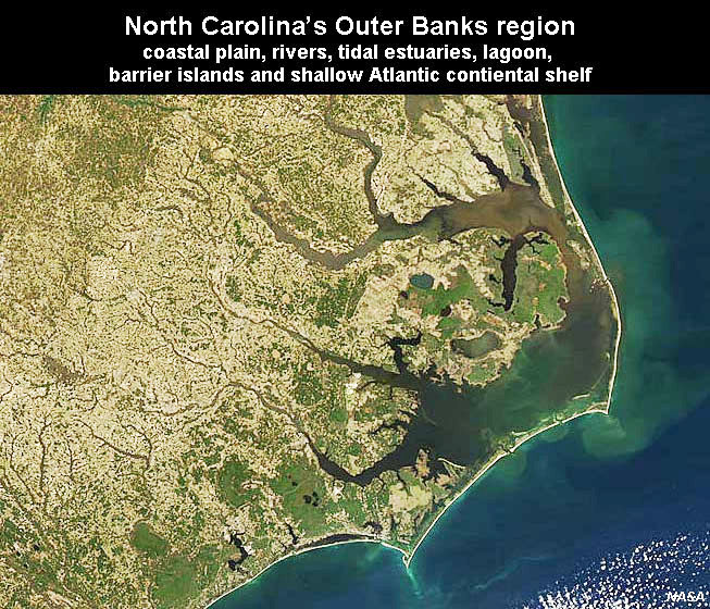 |
| Fig. 5-12. Active and passive margins of North America. The East Coast and North Slope are now passive margin regions located within the greater North American Plate. | Fig. 5-13. Passive margin: North Carolina's Outer Banks region showing coastal plain, rivers, tidal estuaries, lagoon, barrier islands, and shallow Atlantic continental shelf | |
 |
 |
|
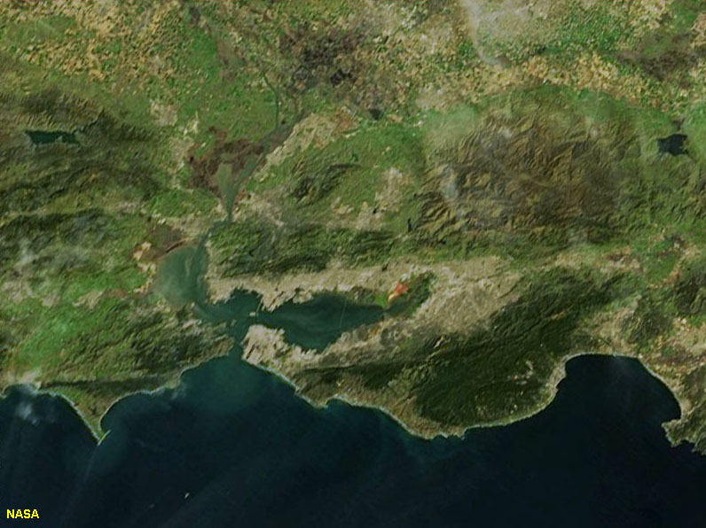
| Fig. 5-14. Active margin: San Francisco Bay and Monterey Bay region has actively rising coastal range mountains and sinking coastal basins | Fig. 5-15. Comparison of active and passive continental margins. Passive margins are on the trailing edge of a moving continental landmass. | |
Deep-Ocean BasinsDeep-ocean basins cover the greatest portion of the Earth's surface. Geographic features associated with deep-ocean basins include trenches, abyssal plains, ocean ridges and rises, and submarine mountainous regions.TrenchesTrenches are long, relatively narrow canyon-like features that run parallel to continental margins.They are the deepest parts of ocean basins. Most trenches are located in the Pacific Ocean. Trenches occur where mobile lithospheric plates plunge into the mantle (subduction zones). Trenches are associated with intense volcanic activity, usually in the form of volcanic arcs (or volcanic island chains) that develop above the descending side of the subducting plate associated with a trench. |
 Fig. 5-16. An animated view of part of the Marianas Trench. See a NOAA animation. Fig. 5-16. An animated view of part of the Marianas Trench. See a NOAA animation. |
Abyssal PlainsAn abyssal plain is an underwater plain on the deep ocean floor, usually found at depths between 4500 and 6000 meters that extends from the continental rise (continental Lithogenous sediments accumulate along continental margins) to the distant deep ocean basin where continental-derived sediment deposition is not significant.Abyssal plains are large horizontal seafloor regions - typically some of the flattest places on the Earth's surface. Abyssal plains are underlain by oceanic crust that formed and moved away from spreading centers associated with mid-ocean ridges and rises. Because they are so far from land they have very slow sedimentation rates. Some places less than 1 cm per 1000 years. The dominant geologic process is "Planktonic rain" which blankets seafloor with organic sediments. |
 Fig. 5-17. Abyssal plains dominate the Pacific Ocean basin. |

 |
 |
 |
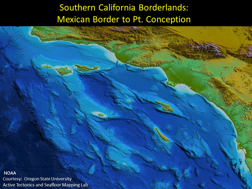 |
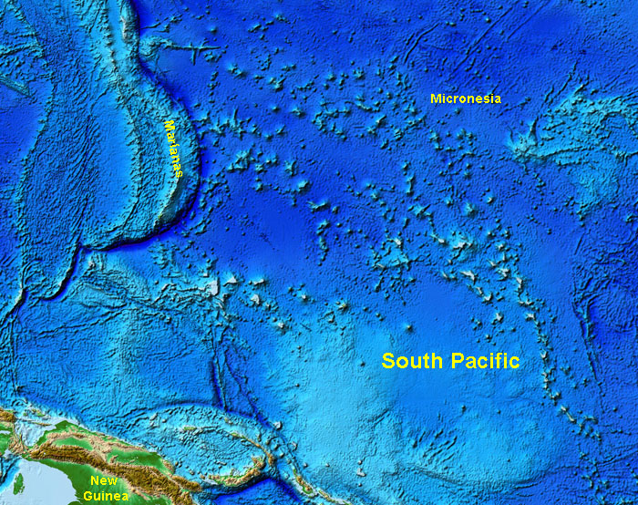
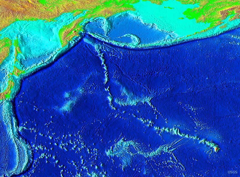
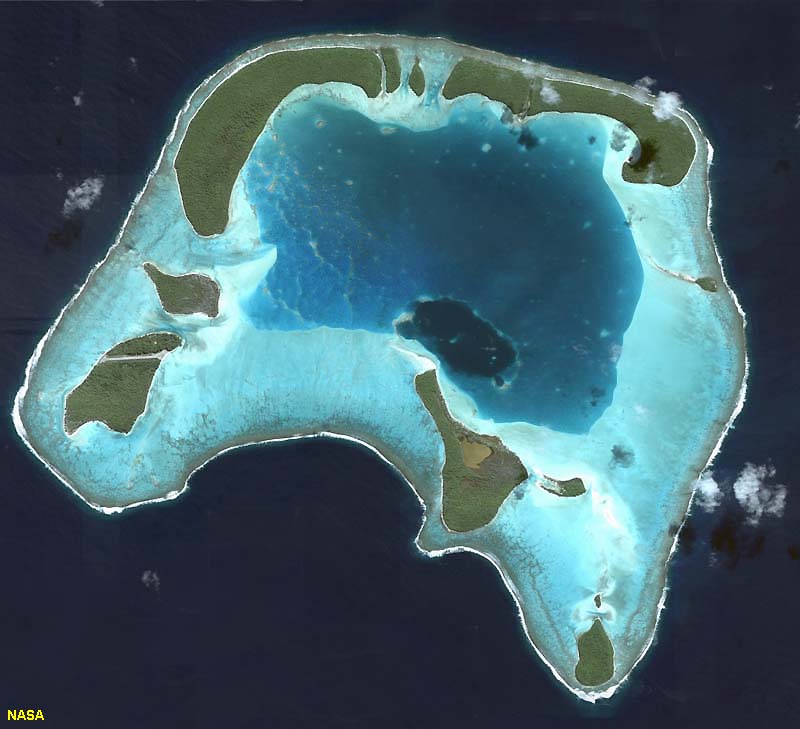
| Fig. 5-19. The South Pacific region has numerous islands, seamounts, atolls, and guyots. All of them started forming as undersea volcanoes. | Fig. 5-20. Hawaii is the youngest volcanic island of the Emperor Seamount Chain. Many of the older seamounts were once volcanic islands but are now atolls or guyots. | Fig. 5-21. A satellite view of an atoll displaying a fringing carbonate reef platform (with islands) surrounding an eroding central volcanic peak. Most atolls of the world are located in tropical regions of the South Pacific and Indian Oceans. | Fig. 5-22. Seamounts and islands offshore of southern California. Many of these features are associated with active faults that are moving great blocks of crust across the seafloor. |
Oceanic (Mid-Ocean) Ridges and RisesMid-ocean ridges (MORs) are broad, linear swells along divergent plate boundaries in ocean basins. They are associated with extensive faulting and small earthquakes, and along their crest there is high heat flow form new crust forming from the cooling of molten material derived from the mantle and remelting of the crust.Ocean Ridges are present in all ocean basins. They are the shallowest and youngest parts of deep ocean basins. Features associated with ocean ridges include volcanism (undersea volcanic features), hydrothermal vents, and undersea rift valley. As newly formed crust moves away from spreading centers, the crust gets older and layers of sediments thicken away from the mid-ocean ridges. |
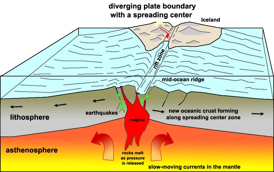 Fig. 5-23. Formation of new oceanic crust along a spreading center associated with a mid-ocean ridge. Some spreading centers appear on land. For example, a portion of the Mid-Atlantic Ridge is exposed as Iceland. |
| What is the difference between a mid-ocean ridge and a mid-ocean rise? The two features are basically the same except for their shape (topography) and how fast they form. Topographic differences are controlled by spreading rates • Ridges are steeper with slow spreading rates (1-5 centimeters per year) - Example: Mid-Atlantic Ridge • Rises are flatter with fast spreading rates (greater than 9 centimeters per year) - Example: East Pacific Rise Why are ridges and rises so high? • Newly created oceanic lithosphere is hot and occupies more volume (less dense) than cooler older rocks • As the oceanic crust travels away from the ridge crest it cools and becomes more dense and sinks |
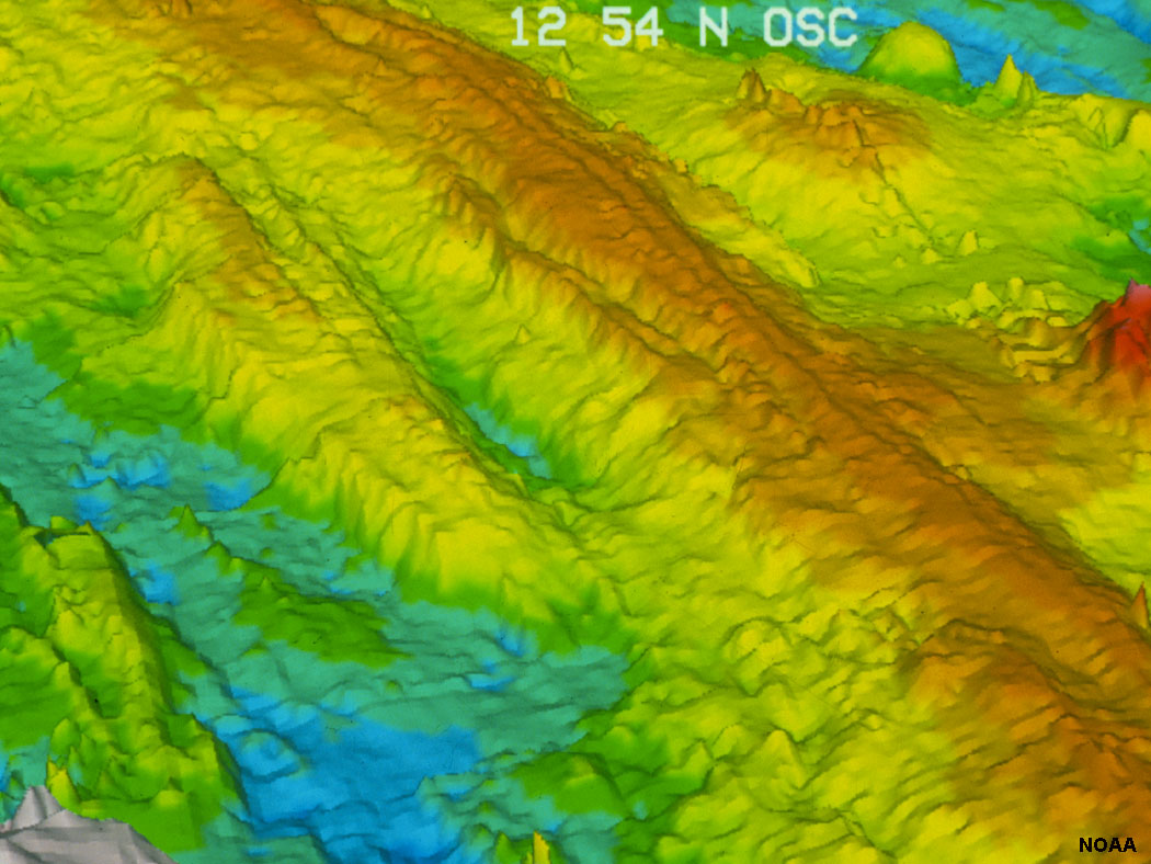 Fig. 5-24. Bathymetric image of the spreading center on the East Pacific Rise. |
Oceanic Lithosphere and BasinsOrigin of oceanic lithosphereAt mid-ocean ridges (spreading centers), lithospheric plates move apart. This creates space for magma to flow upward into the newly created fractures. Over time, more and more fractures form, fill with magma, and then cool and fracture. This process generates new oceanic lithosphere (ocean crust).Zones of active rifting along mid-ocean ridges are typically 12 to 18 miles (20 to 30 km) wide. In some locations, the very hot, fluid lava migrating upward from the asthenosphere (upper mantle) reaches the surface of the seafloor resulting in formation of undersea volcanoes. These undersea eruption produce pillow basalts - pillow-shaped pods of basalt rock formed where the hot lava cools rapidly when exposed to seawater. As new lithosphere forms, it gradually moves away from the mid-ocean ridge crest beyond the zone of active rifting and volcanism. Over time, the cooling crust gets denser and isostatically sinks lower where it is floating on the asthenosphere. Oceanic sediments gradually blanket the aging oceanic crust as it moves away from the spreading center. The layer of sediment grows thicker and thicker as it moves away from the mid-ocean ridge. Structure of the oceanic lithosphere
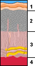
Formation of oceanic lithosphere • Magma (liquid material carrying crystals with it) originates from partially melted mantle forms Layer 4. • Magma injected into fractures above the magma chambers creates the sheeted dike complex, forming Layer 3. • Pillow basalts are from basaltic lava that is flash cooled in seawater, forming Layer 2. • Sediments deposit on top of pillow basalts, forming Layer 1. Aging of oceanic lithosphere results in chemical and physical changes Once new oceanic lithosphere forms it begins to cool. The lithosphere is very warm relative to the cold ocean water above it. Large quantities of seawater sink into the new ocean crust and chemically reacts with it. These chemical process are a form of metamorphism. Ultramafic rock (rocks enriched in magnesium and iron) that formed deep in the upper mantle and oceanic lithosphere can gradually be altered into serpentinite. Large amounts of serpentinite are exposed in the Coast Ranges of northern California where old ocean crust has been pushed up and exposed in the mountain ranges. |
 Fig. 5-25. Formation of an ophiolite sequence (ocean crust) near mid-ocean ridges. 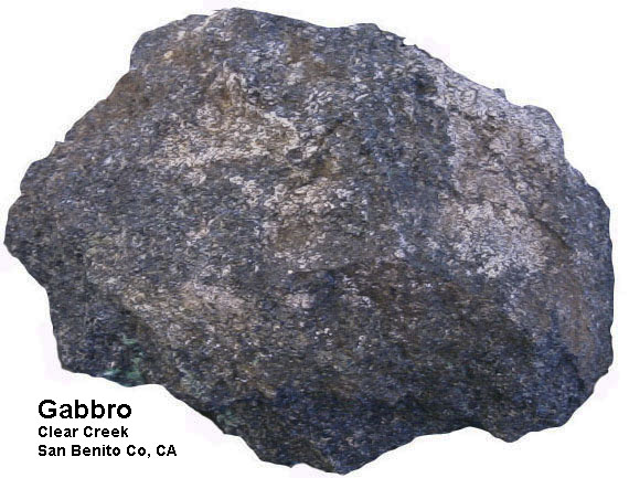 Fig. 5-26. Gabbro, a dominant crystalline igneous rock type formed in oceanic lithosphere.  Fig. 5-27. Pillow basalts exposed near Avila Beach, central California.  Fig. 5-28. Serpentinite (the State Rock of California) is a metamorphic rock derived from altered oceanic lithosphere (mostly Layer 4). This outcrop is part of a large mountain-sized block of oceanic crust exposed in the mountains near San Jose, California. |
|||||||
Formation and Destruction Cycle of Oceanic Lithosphere |
Continental rifting: The birth of a new ocean basin• A new ocean basin begins with a the formation of a continental rift (example: the African Rift valleys, Figure 5-29).• The Red Sea is an example of a rift valley that has lengthened and deepened into a narrow linear sea • If spreading continues the Red Sea will grow wider and develop an oceanic ridge similar to the Atlantic Ocean. Subduction: The destruction of oceanic lithosphere• Oceanic lithosphere subducts because its overall density is greater than the underlying mantle• Subduction of older, colder lithosphere results in STEEP descending angles of the sinking oceanic lithosphere. • Younger, warmer oceanic lithosphere is more buoyant and angles of descent are SHALLOW. • Research indicates that parts, or even entire oceanic basins, have been destroyed along subduction zones. Destruction of oceanic lithosphere adds new material to continental crustAs oceanic lithosphere sinks back into the asthenosphere it carries large quantities of seawater and sediment with it. As it sinks, the increased heat and pressure forces water and gases out of the rock. This combination of trapped water and gases allows some of the material melt. The resulting magma that forms is depleted in iron and magnesium, but enriched in aluminum and silica (felsic in composition). This is because mafic minerals have both higher melting temperatures and higher density than felsic minerals.As a result a natural refining process occurs... mafic material sinks back into the mantle whereas the molten felsic material (along with trapped water and gases) separate and work their way back to the surface. This results in the formation of volcanoes in the region above where subducting lithospheric slabs are sinking. This felsic material is less dense and becomes incorporated into new continental crust. Over long periods of time, enough felsic material accumulates to build continents, a process that may take billions of years. |
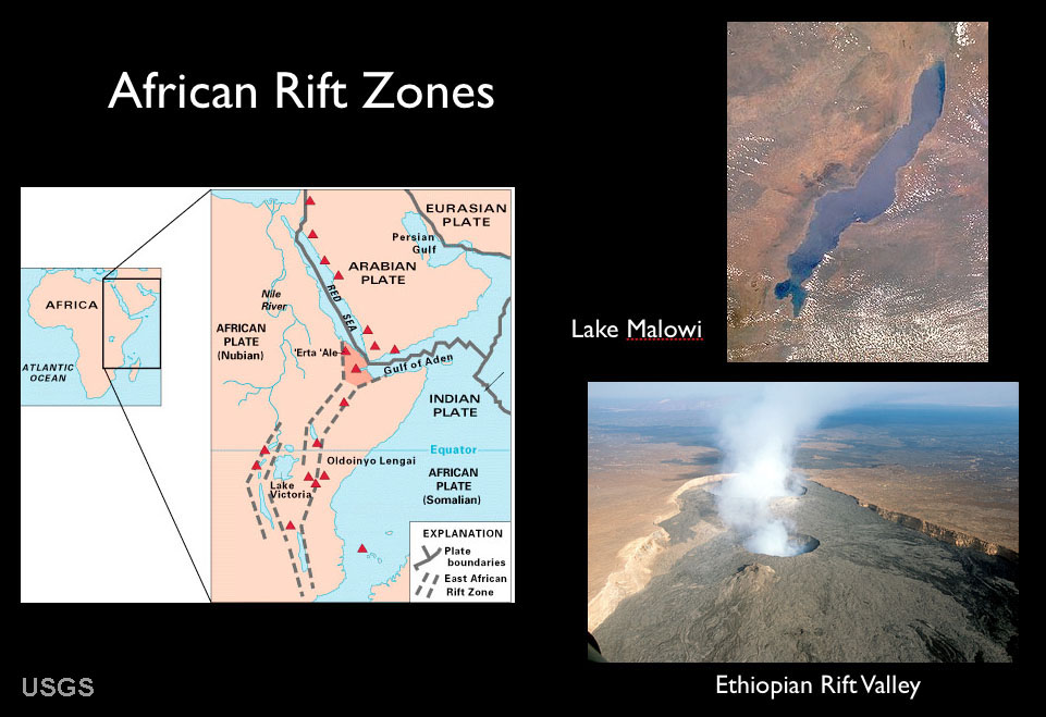 Fig. 5-29. Map and features associated with African continental rift zones. 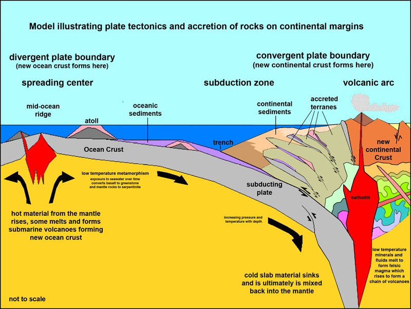 Fig. 5-30. A plate tectonics model illustrating the formation and destruction of oceanic crust and the formation of continental crust. Fig. 5-30. A plate tectonics model illustrating the formation and destruction of oceanic crust and the formation of continental crust. |
|
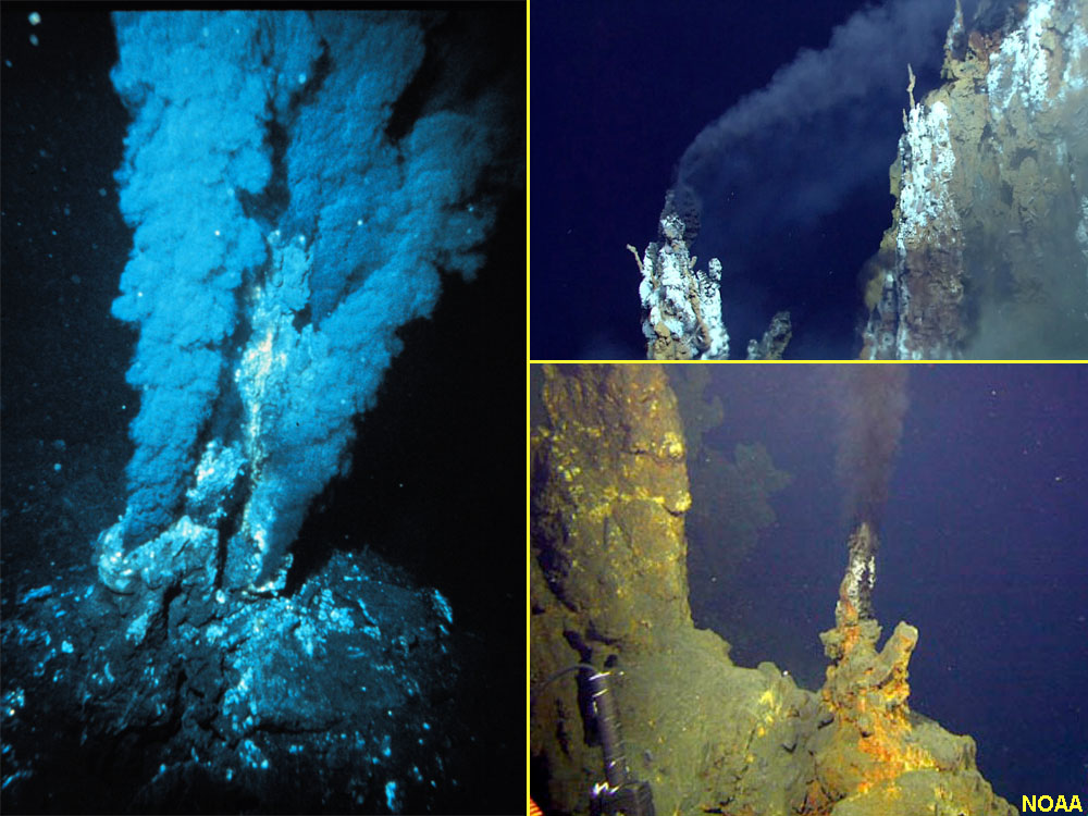
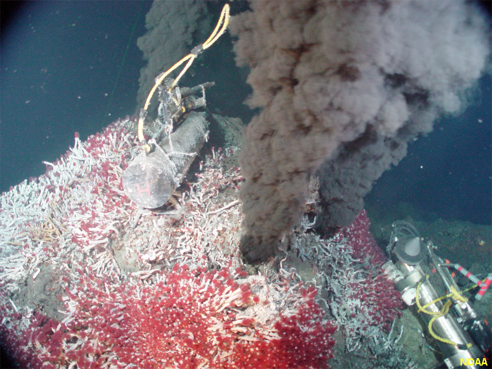
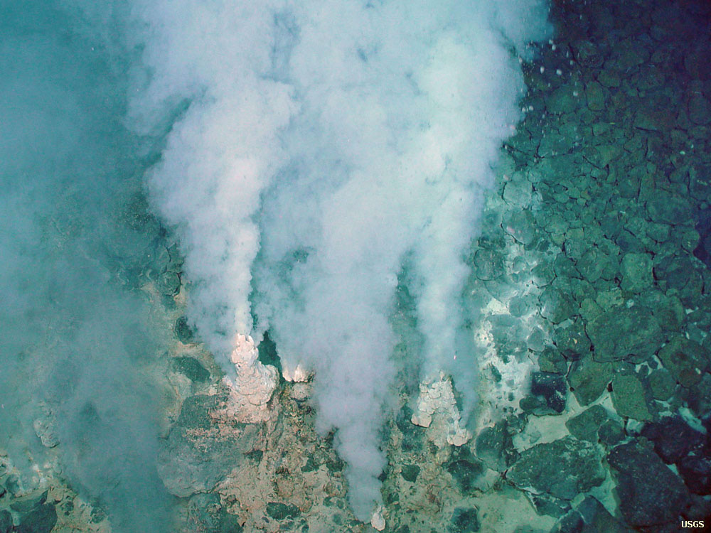
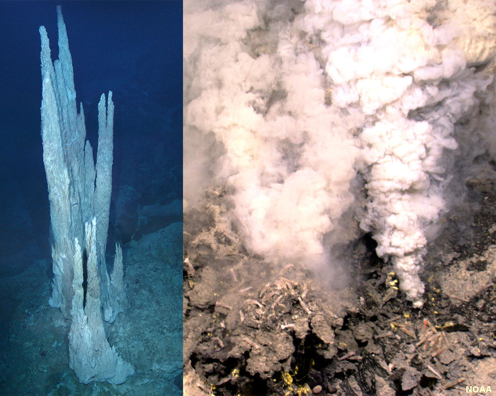
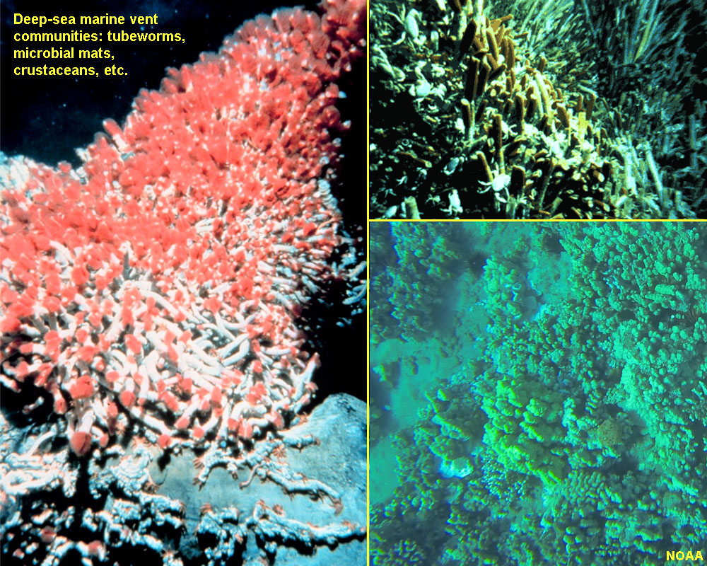
Vents on the Seafloor: Black Smokers, White Smokers, and Deep-Sea Vent Communities |
||||||||||||||||
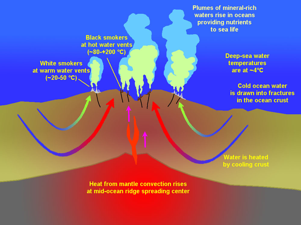
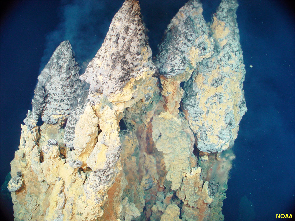
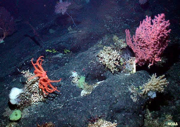
Hydrothermal vents form where there is volcanic activity on or below the ocean floor, such as along the Mid-Ocean Ridge. Water seeps through cracks in the seafloor and is heated by hot rock deep below the ocean crust to as high as 400°C. This hot water is under too much pressure to boil, but it erupts as “smoky fountains” at vents on the sea floor. The hottest vent produce unusual chimney-like towers called "black smokers." The hot water contains dissolved metals (including iron, manganese, zinc, copper, sulfur, and others). When they encounter the cold ocean water, the minerals precipitate, making dark plumes of water and irregular deposits (including “chimneys”) on the seabed. The rich supply of nutrients support chemotrophic bacteria (feeding on sulfur compounds) that support a complete food web of seafloor creatures, including tube worms, arthropods, fish, and other benthic life forms adapted to these harsh and temporary environments. Cooler vents produce “white smokers” that are dominated by deposits of calcium-rich minerals, including anhydrite gypsum (CaSO4) and calcite (CaCO3). Minerals in ocean crustal rocks are rich in calcium, which dissolves easily on cold seawater. Where the warmed seawater rises back to the surface, the calcium-enriched water produces “white smokers” along with deposits of minerals that also host deep-sea bed communities. Deep sea vents have been identified in many locations along mid-ocean ridges and along the flanks of undersea volcanoes. Current thought is that many of the major economic mineral deposits of the world may be associated with ancient deep-sea vent deposits. |
||||||||||||||||
|
Coastal Plains, Climate Change, and Predicted Sea-Level Rise |
||
Climate change is a theory that has growing significance as overwhelming evidence shows that observable changes have been and are occurring in the atmosphere and oceans. Several factors are responsible. First, the natural cycles of continental glaciation associated with cyclic changes in the amount of solar energy the polar regions the Earth receives (ice ages are discussed in more detail in Chapter 9). The second factor is the modern impact of greenhouse gases on global warming created in the modern era of industrialization.Impact of Melting Glaciers On Sea-Level RiseGlobal warming has been taking place since the end of the last ice age, and the impact of sea level rise caused the melting of the massive continental glaciers is easily observable (this is discussed more detail in following chapters). The peak of the natural part of latest global warming cycle may have happened nearly 7,600 years ago, as warming of the atmosphere and the associated sea level rise drastically slowed down at about that time. The peak of the last ice age, about 26,500 years ago when massive continental ice sheets, ice caps, and alpine glaciers cover much of northern Europe and North America, more extensive glaciers in Antarctica (Figure 5-39). This displaced nearly 10 million cubic miles of ocean water onto the land to be stored as ice. Research shows that onset of deglaciation began about 20,000 years ago in the Northern Hemisphere with a massive rise in sea level starting starting about 14-15,000 years ago with deglaciation of the West Antarctic Ice Sheet. The location of shelf breaks around the world shows that sea level has risen about 400 feet (120 meters) since the peak of the last ice age.The effects of sea-level rise is very obvious on the landscape. Perhaps most obvious are that coastal river valley are now submerged in seawater in most locations around the world. If example, Chesapeake Bay and Delaware Bays were a river valleys about 400 feet deep at the peak of the last ice age; it is now submerged as salt-water estuaries (Figure 5-40). Global Warming and Sea Level Rise have happened many times in the geologic past.Figure 5-41 shows a map of the Fall Line. The map also shows the location of Fall-Line Cities along the inland margin of the Atlantic and Gulf coastal plains). The Fall line is an imaginary line, marked by waterfalls and rapids, where rivers descend abruptly from an upland to a lowland. Historically, it is the location that major cities became established because it was the farthest point up a river ships could travel before they encountered rapids, waterfalls, or conditions too shallow for ships to continue farther inland. In the Eastern U.S. the imaginary fall line is between the Appalachian Piedmont and the Atlantic coastal plain physiographic provinces. Similar fall lines can be observed along coastal plains in locations around the world. In the United States, the Fall Line boundary roughly follows an elevation of about 60 meters (200 feet) above sea level, This elevation is what sea level was before glacial ice started forming on Antarctica and Greenland when the Earth was ice free about 35 million years ago. At that time, the entire Atlantic and Gulf Coastal Plains were submerged and were part of the continental shelf. Since then sea level has risen and fallen many times as continental glaciers have formed and melted. Sea level is now rising again, but cause of that increased rate is what is the problem.The Great Problem of Our Times: Accumulation of Greenhouse Gases In The AtmosphereThe demand for energy and agricultural resources by the world's expanding human population began to increase significantly since the beginning of the Industrial Revolution in the mid 1900s. Awareness of the environmental impact of this consumption began to become obvious most obvious when air pollution levels first began to intolerable in large urban regions around the world beginning in the 1960 (on into the present). With satellite technologies and collaborative international action in gathering of atmospheric and oceanographic data the Scientific Community is gathering and presenting evidence of active changes taking place around the world. These changes are caused by the introduction of vast quantities of greenhouse gases from the burning of fossil fuels (coal, oil, gas) and from deforestation and poor agricultural practices (soil destruction and livestock). The world's Scientific Community almost unanimously agrees that the effects of climate change are very real. Projections are being made about the plausible impacts climate change is going to have on the destruction of ecosystems, the rise in sea level.The environmental impacts of climate change associated with greenhouse gas emissions are monumental. Here is a partial list: • A summary of scientific research presented in 2013 by the United Nations' Intergovernmental Panel on Climate Change (summarized by by the Washington Post in 2016) suggests that sea level rise is estimated to rise between 0.52 and 0.98 meters (1.7 and 3.22 feet) by the year 2100, with other estimates ranging higher. This report also suggest that melting of ice on Antarctica alone could cause seas to rise more than 15 meters (49 feet) by 2500. • Global temperatures have risen by 1.5° Celsius since the pre-Industrial Era began, and this increase is projected to continue with the most significant rise happening in the past 20 years on an annual basis. A 2° Celsius rise alone is projected to have catastrophic impacts on ecosystems around the world. Warm-climate species will expand their ranges to the detriment of cold-climate species on all levels on of the world's food chains (oceanic and terrestrial). Estimate reported by the Natural Resources Defense Council suggest that global warming may cause the global temperature by as much at 8° Celsius by 2100 if the projected consumption of fossil fuels and other releases of greenhouse gases continues unmitigated. • Global distribution of rain fall is expected to change, and major tropical storms are expected to increase in intensity. • Increased level of CO2 in the air is increasing the acidity of ocean surface waters, negatively impacting many species. • Arctic regions are particularly experiencing climate change impacts involving the gradual disappearance of sea ice, the melting of permafrost, and the rapidly increasing rate of melting of glaciers. Examples: The effects of sea-level rise are quite obvious in Louisiana (where the land is sinking and eroding, Figure 5-42). Figure 5-43 shows how the Gulf and Atlantic coastal regions will change with a rise of 1, 2, 3, and 4 meters. Figure 5-44 shows the 4 meter water line in Washington DC. It will be interesting to see how the political world will deal with these changes! The political and economic consequences caused by inaction to stop potential calamities caused by climate change are staggering to ponder. The world faces economic crisis driven, in part, by the conflicting greed by international carbon-gas-producing industries, and largely by the increasing demand for energy and natural resources by individuals to entire nations that are unable or unwilling to accept their share of responsibility.
|
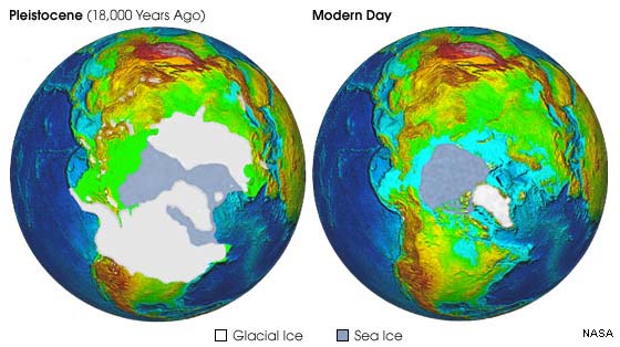 Fig. 5-39. Extent of glaciers and sea ice during the peak of the last ice age and today in the Northern Hemisphere. 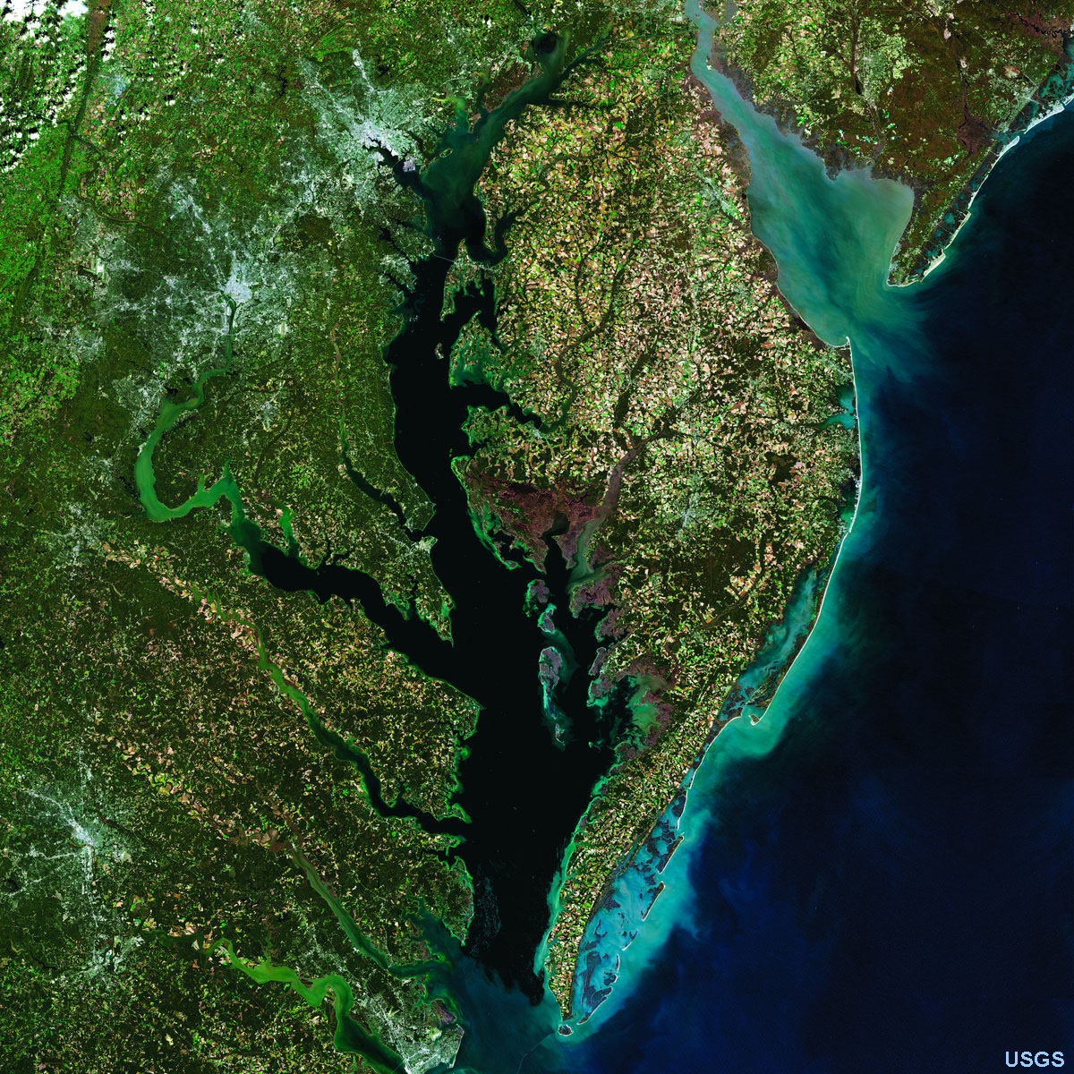 Fig. 5-40. Chesapeake and Delaware Bays (estuaries), and the Delmarva Peninsula. Sea-level rise has back filled river valleys draining into the Atlantic Ocean. Ridges on land became peninsulas. 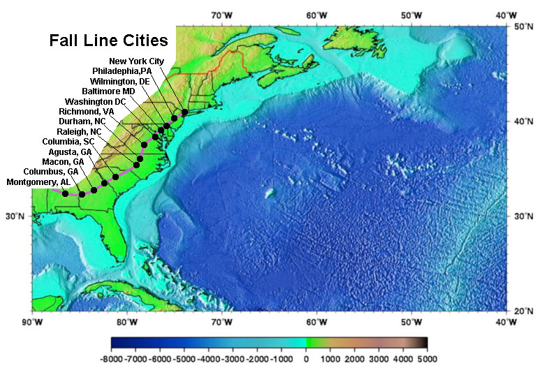 Fig. 5-41. Fall line cities on along the inland margin of the Atlantic and Gulf coastal plains.  Fig. 5-42. 50 years of land loss from sea level change and coastal erosion in Louisiana. 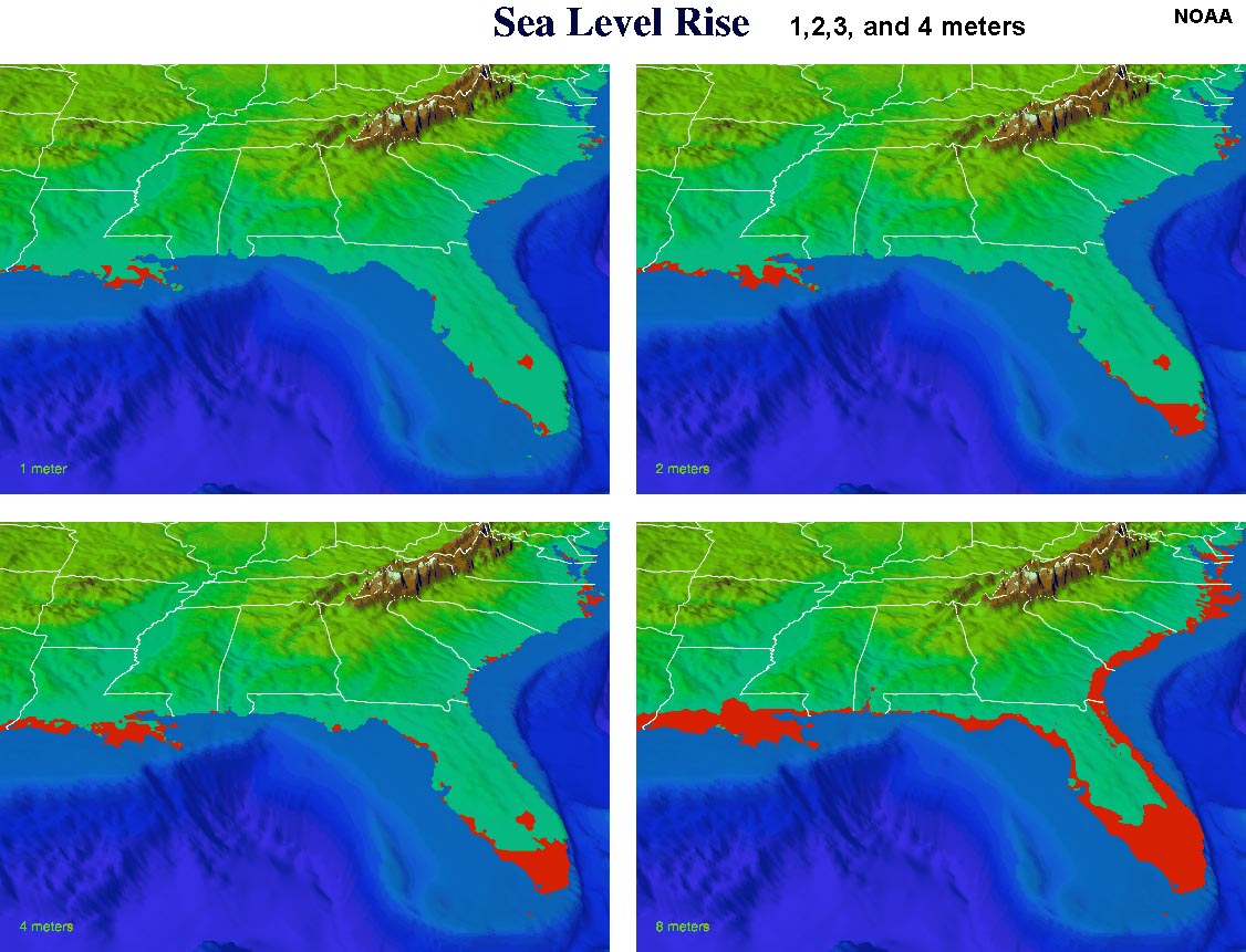 Fig. 5-43. Projected changes from 1,2,3, & 4 meters of sea-level rise on the East Coast. 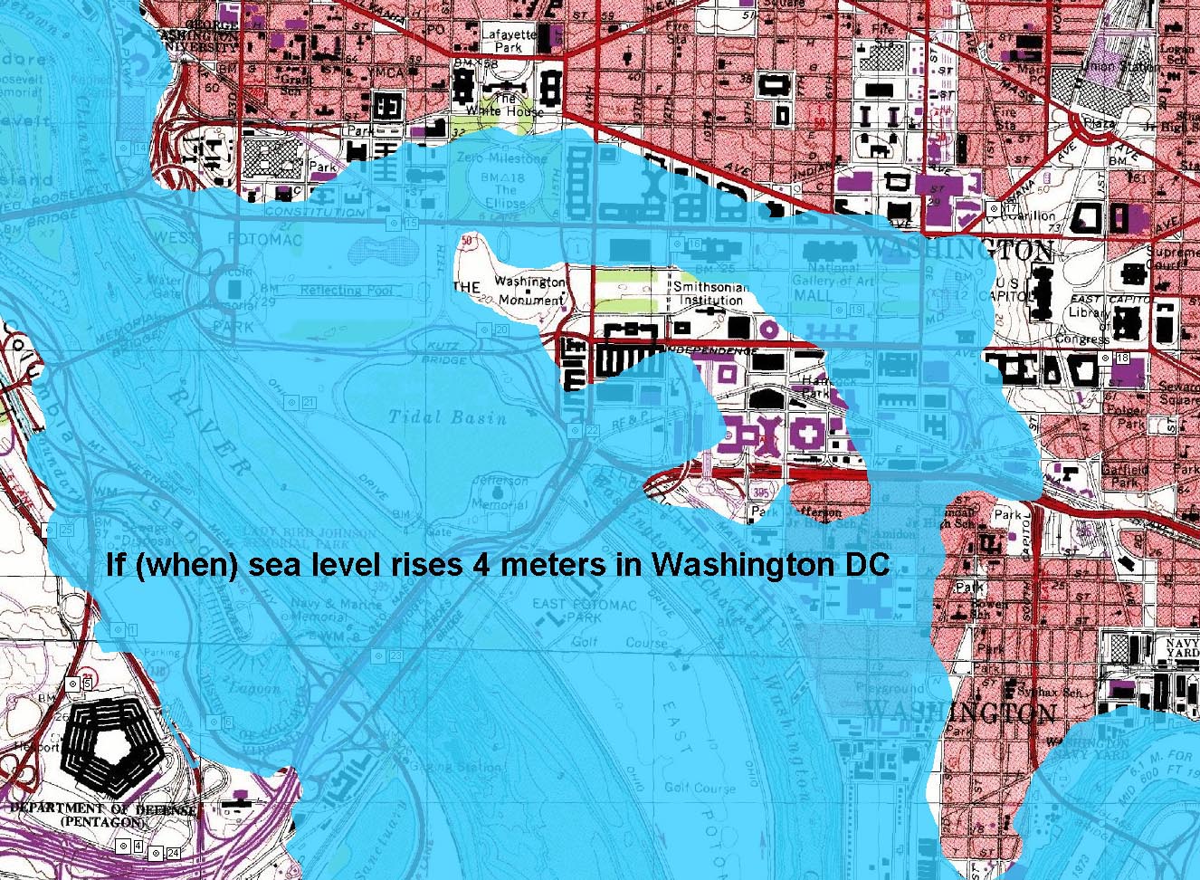 Fig. 5-43. Projected flood zone of Washington DC if sea level rises 4 meters. Congress will have to paddle canoes to get to the White House! |
|
Selected ResourcesGalapagos Regional Geology (NOAA) - The Galapagos Islands are an island chain on a spreading center in the Pacific Ocean basin.Hawaii Lava Lake video (USGS) - This view of the fractures changing on the crust on a lava lake in Hawaii's Kilauea Volcano is a good proxy for the formation of spreading centers (on a smaller scale). |
| Chapter 5 Quiz Questions | |
https://gotbooks.miracosta.edu/oceans/chapter5.html |
1/1/2018 |