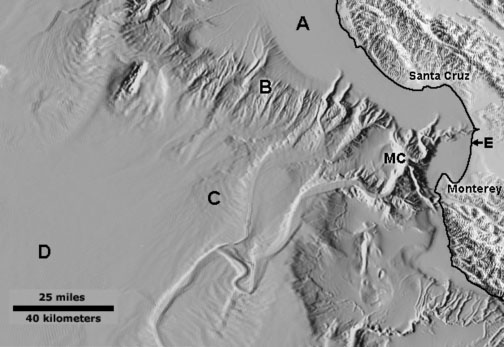
Questions 1 to 6 refer to the image below that shows a map of the coastline and the seafloor in a region including Monterey Bay—located between the coastal cities of Monterey and Santa Cruz and Monterey Canyon (shown as MC). On the image, the arrow for letter E points to the coastline along Monterey Bay.
1. On the seafloor, Letter A is located on:
a. continental rise.
b. continental shelf.
c. continental slope.
d. abyssal plain.
2. On the seafloor, Letter B is located on:
a. continental rise
b. continental shelf
c. continental slope
d. abyssal plane
3. On the seafloor, Letter C is located on the:
a. continental rise
b. continental shelf
c. continental slope
d. abyssal plane
4. An extensive flat section of the seafloor, Letter D is located on the:
a. continental rise.
b. continental shelf.
c. continental slope.
d. abyssal plain.
5. The “shelf break” is located:
a. between letters A and B.
b. between letters B and C.
c. between letters C and D.
d. at letter E
6. Monterey Canyon (shown as letters “MC”) is about twice the size of the Grand Canyon in Arizona. Submarine landslides and turbidity currents move sediments down submarine canyons to be deposited mostly on the:
a. continental rise
b. continental shelf.
c. continental slope.
d. abyssal plain.
7. An example of a passive margin is:
a. the coast of California, Oregon, and Washington.
b. the coast of southern Alaska.
c. the East Coast of the United States.
d. Hawaii.
8. Which of the following is NOT true about ocean trenches?
a. They are long, relatively narrow canyon-like features that run parallel to continental margins.
b. They are the deepest parts of ocean basins.
c.
They usually occur in the ocean along volcanic island chains.
d. None of the above.
9. An ancient submarine volcano that has a flat top (beveled by wave action before sinking into ocean depths) and may lack fringing reefs is called:
a. an atoll.
b. a seamount.
c. a guyot.
d. a mid-ocean ridge.
10. The shallowest and youngest parts of deep, central ocean basins are typically:
a. mid-ocean ridges.
b. abyssal plains.
c. volcanic island arcs.
d. trenches.
11. As new ocean crust forms along mid-ocean ridges, what happens to the older ocean crust?
a. Older crust moves away from spreading centers.
b. The
older ocean crust cools and sinks deeper into the ocean basins.
c. The ocean crust is blanketed with layers of ocean sediments.
d. Old, cold ocean crust eventually sinks into subduction zones.
e. all of the above.
12. Pillow basalts occur where:
a. sediments accumulate in beds on the seafloor.
b. lava erupts and cools quickly on the seafloor on submarine volcanoes, such as along mid-ocean ridges.
c. lava erupts from a volcano on an island arc chain.
d. fringing reefs form around an ancient volcano.
13. Serpentinite is the State Rock of California. It occurs in abundance throughout the coast ranges of Northern California. Serpentinite is a rock formed from:
a. the accumulation of the remains of ancient sea snakes.
b. a rock formed by the metamorphic alteration of ocean crustal rocks (basalt and gabbro) by exposure to seawater
seeping into the ocean crust over time.
c. a rock formed from the accumulation of undersea landslide deposits.
d. all of the above.
14. As old ocean crust is destroyed in subduction zones, new continental crust forms as a result of:
a. water and gases released by increasing heat and pressure helps to melt some of the old ocean crust.
b. lighter, low temperature "felsic" minerals melt first
and migrate upward, forming volcanoes and new continental crust.
c. denser, high temperature "mafic" minerals are concentrated in the old ocean crust that sinks back into the mantle.
d. all of the above.
15. Black smokers and white smokers are features are:
a. hydrothermal vents associated with volcanic activity on the seafloor.
b. most common along the rift zones associated with mid-ocean ridges.
c.
host to biological communities that are supported by chemotrophic bacteria.
d. all of the above.
16. What is true about the relationship of coastal plains and continental shelves?
a.
Coastal plains were part of the continental shelves that have been exposed by the fall of sea level.
b. Continental shelves are submerged portions of coastal plains that were exposed during the peaks of the ice ages.
c. The shelf breaks around the world roughly mark the locations of shoreline of the coastal plains at the
peak of the last ice age.
d. All the choices are correct.
17. About 35 million years ago was the last time that Antarctica was ice free. Since then sea level has fallen and risen many times as continental glaciers advanced and retreated. During the peak of the high seas, the continental shelves extended inland, covering the coastal plains around the world. In North America, the hypothetical boundary between the Atlantic and Gulf coastal plains and upland regions is called:
a. the Fall Line.
b. the shelf break.
c. the Piedmont.
d. the continental rise.
18. According to a 2013 report by the United Nations Intergovernmental Panel on Climate Change, how much is sea level anticipated to rise by the year 2100?
a. Sea level is not changing.
b.
Sea level is estimated to rise between 0.52 and 0.98 meters (1.7 and 3.22 feet).
c. Sea level is estimated to rise about 4 meters (13 feet).
d. Sea level is estimated to rise more than 15 meters (49 feet).
19. According to a Natural Resource Defense Council report (2017), how much will global temperatures rise by the year 2100 if current projections of fossil fuel consumption and other effects releasing greenhouse gases continues unmitigated?
a. Global temperatures will go down.
b. Global temperatures will not change.
c. Global temperatures could rise 2° Celsius.
d.
Global temperatures could rise 8° Celsius.
20. According the Natural Resource Defense Council report (2017), What are some of the anticipated impacts if climate change effects from global warming continue unmitigated?
a. Global distribution of rain fall is expected to change, and major tropical storms are expected to increase in intensity.
b. Increased level of CO2 in the air is increasing the acidity of ocean surface waters, negatively impacting many species.
c. Arctic regions are particularly experiencing climate change impacts involving the gradual disappearance of sea ice, the melting of permafrost, and the rapidly increasing rate of melting of glaciers.
d.
All of the above.
|
