Quaternary Lakes and River Systems
Prior to the Ice Ages most rivers in the midcontinent region drained northward into Hudson Bay. The advancement of glaciers southward blocked, ponded, and diverted river systems. These processes significantly increased the watershed of the modern rivers south of ice sheet, and during times of rapid melting water flows must have been very great. Mounting evidence suggests that "breakouts" caused by ice-dammed rivers frequently breached ice and moraine dams, and caused massive floods that episodically annihilated ecosystems along the mouths of rivers. Such events probably occurred along the drainages of the Hudson and the Delaware. Schuberth (1968) suggested that prior to the Pleistocene Epoch the ancient Hudson River flowed southward across the coastal plain via the Newark Basin west of the Palisades, snaking through water gaps in the Watchung Mountains in New Jersey. This ancestral river turned eastward south of Staten Island and continued across what is now Raritan Bay before turning southward again near Sandy Hook. North of New York City, the Hudson followed a path along fault zones through the Highlands region. Farther north, the wide Hudson River Lowland (east of the Catskills) is a vestige of the broad flood plain associated with the ancestral Hudson River. However, the glaciers of the Quaternary changed everything!
The evidence for a terminal moraine across the Narrows of New York Harbor suggests that the river outlet was completely blocked (or even non-existent for a time under the ice) during the climax of the Wisconsin glacier. Water draining from the ice sheet during melting periods carved or modified the valleys of Arthur Kill, and the Raritan and Passaic Rivers. River channels were block by ice, diverting the drainages southward in advance of the ice sheets. For a time water from the Hudson was diverted across central New Jersey, flowing into the Delaware River in the vicinity of Trenton.When ice blocked the narrows, the Hudson followed yet another course southward around Staten Island in the valley now occupied by the Arthur Kill.
A buried channel of the ancestral Hudson River flowed south approximately 50 miles on the then-exposed continental shelf. This buried channel ranges in width between 1.5 to 10 miles, and was carved into a subaerially exposed surface prior to 28,000 years ago. It is covered by as much as 30 to 100 feet of younger sediments deposited during the late Wisconsin-Holocene transgression (Stage 1). During each of the glacial advances the Hudson River (and its tributaries) deeply cut into its flood plain carving valleys that extended to the edge of the continental shelf and beyond. In the offshore region submarine erosion processes cut deep canyons into the outer margin of the continental shelf and slope, and sediment was deposited on deep water fans in the Baltimore Canyon Trough region which gradually built upward and eastward onto the distant abyssal plain.
Although most of the old Pleistocene Hudson River valley is filled with modern sediments, the continental shelf passageway is still evident on bathymetric charts. After leaving the central Outer Harbor the channel bends southeastward; it continues in that general direction until it descends into deep water as the Hudson Canyon at the continental shelf margin. Several smaller submarine canyons are probably related to this geologic episode. They exist far offshore from the central New Jersey coast, roughly about 80 miles east of Barnegat Inlet. During high-standing seas the valleys were flooded, allowing marine, estuarine, and riverine sediments to fill in the submerged valleys on the shelf.
This was perhaps the largest of several moraine-dammed lakes that existed briefly in the region at the close of the Pleistocene (Figure 144). Shortly after the Wisconsin glacier began to retreat, this lake covered most of the lowlands of northern New Jersey. At its peak the lake was as much as 150 to 200 feet. (The Great Swamp National Wildlife Refuge - our nation's first - in Morris and Somerset Counties, New Jersey, is a very small remnant of Glacial Lake Passaic). Other lakes formed throughout the region caused by stream blockages by ice and by moraine dams. Lakes also formed in valleys of the Hackensack, Hudson, and East Rivers. (Manhattan Island was partially submerged under Glacial Lake Flushing.) These lakes were short lived as erosion quickly carved passages through the poorly consolidated moraine dams. However, evidence for these lakes is preserved in the form of varved sediments. These are lake deposits that feature alternating seasonal bands of organic-rich (summer) and organic poor (winter) mud.
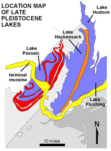 |
| Figure 144. Map showing the location of the terminal moraine of the Wisconsin glacier (Stage 2) and the extent of moraine-dammed lakes in the New York City area (after Schubert, 1967). The red are the ridges of the Watchung Mountains; the orange is the Palisades; yellow is the upland created by the terminal moraine. Note that the modern shoreline configuration (shown in gray) did not exist yet because sea level was much lower. The Raritan River system developed along the southern end of the terminal moraine. |
| Return to Glaciers of the Quaternary page. |