The Flandrian Transgression
The name "Flandrian" has been applied to the current sea level rise affecting the coastal regions around the globe which began approximately 18,000-19,000 years ago (Stage 1 - beginning in latest Pleistocene time and continuing progressively through Holocene to the present). This rise in sea level is directly related to the melting of the Wisconsin (Stage 2) continental polar and mountain piedmont glaciers. However, the rate of melting and proportional sea level rise was not constant through time. Sea level rose quickly during warm periods, but stopped or even temporarily fell during cold periods. The character of regional and global climatic patterns are exceedingly complex. For instance, glaciers may be melting in one region while advancing in others, yet the overall global temperature pattern seems to follow insolation variations related to Milankovitch Cycles.
Paleoclimate studies of Stage 1 (the post-glacial period) indicate that global temperatures have varied considerably. It is inferred that the glaciers began to melt quickly following the maximum glacial advance about 17,000-18,000 years before present (BP). Global warming ended the most recent Ice Age in the mid-latitude regions beginning around 14,000 years BP. A brief warm period, called the Allerod occurred roughly 11,500 years BP; this was followed by an cooling trend when glaciers began to readvance. This period called the Younger Dryas lasted from about from about 11,000 to about 9,000 years BP. The Earth then became drastically warmer. The period between about 8,000 to 7,000 years B.P. is called the Hypisthermal (or Altithermal or Climatic Optimum). This time represents the warmest period within the Holocene when global temperatures may have been as much as 4 C higher than today. During that time Africa was much wetter, and the midwestern United States experienced desert-like conditions. Since then, global temperatures have fallen haltingly. A minor warm period called the Little Climatic Optimum began about 300 B.C. and lasted for roughly 1,500 years. A cooling trend called the Little Ice Age began in the 1300s (A.D.) and ended in the 1840s. Earth has been growing progressively warmer since then (rallying concern about global warming). However, using the patterns of previous interglacial stages and predictions based on Milankovitch Cycles, the Earth should be proceeding toward another ice age after the Climatic Optimum that occurred during the Hypisthermal (about 7,500 years BP). It is somewhat ironic that our contribution of greenhouse gases to the atmosphere may actually be helping to delay the next ice age from starting!
As stated above, the changing pattern of global temperatures had an effect on the rate of sea level rise during the Flandrian transgression. Sea level may have advanced and fallen haltingly, with an overall trend toward rising to its current level. During the climax of the Wisconsin glacial advance (about 18,000 years ago) sea level was anywhere between 70 to 150 meters below its current level (depending on whose interpretation you choose). Most researchers agree that the lowest sea level corresponds to a location near the "break in slope" at the outer edge of the continental shelf. The shelf break occurs at approximately 100 meters below current sea level on tectonically stable continental shelves around the world.
However, the setting of ancient coastlines in the New York Bight region is slightly more complex. The history of this sea level rise is difficult to decipher for a variety of reasons. Finding ancient sea levels must include consideration of regional and local subsidence, sediment compaction, tectonic movement, and isostatic adjustment due to variation in load by ice, water, and sediment. With all of these factors considered, practically no two beaches in the region have the same geologic history. The weight of the glaciers alone had a significant impact on regional sea level. As the glaciers formed, the weight of many thousands of feet of ice forced the Earth's crust to compress and gradually sink into the mantle (in the same manner that a ship sinks deeper into the water as it is loaded with cargo). Likewise, when the ice melts, the crust readjusts upward again. This process is called isostatic rebound. Today, the greatest amount of isostatic rebound is occurring in the region around Hudson Bay where the Laurentide Ice Sheet was thickest. Estimates suggest that the land in that vicinity has rebounded 250 meters or more since the Wisconsin glacier melted. The amount of rebound in and around the New York Bight is perhaps more on the order of 50 meters, with diminishing effects farther to the south. The amount of rebound is directly proportional to the thickness of ice. The center of the ice sheet that fed the advancing ice front in the New York Bight was located in the Labrador Sector east of Hudson Bay. Another smaller center probably accumulated over the Adirondack region of northern New York. Using modern Greenland as a model, the Laurentide ice sheet was probably as great as 5 kilometers thick. Maps and geophysical studies of Greenland Ice Sheet show that although the margins of this small continent are lined with mountains many thousands of feet high, the bedrock at the center of the Greenland has been depressed by the weight of the ice to many hundreds of feet below sea level. On North America as the glaciers advanced southward, the crust behaved much in the manner as when a person sits on an air mattress in a pool; the mattress sinks beneath weight of the human and springs up around the edges. When the raft is abandoned, it readjusts back to an undeformed profile.
Figure 145 illustrates the probable landscape changes of the New York Bight during and following the last glacial advance. The crust sank beneath and around the weight of the glacier, but rose as a "fore-bulge" in regions many tens to hundreds of miles away from the advancing ice front (Figure 145A-B). The combined effect of sea-level fall and fore-bulge uplift during the advance of Pleistocene glaciers probably exposed portions of the continental shelf to erosion. When the ice melted, the depressed regions inshore may have experienced marine transgression before areas farther offshore (Figure 145 C). It is important to note that the process of crustal isostatic adjustment (sinking and rebound) is much slower than the rate of ice accumulation and melting. These two factors add to the complexity of interpreting marine transgressions and regressions in the regions around ice sheets. As glaciers formed, sea level dropped at a much faster rate than isostatic subsidence caused by the buildup of ice. During the following Flandrian transgression, sea level rise was very rapid early in the Late Pleistocene, but the rate of sea level rise has slowed drastically during the progress of the Holocene. As a result of this slow down, marine coastal processes allowed barrier islands to develop; there barriers have migrated slowly landward with the rise in sea level (Figure 145D-E). However, during the period when sea level was lower in the New York Bight, the ancestral Hudson, Raritan, Hackensack, Passaic, Navesink, and Shrewsbury Rivers probably merged to created one large and transient, storm- and tidal-dominated delta complex in the region seaward of the current Outer New York Harbor region (Figure 146).
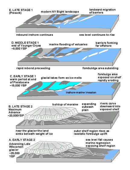 |
| Figure 145. Reconstruction of changes in the landscape in the New York City region from 25,000 years ago to the present. |
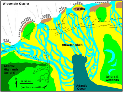 |
| Figure 146. Hypothetical map of the New York City region during the maximum advance of the late Wisconsin glacier (Stage 2 - about 20,000 years BP). |
The weight of the glacier had depressed the region beneath and near the to a lower level. Even though sea level may have fallen by as much as a 100 meters during the climax of glaciation, in the New York Bight this relative drop in sea level would have been much less. When the ice melted, sea level rose faster than the rate of glacial rebound, and a marine transgression occurred in the inshore region near the terminal moraines. This resulted the formation of the Gardeners Clay, a very late Pleistocene to early Holocene fossiliferous clay and marl unit known to underlie portions of Long Island and Sandy Hook. Fossils indicate that the Gardeners clay was most likely an marine estuary or bay environment (Figures 147). Additional support for this interpretation of an inshore marine transgression comes from the study of sediments from the Hudson River in the vicinity of the Tappan Zee Bridge. Fossils from sediment cores suggest that around the Hudson River valley became a marine estuary around 11,500 years BP. The maximum marine transgression into the Hudson River Valley occurred about 6,500 years B.P. Since then, the salinity of the estuary has dropped its current brackish condition (see Weiss, D., 1974).
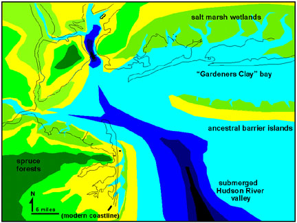 |
| Figure 147. Hypothetical map of the New York City during deposition of the Gardeners Clay in early Holocene time (Stage 1 - about 8,000 year BP). |
During the cooler Younger Dryas, the rate of glacier melting halted or even reversed. However, by this time the ice sheet was greatly diminished and had retreated (melted back) far to the north. In the New York Bight, glacial rebound gradually out-paced the rate of sea level rise. This resulted in the end of marine deposition of the Gardeners Clay about 7,000 years BP. Farther seaward, the opposite occurred as relative sea level remained relatively stationary, then began to rise rapidly. Bathymetry studies suggest that a stable shoreline developed far offshore from its present location during the Younger Dryas. This has been suggested by studies of the variations in the topography and sediments on the continental shelf; it appears that sea level remained stationary near the present 60 meter isobath between 12,000 and 9,000 years BP. This ancient strand is known to fisherman as the "Fortune Shore" which exists along the outer continental shelf in the New York Bight (probably named for a fortune in fish and sunken ships!) (see Knebel et al., 1979). However, the accumulation of barrier islands along this ancient strand line may be more of a reflection of an increased sand supply during this period than a stationary sea level. A 30 kilometer wide band of sand ridges on the middle continental shelf offshore from the Atlantic City area represent a degraded and submerged barrier islands that formed between 14,000 and 8,000 years before present (see Stubblefield et al., 1983). Shelf currents are actively reworking the barrier sands into ridges: during winter nor'easter storms, currents scour the topographic lows and deposit the sand on the ridge crests. The reverse process occurs in the summer. (Boulder- sized chunks of well cemented beach sand, displaying bioturbation and marine fossils, are eroding from these submerged barriers, occasionally washing ashore. [see next page "fossils"]) Sometimes these concretions contain root materials, usually bacteria-resistant cedar wood.
Studies in the Gulf Coast region and elsewhere suggest that the rate of sea level rise slowed drastically about 4000 years ago when sea level was about five meters below its current level. It has been in the last 4000 years that the majority of modern coastal barrier islands and tidal wetlands have developed (see Friedman et al., 1992). In the coastal regions where unconsolidated glacial material, outwash, and strandline deposits exist, the process of coastal erosion is more significant than the opposing glacial rebound. In this manner the shoreline has migrated landward at a rate of roughly one kilometer per century (discussed in greater detail in the next chapter)! On the other hand, the processes of rebound probably account for the high coastal elevations of Staten Island, the Atlantic Highlands, and Manhattan. If this is true, then perhaps beyond the coastal areas, a global rise in sea level may be less significant for New York City's future.
Humans likely migrated into the region as the glaciers retreated. They inhabited the landscape at the same time when both fauna and flora advanced their ranges northward into the ice-free areas. (The romantic notion that "old growth" or "virgin forests" existed before Europeans arrived on the continent isn't completely true; modern ecosystems in the New York Bight region evolved along with an endemic human population.) The timing of the first migration of humans into North America is still under debate. But, the timing of the first regional "population explosion" was probably concurrent with a warm period before the return to cooler conditions during the Younger Dryas. During the Younger Dryas, both populations of humans and Pleistocene large game animals declined. This resulted in the mass extinction of the majority of large land mammal at the beginning of the Holocene Epoch approximately 10,000-9,000 years BP. The abundance of Folsom- and Clovis-style projectile points scattered throughout North America dating from earliest Holocene time supports this claim. Although projectile points from these cultures have been found in the New York region, there is extremely scant evidence remaining. If these paleo-Indian cultures bear any similarity to modern human cultural fantasies about living near the ocean then, unfortunately, much of their archeological record is lost to the sea.
| Return to Glaciers of the Quaternary page. |