Geology of the New York City Region
This webstite provides and introduction to the regional geology of the Greater New York City region and surrounding region that is within the range of a day trip from the city. Included are discussions of the geologic history and features of the five physiographic provinces in the region and descriptions of 75 different field-trip locations to observe aspects of the regional geology and processes shaping the coastal regions.New York City's Physical Environment
The Greater New York City Metropolitan Area exists because of its unique geography and cultural history; underlying and influencing it all is its geology. The physical environment of New York City and the surrounding region reflects the culmination of geologic processes affecting the North American continental margin for over a billion years! Highlights of this geologic story include the formation and destruction of ancient mountain ranges and seaways created by the shifting and colliding of ancient land masses. Concurrent and subsequent to the formation of mountain ranges were extensive periods of erosion and sedimentation. Most recently, in geologic terms, there were episodes of continental glaciation when ice sheets spread southward from eastern Canada into the area that is now New York City. Much of the modern landscape owes its character to the sculpting forces of glacial ice and the erosion by rivers south of the ice front. Most recently, if not most significantly, are ongoing changes created by the region's rapidly-growing human population!
The New York Bight
A "bight" is a mariner's term for a bend or curve in the shoreline of an open coast. The name, New York Bight, refers to the great expanse of shallow ocean between Long Island (to the north and east) and the New Jersey Coast (to the south and west). Because Long Island trends generally east to west in relation to the mainland of New Jersey, it creates a great right angle in the geometry of the Atlantic coastline. The Hudson River's outer harbor and the Raritan Bay (shown in the image on the cover) constitute only a fraction of the greater New York Bight region. The New York Bight is a small reentrant within a much larger coastal bight, the Mid Atlantic Bight, extending from Cape Hatteras, NC northward to Cape Cod, MA (Figure 1).
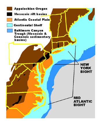 |
| Figure 1. Map of the greater New York City region. The Atlantic shore is a transient line marking the boundary between the ocean and the subaerially exposed coastal plain. The coastal plain actually extends eastward for nearly 70 miles from the shore beneath the shallow waters of the continental shelf. Beyond the eastern shelf margin the submarine surface gradually slopes downward to abyssal depths at an average angle of about 1.3 degrees. At the base of the continental slope water deepens to over 5,000 meters at a distance of roughly 200 miles from the coast. On shore, the flat to gently-rolling topography of the coastal plain extends westward to the "fall line," a natural physiographic demarcation between the "softer" sediments of coastal plain and the "harder" ancient rocks of the Atlantic Piedmont and Appalachian Mountains. This natural barrier is easy to define on a map, even on a political map. During the colonization of America, as ships traveled upstream they eventually encountered rapids where rivers descended from the regions of older, harder rocks. At these points ships were unloaded so villages and cities evolved. Figure 1 illustrates the subdivisions of physiographic provinces assigned to the region. Physiographic provinces are defined by contiguous physical geographic characteristics, such as flat sandy plains, mountainous areas, or rolling hills. The physical setting is attributable to many factors, but most significantly the interaction of the underlying rock with the geologic and surface processes acting on it. The major physiographic subdivisions or provinces addressed within this book include subdivisions of the Appalachian Orogen consisting of: 1) the Highlands Province - the ancient crystalline core of the Appalachian Mountains; and 2) the Valley and Ridge Province - an extensive belt of folded sedimentary rocks extending from the Catskills region southwestward along the trend of the Appalachian Mountains. The Mesozoic Rift Basins include the Newark and Connecticut River Basins in the New York City region. The Atlantic Coastal Plain refers to the subaerially exposed landward extension of the Atlantic Continental Shelf. The continental shelf is transitional with the Baltimore Trough, a deep, thick, submarine sedimentary basin far offshore from the New York Bight area. |
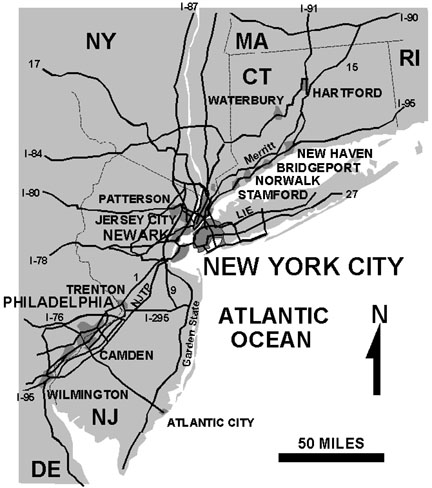 |
Figure 2 is a generalized map showing major urban centers, political boundaries, and the major transportation arteries in the New York City metropolitan region. This map is perhaps the most familiar and useful for our daily life and travel. The natural physical barriers created by the region's coastlines, mountains, and rivers controlled regional development and created incredible technological challenges to be overcome as the population grew. The Manhattan skyline and the region's transportation infrastructure, especially the bridges and tunnels, are a tribute to the power of human endeavors of the 20th Century. |
| Figure 2. major cities and interstate highways in the New York City region. |
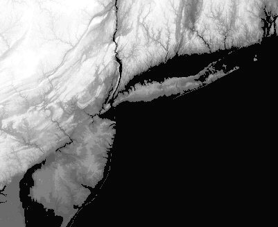 |
| Figure 3. Shaded relief map (digital elevation model) of the New York City region (courtesy of Karen Mulcahy). The regional shaded relief map (Figure 3) was generated from digital elevation data. It represents the general character of the landscape of the area, and is a valuable illustration for the study of the geology of the region for many reasons. [Note that the elevations of the barrier islands along the shore are not significant enough to appear on this 30 meter elevation model.] Landforms, such as rivers, coast lines, hills, plains, and mountains evolve through time by geologic processes such as tectonic uplift, erosion, and sedimentary deposition. The variable resistance of rock materials to the processes of weathering and erosion (by water, glacial ice, or wind) over long periods of time shape the landscape. Geologic maps are essential for unraveling the complex geologic history of the region. Geologic maps show the surficial occurrence of rocks of different ages and compositions, and structural features such as faults and folds that provide information about the character of the sub-surface geology. Link here to examine a general geologic map of the New York City Region. |
Humans: a Geologic Force
To contrast the ongoing processes discussed previously, passage of our generations is an anomalous speck on the end of the geologic time scale. Figure 9 illustrates the human population density in the New York Metropolitan area. This map perhaps best demonstrates how our region is utilized by humans, and expresses the environmental character of our urbanized, coastal culture. Census data reported in the World Almanac for 1998 showed that there were nearly 20 million people in the New York metropolitan area with the population of New York City alone at around 7.3 million.
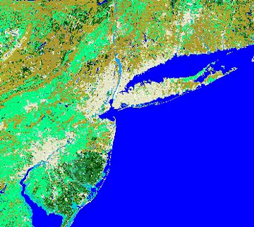 |
Figure 4. Map of landuse/landcover of the New York City region. Light colored areas are urban and suburban areas. Light green represent agricultural areas. Brown represents deciduous forest (undeveloped watersheds) and pine forests. Dark green areas are lands covered with pine forests. Light blue represents wetlands (courtesy of Karen Mulcahy). |
In contrast, when New Amsterdam became established in 1653 the transplanted European population was about 800 whereas the American Indian population was about 14,000. The ballooning population is the driving force behind environmental change. The most obvious changes we can directly observe are the cluttering of the landscape with residential housing, buildings and infrastructure (highways, reservoirs, airports, etc.), and the modifications to our shorelines. These changes come at great price - the loss of agricultural land, the accumulation of landfills (both onshore and offshore), the expansion of lands dedicated to watershed, essential aesthetic parklands, and nature preserves. Less obvious, but perhaps just as costly is the need to provide safe supplies of food, water, clean air, and living supplies while safely treating and expelling both domestic and industrial wastes for an ever expanding population.
As frightful as the real and perceived impact that humans generate on the environment, it is important to remember that nature can provide equally drastic changes. After all, only about 18,000 years ago most of the New York City Metropolitan Area was under thousands of feet of sterile ice. When the ice melted humans were perhaps among the first creatures to visit the area. Because of this human presence, the traditional concept of a "pristine natural environment without humans" is somewhat misleading. The pace of change, however, accelerated with the introduction of numerous plant and animal species (and the annihilation of others) as our modern population grew. In the future, short-term catastrophes including earthquakes, giant storm events, droughts, and other ecological and social catastrophes will no doubt occur. More subtle, longer-term effects influenced by human behavior include the on-going degradation of the biosphere (including popular concerns about the ozone layer, the accumulation of toxins in the environment, and possibly, global warming). Of more immediate concern, however, the topics that trouble everyone: the consequences of over-population, resource exhaustion, famine, and our recently self-endowed gifts: weapons of mass destruction. However, perhaps with a little optimism and planning, we will survive indefinitely.
| Review "Basic Geologic Principles" (this page is an introduction to selected essential geologic concepts). See the Table of Contents for this website. Review the Geologic Map of the New York City region. See the Locations Map of places described on this website. See a Summary of Earth History for the New York City region. |