Overview of Geologic Fundamentals
The e-book chapter is a review of fundamental principles of geology. Novice readers might prefer to continue to the field guide section beginning with the Highlands Province. However, discussions below on "rocks and minerals," "plate tectonics," the "evolution of life," and "the stratigraphic record" have a New York City orientation; for the sake of brevity the discussion is both limited and generalized. While a high school or introductory college physical geology textbook would provide more thorough and balanced information, the following is specifically useful for understanding the geology of the New York City metropolitan region. Additional reference sources are included in a reference list.
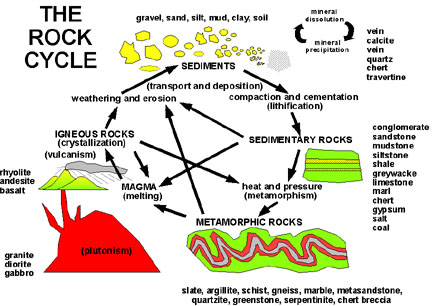 |
Geology is also the story of processes and products formed on or below the Earth's surface. The Rock Cycle, a model that portrays the origin of the three basic rock types (igneous, sedimentary, and metamorphic) and the interrelated nature of Earth materials and processes that transform one rock type into another over time. The diagram also lists the common name of different rocks that can be found in the NYC region. |
| Figure 6. The "rock cycle." |
Igneous rocks form from the cooling and solidification of molten material called magma. This process, called crystallization, may occur beneath the Earth's surface forming intrusive igneous rocks, or following a volcanic eruption on the surface resulting in extrusive igneous rocks. Magma is derived from the melting of pre-existing crustal rocks or from sources below the Earth's crust. The formation and movement of magma in the subsurface is called plutonism (after "Pluto", God of the Underworld). When magma reaches the surface and erupts the process is called vulcanism. A volcano forms as molten rock and solidified volcanic debris are ejected onto the surface. In addition to rock material, large quantities of water vapor and gases are vented from volcanoes. When magma flows on the surface the material is called lava. Early in Earth's history most of the surface probably consisted of igneous material originating from the frictional melting of rocks due to constant meteorite and asteroid bombardment. The heat that currently produces magma has it source deep within the Earth. The heat is, in part, a relic of the original energy transferred by the collisions of asteroids and planetesimals with the young planet enveloped by an embryonic stellar cloud. Additional heat is derived from radiogenic decay and possibly from tidal forces between the Earth, Moon, Sun, and other planets.
Rocks exposed at or near the surface undergo weathering, in which daily influences of the atmosphere and groundwater slowly disintegrate and decompose rocks. Many processes contribute to converting rocks into smaller sediments. For example, rain water may seep into cracks and freeze; the expansion of ice can create tremendous forces: enough to break rock. Likewise, roots penetrate into cracks and expand. Resistant fragments become sediments, whereas soluble compounds dissolve and are carried away by surface- and ground-water. Erosion involves the transport of sediments by an "erosional agent," such as running water, waves, wind, or glacial ice. Rocks are broken down from larger to smaller fragments: boulders, cobbles, gravel, sand, silt, and microscopic clay-sized particles. The finer the particle the easier it is to be transported. In this manner sediments become sorted into size fractions by waves, running water, or wind.
Rock fragments are transported and deposited in a variety of sedimentary environments. On land, sedimentary environments include stream flood plains, swamps, dunes and desert basins. Along the coastal regions sediments accumulate in river deltas, lagoons, beaches, and barrier islands. Most sediments ultimately come to rest in the ocean, accumulating in massive deposits that form the continental shelves, or continuing to the deep basins beyond the shelf margin.
As sediments accumulate, the weight of overlying layers causes compaction. Once-dissolved minerals precipitate in pore spaces cementing grains together. The process of lithification involves the combined effects of compaction and cementation, resulting in the formation of sedimentary rocks. Strata are the parallel layers in sedimentary rocks that generally preserve the gentle, flat-lying surface character of their original depositional environments. Sedimentary rocks frequently contain fossils, the remains, traces, or imprints of plants or animals from the geologic past. They also preserve a host of sedimentary structures including ripple marks, rain-drop impressions, desiccation cracks, and other features that are useful tools for paleoenvironmental interpretation.
Since sedimentary rocks form near the surface, they may ultimately become exposed to weathering and erosion. However, in certain geologic settings such as in a sedimentary basin along the margin of a continent, they may be subjected to increasing burial. As rocks sink further into the crust, heat, pressure, and the interaction of hot mineralizing fluids alter their original chemical composition and physical structures. This process, called metamorphism, results in the formation of metamorphic rocks. Igneous, sedimentary, and pre-existing metamorphic rocks may all be subjected to metamorphism.
Rocks and Minerals
Natural Earth materials, rocks, consist of aggregates of minerals. Minerals
are naturally occurring inorganic compounds having a definitive chemical composition
and crystalline structure. In addition, minerals have many physical characteristics,
such as crystal shape, hardness, range of natural colors, etc. Perhaps most
important to the rock cycle discussion is the mode of mineral formation in different
geologic settings. Some minerals form only in high temperature environments,
such as within cooling magma bodies. Others form only under conditions of extreme
pressure. Still others form only under the cool and wet conditions near the
Earth's surface, or they may result from a variety of different conditions.
Several thousand different minerals have been identified from around the world.
Whereas the vast majority are extremely scarce, several rock forming minerals
occur in great abundance. This is a reflection of the elemental composition
of rocks exposed at the Earth's surface. The relative abundance of elements
in the Earth's crust are illustrated in Table I below.
| Table 1. Relative abundance of elements in the Earth's crust | |
| Element | Percentage by weight |
| Oxygen (O) | 46.1 |
| Silicon (Si) | 28.2 |
| Aluminum (Al) | 8.2 |
| Iron (Fe) | 5.6 |
| Calcium (Ca) | 4.2 |
| Sodium (Na) | 2.4 |
| Potassium (K) | 2.1 |
| All other elements | 3.2 |
| Total: | 100 |
| Source: CRC Handbook of Chemistry and Physics, 1995 | |
The most common minerals are silicates which are composed of silicon and oxygen (the two most abundant elements in the Earth's crust) and varying amounts of other elements. Silicate minerals fall within two general categories: felsic and mafic. Felsic minerals, enriched in silica and aluminum, tend to be light-colored, and are considerably less dense than mafic minerals. Examples of felsic minerals include quartz (SiO2), and varieties of feldspar, orthoclase (K-spar; KAlSi3O8) and plagioclase (several varieties ranging in composition from NaAlSi3O8 - CaAl2Si2O8). Mafic minerals, rich in iron and magnesium, tend to be both dark-colored and denser than most minerals. Examples of mafic minerals include olivine [(Mg,Fe)2SiO4], pyroxene [(Mg,Fe)SiO3], hornblende Ca,Na(Mg,Fe)4(Al,Fe,Ti)3Si8O22(OH)2]. Micas are complex "sheet" silicates easily recognized by their ability to be peeled into paper-thin layers: muscovite is a silvery felsic variety, and biotite is a dark, shiny mafic variety. The igneous rock, granite, is an aggregate of the silicate minerals feldspar, quartz, with lesser amounts of mica or hornblende.
As the rock cycle illustrates, rocks can form in a wide assortment of geologic settings. Rocks differ in their mineral composition and their rock texture. Texture (the size, shape, and distribution of particles that collectively constitute the rock) is a function of the geologic processes related to a rock's formation. For instance, granite is an intrusive igneous rock in which the mineral grains display visible crystal surfaces. These crystals form when the magma cools very slowly within the insulating environment deep within the Earth. If molten material of the same composition were to erupt on the surface the resulting extrusive igneous rock would have the same mineral composition, but would have a different rock texture. When magma cools quickly the minerals have little opportunity to organize and grow. As a result the crystals are microscopic and the rock takes on a very fine-grained texture. The extrusive igneous rock, rhyolite, has the same composition as the intrusive igneous rock, granite.
As rocks form they are subject to change. These changes may represent alterations
in the physical texture or the mineralogical composition. As the rock cycle
demonstrates, active natural processes result in new rock products. The following
examples illustrate these types of processes.
If either granite or rhyolite were subjected to metamorphic processes associated
with deep burial, the resulting rock is called gneiss. Likewise, when certain
combinations of sandstone and shale are subjected to intense metamorphism they
can also become gneiss. Gneiss displays a metamorphic rock feature called banding
or foliation. Foliation is the result of great pressure exerted on a rock, forcing
the realignment and growth of mineral crystals perpendicular to the stress.
Even though granite, rhyolite, and gneiss have the same composition they form
in extremely diverse geologic settings as inferred by their characteristic textures.
The sedimentary rock, limestone, consists of particles of calcite, traces of
other minerals, and organic residues. Calcite is a carbonate mineral (CaCO3)
that is precipitated from seawater effectively by respiration processes in marine
plants and animals. The accumulation of skeletal remains of organisms, such
as corals, algae, shelled critters, and excrement from the creatures that feed
on them, may accumulate on the sea bottom forming reefs or extensive tracts
of lime mud. Upon lithification, these sediments become limestone. With increased
pressure and heat limestone can metamorphose into marble.
Sedimentary rocks that are composed dominantly of sedimentary particles (clasts) are called clastic sedimentary rocks. Sedimentary rocks also form from the accumulation of organic remains or from the precipitation of minerals directly from seawater or water on land. Minerals dissolved by meteoric water (rain, snow, etc.) eventually contribute to the saltiness of the ocean. Natural salt accumulations, called evaporites, form by mineral precipitation reactions driven by evaporative concentration of seawater in restricted marine settings and meteoric water in desert basins. Certain minerals are precipitated by biogenic activity. Biogenic sedimentary rocks form from the accumulation of organic remains consisting of both biogenic mineral and organic residues, such organic reefs, fecal concentrates, bone accumulations, swamp peat accumulations. The combined effects of time, temperature, and pressure, non-mineral organic residues may eventually be converted to coal, oil, gas, and tar.
Accumulating mud in a sedimentary basin or within the ocean consists of varying amounts of silt- and clay-sized particles. Upon compaction, mud becomes shale, a thinly layered, easily friable sedimentary rock. With increasing heat and burial shale is metamorphosed into slate. In this process the original bedding is destroyed and replaced by a metamorphic structure. In the conversion of shale to slate, new layers are created by the growth of mica minerals perpendicular to the lines of stress. Whereas shale readily breaks apart along the original sedimentary bedding planes, slate tends to fracture along the boundaries between the re-oriented mica minerals. This tendency to split in this manner is called rock cleavage. Under increasing heat and pressure the same rock proceeds through additional stages of metamorphism, becoming phyllite, then schist, a rock consisting almost entirely of large mica grains. With increasing heat and pressure mica can convert to feldspar, forming a new rock, gneiss. Gneiss formed originally from mud is essentially impossible to differentiate from gneiss formed from granite, rhyolite, or other pre-existing rocks. Likewise mud, whether derived from granitic mountains, volcanoes, or from pre-existing sedimentary or metamorphic rocks, consists of essentially of identical composition and texture.
Table II illustrates the most common rocks found in the New York City region with notes about their composition and origin. Although the site of a rock's origin may be far inland, processes of erosion, particularly continental glaciation, have transported material seaward. Samples of every rock-type listed below can be found on area beaches.
| TABLE II. Common Rocks in the New York City region. | |||||
| Rock Name | Rock Type | Primary Minerals | Rock Texture | Characteristics Mode of Formation | Occurrence in Region |
| Granite | felsic igneous | K-rich feldspar, quartz, mica, hornblende, plus many accessory minerals | medium to coarse mineral grains | uniform texture slow cooling and crystallization of magma (intrusive igneous) | sporadic intrusions throughout Highlands region |
| Pegmatite | felsic igneous |
feldspar, quartz, mica, plus many accessory minerals | very large interlocking crystals masses | very slow cooling of magma in a restricted intrusion | small masses throughout the Highlands region |
| Basalt | mafic igneous | Na-, Ca-rich feldspar, pyroxene, olivine | very fine to medium grained, uniform texture | shallow intrusive to extrusive mafic igneous rock (volcanic vents and flows) |
ancient volcanic sills and flows in the Newark and Connecticut River Basins |
| Diabase | mafic igneous | Na-, Ca-feldspar, pyroxene | very fine to medium grained, uniform texture | diabase forms from the chemical modification of magma of mafic composition | ancient volcanic sills and flows in the Newark and Connecticut River Basins |
| Gabbro | mafic igneous | Na,Ca feldspar, pyroxene, accessories include hornblende, garnet, biotite mica, magnetite, olivine | coarse mineral grains, uniform texture | many variations ranging from small pockets of magnetite rich hornblendendite to anorthosite massifs slow cooling of magma of mafic composition | occurs throughout Adirondacks region, small intrusions in the Highlands region |
| Shale | clastic sedimentary | clay minerals, quartz silt, organic residues | very fine grained, thinly bedded | deposited in shallow and deep marine and lake settings | massive units in Valley & Ridge, Catskills, Newark Basin and Coastal Plain regions |
| Quartz Sandstone | clastic sedimentary | quartz | sand grains in friable to densely cemented matrix | coastal marine, river flood plains, shallow lakes | Massive units in Valley & Ridge, Catskills, Newark Basin and Coastal Plain regions |
| Arkosic Sandstone | clastic sedimentary | feldspar, quartz, mica, hematite, limonite | fine to very coarse grained sandstone, reddish appearance due to hematite staining in cement | alluvial fans and streams adjacent to mountains | Newark Basin, Catskills |
| Greywacke Sandstone | clastic sedimentary | mixed mafic and felsic minerals | dark-colored fine to medium grained sandstone comprised of a mix of mineral grains | deep water sediments derived from volcanic source areas | Taconic Mountains & Upper Hudson Valley regions |
| Conglomerate | quartz, hematite, limonite | visible quartz pebbles in a sandy, iron-rich matrix | turbulent stream channels, coastal accumulations | Catskills, Valley & Ridge, Coastal Plain regions | |
| Puddingstone | clastic sedimentary | quartz, iron minerals | a variation of conglomerate with large pebbles in a muddy matrix | stream deposits, some glacial deposits |
Catskill and Valley & Ridge regions |
| Limestone | biogenic/chemical sedimentary | calcite | fine to sandy-grained, sometimes abundant fossils | clear shallow marine environments | Valley & Ridge, Hudson Valley |
| Dolostone | biogenic/chemical sedimentary | dolomite | fine to sandy-grained, fossils generally destroyed |
chemically altered limestone | Valley & Ridge, Hudson Valley |
| Marl [greensand] | biogenic and clastic sedimentary | glauconite, calcite, clay minerals | fine to sandy-grained, mix of glauconite and quartz sand with calcareous and organic (mostly fecal) debris, fossils common | shallow marine | Coastal Plain |
| Lignite | biogenic sedimentary | plant remains, pyrite | brown to black loosely consolidated "charcoal-like" plant material, occurs in small lenses | swamp and coastal accumulations | Coastal Plain |
| Coal | biogenic sedimentary | plant remains | brittle, hard, black (bituminous coal) to very hard, shiny black with conchoidal fracture (anthracite coal) | metamorphism of plant remains | Appalachian Basin region |
| Bog Iron Ore | biogenic/chemical sedimentary | iron minerals (limonite, siderite, hematite, goethite) | fine grained, densely cemented mudrock, sometimes preserves plant fragments | precipitated from groundwater in streams or swamps | Coastal Plain, particularly the Pine Barrens region |
| Chert | biogenic/chemical sedimentary | silica (microcrystalline quartz with iron and other elemental impurities) | many colors, fine-grained with a glassy to frosty texture, conchoidal fracture; varieties: red (jasper), banded (agate | precipitates from groundwater, sometimes replaces other rocks | Catskills, Valley & Ridge, Newark Basin |
| Quartzite | metamorphic | quartz | densely cemented or fused quartz grains | metamorphosed sandstone or volcanic ash | Highlands region |
| Slate | metamorphic | mica, quartz, clay minerals | dense mudrock, cleavage surfaces reflect microscopic to visible mica platelets | low-grade metamorphism of shale | Valley & Ridge region |
| Marble | metamorphic | calcite, dolomite | uniform, medium to coarse grained or "sugary" texture, fossils destroyed | metamorphosed limestone or dolomite | Valley & Ridge, Highland region |
| Schist | metamorphic | abundant mica (biotite or muscovite), garnet, quartz, feldspar | coarse grained, mica creates shiny appearance, commonly displays foliation banding | high-grade metamorphism of shale or granitic rocks | Highlands region, especially Manhattan area |
| Gneiss | metamorphic | feldspar, quartz, mica, hornblende, amphibole | medium to coarse-grained, displays foliation banding | high-grade metamorphism of granite or sedimentary rocks | Highlands region |
| Serpentinite | metamorphic | serpentine minerals, sometimes asbestos and other fibrous minerals | medium to coarse grained, greenish gray to black color | metamorphism of mafic rocks | Parts of Staten Island and Highlands region |
Plate Tectonics
The internal structure of the Earth has been revealed by the study of shock
waves generated by earthquakes and subterranean nuclear blasts (Figure 6). The
ball of the Earth consists of several distinct layers. The central inner core
is 1221 km thick and probably has a metallic composition similar to nickel/iron
meteorites. The outer core is molten metallic layer about 2259 km thick. This
is overlain by the mantle, a solid rocky layer having two zones: the lower mantle
(average thickness of 2171 km), and the upper mantle (average thickness of 720
km). The crust is the relatively light outer skin that ranges in thickness between
5 and 40 km. The uppermost hundred kilometers of the mantle and the crust are
called the lithosphere. In general, the lithosphere is both solid and rigid
in character, and it is within this zone that all earthquakes occur. Beneath
the lithosphere, the upper portion of the mantle is so hot that it is near the
point of melting. In this interval the rock behaves in a ductile manner. This
zone is also the source of some magmas that eventually migrate to the Earth's
surface. This region, called the aesthenosphere, extends between 100-700 km
below the Earth's surface. Rocks in this zone are easily deformed, flowing slowly
due to temperature-controlled density currents. The mechanism for this flux
is straightforward: Rock heated from below expands and rises. Near the Earth's
surface, heat conducted slowly toward the atmosphere is ultimately radiated
into space. This heat loss causes the rocks to condense and sink. The thermal
exchange process has been occurring throughout Earth's history, causing material
rise, cool, sink, and heat up again. As a result, the mantle is probably very
homogeneous in composition.
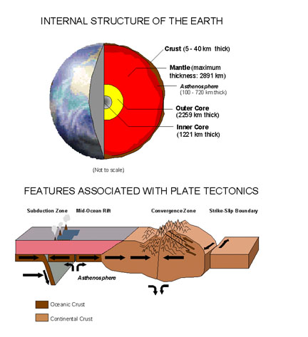 |
| Figure 7. The structure of the earth and a model illustrating plate tectonics. |
Due to the great pressure in the lower mantle the rock cannot melt. Only in the vicinity of aesthenosphere and within the crust where temperatures are high enough will rock material become molten. As a result the crust "floats" on the mantle in a similar manner to the way icebergs float on the sea. Generally, where the crust is thin or of dense composition ocean basins occur. Where the crust is thick or less dense in composition, such as within continents, the land surface rises above sea level. The rising and sinking of material within the mantle drags or pushes the crust of the Earth in the form of great plates (see Figure 7). Where mantle material rises the crust is pulled apart, and great fissures or rifts form. It is along these spreading centers where new ocean crust forms. Igneous rocks produced in these zones are mainly basalts and have a mafic composition. Spreading centers define divergent boundaries of crustal plates. For instance, the Mid Atlantic Ridge, an extensive mountain range that runs down the center of the Atlantic Ocean, is a divergent boundary.
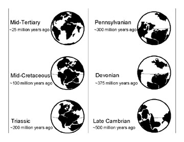 |
| Figure 8. Map of continental arrangement at different times in geologic history (after NY State Regents Earth Science Reference Tables). |
The new crust formed along divergent boundaries is generally both thin and relatively hot. Magma derived from the mantle is typically extremely hot, typically greater than 2000 F. Through time and the rock is carried or pushed away from its place of origin. As the new crust cools it becomes denser. This new basaltic crust generally makes up the rocks underlying the world's ocean basins. Through time, sediments derived from continents blanket the ocean crust forming thick blankets of sedimentary rock.
As new crust is formed older crust is recycled back into the mantle. This occurs along convergent boundaries where crustal plates collide. A convergent boundary exists between two crustal plates where one plate overrides another, usually along the margins of continents. The rock within continental land masses are generally felsic (granitic) in composition and are therefore less dense. As a result continental crust overrides oceanic crust. Oceanic crust sinks back into the aesthenosphere along a subduction zone. Subduction zones consist of a great fault, or series of faults, defining the boundary between two converging crustal plates. As the ocean crust sinks it drags rock material with it, including sediments saturated with seawater. Moving downward, this material heats ups and it gradually or partially melts. In the process, however, a natural refinement process occurs. Minerals that cannot withstand high temperatures (such as quartz) melt first, and minerals that can withstand higher temperatures (such as most mafic minerals) remain solid. As a result the molten material that forms in association with subduction zones is of felsic composition (mainly granite and rhyolite). Above the sinking slab of crust within subduction zones the surface is dotted with both active and extinct volcanoes. For instance, the Ring of Fire (the continental margins around the Pacific Ocean) is a zone where both volcanic eruptions and earthquakes occur in relative abundance; the subduction of the Pacific Ocean crust is responsible for this activity.
Another type of convergent boundary forms when two continental land masses
collide. Because most continental rocks are too light to sink into the mantle,
the rock piles up and forms massive mountain ranges. The best modern example
of this is the Himalayas; the high mountain range formed as the Indian subcontinent
collided into southern Asia beginning about 16 million years ago. Before the
two continents collided, a massive volume of sediments accumulated in a seaway
between the two land masses. Today it is possible to find rocks bearing remains
and traces of marine organisms that lived in that seaway high in the Himalayas.
All crustal plates are in motion. For instance, North America is cruising westward
relative to Europe at a rate of about 4 centimeters per year. (Columbus' journey
would be 20 meters farther now!) This may seem insignificant, but in the framework
of geologic time this process becomes important. For instance, Figure 7 shows
the arrangement of the continents as they existed about 200 million years ago.
At that time all of the continents were assembled in a single, great landmass
named Pangaea. A great, developing rift system slowly gave rise to the Atlantic
Ocean, eventually becoming the spreading center associated with the Mid Atlantic
Ridge. The breakup of Pangaea was gradual, beginning with the opening of the
Mid Atlantic Ocean basin between the east coast of North America and northwestern
Africa. This was followed by opening of the South Atlantic, between Africa and
South America, and finally, the opening in the North Atlantic in the Arctic
regions between Europe, Greenland, and North America. Along the eastern edge
of North America the new oceanic crust fused with the continental crust becoming
one great plate: the North American Plate. As a result, the eastern edge of
the continent became a passive margin. This is in contrast to active margin
along the western edge of North America were subduction and transform faulting
is actively occurring. Transform faults are horizontally-displaced faults associated
with mid-ocean ridges; They develop where spreading rates are not uniform. Transform
faults result from a shearing motion in the crust. This results in the formation
of a fault in which one landmass moves gradually past another. This same type
of shearing also occurs where two plates are sliding past each other. The classic
North American example is the San Andreas Fault in California. Los Angeles and
Baja California are attached to the Pacific Plate, which is slowly grinding
northward relative to eastern side of the fault attached to the North American
Plate.
Plate tectonics is the driving force behind most geologic changes occurring on the surface as well as deep in the crust. The processes associated with plate tectonics through the expanse of geologic time are responsible for the gradual accumulation of continental landmasses through the process of accretion. This complex process is illustrated as follows. As subduction proceeds, more and more light felsic material becomes incorporated into the lithosphere. In this manner small island chains, like the Philippines and Japan, grow steadily larger through time. Throughout Earth history small land masses have been constantly forming and being pushed around by plate motion. Some of these land masses eventually are forced against the edges of continents. Because their overall density is so light, rather than being forced downward in to a subduction zone they become attached along the edge of the continent. In this manner the smaller land masses and the thick sequences of sedimentary deposits caught in between are squashed beneath rising mountain ranges along the continental margin.
The North American continent has grown steadily larger by the slow process of continental accretion. This process began with formation of the Canadian Shield, an ancient assemblage of land masses that now forms the central core of the continent. The rocks of the Canadian Shield are dominantly igneous and metamorphic rocks, roughly between 2.8 -1.8 billion years old, with some rocks preserving radiogenic dates that are much more ancient. At different times in Earth history, the eastern edge of North America was an active margin, undergoing stages of mountain building and continental accretion. Through Late Precambrian time and through much of the Paleozoic Era subduction zones and transform faults developed and vanished, resulting in smaller land masses accreting against the edge of the continent. The rock record throughout the New York City region preserves evidence of these episodes. A period of time when a region is subjected to great crustal upheaval associated with the formation of a mountain range is called an orogeny. During the early period of investigations into the geology of the eastern North America, the great mountain building that resulted in the formation of the Appalachian Mountains was termed the Appalachian Orogeny. The name, Appalachian Mountains, applies to all the hilly and mountainous regions associated with the Appalachian Orogenic Belt, a extensive system of highly deformed sedimentary, igneous, and metamorphic rocks extending along the eastern margin of North America between the Maritime Provinces of Canada into the southeastern United States. Through time, as more information became available it became apparent that the Appalachian Mountains formed from a series of different tectonic upheavals that varied considerably in the time in which they occurred, the crustal processes involved, and the locus of greatest deformation. The Appalachian Orogeny is currently subdivided into several orogenies, each of which left an imprint in the rocks within the New York City region (see Figure 4). The oldest resolved event, the Grenville Orogeny, was a period of a major plutonic, metamorphic, and deformation activity during Late Precambrian time (roughly 1.3 to 0.8 billion years ago) affecting much of the southeastern border of the Canadian Shield. The Taconic Orogeny occurred throughout the region from early in the Ordovician to early in the Silurian. During Middle Paleozoic time, the Acadian Orogeny occurred, mostly affecting the northern Appalachians region. The Alleghenian Orogeny of the Late Paleozoic time refers to deformation most apparently affecting the Valley and Ridge region, particularly in the southern Appalachians. The most recent event, the Palisades Disturbance, involved an orogenic period in which the Newark and Connecticut River Basins (among others) developed early in the Mesozoic.
The relatively mountainous landscape in parts of the region today are a reflection of the ongoing processes of isostatic crustal uplift countering the equally gradual erosion of the landscape through time. Topographic relief in the region largely reflects differing rates of erosion affecting rock types that make up the bedrock, whereas in the past, volcanism and tectonism probably played more dominant roles.
Evolution of Life
The history of the Earth is a story of constant change: mountain ranges are
formed and worn down; seaways receive thick sequences of sediment and vanish
as continental plates collide. As the landscape changed from one geologic period
to the next, so did the organisms that inhabited the environment. The cumulative
knowledge gained from geologic investigations over the past two centuries have
yielded a framework for understanding this progression of changes through time.
Paleontology is the study of deceased organisms from the geologic past. The
chief contributions of this science have been to the knowledge of phylogeny
(the relationships of modern animals and plants to ancestral forms) and to the
establishment of a chronology in Earth history.
A fossil is any remains, trace, or imprint of a plant or animal that has been preserved in the Earth's crust since some past geologic or prehistoric time. The fossil record describes the cumulative knowledge of biological organisms and their activities on Earth though time. This knowledge is preserved in text in libraries and as specimens in museums around the world, and is based on the intellectual study by thousands, if not millions, of people over the course of history. Since new discoveries are continually being made, the study of Earth history is a dynamic field. Unfortunately, the fossil record is extremely incomplete. The preservation of an organism as a fossil is generally a rare exception rather than the rule. The following discussion illustrates the case.
Take for example, a duck which dies in flight. If it falls on land, then opossums, rats, racoons, or other carrion will likely devour all traces of it. Perhaps it wouldn't meet such a fate, and insects, worms, or other invertebrates will consume what remains of the flesh. In time, even the bones will desiccate during exposure, or be broken down by bacterial decay. If it falls into a body of water it is likely to end in a similar manner, eaten by bottom-feeding crustaceans and other scavengers. In a rare chance a few disarticulated bones may eventually be buried in mud. The likelihood of a whole bird being buried would be a complete fluke! Even then, with time, waves and currents rework the bottom sediments, and bacterial and chemical reactions within the sediment are likely to disintegrate and dissolve the last remaining fragments.
For an organism to be preserved as a fossil, it must not only survive the processes of initial burial, but it must endure the continuously changing processes affecting the physical world through time. After surviving the mineralogical changes in the process of becoming fossilized, it must endure the processes of weathering near the Earth surface. Of all the fossils that survive exposure, few are actually found, and even fewer are actually properly collected, identified, described, and interpreted in the literature. Even with these considerations, the fossil record is extremely skewed by the general nature of the sedimentary record. Fossils are preserved only in sediments or sedimentary rocks, or sometimes encased in volcanic ash falls or beneath lava flows. Metamorphism generally demolishes fossils beyond recognition. Most sedimentary rocks represent shallow marine depositional environments. This is because rocks and sediments exposed on land are constantly undergoing erosion and are mostly deposited into shallow waters near shore. Whereas the lesser amount of sediments deposited in the deep ocean are likely to be destroyed by processes associated with subduction.
Certain types of fossils are preserved in great abundance. Examples include ancient coral, stromatoporoid and algal reef or coal swamp accumulations. In the case of reefs, corals and other shelled organisms are buried amongst lime sediments derived from calcareous algae and excrement from animals feeding on the reef. Through time, the skeletal remains, consisting of calcite, are packed in sediments of similar composition. The stability of the geochemical setting helps to preserve the skeletal remains as fossils.
The rapid burial of an organism is likely to increase its chances of becoming preserved as a fossil. In a shallow burial setting invertebrates are likely to churn the sediment searching for food. However, floods or coastal storms may suddenly dump massive amounts of sediment rich in organic material. The abundance of organic material trapped in the sediment promotes the consumption of available oxygen, reducing the activity of burrowing organisms and decay by aerobic bacteria. Shell, bone, or wood are much more likely to survive the processes of burial and decomposition. Once buried, chemical reactions between the remains of the organism, anaerobic bacteria, groundwater, and the host sediment either destroys what is left, or preserves a fossil. Wood is frequently replaced by silica (quartz) producing petrified wood. Bone and shell material typically recrystallizes into a more stable mineral form, or dissolves forming hollow molds. Molds may fill with mineral precipitates forming casts of the original remains.
The theory of evolution is based on the fossil record, and integrating the study of phylogeny and genetics of organisms both living and deceased. The fossil record suggests that life on Earth has developed gradually, from a few simple organisms to many complex organisms, involving numerous adaptations to changing environmental conditions to which they have been exposed through time. Any habitat in which an organism lives is subject to episodic changes in ecological factors to which the organism must adapt, or die. Examples of such variables include seasonal temperature changes, tidal fluctuations, water turbidity, temperature, food supply, oxygen content, shelter, competition, predation, etc. Collectively, a group may survive or face extinction, when an entire population of a species vanishes. Environmental forces cause species to evolve or migrate into new environmental settings.
The fossil record is a progression of species evolving, proliferating, and vanishing into extinction. Some species or genera survive for many millions of years, with abundant specimens preserved in strata around the world. Other species are represented by a single specimen or several specimens derived from a single sedimentary rock layer. The chronology of the evolution of life has been studied in great detail around the world. As a result, different species can be used to define or refine the succession of fossil species. Fossils are used to pinpoint the ages of rocks, and to correlate sedimentary strata or sequences of layers from one location to another. The progression of the evolution of life on Earth is complex: It is a story of gradual succession of species and biological communities punctuated with episodic escalations in change, and catastrophes. The different geologic ages were, in part, defined by the content of the fossil record. Highlights of Earth history are included on the geologic time scale (see Figure 4).
The Precambrian Era encompasses approximately 87% of Earth history, from the solar system's formation about 4.6 billion years ago involving accretion of dust-sized particles to moon-sized objects in a stellar nebula. Roughly four billion years ago the rate of accretion diminished enough form a stable lithosphere, hydrosphere, and atmosphere to develop. The oldest sedimentary rocks on Earth preserve evidence of microbial life more than 3.5 billion years ago. The fossil record for Precambrian time is a story of the evolution and diversification on a cellular level, with highlights including the increasing complexity of cell membranes, development of nuclei and organelles, and the rise of photosynthesis and sexual reproduction. During Late Precambrian time the stability of oxygen-enriched oceans allowed for the proliferation of multicellular organisms, leading to the establishment of all modern phyla.
Although the Late Precambrian oceans probably contained diverse and abundant life, the fossil record is scant. Reasons for this are that the Precambrian organisms did not contain hard parts; the impressions created by soft-bodied organisms are easily destroyed by the processes of lithification. In addition, most rocks of Precambrian age have been exposed to some degree of metamorphism. At the beginning of the Cambrian Period invertebrates with calcareous and phosphatic exoskeletons began to appear in the fossil record. The cause of this Cambrian "explosion" in species diversity and abundance has been the focus of continuous debate among scientists. Theories include factors involving geochemical changes in the global environment (such as the development of the ozone layer); the patchy character of the fossil record; and an "arms race" race driven by competition and predation.
The fossil record of the early Paleozoic Era (encompassing the Cambrian, Ordovician,
Silurian and Early Devonian Periods - ~570-400 million years ago [mya]) is dominated
by various groups of invertebrates, including trilobites, brachiopods, mollusks,
stromatoporoids, echinoderms, and corals. The accumulation of skeletal remains
of these organisms, along with calcareous algae, resulted in the episodic buildup
of reefs in ancient shallow marine settings.
During the Devonian Period significant changes began to appear in the fossil
record. Although fish and sharks had their origins in earlier geologic periods,
they began to have a significant presence in the middle Paleozoic oceans. Concurrently
on land, vascular plants, insects, and amphibians appeared, evolved, and proliferated.
The stratigraphic record preserves the development of shallow inland seas and
extensive coastal swamp lands which peaked in occurrence during Late Paleozoic
time. The Mississippian Period (~360-320 mya) is named for a succession of sedimentary
strata deposited in warm, shallow marine seas throughout the North American
midcontinent. The Pennsylvanian Period (~320-286 mya) is named for the stratigraphic
succession encompassing extensive coal measures throughout the Appalachian region.
During Pennsylvanian time reptiles appeared and flourished.
The fossil record for the close of the Paleozoic Era (~245 mya) is marked by
a catastrophic collapse in ecosystems around the world: the greatest of all
mass extinctions occurred at the end of the Permian Period. Theories proposed
include a catastrophic asteroid impact, and/or drastic atmospheric and oceanic
changes caused, in part, by extensive volcanic eruptions throughout the region
of Siberia. The extinction may have been a consequence of drastic changes in
sea level brought on by the onset of extensive glaciation across the continents
assembled in the southern hemisphere, followed by rapid ocean warming and eutrophication
caused by the sudden melting of massive accumulations of clathrates (a frozen
mixture consisting of methane, carbon dioxide, and water ice that builds up
in porous marine sediments). The extinction may also reflect the general character
of the sedimentary record and the patchy nature of fossil preservation during
that time. Perhaps all these causes and factors may be interrelated. The end
result, however, is that most of the life forms that dominated the Paleozoic
fossil record completely vanished.
The fossil record for the Triassic Period provides evidence for the appearance
and diversification of dinosaurs, flying and swimming reptiles, modern coral
groups, and forests dominated by cycads and conifers. During the Jurassic Period
the earliest birds and mammals appear, but are insignificant by comparison to
dinosaurs. The remains of ammonites, squid-like mollusks with coiled shells,
are preserved in abundance in mudrocks deposited in shallow inland seaways.
The fossil record for the Cretaceous Period records the appearance and diversification
of flowering plants and the development of the bony fishes. The name, Cretaceous,
is derived from the Latin creta, meaning "chalk." Thick chalk deposits
accumulated in shallow inland seas and on the continental margins of North America,
Europe, and Australia.
The close of the Mesozoic is marked by another mass extinction recorded along
the Cretaceous/Tertiary (K/T) boundary. The K/T boundary is a significant interface
preserved in sedimentary sequences around the world. In many locations, an unusual
clay layer enriched in the element iridium marks the boundary. Iridium is an
element that is uncommon in the Earth's crust, but is enriched in meteorites.
After a long search, a massive impact crater buried in sediments was discovered
in the region of the Yucatán Peninsula (Mexico). It is inferred that
an asteroid collided with Earth at a time when many climatic changes were already
in progress. During Cretaceous time sea level was much higher relative to the
landscape than it exists today. As a result, marine waters spread far inland
onto continental shelves and into shallow inland seas. Toward the end of the
Cretaceous the movement of continental plates resulted in the formation of extensive
mountain ranges along the margins of continents around the world. The formation
of mountains and island chains probably drastically changed the flow of atmospheric
and oceanic circulation patterns which had been previously been relatively stable
for many millions of years. Above the K/T boundary many groups of organisms
vanished from the fossil record, including dinosaurs on land, and swimming reptiles
and ammonites in the oceans. Perhaps more intriguing than the animal groups
that became extinct are the ones that survived; many of these are still around
today. By Paleocene time most of the shallow marine seaways vanished. With dinosaurs
out of the way, the Tertiary landscape became host to a progressively diverse
group of modern bird and mammalian lineages.
The pace of evolution of the mammals intensified during mid Tertiary, highlighted by the appearance and diversification of many families of rodents, marsupials, bats, cetaceans, carnivores, primates, and many types of running and grazing animals. During the mid Tertiary Period, the general character of the landscape changed as ground cover dominated by sedges gave rise to modern grasses.
Beginning in the Pliocene Epoch the global temperature began to episodically turn cooler. Perturbations in the global oceanic/atmospheric heat transfer system may have involved the closing of the Isthmus of Panama, the rising of the Himalayan and other mountain ranges, and a variety of other factors. During the Pleistocene Epoch, beginning around 1.6 million years ago, the high latitude regions of the globe were subjected to extensive periods of continental glaciation. Not only were the high latitude regions buried and scoured by ice, but the formation of continental glaciers trapped vast quantities of water on land. As a result, as glaciers advanced, sea level fell by as much as 100 meters, forcing the shorelines to migrate toward the margins of continental shelves around the world. When the glaciers melted during brief warm periods, the sea once again flooded the continental margins. In Equatorial and middle latitude regions, the episodic warming and cooling trends wreaked havoc on ecosystems, changing climates from wet-to-dry, and reverse. These oscillations forced modern species to continuously adapt and migrate to new settings, forcing the evolution of many plant and animal species (including our own) to proceed at an accelerated pace.
The geologic time scale places the end of the Pleistocene Epoch around 10,000 years ago, preceding the brief, warmer Holocene Epoch which includes our modern world. This demarcation around 10,000 years ago is fairly subjective and complex. For instance, parts of the world, like Greenland and Antarctica, are still locked in an ice age. Investigations from around the world show that the most recent glaciation was near its maximum around 18,000 years ago. Evidence derived from deep sea sediments around the world indicate that the oceans warmed significantly around 11,000 years ago. About 10,000 years ago, changing cycles involving the Earth's revolution around the Sun, and variations in its axis of rotation, resulted in a level of maximum intensity of summer sunlight. Corresponding to this time, the global terrestrial biosphere underwent a sudden, major climatic warming. Although the continental ice sheets were still extensive, they were melting rapidly. This period generally corresponds to a mass extinction that occurred, roughly between 12,000 and 9,000 years ago. This extinction includes many species of large mammals including mammoths, mastodons, saber-toothed cats, camels, horses, oxen, giant ground sloths, giant beavers, the American lion, the American cheetah, the dire wolf, the giant short-faced bear, many species of predatory and carrion-eating birds, etc. The cause of this mass extinction is still hotly debated, with theories involving: climatic change; habitat migration and modification; the roles of the growing human population with its advancing hunting technologies, and possibly, the spread of diseases associated with human migrations (and the vermin that followed).
The Stratigraphic Record
The fossil record provides evidence of changing life forms inhabiting different
environmental settings through time. As the discussion above illustrates, the
fossil record is, in many aspects, quite incomplete. However, organic remains
provide only part of the puzzle used for interpreting the geologic history of
a region. The rocks themselves tell the a story. Charles Hutton, a Scottish
physician and gentleman farmer, published his book, Theory of the Earth with
Proof and Illustration, in 1785. Hutton promoted his idea that "the present
is key to the past." Charles Lyell (Principles of Uniformitarianism) expounded
Hutton's ideas, stating that what actually remains "uniform" are the
physical processes and chemical laws that govern geological activity. However,
uniformitarianism, as we understand it today, does not hold that the rates of
geological processes or their precise nature remain the same today as they were
in the past. For instance, the modern landscape is largely covered by vegetation,
whereas much earlier in Earth history this was not the case. The same is true
considering "catastrophic" episodes in the past when Earth was bombarded
by asteroids, or when it experienced massive volcanic outbreaks affecting regions
the size of modern continents. These events, however, are generally an exception
rather than the rule. The vast majority of the rock record represents slow,
gradual processes of deposition or erosion, or gradual processes of mountain
uplift. For instance, the slow annual accumulation of sediments in the waters
around the Mississippi River Delta and other rivers in the region for many millions
of years has resulted in the massive buildup of the Gulf continental shelf which
is many miles thick and covers thousands of square miles.
The reasoning that processes occurring today are similar to processes that have occurred in the past is a useful tool for interpreting Earth history. For instance, an examination of sediments of modern depositional settings, such as a river delta, a barrier island, or a coastal swampland yield examples of information that may be used for interpreting ancient depositional environments preserved in sedimentary rocks. The science of stratigraphy involves the examination of sequences of rocks to determine the chronology of changing depositional environments through time. Although stratigraphy generally involves the examination of sedimentary deposits, the data gathered from stratigraphic investigations have helped to unravel the more complex history of metamorphic and igneous rocks in the region. Rocks not only record the processes that created them, but often provide evidence of the complex changes to which they have been subjected over time. Unraveling the complex history of a region often requires relative dating, a method utilizing several geologic principles in which rocks are placed in their proper sequence or chronological order. The Law of Original Horizontality states that sediments tend to accumulate in flat or nearly flat layers. The inference that in an undeformed sequence of sedimentary rocks or lava flows, each layer is older than the one above it (and younger than the one below it) is called the Law of Superposition. The Law of Cross-Cutting Relationships describes that a rock (or fault) is younger than any rock (or fault) through which it cuts.
Where relative dating establishes the order in which processes occurred, determining the actual time of a particular event involves methods of correlation and absolute dating. Correlation incorporates the Principle of Faunal Succession by the assumption that fossil organisms succeed one another in a definite and determinable order, and therefore any time period can be recognized by its fossil content. Absolute dating is the determination of the number of years since the occurrence of a given geologic event, and involves the use of a variety of geochemical and radiogenic methods.
When rock layers appear to have been deposited essentially without interruption, the stratigraphic succession is described as conformable. However, in almost all regions there are "gaps" in the stratigraphic record. These gaps, called unconformities, represent periods of time when sediments were not deposited, or when erosion removed previously formed rocks before deposition resumed. Unconformities represent important aspects of geologic history, such as the withdrawal of a seaway or a period of uplift followed by erosion. Unconformities, like rock layers, can be correlated from one area to the next.
There are several types of unconformities (Figure 8). A disconformity separates rock layers that are parallel. However, fossils or absolute dates may indicate that the gap between layers correspond to an extensive time period. An angular unconformity is an unconformity in which the older strata dip at an angle different from that of the younger beds. Angular unconformities suggest that an episode of tectonism occurred, such as folding or faulting associated with a mountain building period, followed by a period of erosion before sedimentation resumed. A nonconformity is an unconformity that separates younger sedimentary rocks from older igneous or metamorphic rocks. Like an angular unconformity, a nonconformity may suggest an extensive period of uplift and erosion before the younger sediments were deposited.
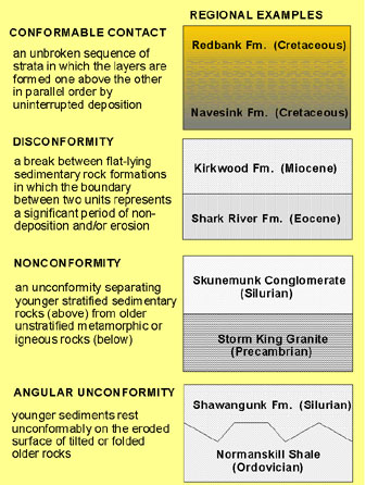 |
| Figure 9. Types of unconformities. |
The remainder of this e-book examines of the geologic history of the New York City region. Chapters are arranged by geographically and according to shared lithologic modes of origin. We begin with the most ancient rocks of the Highlands region; followed by the Mesozoic rocks of the Newark and Connecticut River Basins; the Cretaceous and Tertiary sedimentary rocks of the Atlantic Coastal Plain; and finally, the coastal setting of our modern world (which was heavily affected by geologic processes related to periods of glaciation and erosion), and the introduction of a new agent of geologic change: humans!