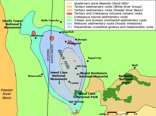
Geology Highlights: The core of the Black Hills are Precambrian (Proterozoic) age metamorphic rocks and intrusive igneous rocks. These crystalline basement rocks include the Harney Peak Granite, the bedrock host for the presidental scuptures on Mount Rushmore National Memorial and is the bedrock of Harney Peak, the highest point in South Dakota and the Black Hills. The Harney Peak Granite is coarse-grained muscovite granite and pegmatite containing accessory minerals including garnet, biotite, and tourmaline. The crystalline basement rocks are characterized geochemically as having high concentrations of beryllium, boron, lithium, and uranium. These granitic rock intruded older metamorphosed sedimentary and igneous rocks of Early Proterozoic age (DeWitt and others, 1989).
Two of the world's largest and oldest cavern systems are Wind Cave and Jewel Cave. Both caverns are in the upper Pahasapa Limestone (Lower Mississippian). The cavernous limestone is overlain by a protective sandstone caprock: Minnelusa Formation ( Pennsylvanian and Early Permian). These rock formations and other older Paleozoic sedimentary formations crop out in a belt around the core of the Black Hills where the Proterozoic crystalline basement rocks are exposed. This belt of limestone is host to an ancient and large karst region, with cavernous features and associated mineral deposits that date back at least 10 million to as much as 40 million years. The fractures associated with the brecciated limestones and box-work features in the caverns may be even older (Tuttle and Harris, 1990).
Devils Tower is an volcanic neck of Eocene age in the northwestern end of the broad Laramide-age structural upwarp that includes the modern Black Hills. The volcanism at Devils Tower and at other locations in the northern Black Hills occurred at the end of the Laramide Orogeny. Before the Laramide Orogeny began about 70 million years ago, the Black Hills area was near the middle of the Cretaceous Western Interior Seaway.
The sediments that eroded from the Black Hills and other regional Laramide uplifts accumulated as the sedimentary rock formations of the White River Group. These rocks are exposed and preserved in Badlands National Park. The terrestrial sedimentary deposits of the White River Group rest unconformably on sediments deposited in the Western Interior Seaway. Cretaceous age sedimentary rocks of marine origin are exposed along river valleys throughout the unglaciated high plains of western South Dakota west of the Missouri River, including within the Sage Creek Wilderness Area in Badlands National Park.
Younger Quaternary deposits in the unglaciated Black Hills region include stream valley fill, local dunes and loess deposits, and elevated river gravel (terrace) deposits. Terrace gravel deposits commonly appear as step-like erosional benches along stream valleys, especially the principal streams draining from the Black Hills.
Selected References
DeWitt, E., Redden, J. A., Buscher, D., and Wilson, A. B., 1989, Geologic Map of the Black Hills area, South Dakota and Wyoming: U.S. Geological Survey Miscellaneous Investigations Series Map I-1910. Scale 1-250,000.
Karner, F. R. and Lalvorson, D. L., 1987, The Devils Tower, Bear Lodge Mountains, Cenozoic igneous comples, northeastern Wyoming: in Rocky Mountain Section of the Geological Society of America, Beus, S. S., editor, Boulder, Colorado: Geological Society of America Centennial Field Guide Volume 2, p. 161-164.
Stoffer, P. W.,2003, Geology of Badlands National Park, a preliminary report: U.S. Geological Survey Open-File Report 03-35, 65 p. Available on-line at: http://geopubs.wr.usgs.gov/open-file/of03-35/.
Tuttle, A. and E. Harris, 1990, Wind Cave, in: Geology of National Parks, 4th Edition: Kendall/Hunt Publishing Company, p. 159-166.