Riverside County, California
See nearby Joshua Tree National Park or Painted Canyon Geological Area.
See Selected References.
| Coachella Valley Preserve
Thousand Palms Oasis Riverside County, California |
||||
|
||||
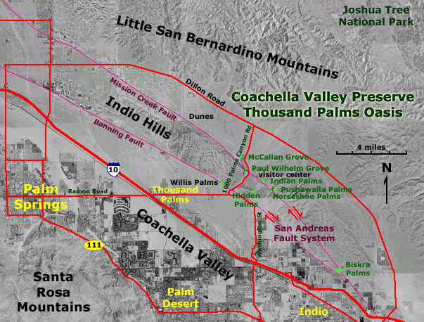
| The Coachella Valley Preserve is located on the trace of the
San Andreas Fault between the towns of Palm Springs and Indio, California.
The main groves of the preserve are called the Thousand Palms Oasis. A visitor
center is located in the Paul Wilhelm Grove along Thousand Palms Canyon
Road. Springs rising along the Mission Canyon Fault and Banning Fault (parallel
strands of the San Andreas Fault System). The springs are host to Desert
Fan Palms (Washingtonia filifera) (Howard, 1994). The preserve began with the purchase
of 1,920 acres of the proposed site by the California Nature Conservancy.
It was expanded by the support of the U.S. Fish and Wildlife Service, The
U.S. Bureau of Land Management, and is now owned by the Nature Conservancy.
The preserve now encompasses 17,000 acres, protecting three separate desert
dune fields and six palm forests (over 1,500 palms). It is part of a 20,000
acres dedicated to protect the habitat of the Coachella Valley Fringe-toed
Lizard and other species. The preserve covers a large portion of the Indio
Hills in the valley west of Joshua Tree National Park (Coachella Valley Preserve, 2009). See nearby Joshua Tree National Park or Painted Canyon Geological Area. See Selected References. |
 |
This website contains images produced from stereo photo pairs that were manipulated into anaglyphs (3-D images). You will need red-and-cyan stereo viewing glasses to get the 3-D visual effects. Photography on this website was taken in winter 3003-2004. |