Geologic River Tour of the Grand Canyon (in 3D)
These selected images were taken during a raft trip down the Grand Canyon starting at Lees Ferry (River Mile 0)
and ending at Lake Mead National Recreation Area.
Click on any image for a larger view.
Switch to Standard Photography.
|
|
|
|
|
|||||
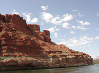
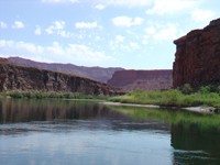
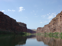
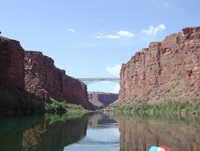
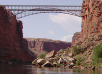
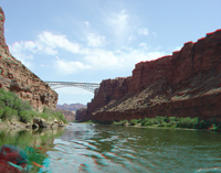
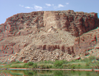
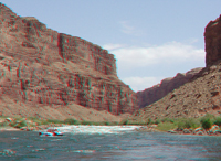
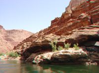
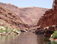
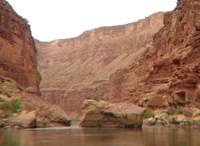
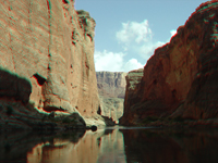
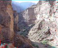
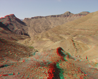
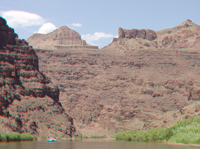
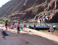
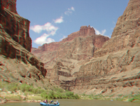
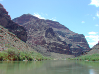
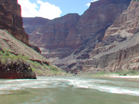
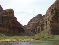
| ~ Mile 0: Contact of Moenkopi Formation and underlying Kaibab Limestone at Lees Ferry | ~ Mile 0: View up Colorado River toward lower Glen Canyon from the Lees Ferry river expedition launch site | ~ Mile 1: Still water on the Colorado River below Lees Ferry entering Marble Canyon | ~ Mile 3: Approaching Navajo Bridge over Marble Canyon and the Colorado River | ~ Mile 4: Rock fall on cliff below Navajo Bridge | |||||
|
|
|
|
|
|||||
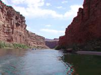
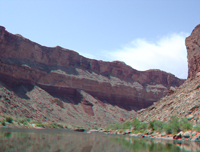
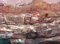
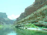
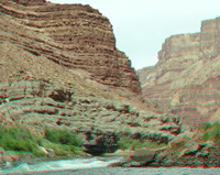
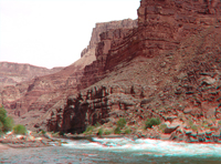
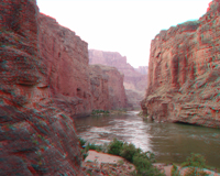
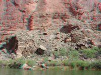
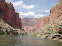
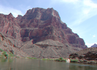
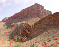
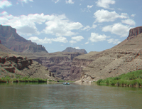
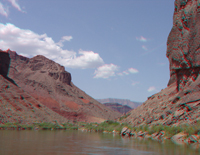
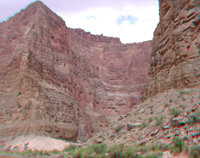
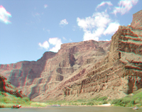
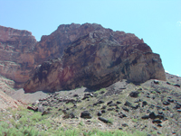
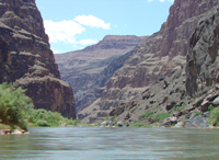
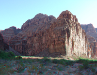
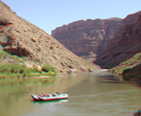
| ~ Mile 5: View looking downstream in Marble Canyon below Navajo Bridge | ~ Mile 5: View looking back upstream toward Navajo Bridge. Coconino (cliff), Toroweap (slope), and Kaibab (cliff) from bottom to top on right | ~ Mile 6: A fairly "fresh" (recent) massive rock fall from the Kaibab Limestone onto the north bank of the Colorado River | ~ Mile 8: View looking upstream at Badger Creek Rapids in Marble Canyon | ~ Mile 9: Talus ramps on the Hermit Shale (lower slope) on the south bank of the Colorado River in Marble Canyon | |||||
|
|
|
|
|
|||||
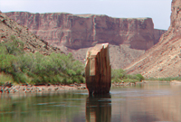
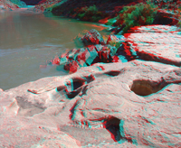
| ~ Mile 10: Ten Mile Rock, a large slab of sandstone imbedded in the Colorado River in Marble Canyon | ~ Mile 10: Ten Mile Rock, a large slab of sandstone imbedded in the Colorado River in Marble Canyon | ~ Mile 13.5: Sandstone ledges in the upper Supai Group on the north bank of the Colorado River | ~ Mile 13.5: A log left behind by a "pre-Glen Canyon Dam" flood resting on ledges of the Supai Group on the south bank of the Colorado River | ~ Mile 14: View looking downstream in Marble Canyon | |||||
|
|
|
|
|
|||||
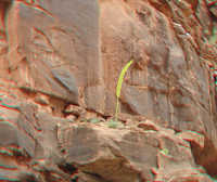
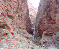
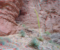
| ~ Mile 14: View looking down Marble Canyon above Sheer Wall Rapid from ledges of the Esplanade Sandstone in the Supai Group | ~ Mile 14: View looking upstream (east) at Marble Canyon. Cliffs of Supai Group (Esplanade Sandstone) are along the river | ~ Mile 14: View looking up through a pothole in a ledge of Esplanade Sandstone carved by the swirling water of the Colorado River | ~Mile 14.5: View of a slot canyon (Tanner Wash) carved in the Esplanade Sandstone on the south side of the Colorado River | ~ Mile 15: View of a blooming agave on sandstone ledges of the Wescogame Formation | |||||
|
|
|
|
|
|||||
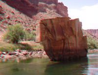
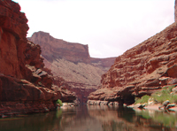
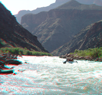
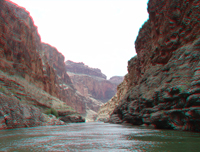
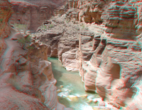
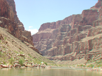
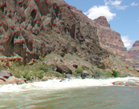
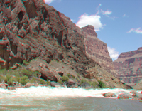
| ~ Mile 18.5: View of a great sandstone boulder in the Colorado River in Marble Canyon | ~ Mile 23: View looking downstream near where top of the Redwall Limestone first appears in Marble Canyon | ~ Mile 25.5: View looking downstream along the Colorado River from above Cave Springs Rapid | ~ Mile 25.6: View looking upstream along the Colorado River from below Cave Springs Rapid | ~ Mile 31.8: Springs issue from a cliff of Redwall Limestone at Vasey's Paradise in Marble Canyon | |||||
|
|
|
|
|
|||||
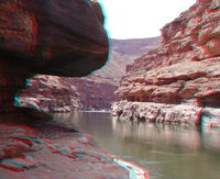
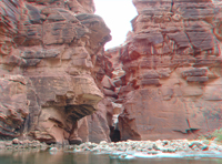
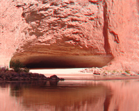
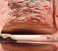
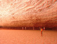
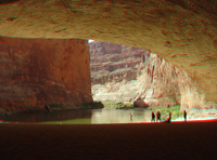
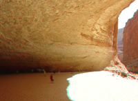
| ~ Mile 32: Upstream view of rapids on the Colorado River with cliffs of Redwall Sandstone (on the left) | ~ Mile 33: Redwall Cavern, a large natural alcove in the Redwall Limestone on the south side of the Colorado River | ~ Mile 33: Redwall Cavern, a large natural alcove in the Redwall Limestone on the south side of the Colorado River | ~ Mile 33: Redwall Cavern, a large natural alcove in the Redwall Limestone on the south side of the Colorado River | ~ Mile 33: Redwall Cavern, a large natural alcove in the Redwall Limestone on the south side of the Colorado River | |||||
|
|
|
|
|
|||||
| ~ Mile 33: Redwall Cavern, a large natural alcove in the Redwall Limestone on the south side of the Colorado River | ~ Mile 33: Redwall Cavern, a large natural alcove in the Redwall Limestone on the south side of the Colorado River | ~ Mile 34: Stillwater and cliffs of Redwall Limestone in Marble Canyon | ~ Mile 34.5: View of Marble Canyon from near the mouth of Nautiloid Canyon | ~ Mile 34.5: Chasm and dry falls near the mouth of Nautiloid Canyon | |||||
|
|
|
|
|
|||||
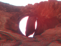
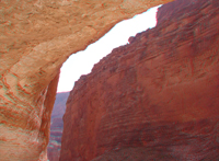
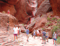
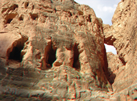
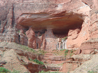
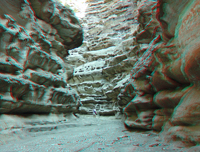
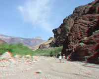
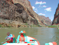
| ~ Mile 34.5: Chasm and dry falls near the mouth of Nautiloid Canyon. An agave bloom is on the left | ~Mile 34.5: Agave plants at Nautiloid Canyon | ~Mile 34.5: Canyon adventures looking at fossils in the Redwall Limestone at Nautiloid Canyon | ~ Mile 35.7: The "Bridge of Sighs" and three large alcoves in the Redwall Limestone on the north side of the Colorado River in Marble Canyon | ~ Mile 41.7: "Royal Arches" are cavernous alcoves with seeps in Redwall Limestone along the north side of the Colorado River in Marble Canyon | |||||
|
|
|
|
|
|||||
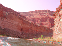
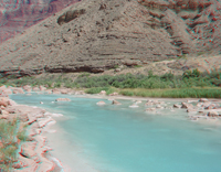
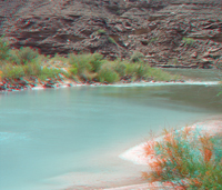
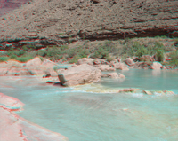
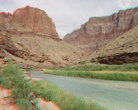
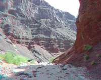
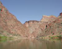
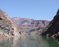
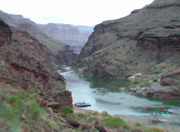
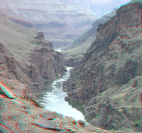
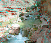
| ~ Mile 42.5: Large slumped blocks of Temple Butte Limestone rest on the south bank of the Colorado River. Mesquite grows along the pre-dam floodline | ~ Mile 45: View looking downstream in Marble Canyon. Grayish ledges of Temple Butte and Muav Limestone crop out along the Colorado River | ~ Mile 61: View looking downstream toward the mouth of the Little Colorado River canyon (on left). The river confluence defines the boundary between Marble Canyon (upstream) and the Grand Canyon (downstream) | ~ Mile 61.5: The Little Colorado River is colored blue by a high concentration of dissolved mineral material. It turns a dirty reddish brown from suspended sediments during floods | ~ Mile 61.5: Warm blue water of the Little Colorado River mixes with the cold green water of the Colorado River at the confluence | |||||
|
|
|
|
|
|||||
| ~ Mile 61.5: Large boulders in the Little Colorado River reveal the powerful forces associated with floods | ~ Mile 61.5: View upstream in the lower Little Colorado River canyon near the confluence with the Colorado River | ~ Mile 64.5: View downstream from near the mouth of Carbon Canyon. Morning light shines on the South Rim in the vicinity of the Desert View Watchtower | ~ Mile 64.5: Lower Carbon Canyon | ~ Mile 64.5: Narrows in lower Carbon Canyon | |||||
|
|
|
|
|
|||||
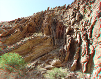
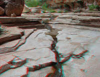
| ~ Mile 64.5: Folded Precambrian-age sedimentary strata about 1.5 miles upstream along Carbon Canyon | ~ Mile 64.5: Folded Precambrian-age sedimentary strata about 1.5 miles upstream along Carbon Canyon | ~Mile 65.5: View of sedimentary rocks of the Dox Sandstone of Precambrian age in upper Lava Creek drainage (about a mile south of the Colorado River) | ~Mile 65.5: View of cliffs of Precambrian-age Cardenas Basalt (above) over sedimentary beds of the Dox Sandstone in the Lava Creek drainage (about a half mile south of the Colorado River) | ~Mile 65.5: Desiccation cracks preserved in Precambrian-age sedimentary beds of the Dox Sandstone in the Lava Creek drainage (about a half mile south of the Colorado River) | |||||
|
|
|
|
|
|||||
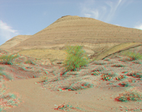
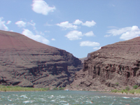
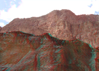
| ~Mile 65.5: Barren hills of sedimentary beds of the Precambrian-age Chuar Group in the Lava Creek Drainage | ~Mile 65.5: Dark red Precambrian-age Dox Sandstone crops out near the mouth of Lava Creek | ~Mile 65.5: The confluence of Lava Creek and the Colorado River. Dox Sandstone (red) and Cardenas Basalt (gray) crop out on the south side of the river | ~ Mile 68: Dark cliffs formed on exposed face of a Precambrian-age volcanic sill (consisting of diabase); Dox Sandstone is below the sill, and Nankoweap Formation is above the sill | ~ Mile74: View looking downstream at Nevills Rapid at cliffs of inclined sedimentary beds of the Precambrian-age Shinumo Quartzite | |||||
|
|
|
|
|
|||||
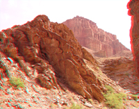
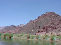
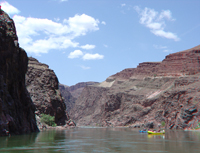
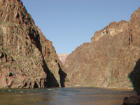
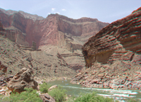
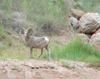
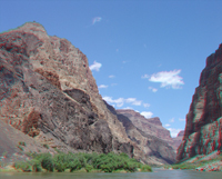
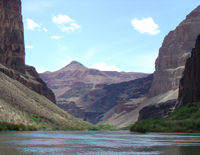
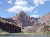
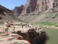
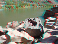
| ~ Mile74.5: View looking upstream at cliffs of inclined sedimentary beds of the Precambrian-age Shinumo Quartzite | ~ Mile 75: Rising cliffs of sedimentary rocks of the Precambrian Grand Canyon Series near the mouth of Papago Creek | ~ Mile 76: Downstream view of red slopes consisting of the Hakatai Shale overlain by cliff exposures of Shinumo Quartzite | ~ Mile 77: A desert bighorn sheep stands on blocks of Bass Limestone along the banks of the Colorado River | ~ Mile 78.5: The Colorado River enters the inner Granite Gorge of the Grand Canyon | |||||
|
|
|
|
|
|||||
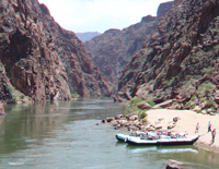
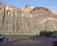
| ~ Mile 81.5: A Colorado raft trip stops at a small sandy beach near the mouth of Grapevine Creek in the upper Granite Gorge | ~ Mile 84: The mouth of Clear Creek canyon where it meets the Colorado River in the Granite Gorge | ~ Mile 84: A blooming agave grows on an outcrop Vishnu Schist along Clear Creek | ~ Mile 84: The narrow gorge of Clear Creek is cut into the Precambrian Vishnu Schist | ~ Mile 84: A short hike of Clear Creek canyon leads to a waterfall that has a horizontal splash zone | |||||
|
Click here to take a "detour" to the Phantom Ranch, and the Kaibab and Bright Angel Trails (between river miles ~87-89) | |
|
|
|||||
| ~ Mile 84: Erosion by the Colorado River carved these smooth and irregular shaped surfaces of the Vishnu Schist near the mouth of Clear Creek | ~ Mile 90: View looking downstream in the Granite Gorge in the vicinity of Corn Creek Rapid | ~ Mile 91.5: A raft crew sets up evening camp on a sand bar near the mouth of Trinity Creek | ~ Mile 95: A raft running Hermit Rapid in the Granite Gorge | ||||||
|
|
|
|
|
|||||
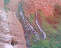
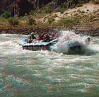
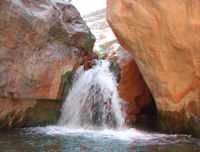
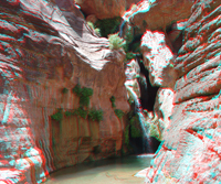
| ~ Mile 95: A raft slashing through the waves on Hermit Rapid | ~ Mile 99: Approaching Tuna Creek Rapid in the Granite Gorge | ~ Mile 106.5: Approaching the western end of the Granite Gorge | ~ Mile 108.5: Falls along Shinomo Creek near the Colorado River | ~ Mile 116.5: Elves Chasm in Royal Arch Creek canyon | |||||
|
|
|
|
|
|||||
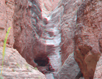
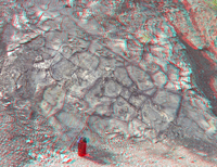
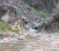
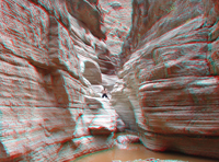
| ~ Mile 116.5: View looking downstream from the Elves Chasm area toward cliffs in the Tapeats Sandstone (on the right) | ~ Mile 120: The Great Unconformity is well exposed along lower Blacktail Canyon | ~ Mile 120: View of the narrow slot of lower Blacktail Canyon and the Great Unconformity (between the Precambrian Vishnu Schist and the overlying Cambrian Tapeats Sandstone | ~ Mile 133: View looking upstream in the vicinity below Mile 133 Rapid | ~ Mile 133.5: View downstream of a large Precambrian-age (Middle Proterozoic) volcanic sill exposed along the north bank of the river | |||||
|
|
|
|
|
|||||
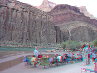
| ~ Mile 133.5: Late afternoon sun shines on cliffs consisting of a large Precambrian-age volcanic sill below red Hakatai Shale exposed along the north bank of the river | ~ Mile 133.5: A Bighorn Sheep ram along the Colorado River | ~ Mile 133.5: An evening biology lecture in the "tidal zone" along the Colorado River | ~ Mile 135: A raft enters the Granite Narrows at the head of the Little Granite Gorge | ~ Mile 136.5: Deer Creek Falls cascade from the Tapeats Sandstone | |||||
|
|
|
|
|
|||||
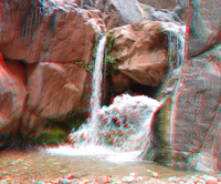
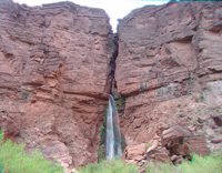
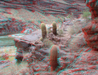
| ~ Mile 136.5: Barrel Cactus along the Deer Creek Trail | ~ Mile 136.5: View looking upriver toward the Little Granite Gorge from along the Deer Creek Trail | ~ Mile 136.5: Zoomed-in view looking upriver toward the Little Granite Gorge from along the Deer Creek Trail | ~ Mile 136.5: Looking up the chasm in the Tapeats Sandstone along the Deer Creek Trail | ~ Mile 136.5: Looking into the chasm carved into the Tapeats Sandstone along Deer Creek | |||||
|
|
|
|
|
|||||
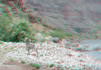
| ~ Mile 136.5: A small waterfall near the head of the chasm along Deer Creek | ~ Mile 136.5: Looking down over al waterfall near the head of the chasm along Deer Creek | ~ Mile 136.5: Fossil worm burrows in Cambrian age sediments in the Tapeats Sandstone | ~ Mile 140: A Bighorn Sheep along the bank of the Colorado River | ~ Mile 140: A Bighorn Sheep on a gravel bar along the Colorado River | |||||
|
|
|
|
|
|||||
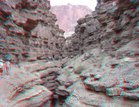
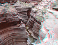
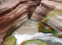
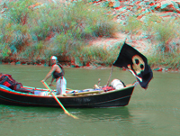
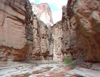
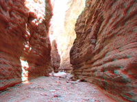
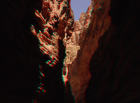
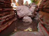
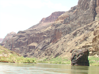
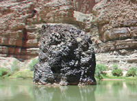
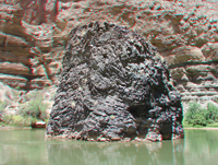
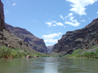
| ~ Mile 142: Pirate in the Grand Canyon | ~ Mile 143.5: The mouth of Kanab Creek Canyon on the north side of the Colorado River | ~ Mile 147: Looking downstream along the Colorado River | ~ Mile 148: Stream-polished Cambrian-age limestone ledges in Matkatamiba Canyon | ~ Mile 148: Matkatamiba Canyon | |||||
|
|
|
|
|
|||||
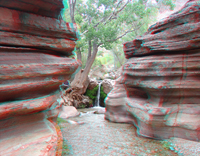
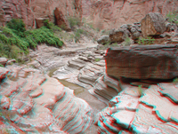
| ~ Mile 156.5: Havasu Creek near the confluence with the Colorado River | ~ Mile 156.5: Havasu Creek gorge near the confluence with the Colorado River | ~ Mile 165.3: Narrows, pools, and falls in National Canyon | ~ Mile 165.3: Boulders in the streambed in National Canyon | ~ Mile 165.3: The narrow gorge of lower National Canyon | |||||
|
|
|
|
|
|||||
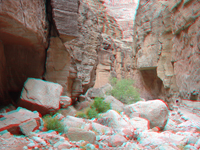
| ~ Mile 168: The narrow gorge of Fern Glen Canyon | ~ Mile 168: The narrow gorge of Fern Glen Canyon | ~ Mile 168: A pool and boulder jam in Fern Glen Canyon | ~ Mile 174: View looking downstream in the vicinity of Cove Canyon, a tributary on the north side of the river (right) | ~ Mile 174.5: View looking downstream at Cove Canyon toward the Red Slide and Toroweap Overlook area | |||||
|
|
|
|
|
|||||
| ~ Mile 175: The Red Slide, a massive "young" landslide in Quaternary alluvium on the north side of the river near Toroweap | ~ Mile 176: Looking down river at the massive cliffs below the Toroweap Overlook | ~ Mile 177.8: Approaching Vulcan's Anvil below the Toroweap Overlook area | ~ Mile 178: Vulcan's Anvil is thought to be a remnant of a basaltic volcanic plug or stock of latest Tertiary to Quaternary age | ~ Mile 178: Vulcan's Anvil is the first visible indication of volcanic activity see along the river for about the next 75 miles | |||||
|
|
|
|
|
|||||
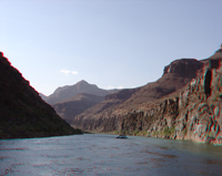
| ~ Mile 178.5: Looking downstream at remnants of massive volcanic flows that poured into the Grand Canyon in Quaternary time | ~ Mile 178.8: A volcanic cinder cone sits on the edge of the rim on the south side of the canyon | ~ Mile 179: Remnant of a large volcanic stock juts out from the south side of the Grand Canyon | ~ Mile 179: Looking dow river toward Lava Falls Rapid with lava flows cascades from the north side of the canyon in the distance | ~ Mile 179.5: A raft entering Lava Falls Rapid, one of the largest rapids in the Grand Canyon | |||||
|
|
|
|
|
|||||
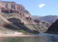
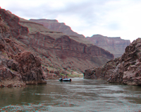
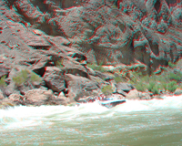
| ~ Mile 179.5: A raft in Lava Falls Rapid | ~ Mile 179.5: looking up river from below Lava Falls Rapid | ~ Mile 182: Classic view of Colorado River boatmen in action | ~ Mile 182: Basalt flows and Paleozoic rocks in the Grand Canyon | ~ Mile 185: Small rapids with lava flows along-side and flowing-into the Grand Canyon | |||||
|
|
|
|
|
|||||
| ~ Mile 186.5: View downstream toward cliffs of Paleozoic rocks, lava flows, and a cinder cone on the north rim of the canyon | ~ Mile 186.5: Looking up at a basalt flow and the cliff of the Redwall Limestone on the north side of the canyon | ~ Mile 188: Lava flows near Whitmore Wash | ~ Mile 198.5: The confluence of Parashant Wash | ~ Mile 198.5: The mouth of Parashant Wash in morning light | |||||
|
|
|
|
|
|||||
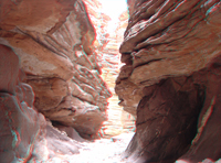
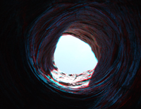
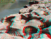
| ~ Mile 212: View looking up river below Fall Canyon | ~ Mile 212.5: potholes in the Tapeats Sandstone along the Colorado River | ~ Mile 212.5: Looking up through toward the entrance to a large pothole in the Tapeats Sandstone | ~ Mile 212.5: potholes in the Tapeats Sandstone along the Colorado River | ~ Mile 212.6: Exploring potholes in the Tapeats Sandstone along the Colorado River | |||||
|
|
|
|
|
|||||
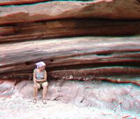
| ~ Mile 212.7: A person sitting in a ppotholes in the Tapeats Sandstone along the Colorado River | ~ Mile 212.7: potholes in the Tapeats Sandstone along the Colorado River | ~ Mile 213: Pumpkin Spring, a travertine terrace along the south shore of the Colorado River | ~ Mile 214: Basalt flows near the mouth of 214 Mile Canyon | ~ Mile 215.5: View looking north from Three Springs Canyon (side side of the Colorado River) toward cliffs, alluvial cones, and basalt flows on the north side of the river |