Wingate Formation
Wingate Sandstone of Glen Canyon Group (AZ*,CO*,NM*,UT*)
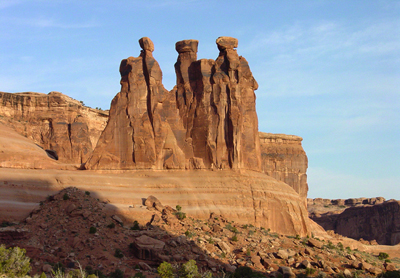
Wingate Sandstone typically forms massive cliffs above the shaley Chinle Formation everywhere where they occur throughout the Colorado Plateau. This Wingate Formation makes up the Three Gossips in Arches National Park.
Jurassic, Early*
Sinemurian*
Black Mesa basin*
Plateau sedimentary province*
Paradox basin*
San Juan basin*
AZ(n)*
CO*
NM(nw)*
UT(s)*
Type Locality:
Not designated. Probably named for Fort Wingate, McKinley Co., NM (Dutton,
1885).
(alphabetical): Lukachukai Member (AZ,CO,NM,UT), Rock Point Member (AZ,CO,NM,UT).
Named provisionally (Dutton, 1885). Revised (Gregory, 1916). Areal limits (Gilluly and Reeside, 1928). Revised; Areal limits (Gregory and Moore, 1931). Revised (Baker, 1936). Overview (Baker and others, 1936). Areal limits; Revised (Kelley and Wood, 1946). Not used (Averitt and others, 1955). Areal limits (O'Sullivan and Beaumont, 1957). Divided into Rock Point and Lukachukai members (Harshbarger and others, 1957). Not used (Griggs and Read, 1959). Areal limits (Poole and Stewart, 1964). Replaced by Iyanbito Member in Gallup-Grants area (Green, 1974). Overview (Peterson and Pipiringos, 1979). Age modified (Padian, 1989). Rock Point Member reassigned to Chinle Formation (Dubiel, 1989). [See Dubiel and others (1992) comments on Chinle Formation correlation with sandstones in northern UT and western CO.]
References
Dutton, C.E., 1885, Mount Taylor and the Zuni plateau: U.S. Geological Survey Annual Report, 6, p. 113-198.
Gregory, H.E., 1916, The Navajo country: U.S. Geological Survey Water-Supply Paper, 380, 219 p.
Gilluly, James and Reeside, J.B., Jr., 1928, Sedimentary rocks of the San Rafael Swell and some adjacent areas in eastern Utah, IN Shorter contributions to general geology, 1927: U.S. Geological Survey Professional Paper, 150-D, p. D61-D110.
Gregory, H.E. and Moore, R.C., 1931, The Kaiparowits region, a geographic and geologic reconnaissance of parts of Utah and Arizona: U.S. Geological Survey Professional Paper, 164, 161 p.
Baker, A.A., Dane, C.H. and Reeside, J.B., Jr., 1936, Correlation of the Jurassic formations of parts of Utah, Arizona, New Mexico and Colorado: U.S. Geological Survey Professional Paper, 183, 66 p.
Baker, A.A., 1936, Geology of the Monument Valley-Navajo Mountain region, San Juan County, Utah: U.S. Geological Survey Bulletin, 865, 106 p., Also, U.S. Geological Survey Oil and Gas Investigations Map OM-168, and Bulletin 1087-D.
Kelley, V.C. and Wood, G.H., Jr., 1946, Geology of the Lucero uplift, Valencia, Socorro, and Bernalillo Counties, New Mexico: U.S. Geological Survey Oil and Gas Investigations Map, OM-47, 1 sheet, scale 1:63,360.
Averitt, Paul, Wilson, R.F., Detterman, J.S., Harshbarger, J.W. and Repenning, C.A., 1955, Revisions in correlation and nomenclature of Triassic and Jurassic formations in southwestern Utah and northern Arizona: American Association of Petroleum Geologists Bulletin, v. 39, no. 12, p. 2515-2524.
Harshbarger, J.W., Repenning, C.A. and Irwin, J.H., 1957, Stratigraphy of the uppermost Triassic and the Jurassic rocks of the Navajo country: U.S. Geological Survey Professional Paper, 291, 74 p.
O'Sullivan, R.B. and Beaumont, E.C., 1957, Preliminary geologic map of western San Juan basin, San Juan and McKinley Counties, New Mexico: U.S. Geological Survey Oil and Gas Investigations Map, OM-190, 1 sheet, scale 1:125,000.
Griggs, R.L. and Read, C.B., 1959, Revisions in stratigraphic nomenclature in Tucumcari-Sabinoso area, northeastern New Mexico: American Association of Petroleum Geologists Bulletin, v. 43, no. 8, p. 2003-2007.
Poole, F.G. and Stewart, J.H., 1964, Chinle Formation and Glen Canyon Sandstone in northeastern Utah and northwestern Colorado, IN Geological Survey research 1964: U.S. Geological Survey Professional Paper, 501-D, p. D30-D39, Also, 1964, Intermountain Association of Petroleum Geologists, 13th Annual Field Conference, Guidebook to the geology and mineral resources of the Uinta basin, Utah's hydrocarbon storehouse, p. 93-104.
Green, M.W., 1974, The Iyanbito Member (a new stratigraphic unit) of the Jurassic Entrada Sandstone, Gallup-Grants area, New Mexico, IN Contributions to stratigraphy: U.S. Geological Survey Bulletin, 1395-D, p. D1-D12.
Peterson, Fred and Pipiringos, G.N., 1979, Stratigraphic relationships of the Navajo Sandstone to Middle Jurassic formations in parts of southern Utah and northern Arizona, IN Unconformities, correlations, and nomenclature of some Triassic and Jurassic rocks, Western Interior United States: U.S. Geological Survey Professional Paper, 1035-B, p. B1-B43, Supersedes 1979, U.S. Geological Survey Open-File Report, OF-79-281, 179 p.
Padian, K., 1989, Presence of dinosaur Scelidosaurus indicates Jurassic age for the Kayenta Formation (Glen Canyon Group, northern Arizona): Geological Society of America, Geology, v. 17, no. 5, p. 438-441.
Dubiel, R.F., 1989, Sedimentology and revised nomenclature of the Upper Triassic Chinle Formation and the Lower Jurassic Wingate Sandstone, northwestern New Mexico and northeastern Arizona, IN Anderson, O.J., and others, editors, Southeastern Colorado Plateau: New Mexico Geological Society Guidebook, no. 40, p. 213-223
Baars, Donald L., Geology of Canyonlands National Park, Utah: In, Geology of Utah's parks and monuments: Sprinkel, Douglas A., Chidsey, Thomas C., Jr., and Anderson, Paul B., editors, Utah Geological Association Publication, v. 28, p. 61-83.
Heckert, A. B., and Lucas, S. G., 1998, The "type" Wingate Sandstone (Upper Triassic-Lower Jurassic) and the homotaxial Entrada Sandstone (Middle Jurassic); resolving stratigraphic problems on the southern Colorado Plateau: New Mexico Geology, v. 20, no. 2, p.54.
Lucas, Spencer G., Heckert, Andrew B., and Anderson, Orin J., 1997, Triassic stratigraphy and paleontology on the Fort Wingate Quadrangle, west-central New Mexico: New Mexico Geology, v. 19, no. 2, p. 33-42.