Toroweap Formation
Toroweap Formation (AZ*,NV*,UT*)
Toroweap Marble (CA*)
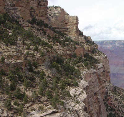
Toroweap Formation (slopes and cliffs) crops out between massive cliffs the Kaibab Formation (above) and Coconino Sandstone (below) on Grand Canyon's South Rim.
Permian, Early*
Leonardian, late*
Late Early Permian - 273 million years
(age used by National Park Service;
Mathis and Bowman, 2005)
Plateau sedimentary province*
Great Basin province*
Paradox basin
Wasatch uplift*
AZ(n)*
NV(se)*
UT(s)*
Type section: on east wall of Toroweap Valley, Grand Canyon National Monument, about 9 mi above mouth and 8 mi north of Colorado River, Mohave Co., AZ (McKee, 1938). Reference section designated in sec. 12, T. 33 N., R. 9 W., east to top of Hurricane Cliffs, Mohave Co., AZ (Sorauf and Billingsley, 1991).
(alphabetical): Brady Canyon Member (AZ*,NV*), Seligman Member (AZ*), Woods Ranch Member (AZ*,NV*).
Named (McKee, 1938). Assigned to Kaibab Group (Welsh and others, 1979). Revised, removed from Aubrey Group (abandoned) (McKee, 1982). Revised (Blakey, 1990). Seligman, Brady Canyon, and Woods Ranch members described; Reference (Sorauf and Billingsley, 1991). Areal limits (Anderson and Hintze, 1993; Sprinkel, 1994).
Toroweap Formation (Lower Permian), undivided—Includes, in descending order, Woods Ranch, Brady Canyon, and Seligman Members, undivided, as defined by Sorauf and Billingsley (1991)
Woods Ranch Member—Gray and light-red, slope-forming gypsifereous siltstone and silty sandstone, interbedded with white laminated gypsum and gray thinbedded limestone. Gypsum beds are as much as 10 ft (3 m) thick. Unit as a whole weathers reddish gray. Bedding locally distorted due to solutioning of gypsum. Contact with underlying Brady Canyon Member is gradational and arbitrarily marked at top of cliff-forming limestone of the Brady Canyon. Variable thickness owing to solution of gypsum and channel erosion in upper part; averages about 65 ft (20 m) thick in southeastern quarter of map area, thickening to as much as 200 ft (60 m) in northwestern half of map area.
Brady Canyon Member—Gray, cliff-forming, thin- to medium-bedded [1–5 ft (0.05– 1.4 m)], fine- to coarse-grained, fetid, fossiliferous limestone. Weathers dark gray. Includes thin-bedded dolomite in upper and lower parts. Contains white and gray chert nodules that make up less than 8 percent of unit. Contact with underlying Seligman Member is gradational and arbitrarily placed at base of cliffforming limestone of the Brady Canyon. Thickness about 40 ft (12 m) at eastern edge of map area, increasing to about 130 ft (40 m) at western edge of map area.
Seligman Member—Gray, light-purple, and yellowish-red, slope-forming, thin-bedded dolomite, sandstone, and gypsum above intertongued Coconino Sandstone, and yellowish-tan, flat-bedded, thin-bedded sandstone below the Coconino. In eastern two-thirds of map area, unit is mostly a purplish to light-red, flat-bedded calcareous sandstone interbedded with gray, thin-bedded limestone. In western third of map area, unit is gray-white gypsum and light-red to yellowish-red, thinbedded calcareous sandstone and gray dolomite. Forms slope or recess between overlying cliff-forming Brady Canyon Member and underlying cliff-forming Coconino Sandstone (Pc) in southeastern two-thirds of map area; forms a gypsifereous slope similar to that of Woods Ranch Member in northwestern third of map area. Sharp gradational contact with the interbedded Coconino where crossbedded sand dunes of the Coconino were beveled off and sand was redistributed as flat-bedded sandstone. The Coconino intertongues with lower part of the Seligman in western third of map area (Fisher, 1961; Schleh, 1966; Rawson and Turner, 1974; and Billingsley and Workman, 2000). Thickness about 30 ft (9 m) in eastern half of map area, increasing to about 55 ft (17 m) in western half.
References
McKee, E.D., 1938, The environment and history of the Toroweap and Kaibab
formations of northern Arizona and southern Utah: Carnegie Institution
of Washington Publication, no. 492.
Fisher, W., 1961, Upper Paleozoic and lower Mesozoic stratigraphy of Parashant and Andrus Canyons, Mohave County, northwestern Arizona: Lawrence, Kans., University of Kansas Ph. D. thesis, 345 p.
Schleh, E.E., 1966, Stratigraphic section of Toroweap and Kaibab formations in Parashant Canyon , Arizona : Arizona Geological Society Digest, v. 8, p. 57-64.
Rawson, R.R., and Turner, C.E., 1974, The Toroweap Formation-A new look, in Karlstrom, T.N.V., Swann, G.A., and Eastwood, R.L., editors, Geology of northern Arizona with notes on archaeology and paleoclimate; Part 1, Regional studies: Geological Society of America, Rocky Mountain Section Meeting, Flagstaff, Ariz., p. 155-190.
Welsh, J.E., Stokes, W.L. and Wardlaw, B.R., 1979, Regional stratigraphic relationships of the Permian "Kaibab" or Black Box Dolomite of the Emery high, central Utah, IN Baars, D.L., ed., Permianland: Four Corners Geological Society Field Conference Guidebook, 9th Field Conference, Moab, UT, September 27-30, 1979, p. 143-149.
McKee, E.D. (editor), 1982, The Supai Group of Grand Canyon: U.S. Geological Survey Professional Paper, 1173, 504 p.
Blakey, R.C., 1990, Stratigraphy and geologic history of Pennsylvanian and Permian rocks, Mogollon Rim region, central Arizona and vicinity: Geological Society of America Bulletin, v. 102, no. 9, p. 1189-1217.
Turner, C. E., 1990, Toroweap Formation. In: Beus, S.S., Morales, M. (eds), Grand Canyon Geology, Oxford University Press, New York, p. 203-223.
Sorauf, J.E. and Billingsley, G.H., 1991, Members of the Toroweap and Kaibab Formations, Lower Permian, northern Arizona and southwestern Utah: The Mountain Geologist, v. 28, no. 1, p. 9-24.
Anderson, R.E. and Hintze, L.F., 1993, Geologic map of the Dodge Spring quadrangle, Washington County, Utah and Lincoln County, Nevada: U.S. Geological Survey Geologic Quadrangle Map, GQ-1721, 1 sheet, scale 1:24,000.
Sprinkel, D.A., 1994, Stratigraphic and time-stratigraphic cross sections; a north-south transect from near the Uinta Mountain axis across the Basin and Range transition zone to the western margin of the San Rafael Swell, Utah: U.S. Geological Survey Miscellaneous Investigations Series Map, I-2184-D, 31 p., 2 sheets.
McColloch, Miriam E., Gilmour, Ernest H., Snyder, Edward M., 1994, The
order Fenestrata (Bryozoa) of the Toroweap Formation (Permian), southern
Nevada: Journal of Paleontology, v. 68, no. 4, pp. 746-762.
Billingsley, G.H., and Workman, J.B., 2000, Geologic map of the Littlefield 30 ' × 60 ' quadrangle, Mohave County , northwestern Arizona : U.S. Geological Survey Geologic Investigations Series I-2628, scale 1:100,000, pamphlet 25 p.
Billingsley, George H., 2000, Geologic Map of the Grand Canyon 30' by 60' Quadrangle, Coconino and Mohave Counties, Northwestern Arizona: U.S. Geological Survey Geologic Investigation Series I-2688, Available on-line at: http://pubs.usgs.gov/imap/i-2688/.).
Mathis, A. and Bowman, C., 2005, What's in a number? Numeric ages for rocks exposed within the Grand Canyon, Part 2: Nature Notes ( Grand Canyon National Park ), v. 21, no. 2, p. 1-5.