Temple Butte Limestone
Temple Butte Limestone*
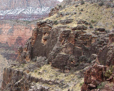 Cliff of Temple Butte Formation exposed along Grand Canyon's South Kaibab Trail.
Devonian, late Middle?*
Devonian, early Late*
Middle to Late Devonian - 385 million years (age used by National Park Service; Mathis and Bowman, 2005)
Plateau sedimentary province*
Black Mesa basin*
AZ(ne)*
Not compiled to date.
Areal limits (Ulrich, 1984).
Temple Butte Formation (Upper and Middle Devonian)—Purple, reddish-purple, darkgray, and light-gray, ledge-forming dolomite, sandy dolomite, sandstone, mudstone, and limestone as defined by Beus (1990). Purple, reddish-purple, and lightgray, fine- to coarse-grained, thin- to medium-bedded, ripple-laminated ledges of mudstone, sandstone, dolomite, and conglomerate fill channels eroded into the underlying Cambrian strata; channels are as much as 100 ft (30 m) deep in eastern half of map area, and about 40 ft (12 m) deep in western half of map area. Channel deposits are overlain by dark-gray to olive-gray, medium- to thick-bedded dolomite, sandy dolomite, limestone, and sandstone. Unit as a whole forms sequence of dark-gray ledges. Unconformity at base of unit represents major stratigraphic break in Paleozoic rock record in the Grand Canyon, spanning part of Late Cambrian, all of Ordovician and Silurian, and most of Early and Middle Devonian time, about 100 million years. Dark-gray Devonian rocks are distinguished from underlying light-gray Cambrian rocks by color contrast. Unit thickens from about 50 ft (15 m) in eastern half of map area to as much as 275 ft (84 m) in western half of map area, excluding local channel deposit thickness.
Ulrich, G.E. (compiler), Billingsley, G.H. (compiler), Hereford, Richard (compiler), Wolfe, E.W. (compiler), Nealey, L.D. (compiler) and Sutton, R.L. (compiler), 1984, Maps showing geology, structure, and uranium deposits of the Flagstaff 1 degrees by 2 degrees quadrangle, Arizona: U.S. Geological Survey Miscellaneous Investigations Series Map, I-1446, 2 sheets, scale 1:250,000.
Beus, S.S., 1990, Temple Butte Formation. In: Beus, S.S., Morales, M.,
editors, Grand Canyon Geology, Oxford University Press, New York, p. 107-117.
Billingsley, George H., 2000, Geologic Map of the Grand Canyon 30' by 60' Quadrangle, Coconino and Mohave Counties, Northwestern Arizona: U.S. Geological Survey Geologic Investigation Series I-2688, Available on-line at: http://pubs.usgs.gov/imap/i-2688/.).
Mathis, A. and Bowman, C., 2005, What's in a number? Numeric ages for rocks exposed within the Grand Canyon, Part 2: Nature Notes ( Grand Canyon National Park ), v. 21, no. 2, p. 1-5.