Redwall Limestone
Redwall Limestone (AZ*,NM*,UT*)
Redwall Marble (CA*)
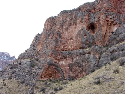
Redwall Limestone cliffs along Grand Canyon's South Kaibab Trail.
Mississippian, Early*
Kinderhookian*
Osagean*
Mississippian, Late*
Meramecian*
Late Early-Middle Mississippian -
340 million years (age used by National Park Service; Mathis and Bowman, 2005)
Great Basin province*
Plateau sedimentary province*
Basin and Range province*
Salton basin*
Black Mesa basin*
Areal Extent:
AZ(n)*
CA(se)*
NM*
UT(s)*
Type Locality:
Shinumo drainage basin, on north side of Grand Canyon. Named for red appearance of its escarpment on either side of the Grand Canyon (Gilbert, 1875) [Geologic names lexicons, USGS Bull. 896, 1200].
Subunits:
(alphabetical): Anchor Member (UT), Arrowhead Member (UT), Bullion Member (UT), Dawn Dolomite Member (UT), Horseshoe Mesa Member (AZ*,UT*), Mooney Falls Member (AZ*,UT*), Thunder Springs Member (AZ*,UT*), Whitmore Wash Member (AZ*,UT*), Yellowpine Member (UT).
Unit Name History:
Named (G.K. Gilbert, 1875, US Geol. and Geog. Survey W. 100th Meridian, v. 3, p. 162, 177-186, 197, figs. 81, 82) [Geologic names lexicons, USGS Bull. 896, 1200]. Revised; Overview (Darton, 1910). Revised (Noble, 1914, 1923). Revised; Areal limits (Crosby, 1959). Areal limits (Baer, 1962; Peterson and Barnum, 1973). Revised (McKee, 1975). Redescribed; Revised; Areal limits (Hamilton, 1982). Areal limits (Steven and Morris, 1983). Revised (Billingsley and Beus, 1985). Areal limits; Overview (Armstrong and Holcomb, 1989).
Redwall Limestone (Upper and Lower Mississippian), undivided—Includes, in descending order, Horseshoe Mesa, Mooney Falls, Thunder Springs, and Whitmore Wash Members as defined by McKee (1963) and McKee and Gutschick (1969).
Horseshoe Mesa Member—Light-olive-gray, ledge- and cliff-forming, thin-bedded, fine-grained limestone. Weathers to receding ledges. Gradational and disconformable contact with underlying massive-bedded limestone of Mooney Falls Member marked by thin-bedded, platy limestone beds of the Horseshoe Mesa that form recess about 3–9 ft (1–3 m) thick near top of cliff formed by the Mooney
Falls. Fossils are locally common. Includes distinctive ripple-laminated limestone and oolitic limestone beds and some chert lenses. Member thickens slightly from east to west across map area; locally absent where removed by Late Mississippian paleovalley erosion. Thickness 50–100 ft (15–30 m).
Mooney Falls Member—Light-gray, cliff-forming, fine- to coarse-grained, thick-bedded to very thick bedded [4–20 ft (1–6 m)], fossiliferous limestone. Limestone weathers dark gray; chert beds weather black. Includes dark-gray dolomite beds in lower part in western quarter of map area; oolitic limestone and chert beds restricted to upper part throughout map area. Contains large-scale, tabular and planar, low-angle cross-stratified limestone beds in upper third of unit in western half of map area. Disconformable contact with the underlying Thunder Springs distinguished by lithology; massive-bedded, gray limestone of the Mooney Falls overlies thin-bedded, dark-gray to brown dolomite and white chert beds of the Thunder Springs. Member thickens from about 250 ft (75 m) in southeast quarter of map area to about 400 ft (122 m) in northwest quarter.
Thunder Springs Member—About half of member is gray, cliff-forming, fossiliferous, thin-bedded limestone and about half is brownish-gray, cliff-forming, thin-bedded [1–5 in. (2–12 cm)], finely crystalline dolomite and fine- to coarse-grained limestone interbedded with white beds of chert lenses. Limestone is common in northern half of map area, dolomite is more common in southern half. Weathers
into distinctive prominent band of black and light-brown bands on cliff face. Locally includes large-scale cross-bedding and irregularly folded beds in northern half of map area. Fossil content increases from east to west across map area. Disconformable planar contact with underlying Whitmore Wash Member distinguished by distinct lack of chert in the Whitmore Wash. Member is about 100 ft (30 m) thick in south half of map area, increasing to about 150 ft (45 m) thick in north half.
Whitmore Wash Member—Yellowish-gray and brownish-gray, cliff-forming, thickbedded, fine-grained dolomite. Weathers dark gray. Fossiliferous in northwestern quarter of map area. Unit is mostly limestone in western and northern part of map area. Unconformable contact with underlying Temple Butte Formation (Dtb) marked by erosion channels of low relief about 5–10 ft (2–3 m) in depth.
Contact generally recognized where major cliff of the Redwall overlies stair-step ledges of the Temple Butte. Uniform thickness throughout map area, about 80 ft (25 m).
Darton, N.H., 1910, A reconnaissance of parts of northwestern New Mexico and northern Arizona: U.S. Geological Survey Bulletin, 435, 88 p., (incl. geologic map, scale 1:1,000,000).
Noble, L.F., 1914, The Shinumo quadrangle, Grand Canyon district, Arizona: U.S. Geological Survey Bulletin, 549, 100 p., (incl. geologic map, scale 1:48,000).
Noble, L.F., 1923, A section of the Paleozoic formations of the Grand Canyon at the Bass Trail, IN Shorter contributions to general geology, 1922: U.S. Geological Survey Professional Paper, 131-B, p. B23-B73.
Crosby, G.W., 1959, Geology of the South Pavant Range, Millard and Sevier Counties, Utah: Brigham Young University Geology Studies, v. 6, no. 3, 59 p., (incl. geologic map, scale 1:55,000).
Baer, J.L., 1962, Geology of the Star Range, Beaver County, Utah: Brigham Young University Geology Studies, v. 9, pt. 2, p. 29-52.
McKee, E.D., 1963, Nomenclature for lithologic subdivisions of the Redwall Limestone , Arizona : U.S. Geological Survey Professional Paper 475-C, p. 21-22.
Peterson, Fred and Barnum, B.E., 1973, Geologic map and coal resources of the northeast quarter of the Cummings Mesa quadrangle, Kane County, Utah: U.S. Geological Survey Coal Investigations Map, C-63, 2 sheets, scale 1:24,000.
McKee, E.D., and Gutschick, R.C., 1969, History of the Redwall Limestone of northern Arizona : Geological Society of America Memoir, v. 114, 726 p.
McKee, E.D., 1975, The Supai Group; subdivision and nomenclature, IN Contributions to stratigraphy: U.S. Geological Survey Bulletin, 1395-J, p. J1-J7.
Hamilton, Warren, 1982, Structural evolution of the Big Maria Mountains, northeastern Riverside County, southeastern California, IN Frost, E.G., and Martin, D.L., editors, Mesozoic-Cenozoic tectonic evolution of the Colorado River region, California, Arizona, and Nevada; Anderson-Hamilton volume: San Diego, CA, Cordilleran Publishers, p. 1-27, Published in conjunction with the Geological Society of America symposium and field trip, April, 1982.
Steven, T.A. and Morris, H.T., 1983, Geologic map of the Cove Fort quadrangle, west-central Utah: U.S. Geological Survey Miscellaneous Investigations Series Map, I-1481, 1 sheet, scale 1:50,000.
Billingsley, G.H. and Beus, S.S., 1985, The Surprise Canyon Formation; an Upper Mississippian and Lower Pennsylvanian(?) rock unit in the Grand Canyon, Arizona, IN Stratigraphic notes, 1984: U.S. Geological Survey Bulletin, 1605-A, p. A27-A33.
Armstrong, A.K. and Holcomb, L.D., 1989, Stratigraphy, facies and paleotectonic history of Mississippian rocks in the San Juan basin of northwestern New Mexico and adjacent areas, IN Evolution of sedimentary basins, San Juan basin: U.S. Geological Survey Bulletin, 1808-D, p. D1-D21.
Beus, S.S., 1990, Redwall Limestone And Surprise Canyon Formation. In:
Beus, S.S., Morales, M., editors, Grand Canyon Geology, Oxford University
Press, New York, p. 119-145.
Billingsley, George H., 2000, Geologic Map of the Grand Canyon 30' by 60' Quadrangle, Coconino and Mohave Counties, Northwestern Arizona: U.S. Geological Survey Geologic Investigation Series I-2688, Available on-line at: http://pubs.usgs.gov/imap/i-2688/.).
Mathis, A. and Bowman, C., 2005, What's in a number? Numeric ages for rocks exposed within the Grand Canyon, Part 2: Nature Notes ( Grand Canyon National Park ), v. 21, no. 2, p. 1-5.