Muddy Creek Formation
Muddy Creek Formation (AZ*,CA*,NV*,UT*)
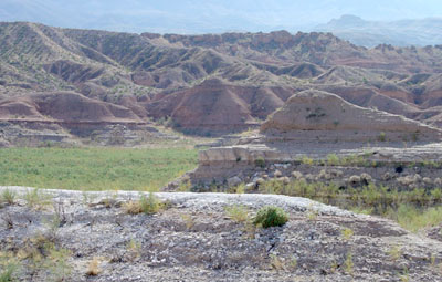
Badlands in the Muddy Creek Formation near the eastern end of Lake Mead National Recreation Area.
Tertiary*
Miocene*
Pliocene*
Great Basin province*
Plateau sedimentary province*
AZ(nw)*
CA*
NV(s)*
UT(sw)*
Not designated. Named for Muddy Creek, Clark Co., NV (Longwell, 1928).
(alphabetical): Fortification Basalt Member (AZ*,NV*), Hualapai Limestone Member (AZ).
Name credited to C. Stock, 1921, GSA Bull., v. 32, p. 147 [abs]. First published use in a comprehensive report (Longwell, 1928). Overview; Revised, Fortification Basalt Member named (Longwell, 1963). Areal limits; Lower contact revised (Moore, 1972). Isotopic dating; Revised, Hualapai Formation reduced in rank and assigned as upper member of Muddy Creek (Blair, 1978). Overview; Areal limits (Bohannon, 1984). Isotopic dating (Hintze, 1986). Overview; Isotopic dating (Hintze and others, 1994). Mapped 1:24k; Overview (Williams and others, 1997).
References
Longwell, C.R., 1928, Geology of the Muddy Mountains, Nevada, with a section through the Virgin Range to the Grand Wash Cliffs, Arizona: U.S. Geological Survey Bulletin, 798, 152 p., (incl. geologic map, scale 1:250,000).
Longwell, C.R., 1963, Reconnaissance geology between Lake Mead and Davis dam, Arizona-Nevada, IN Shorter contributions to general geology, 1960-1964: U.S. Geological Survey Professional Paper, 374-E, p. E1-E51, (incl. geologic map, scale 1:125,000).
Moore, R.T., 1972, Geology of the Virgin and Beaverdam Mountains, Arizona: Arizona Bureau of Mines Bulletin, no. 186, 65 p., (incl. geologic map, scale 1:62,500).
Blair, W.N., 1978, Gulf of California in Lake Mead area of Arizona and Nevada during late Miocene time: American Association of Petroleum Geologists Bulletin, v. 62, no. 7, p. 1159-1170.
Bohannon, R.G., 1984, Nonmarine sedimentary rocks of Tertiary age in the Lake Mead region, southeastern Nevada and northwestern Arizona: U.S. Geological Survey Professional Paper, 1259, 72 p., (incl. geologic map, scale approx. 1:790,000).
Hintze, L.H., 1986, Stratigraphy and structure of the Beaver Dam Mountains, southwestern Utah, IN Thrusting and extensional structures and mineralization in the Beaver Dam Mountains, southwestern Utah: Utah Geological Association Publication, no. 15, p. 1-36.
Hintze, L.F., Anderson, R.E. and Embree, G.F., 1994, Geologic map of the Motoqua and Gunlock quadrangles, Washington County, Utah: U.S. Geological Survey Miscellaneous Investigations Series Map, I-2427, 7 p., 1 sheet, scale 1:24,000.
Williams, V.S., Bohannon, R.G. and Hoover, D.L., 1997, Geologic map of the Riverside quadrangle, Clark County, Nevada: U.S. Geological Survey Geologic Quadrangle Map, GQ-1770, 1 sheet, scale 1:24,000