Morrison Formation
Morrison Formation (AZ*,CO*,KS,MT*,NE,NM*,ND*,OK*,SD*,TX,UT*,WY*)
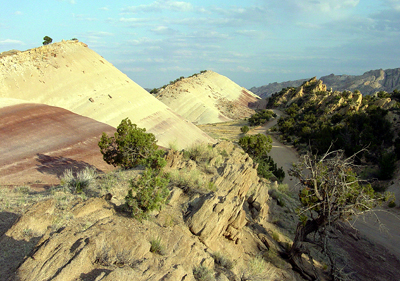
Outcrops of Morrision Formation along the Notom-Bullfrog Road in southern Capitol Reef National Park.
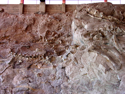
Dinosaur bones in the Morrison Formation on display at Dinosaur National Monument.
Jurassic, Late*
Oxfordian, late*
Kimmeridgian*
Tithonian*
Cretaceous, Early (local)
Neocomian (local)
Barremian (local)
Aptian (local)
Albian (local)
Anadarko basin*
Big Horn basin*
Black Mesa basin*
Central Montana uplift*
Chadron arch*
Denver basin*
Green River basin*
Las Vegas-Raton basin*
Montana folded belt province*
North Park basin*
Orogrande basin
Palo Duro basin*
Paradox basin*
Piceance basin*
Plateau sedimentary province*
Powder River basin*
San Juan basin*
San Luis basin*
Sierra Grande uplift*
Sweetgrass arch*
Uinta basin*
Wasatch uplift*
Williston basin*
AZ*
CO*
KS
MT*
NE
NM*
ND*
OK*
SD*
TX
UT*
WY*
Not designated. Named for exposures near town of Morrison, Jefferson Co., CO (Eldridge, 1896).
Type section/locality designated along north side of W. Alameda Parkway roadcut, 2 mi north of town of Morrison, in SE/4 sec. 23, T. 4 S., R. 40 W., Jefferson Co., CO (Waldschmidt and LeRoy, 1944).
(alphabetical): Casamero Member (NM), Bluff Sandstone Member (AZ*,CO,NM*,UT*), Brushy Basin Member (AZ*,CO*,NM*,UT*), Bullington Member (NM), Chavez Member (UT*), Fiftymile Member (UT*), Jackpile Sandstone Member (NM*), Prewitt Sandstone Member (NM), Recapture Member (AZ*,CO*,NM*,UT*), Salt Wash Member (AZ*,CO*,NM*,UT*), Stockett Bed (MT), Tidwell Member (AZ*,CO*,NM*,UT*), Unkpapa Sandstone Member (SD*), Westwater Canyon Member (AZ*,CO*,NM*,UT*).
Unit Name History:
Named (Eldridge, 1896). Revised (Darton, 1904). Age modified (Darton and
Paige, 1925). Revised (Burbank, 1930; Goldman and Spencer, 1941). Type
section/locality designated (Waldschmidt and LeRoy, 1944). Revised (Cobban,
1945; LeRoy, 1946; Imlay, 1947; Stokes and Phoenix, 1948; Eckel, 1949;
Harshbarger and others, 1951; Smith, 1954; McLaughlin, 1954; Freeman and
Hilpert, 1957). Mapped 1:24k, Jefferson Co, CO (Van Horn, 1957). Biostratigraphic
dating (Peck, 1957). Revised (Ekren and Houser, 1959; Moberly, 1960; Mirsky,
1962). Mapped 1:24k, Jefferson Co, CO (Scott, 1962). Mapped 1:24k, Douglas
Co, Jefferson Co, CO (Scott, 1963). Revised (Smith, 1967). Mapped 1:24k,
Jefferson Co, CO (Scott, 1972). Mapped 1:24k, Ouray Co, CO (Luedke, 1972).
Mapped 1:24k, Grand Co, CO (Taylor, 1975). Mapped 1:24k, Moffat Co, CO
(Rowley and Hansen, 1979). Revised (O'Sullivan, 1980, 1983, 1984; Szigeti
and Fox, 1981; Mudge and Rice, 1982; Owen and others, 1984). Age modified
locally (Kowallis and Heaton, 1984). Not used (Witkind and others, 1986).
Age modified; Isotopic dating (Kowallis and Heaton, 1987). Not used (Schwans,
1988; Weiss and Roche, 1988). Revised (Aubrey, 1988; Condon and Huffman,
1988; Peterson, 1988; Condon, 1989; Lucas, 1991). Isotopic dating (Kowallis
and others, 1991). Age modified locally (Aubrey, 1992). Revised (O'Sullivan,
1992; Peterson, 1994). Biostratigraphic dating; Isotopic dating (Litwin
and others, in press).
Publications providing an Overview and/or Areal limits: Lee, 1902; Smith,
1903; Darton, 1904, 1909; Gilluly and Reeside, Jr., 1928; Gregory and
Moore, 1931; Goldman and Spencer, 1941; Waldschmidt and LeRoy, 1944; Speiker,
1946; Imlay, 1952; Waage, 1955; Tank, 1956; Frederickson and others, 1956;
Harshbarger and others, 1957; Sohn, 1958; Waage, 1959; Baldwin and Muelberger,
1959; Sohn and Peck, 1963; Robinson and Barnett, 1963; Mapel and Chisholm,
1964; Robinson and others, 1964; Pipiringos and O'Sullivan, 1976; Szigeti
and Fox, 1981; Barnes, 1983; DeWitt and others, 1986; Hunt and Lucas,
1987; GNU staff remark, 1989a, 1989b; Robertson, 1990; Johnson and Johnson,
1991; Condon, 1992; Aubrey, 1992; Fox, 1993.
References
Eldridge, G.H., 1896, Mesozoic geology, IN Geology of the Denver basin in Colorado: U.S. Geological Survey Monograph, 27, p. 51-151.
Lee, W.T., 1902, The Morrison shales of southern Colorado and northern New Mexico: Journal of Geology, v. 10, p. 36-58.
Smith, W.S.T., 1903, Description of the Hartville quadrangle [Wyoming]: U.S. Geological Survey Geologic Atlas of the United States, Hartville folio, no. 91, 6 p.
Darton, N.H., 1904, Comparison of the stratigraphy of the Black Hills, Bighorn Mountains, and Rocky Mountain Front Range: Geological Society of America Bulletin, v. 15, p. 379-448.
Darton, N.H., 1909, Geology and water resources of the northern portion of the Black Hills and adjoining regions in South Dakota and Wyoming: U.S. Geological Survey Professional Paper, 65, 105 p.
Darton, N.H. and Paige, Sidney, 1925, Description of the central Black Hills [South Dakota], [includes contributions by J.D. Irving]: U.S. Geological Survey Geologic Atlas of the United States, Central Black Hills folio, no. 219, 34 p.
Gilluly, James and Reeside, J.B., Jr., 1928, Sedimentary rocks of the San Rafael Swell and some adjacent areas in eastern Utah, IN Shorter contributions to general geology, 1927: U.S. Geological Survey Professional Paper, 150-D, p. D61-D110.
Burbank, W.S., 1930, Revision of geologic structure and stratigraphy in the Ouray district of Colorado, and its bearing on ore deposition: Colorado Scientific Society Proceedings, v. 12, no. 6, p. 151-232.
Gregory, H.E. and Moore, R.C., 1931, The Kaiparowits region, a geographic and geologic reconnaissance of parts of Utah and Arizona: U.S. Geological Survey Professional Paper, 164, 161 p.
Goldman, M.I. and Spencer, A.C., 1941, Correlation of Cross' La Plata sandstone, southwestern Colorado: American Association of Petroleum Geologists Bulletin, v. 25, no. 9, p. 1745-1767.
Waldschmidt, W.A. and LeRoy, L.W., 1944, Reconsideration of the Morrison formation in the type area, Jefferson County, Colorado: Geological Society of America Bulletin, v. 55, no. 9, p. 1097-1114.
Cobban, W.A., 1945, Marine Jurassic formations of the Sweetgrass arch, Montana: American Association of Petroleum Geologists Bulletin, v. 29, no. 9, p. 1262-1303.
Spieker, E.M., 1946, Late Mesozoic and early Cenozoic history of central Utah, IN Shorter contributions to general geology, 1943-45: U.S. Geological Survey Professional Paper, 205-D, p. D117-D161.
LeRoy, L.W., 1946, Stratigraphy of the Golden-Morrison area, Jefferson County, Colorado: Colorado School of Mines Quarterly, v. 41, no. 2.
Imlay, R.W., 1947, Marine Jurassic of Black Hills area, South Dakota and Wyoming: American Association of Petroleum Geologists Bulletin, v. 31, no. 2, p. 227-273.
Stokes, W.L. and Phoenix, D.A., 1948, Geology of the Egnar-Gypsum Valley area, San Miguel and Montrose Counties, Colorado: U.S. Geological Survey Oil and Gas Investigations Map, OM-93, 1 sheet, scale 1:48,000.
Eckel, E.B., 1949, Geology and ore deposits of the La Plata district, Colorado: U.S. Geological Survey Professional Paper, 219, 179 p.
Harshbarger, J.W., Repenning, C.A. and Jackson, R.L., 1951, Jurassic stratigraphy of the Navajo country, IN Smith, C.T., and Silver, Caswell, editors, Guidebook of the San Juan basin [covering south and west sides], New Mexico and Arizona: New Mexico Geological Society Guidebook, no. 2, p. 95-99, 103.
Imlay, R.W., 1952, Correlation of the Jurassic formations of North America, exclusive of Canada: Geological Society of America Bulletin, v. 63, no. 9, p. 953-992.
McLaughlin, T.G., 1954, Geology and ground-water resources of Baca County, Colorado: U.S. Geological Survey Water-Supply Paper, 1256, 232 p.
Smith, C.T., 1954, Geology of the Thoreau quadrangle, McKinley and Valencia Counties, New Mexico: New Mexico Bureau of Mines and Mineral Resources Bulletin, no. 31, 36 p.
Waage, K.M., 1955, Dakota group in northern Front Range foothills, Colorado, IN Shorter contributions to general geology, 1955-57: U.S. Geological Survey Professional Paper, 274-B, p. B15-B51.
Frederickson, E.A., De Lay, M. and Saylor, W.W., 1956, Ralston Formation of Canon City embayment, Colorado: American Association of Petroleum Geologists Bulletin, v. 40, no. 9, p. 2120-2148.
Tank, R.W., 1956, Clay mineralogy of Morrison formation, Black Hills area, Wyoming and South Dakota: American Association of Petroleum Geologists Bulletin, v. 40, no. 5, p. 871-878.
Harshbarger, J.W., Repenning, C.A. and Irwin, J.H., 1957, Stratigraphy of the uppermost Triassic and the Jurassic rocks of the Navajo country: U.S. Geological Survey Professional Paper, 291, 74 p.
Van Horn, Richard, 1957, Bedrock geology of the Golden quadrangle, Colorado: U.S. Geological Survey Geologic Quadrangle Map, GQ-103, 1 sheet, scale 1:24,000.
Freeman, V.L. and Hilpert, L.S., 1957, Stratigraphy of the Morrison formation in part of northwestern New Mexico, IN Contributions to the geology of uranium, 1955: U.S. Geological Survey Bulletin, 1030-J, p. J309-J334.
Peck, R.E., 1957, North American Mesozoic Charophyta, IN Shorter contributions to general geology, 1956: U.S. Geological Survey Professional Paper, 294-A, p. A1-A44.
Sohn, I.G., 1958, Middle Mesozoic non-marine ostracods of the Black Hills, IN Bibb, T.W., Jr., chairman, Powder River basin: Wyoming Geological Association Field Conference Guidebook, no. 13, p. 120-126.
Ekren, E.B. and Houser, F.N., 1959, Relations of Lower Cretaceous and Upper Jurassic rocks, Four Corners area, Colorado: American Association of Petroleum Geologists Bulletin, v. 43, no. 1, p. 190-201.
Waage, K.M., 1959, Stratigraphy of the Inyan Kara group in the Black Hills, IN Contributions to general geology, 1958: U.S. Geological Survey Bulletin, 1081-B, p. B11-B90.
Baldwin, Brewster and Muehlberger, W.R., 1959, Geologic studies of Union County, New Mexico: New Mexico Bureau of Mines and Mineral Resources Bulletin, no. 63, 171 p.
Moberly, R., Jr., 1960, Morrison, Cloverly, and Sykes Mountain formations, northern Bighorn basin, Wyoming and Montana: Geological Society of America Bulletin, v. 71, no. 8, p. 1137-1176.
Mirsky, A., 1962, Stratigraphy of non-marine Upper Jurassic and Lower Cretaceous rocks, southern Big Horn Mountains, Wyoming: American Association of Petroleum Geologists Bulletin, v. 46, no. 9, p. 1653-1680.
Scott, G.R., 1962, Geology of the Littleton quadrangle, Jefferson, Douglas, and Arapahoe Counties, Colorado, IN Contributions to general geology, 1960: U.S. Geological Survey Bulletin, 1121-L, p. L1-L53.
Robinson, G.D. and Barnett, H.F., 1963, Geology of the Three Forks quadrangle, Montana, with sections on petrography of igneous rocks by H.F. Barnett: U.S. Geological Survey Professional Paper, 370, 143 p.
Sohn, I.G. and Peck, R.E., 1963, Theriosynoecum wyomingense (Branson, 1935), a possible guide ostracode to the Salt Wash Member of the Morrison Formation, IN Contributions to general geology, 1962: U.S. Geological Survey Bulletin, 1161-A, p. A1-A10.
Scott, G.R., 1963, Bedrock geology of the Kassler quadrangle, Colorado, IN Geology of the Kassler quadrangle, Jefferson and Douglas Counties, Colorado: U.S. Geological Survey Professional Paper, 421-B, p. B71-B125.
Mapel, W.J. and Chisholm, W.A., 1964, Nonopaque heavy minerals in sandstone of Jurassic and Cretaceous age in the Black Hills, Wyoming and South Dakota, IN Contributions to general geology, 1962: U.S. Geological Survey Bulletin, 1161-C, p. C1-C59.
Robinson, C.S., Mapel, W.J. and Bergendahl, M.H., 1964, Stratigraphy and structure of the northern and western flanks of the Black Hills uplift, Wyoming, Montana, and South Dakota: U.S. Geological Survey Professional Paper, 404, 134 p.
Smith, C.T., 1967, Jurassic stratigraphy of the north flank of the Zuni Mountains, IN Trauger, Fred, ed., Guidebook of Defiance-Zuni-Mt. Taylor region [Arizona and New Mexico]: New Mexico Geological Society Guidebook, no. 18, p. 132-137.
Luedke, R.G., 1972, Geologic map of the Wetterhorn Peak quadrangle, Colorado: U.S. Geological Survey Geologic Quadrangle Map, GQ-1011, 1 sheet, scale 1:24,000.
Scott, G.R., 1972, Geologic map of the Morrison quadrangle, Jefferson County, Colorado: U.S. Geological Survey Miscellaneous Investigations Series Map, I-790-A, 1 sheet, scale 1:24,000.
Taylor, R.B., 1975, Geologic map of the Bottle Pass quadrangle, Grand County, Colorado: U.S. Geological Survey Geologic Quadrangle Map, GQ-1224, 1 sheet, scale 1:24,000.
Pipiringos, G.N. and O'Sullivan, R.B., 1976, Stratigraphic sections of some Triassic and Jurassic rocks from Douglas, Wyoming, to Boulder, Colorado: U.S. Geological Survey Oil and Gas Investigations Chart, OC-69, 1 sheet.
Rowley, P.D. and Hansen, W.R., 1979, Geologic map of the Plug Hat quadrangle, Moffat County, Colorado: U.S. Geological Survey Geologic Quadrangle Map, GQ-1514, 1 sheet, scale 1:24,000.
O'Sullivan, R.B., 1980, Stratigraphic sections of Middle Jurassic San Rafael Group from Wilson arch to Bluff in southeastern Utah: U.S. Geological Survey Oil and Gas Investigations Chart, OC-102, 1 sheet.
Szigeti, G.J. and Fox, J.E., 1981, Unkpapa Sandstone (Jurassic), Black Hills, South Dakota; an eolian facies of the Morrison Formation, IN Ethridge, F.G., and Flores, R.M., editors, Recent and ancient nonmarine depositional environments; models for exploration: Society of Economic Paleontologists and Mineralogists Special Publication, no. 31, Symposium, Casper, WY, June 3-7, 1979, p. 331-349.
Mudge, M.R. and Rice, D.D., 1982, Lower Cretaceous Mount Pablo Formation, northwestern Montana, IN Contributions to stratigraphy: U.S. Geological Survey Bulletin, 1502-D, p. D1-D19.
O'Sullivan, R.B., 1983, Stratigraphic sections of Middle Jurassic San Rafael Group and related rocks from Dewey Bridge, Utah to Uravan, Colorado: U.S. Geological Survey Oil and Gas Investigations Chart, OC-124, 1 sheet.
Barnes, V.E., 1983, Geologic atlas of Texas, Tucumcari Sheet; Henryk Bronislaw Stenzel memorial edition: University of Texas-Austin, Bureau of Economic Geology, 1 sheet, scale 1:250,000.
Kowallis, B.J. and Heaton, J.S., 1984, Fission-track stratigraphy of Upper Jurassic and Lower Cretaceous bentonites from the Morrison and Cedar Mountain Formations of central Utah [abs.]: Geological Society of America Abstracts with Programs, v. 16, no. 6, 97th Annual Meeting, Reno, NV, November 5-8, 1984, p. 565.
O'Sullivan, R.B., 1984, The base of the Upper Jurassic Morrison Formation in east-central Utah: U.S. Geological Survey Bulletin, 1561, 17 p.
Owen, D.E., Walters, L.J., Jr. and Beck, R.G., 1984, The Jackpile Sandstone Member of the Morrison Formation in west-central New Mexico; a formal definition: New Mexico Geology, v. 6, no. 3, p. 45-52.
Witkind, I.J., Standlee, L.A. and Maley, K.F., 1986, Age and correlation of Cretaceous rocks previously assigned to the Morrison(?) Formation, Sanpete-Sevier Valley area, central Utah: U.S. Geological Survey Bulletin, 1584, 9 p.
DeWitt, Ed, Redden, J.A., Wilson, A.E. and Buscher, David, 1986, Mineral resource potential and geology of the Black Hills National Forest, South Dakota and Wyoming, with a section on salable commodities by J.S. Dersch: U.S. Geological Survey Bulletin, 1580, 135 p., (incl. geologic map, scale 1:250,000).
Kowallis, B.J. and Heaton, J.S., 1987, Fission-track dating of bentonites and bentonitic mudstones from the Morrison Formation in central Utah: Geological Society of America, Geology, v. 15, no. 12, p. 1138-1142.
Hunt, A.P. and Lucas, S.G., 1987, Southernmost outcrops of the Morrison Formation in the Carthage area, Socorro County, New Mexico: New Mexico Geology, v. 9, no. 3, p. 58-62.
Weiss, M.P. and Roche, M.G., 1988, The Cedar Mountain Formation (Lower Cretaceous) in the Gunnison Plateau, central Utah, IN Schmidt, C.J., and Perry, W.J., Jr., editors, Interaction of the Rocky Mountain foreland and the Cordilleran thrust belt: Geological Society of America Memoir, 171, p. 557-569.
Schwans, Peter, 1988, Depositional response of Pigeon Creek Formation, Utah, to initial fold-thrust belt deformation in a differentially subsiding foreland basin, IN Schmidt, C.J., and Perry, W.J., Jr., editors, Interaction of the Rocky Mountain foreland and the Cordilleran thrust belt: Geological Society of America Memoir, 171, p. 531-556.
Aubrey, W.M., 1988, The Encinal Canyon Member, a new member of the Upper Cretaceous Dakota Sandstone in the southern and eastern San Juan basin, New Mexico, IN Revisions to stratigraphic nomenclature of Jurassic and Cretaceous rocks of the Colorado Plateau: U.S. Geological Survey Bulletin, 1633-C, p. C57-C69.
Peterson, Fred, 1988, Stratigraphy and nomenclature of Middle and Upper Jurassic rocks, western Colorado Plateau, Utah and Arizona, IN Revisions to stratigraphic nomenclature of Jurassic and Cretaceous rocks of the Colorado Plateau: U.S. Geological Survey Bulletin, 1633-B, p. B13-56.
Condon, S.M. and Huffman, A.C., Jr., 1988, Revisions in nomenclature of Middle Jurassic Wanakah Formation, northwest New Mexico and northeast Arizona, IN Revisions to stratigraphic nomenclature of Jurassic and Cretaceous rocks of the Colorado Plateau: U.S. Geological Survey Bulletin, 1633-A, p. A1-A12.
Condon, S.M., 1989, Revisions of Middle Jurassic nomenclature in southeastern San Juan basin, New Mexico, IN Evolution of sedimentary basins, San Juan basin: U.S. Geological Survey Bulletin, 1808-E, p. E1-E21.
Robertson, J.F., 1990, Geologic map of the Thoreau quadrangle, McKinley County, New Mexico: U.S. Geological Survey Geologic Quadrangle Map, GQ-1675, 1 sheet, scale 1:24,000.
Johnson, S.Y. and Johnson, R.C., 1991, Stratigraphic and time-stratigraphic cross sections of Phanerozoic rocks along line A-A', Uinta and Piceance basin area-Eagle basin, Colorado, to eastern Basin and Range area, Utah, IN Folio of the Uinta and Piceance basin area: U.S. Geological Survey Miscellaneous Investigations Series Map, I-2184-A, 2 sheets, scale 1:500,000, Prepared in cooperation with the Utah Geological and Mineral Survey.
Lucas, S.G., 1991, Triassic stratigraphy, paleontology and correlation, south-central New Mexico, IN Geology of the Sierra Blanca, Sacramento and Capitan Ranges, New Mexico: New Mexico Geological Society Guidebook, no. 42, p. 243-253.
Kowallis, B.J., Christiansen, E.H. and Deino, A.L., 1991, Age of the Brushy Basin Member of the Morrison Formation, Colorado Plateau, western USA: Cretaceous Research, v. 12, p. 483-493.
Condon, S.M., 1992, Geologic framework of pre-Cretaceous rocks in the Southern Ute Indian Reservation and adjacent areas, southwestern Colorado and northwestern New Mexico, IN Geology and mineral resources of the Southern Ute Indian Reservation: U.S. Geological Survey Professional Paper, 1505-A, p. A1-A56.
Aubrey, W.M., 1992, New interpretations of the stratigraphy and sedimentology of uppermost Jurassic to lowermost Upper Cretaceous strata in the San Juan basin of northwestern New Mexico, IN Evolution of sedimentary basins, San Juan basin: U.S. Geological Survey Bulletin, 1808-J, p. J1-J17.
O'Sullivan, R.B., 1992, Correlation of Middle Jurassic and related rocks from Ouray to Black Canyon, western Colorado: U.S. Geological Survey Oil and Gas Investigations Chart, OC-139, 1 sheet.
Fox, J.E., 1993, Stratigraphic cross sections showing electric logs of Upper Cretaceous and older rocks, Powder River basin, southeastern Montana and northeastern Wyoming: U.S. Geological Survey Oil and Gas Investigations Chart, OC-135 to OC-138, 4 sheets, sections A-A' trhough F-F'; G-G' through L-L'; M-M' through R-R'; S-S' through V-V'.
Peterson, Fred, 1994, Sand dunes, sabkhas, streams, and shallow seas; Jurassic paleogeography in the southern part of the Western Interior basin, IN Caputo, M.V., Peterson, J.A., and Franczyk, K.J., editors, Mesozoic systems of the Rocky Mountain Region, USA: Society of Economic Paleontologists and Mineralogists, Rocky Mountain Section, p. 233-272.
Bader, Kenneth, 2003, The local flora and fauna of a site in the upper
Morrison
Formation (Upper Jurassic) of northeastern Wyoming: Journal of Vertebrate
Paleontology, v. 23, no. 3, Supplement, p. 30.
Foster, John R., 2003, Paleoecological analysis of the vertebrate fauna
of the Morrison
Formation (Upper Jurassic), Rocky Mountain region, U.S.A.: New Mexico
Museum of Natural History and Science, Bulletin v. 23, 95 p.
Houck, Karen J., 2001, Sedimentology and stratigraphy of the Morrison
Formation in the
Dinosaur Ridge area near Morrison, Colorado: The Mountain Geologist, v. 38, no. 3, p. 97-110.
Hubert, John F; Panish, Peter T., 2000, Sedimentology and diagenesis of the dinosaur bones exposed at Dinosaur Ridge along Alameda Parkway in the Morrison Formation (Upper Jurassic), Morrison, Colorado: The Mountain Geologist, v. 37, no. 2, p. 73-90.
Engelmann, George F., and Fiorillo, A. R., 2000, The taphonomy and paleoecology of the Upper Jurassic Morrison Formation determined from a field study of fossil localities: GeoResearch Forum, v. 6, p. 533-540
Morgan, Susan K., Lindsay, Bradford W., Williams, Anthony P., 2000, Geology of Escalante State Park, Utah. In, Geology of Utah's parks and monuments: Sprinkel, Douglas A., Chidsey, Thomas C., Jr., and Anderson, Paul B., editors, Utah Geological Association Publication, v. 28, p. 410-420.
Heckert, Andrew B; Lucas, Spencer G; Zeigler, Kate E; Peterson, Ronald
E; Peterson, Rodney E; D'Andrea, N V Dan, 2000, Stratigraphy, taphonomy,
and new discoveries from the Upper
Jurassic (Morrison Formation, Brushy Basin Member) Peterson Quarry, central
New Mexico: New Mexico Museum of Natural History and Science Bulletin, v. 17, p. 51-59.
Bernier, Julie C., and Chan, Marjorie A.,2000, Stratigraphy and sedimentology of the Late Jurassic Tidwell Member, Morrison Formation in southeastern Utah: Geological Society of America, Abstracts with Programs: v. 32, no. 7, p. 226.
Turner, Christine E., and Peterson, Fred, 1999, Biostratigraphy of dinosaurs
in the Upper Jurassic Morrison Formation of the Western Interior, U.S.A.:
In, Vertebrate paleontology in Utah: Gillette, David D., ed., Utah Geological
Survey Miscellaneous Publication v. 99-1,
p. 77-114.
Engelmann, George F., 1999, Stratigraphic and geographic distribution
of fossils in the upper
part of the Upper Jurassic Morrison Formation of the Rocky Mountain region:
In, Vertebrate paleontology in Utah: Gillette, David D., ed., Utah Geological
Survey Miscellaneous Publication v. 99-1, p. 115-120.
Bilbey, Sue Ann, 1999, Taphonomy of the Cleveland-Lloyd Dinosaur Quarry
in the Morrison
Formation, central Utah; a lethal spring-fed pond: In, Vertebrate paleontology
in Utah: Gillette, David D., ed., Utah Geological Survey Miscellaneous
Publication v. 99-1, p. 121-133.
Currie, Brian S., 1998,Upper Jurassic-Lower Cretaceous Morrison and Cedar Mountain formations, NE Utah-NW Colorado; relationships between nonmarine deposition and early Cordilleran foreland-basin development: Journal of Sedimentary Research, v. 68, no. 4, p. 632-652.
Robinson, John W., and McCabe, Peter J., 1998, Evolution of a braided river system; the Salt Wash Member of the Morrison Formation (Jurassic) in southern Utah: SEPM (Society for Sedimentary Geology) Special Publication, v. 59, p. 93-107.
Robinson, John W., and McCabe, Peter J., 1997, Sandstone-body and shale-body dimensions in a braided fluvial system; Salt Wash Sandstone Member (Morrison Formation), Garfield County, Utah: AAPG Bulletin, v. 81, no. 8, p. 1267-1291.
Anderson, Orin J., and Lucas, Spencer G., 1997, The Upper Jurassic Morrison Formation in the Four Corners region. In, Mesozoic geology and paleontology of the Four Corners region: New Mexico Geological Society Guidebook, v. 48, p. 139-155.
Anderson, Orin J., and Lucas, Spencer G., 1995, Major redefinition of Morrison Formation and upper San Rafael Group on the Colorado Plateau: AAPG Bulletin, v. 79, no. 6, p. 914.
Bazard, David R., and Butler, Robert F., 1994, Paleomagnetism of the Brushy Basin Member of the Morrison Formation; implications for Jurassic apparent polar wander: Journal of Geophysical Research, B, Solid Earth and Planets, v. 99, no. 4, p. 6695-6710.