Moenkopi Formation
Moenkopi Formation (AZ*,CA*,CO*,NM*,NV*,UT*)
Moenkopi Group (AZ)
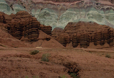
Cliffs of brown Moenkopi Formation crop out in Capitol Reef National Park.
Triassic, Early*
Triassic, Middle?*
Anisian
Paradox basin*
Piceance basin*
Uinta basin*
Plateau sedimentary province*
Black Mesa basin*
San Juan basin*
Green River basin*
Great Basin province*
Palo Duro basin
Las Vegas-Raton basin
Orogrande basin
AZ(n)*
CA(se)*
CO(w)*
NM*
NV*
UT(e)*
Not designated. Named for development at mouth of "Moencopie" Wash, Grand Canyon area, Coconino Co., AZ (Ward, 1901).
"Substitute" type locality: in wall of Little Colorado Canyon, about 5 mi below Tanner Crossing, Coconino Co., AZ (Gregory, 1917).
Formation rank (alphabetical): Ali Baba Member (CO*,UT*), Anton Chico Member (NM), Black Dragon Member (UT), Holbrook Sandstone Member (AZ*), Hoskinnini Member (AZ*,CO*,UT*) or Hoskinnini Tongue (AZ*,CO*,UT*), Moody Canyon Member (UT), Moqui Member (AZ*), Pariott Member (CO*,UT*), Rock Canyon Conglomerate Member (AZ*,NV*,UT*), Sinbad Limestone Member (UT*), Sewemup Member (CO*,UT*), Shnabkaib Member (AZ*,NV*,UT*), Tenderfoot Member (CO*,UT*), Timpoweap Member (AZ,NV,UT*), Torrey Member (UT), Virgin Limestone Member (AZ*,NV*,UT*), Winslow Member (AZ), Wupatki Member (AZ*).
Named (L.F. Ward, 1901, Am. Jour. Sci., 4th, v. 12, p. 401-413) [Geologic names lexicon, USGS Bull. 896]. Overview (Gregory, 1917). Rock Canyon Conglomerate, Virgin Limestone, and Shnabkaib Shale Members named in Great Basin province (Bassler and Reeside, 1921). Salt Creek [later replaced by Wupatki and Moqui Members] and Holbrook Member named in Black Mesa basin (Hager, 1922). Sinbad Limestone Member named in Paradox basin (Gilluly and Reeside, 1928). Timpoweap Member named in Plateau sedimentary province (Gregory, 1948). Wupatki Member first used in Plateau sedimentary province; Age modified to Early and Middle(?) Triassic (McKee, 1951). Contacts revised (Robeck, 1956; Cooley, 1958). Tenderfoot, Ali Baba, Sewemup, and Pariott Members named in Piceance and Uinta basins (Shoemaker and Newman, 1959). Hoskinnini Member assigned in Black Mesa and Paradox basins (Stewart, 1959). Contacts revised (Schell and Yochelson, 1966). Black Dragon, Torrey, and Moody Canyon Members named in Paradox basin and Plateau sedimentary province (Blakey, 1974). Contacts revised (Welsh and others, 1979). Biostratigraphic dating; Age modified to Early and Middle Triassic (Kietzke, 1988). Anton Chico Member assigned in Palo Duro basin; Areal limits (Lucas and Hunt, 1989). Areal limits (Lucas and Hayden, 1991). Overview (Lucas, 1991; Sprinkel, 1994; Hintze and Axen, 1995.
Moenkopi Formation (Lower Triassic)—Red, slope-forming, fine-grained, thin-bedded
shaley siltstone and sandstone. Unit mostly eroded from map area except for
one small outcrop along Bright Angel Fault southwest of Grand Canyon. Only
about 20 ft (6 m) of basal part of Moenkopi Formation is present and most certainly
represents Lower Triassic strata only. Unit is distinguished from underlying
red siltstone of Harrisburg Member of Kaibab Formation (Pk) by its darker red
color and thin-bedded, platy sandstone beds as opposed to the massive-bedded,
pale-red, undulating, softer siltstone beds of Harrisburg Member. A complete section
of the Moenkopi crops out at the Vermilion Cliffs about 24 mi (38 km) northeast
of map area, and at Mount Logan in the Sawmill Mountains about 13 mi (21
km) west of map area. About 20 ft (6 m) exposed.
References
Ward, L.F., 1901, Geology of the Little Colorado Valley: American Journal of Science, 4th series, v. 12, no. 72, p. 401-413.
Darton, N.H., 1910, A reconnaissance of parts of northwestern New Mexico and northern Arizona: U.S. Geological Survey Bulletin, 435, 88 p., (incl. geologic map, scale 1:1,000,000).
Woodruff, E.G., 1912, Geology of the San Juan oil field, Utah, IN Contributions to economic geology, 1910; Part 2, Mineral fuels: U.S. Geological Survey Bulletin, 471-A, p. 76-104.
Gregory, H.E. and Stone, R.W., 1917, Geology of the Navajo country; a
reconnaissance of parts of Arizona, New Mexico, and Utah: U.S. Geological
Survey Professional Paper, 93, 161
p.
Bassler, Harvey and Reeside, J.B., Jr., 1921, Oil prospects in Washington County, Utah, IN Contributions to economic geology, 1921; Part 2, Mineral fuels: U.S. Geological Survey Bulletin, 726-C, p. C87-C107.
Hager, Dorsey, 1922, Oil possibilities of the Holbrook area in northeast Arizona: Mining and Oil Bulletin, v. 8, no. 2, p. 71-74, 81, 94, Also, 1922, v. 8, no. 1, p. 23-26, 33-34; no. 3, p. 135-140.
Gilluly, James and Reeside, J.B., Jr., 1928, Sedimentary rocks of the San Rafael Swell and some adjacent areas in eastern Utah, IN Shorter contributions to general geology, 1927: U.S. Geological Survey Professional Paper, 150-D, p. D61-D110.
Gregory, H.E., 1948, Geology and geography of central Kane County, Utah: Geological Society of America Bulletin, v. 59, no. 3, p. 211-247.
McKee, E.D., 1951, Triassic deposits of the Arizona-New Mexico border area, IN Smith, C.T., and Silver, Caswell, editors, Guidebook of the San Juan basin [covering south and west sides], New Mexico and Arizona: New Mexico Geological Society Guidebook, no. 2, p. 85.
Robeck, R.C., 1956, Temple Mountain member; new member of Chinle formation in San Rafael Swell, Utah: American Association of Petroleum Geologists Bulletin, v. 40, no. 10, p. 2499-2506.
Cooley, M.E., 1958, The Mesa Redondo member of the Chinle formation, Apache and Navajo Counties, Arizona: Plateau, v. 31, no. 1, p. 7-15.
Shoemaker, E.M. and Newman, W.L., 1959, Moenkopi formation (Triassic? and Triassic) in Salt anticline region, Colorado and Utah: American Association of Petroleum Geologists Bulletin, v. 43, no. 8, p. 1835-1851.
Stewart, J.H., 1959, Stratigraphic relations of Hoskinnini member (Triassic?) of Moenkopi formation on Colorado Plateau: American Association of Petroleum Geologists Bulletin, v. 43, no. 8, p. 1852-1868.
Schell, E.M. and Yochelson, E.L., 1966, Permian-Triassic boundary in eastern Uintah County, Utah, IN Geological Survey research 1966: U.S. Geological Survey Professional Paper, 550-D, p. D64-D68.
Blakey, R.C., 1974, Stratigraphic and depositional analysis of the Moenkopi Formation, southeastern Utah: Utah Geological and Mineral Survey Bulletin, no. 104, 81 p.
Welsh, J.E., Stokes, W.L. and Wardlaw, B.R., 1979, Regional stratigraphic
relationships of the Permian "Kaibab" or Black Box Dolomite
of the Emery high, central Utah, IN Baars, D.L., ed., Permianland: Four
Corners Geological Society Field Conference Guidebook, 9th Field Conference,
Moab, UT, September 27-30, 1979, p. 143-149.
Kietzke, K.K., 1988, Calcareous microfossils from the Moenkopi Formation (Triassic, Scythian or Anisian) of central New Mexico, IN Anderson, O.J., and others, editors, Southeastern Colorado Plateau: New Mexico Geological Society Guidebook, no. 40, p. 181-184.
Hintze, L.F., 1988, Geologic History of Utah; A Field Guide to Utah's Rocks: Brigham Young University Geology Studies Special Publication 7, p. 193 [chart 96].
Lucas, S.G. and Hunt, A.P., 1989, Revised Triassic stratigraphy in the Tucumcari basin, east-central New Mexico, IN Lucas, S.G., and Hunt, A.P., editors, Dawn of the age of dinosaurs in the American southwest: New Mexico Museum of Natural History, p. 150-170.
Lucas, S.G. and Hayden, S.N., 1991, Type section of the Permian Bernal Formation and the Permian-Triassic boundary in north-central New Mexico: New Mexico Geology, v. 13, no. 1, p. 9-15.
Lucas, S.G., 1991, Triassic stratigraphy, paleontology and correlation, south-central New Mexico, IN Geology of the Sierra Blanca, Sacramento and Capitan Ranges, New Mexico: New Mexico Geological Society Guidebook, no. 42, p. 243-253.
Sprinkel, D.A., 1994, Stratigraphic and time-stratigraphic cross sections; a north-south transect from near the Uinta Mountain axis across the Basin and Range transition zone to the western margin of the San Rafael Swell, Utah: U.S. Geological Survey Miscellaneous Investigations Series Map, I-2184-D, 31 p., 2 sheets.
Hintze, L.F. and Axen, G.J., 1995, Geologic map of the Scarecrow Peak Quadrangle, Washington County, Utah and Lincoln Co, Nevada: U.S. Geological Survey Geologic Quadrangle Map, GQ-1759, 1 sheet, scale 1:24,000.
Huntoon, J.E., Dubiel, R.F. and Stanesco, J.A., in press, Tectonic influence on development of the Permian-Triassic unconformity and basal Triassic strata, Paradox basin, southeastern Utah [IN Mesozoic of the Western Interior volume]: Society of Economic Paleontologists and Mineralogists, Rocky Mountain Section, Also, 1994, Geological Society of America Abstracts with Programs, v. 26, no. 6, p. 19.
Bick, R.F., Willis, G.C., Hylland, M.D., and Doelling, H.H., 2000, Geology of Zion National Park: In Geology of Utah's Parks and Monuments, Sprinkel, D.A., Chidsey, T.C., and Anderson, P.B., editors, Utah Geological Association Publication 28.,p. 107-138.
Boy, Juergen A., Schoch, Rainer R., and Lucas, Spencer G., 2001, The
Moenkopi Formation in east central New Mexico; stratigraphy and vertebrate
fauna: New Mexico Geological Society Guidebook, v. 52, p. 103-110.
Billingsley, George H., 2000, Geologic Map of the Grand Canyon 30' by 60' Quadrangle, Coconino and Mohave Counties, Northwestern Arizona: U.S. Geological Survey Geologic Investigation Series I-2688, Available on-line at: http://pubs.usgs.gov/imap/i-2688/.)