Mesaverde Formation
Mesaverde Group (AZ*,CO*,ID*,NM*,UT*,WY*)
Mesaverde Formation (AZ*,CO*,ID*,MT*,NM*,UT*,WY*)
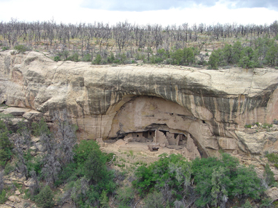
Cliffhouse Sandstone of the Mesaverde Formation forms the caprock of the plateau at Mesa Verde National Park.
Cretaceous, Late*
Santonian*
Campanian*
Yellowstone province*
Orogrande basin*
San Juan basin*
Wind River basin*
Paradox basin*
Green River basin*
Big Horn basin*
Black Mesa basin*
Powder River basin*
Piceance basin*
Uinta basin*
Eagle basin
AZ*
CO*
ID*
MT(se)*
NM*
UT*
WY*
Not designated. Derivation of name "Mesa Verde" not stated (Hayden, 1875).
Subunits:
Group rank (alphabetical): Allen Ridge formation (WY*), Almond Formation
(CO,WY*), Asphalt Ridge Sandstone (UT), Blackhawk Formation (UT*), Blair
Formation (UT*,WY*), Castlegate Sandstone (CO*,UT*), Cliff House Sandstone
(CO*,NM*), Crevasse Canyon Formation (AZ,NM), Ericson Formation (UT*,WY*)
or Ericson Sandstone (CO*,UT*,WY*), Farrer Formation (UT*), Gallup Sandstone
(AZ,CO,NM), Haystack Mountains Formation (WY*), Iles Formation (CO*,UT),
Hunter Canyon Formation (CO*), La Cruz Peak Formation (NM), Menefee Formation
(CO*,NM*), Mount Garfield Formation (CO*), Neslen Formation (CO*,UT*),
Pine Ridge Sandstone (WY*), Point Lookout Sandstone (CO*,NM*), Price River
Formation (UT*), Rim Rock Sandstone (CO,UT), Rock River Formation (WY*),
Rock Springs Formation (UT*,WY*), Rough Rock Sandstone (AZ*), Sego Sandstone
(CO*,UT*), Star Point Sandstone (UT*), Tohachi Formation (AZ*,NM*), Toreva
Formation (AZ*), Tuscher Formation (UT*), Twentymile Sandstone (CO), Wepo
Formation (AZ*), Williams Fork Formation (CO*,UT), Yale Point Sandstone
(AZ*).
Formation rank (alphabetical): Allison Member (NM), /Ardmore Bentonite
Beds (WY*), Ash Canyon Member (NM), Atarque Member (NM), Bartlett Member
(NM), Bowie Shale Member (CO*), Cano Member (NM), Cozzette Member (CO,UT),
/Deep Creek Sandstone Member (WY), Dilco Coal Member (NM*), Fales Sandstone
Member (WY*), Gibson Coal Member (NM), Hatfield Sandstone Member (WY),
Ohio Creek Member (CO*), Paonia Shale Member (CO*), Parkman Sandstone
Member (MT*,WY*), Pumpkin Buttes Member (WY), Rollins Sandstone Member
(CO*), Teapot Sandstone Member (MT*,WY*), Tow Creek Sandstone Member (CO),
Wallace Creek Member (WY) or Wallace Creek Tongue (WY).
First used (Hayden, 1875). Revised (Fenneman and Gale, 1906; Lee, 1909, 1912). Revised; Areal limits (Lupton, 1916). Revised (Collier, 1919). Revised; Areal limits (Ball, 1924). Revised (Hancock, 1925; Spieker and Reeside, 1925; Sears, 1925, 1926). Not used in Denver basin, northeast CO (Mather and others, 1928). Overview (Thom and Spieker, 1931). Revised (Sears, 1934; Erdmann, 1934; Dane, 1936; Fisher, 1936; Walton, 1944). Revised; Overview (Pike, 1947). Revised (Allen and Balk, 1954; Wright, 1954; Bushnell, 1955; Hayes and Zapp, 1955; Beaumont and others, 1956; Bodine, 1956; Repenning and Page, 1956; Dane and others, 1957; Barwin, 1959; Fisher and others, 1960; Hale, 1961; Sabins and Peterson, 1961; Gaskill and Godwin, 1963). Overview, Revised (Gill and others, 1970). Overview (Izett and others, 1970; Cullins, 1971). Revised; Overview (Collins, 1976). Revised (Johnson and May, 1980). Revised; Areal limits (Sargent and Hansen, 1982). Revised; Age modified to late Santonian to late Campanian in northwest Uinta basin (Fouch and others, 1983). Not used in Cibola and Catron Cos, NM (McLellan and others, 1983). Not used in west-central NM, (Molenaar, 1983). Revised (Bader and others, 1983; Miller, 1984; Brownfield and Johnson, 1986). Overview (Lozinsky, 1986; Roehler, 1987). Revised (Franczyk, 1988). Isotopic dating (Marvin and Mehnert, 1988). Areal limits (GNU staff remark, 1988; Molenaar and Baird, 1989). Overview (Law and Johnson, 1989; Johnson, 1989). Revised (Love, 1989; Hail, 1990). Biostratigraphic dating (Scott and Pantea, 1990). Areal limits (Fouch and others, 1992). Overview (Johnson, 1993).
References
Hayden, F.V., 1875, Report on the San Juan district, Colorado: U.S. Geological Survey Annual Report, 9, p. 245-248.
Fenneman, N.M. and Gale, H.S., 1906, The Yampa coal field, Routt County, Colorado: U.S. Geological Survey Bulletin, 297, p. 7-81.
Lee, W.T., 1909, The Grand Mesa coal field, Colorado: U.S. Geological Survey Bulletin, 341, p. 316-334.
Lee, W.T., 1912, Coal fields of Grand Mesa and the West Elk Mountains, Colorado: U.S. Geological Survey Bulletin, 510, 237 p.
Lupton, C.T., 1916, Oil and gas near Basin, Big Horn County, Wyoming,
IN Contributions to economic geology, 1915; Part 2, Mineral fuels: U.S.
Geological Survey Bulletin, 621-L, p.
L157-L190.
Collier, A.J., 1919, Coal south of Mancos, Montezuma County, Colorado,
IN Contributions to economic geology, 1918; Part 2, Mineral fuels: U.S.
Geological Survey Bulletin, 691-K, p.
K293-K310.
Ball, M.W., 1924, Gas near Fort Collins, Colorado: American Association of Petroleum Geologists Bulletin, v. 8, no. 1, p. 79-87.
Spieker, E.M. and Reeside, J.B., Jr., 1925, Cretaceous and Tertiary formations of the Wasatch Plateau, Utah: Geological Society of America Bulletin, v. 36, no. 3, p. 435-454.
Sears, J.D., 1925, Geology and coal resources of the Gallup-Zuni basin, New Mexico: U.S. Geological Survey Bulletin, 767, 53 p.
Hancock, E.T., 1925, Geology and coal resources of the Axial and Monument Butte quadrangles, Moffat County, Colorado: U.S. Geological Survey Bulletin, 757, 134 p.
Sears, J.D., 1926, Geology of the Baxter basin gas field, Sweetwater County, Wyoming, IN Contributions to economic geology (short papers and preliminary reports), 1925; Part 2, Mineral fuels: U.S. Geological Survey Bulletin, 781-B, p.B13-B27.
Mather, K.F., Gilluly, James and Lusk, R.G., 1928, Geology and oil and gas prospects of northeastern Colorado, IN Contributions to economic geology, 1927; Part 2, Mineral fuels: U.S. Geological Survey Bulletin, 796-B, p. B65-B124.
Thom, W.T., Jr. and Spieker, E.M., 1931, The significance of geologic conditions in Naval Petroleum Reserve No. 3 , Wyoming: U.S. Geological Survey Professional Paper, 163, 64 p.
Erdmann, C.E., 1934, The Book Cliffs coal field in Garfield and Mesa Counties, Colorado: U.S. Geological Survey Bulletin, 851, 150 p.
Sears, J.D., 1934, The coal field from Gallup eastward toward Mount Taylor;
Part 1, IN Sears, J.D., Hunt, C.B., and Dane, C.H., Geology and fuel resources
of the southern part of the
San Juan basin, New Mexico: U.S. Geological Survey Bulletin, 860-A, p.
1-29.
Fisher, L.W., 1936, Minerals in the Bates limestone, Lewiston, Maine: American Mineralogist, v. 21, no. 5, p. 321-326.
Dane, C.H., 1936, The La Ventana-Chacra Mesa coal field, Part 3, IN Sears,
J.D., Hunt, C.B., and Dane, C.H., Geology and fuel resources of the southern
part of the San Juan basin,
New Mexico: U.S. Geological Survey Bulletin, 860-C, p. 81-161.
Walton, P.T., 1944, Geology of the Cretaceous of the Uinta basin, Utah: Geological Society of America Bulletin, v. 55, no. 1, p. 91-130.
Pike, W.S., Jr., 1947, Intertonguing marine and nonmarine Upper Cretaceous deposits of New Mexico, Arizona, and southwestern Colorado: Geological Society of America Memoir, 24, 103 p.
Wright, H.E., Jr., 1954, Tohatchi formation, Chuska Mountains, Arizona-New Mexico: American Association of Petroleum Geologists Bulletin, v. 38, no. 8, p. 1827-1834.
Allen, J.E. and Balk, R., 1954, Mineral Resources of Fort Defiance and Tohatchi quadrangles, Arizona and New Mexico: New Mexico Bureau of Mines and Mineral Resources Bulletin, no. 36, 192 p.
Hayes, P.T. and Zapp, A.D., 1955, Geology and fuel resources of the Upper Cretaceous rocks of the Barker Dome-Fruitland area, San Juan County, New Mexico: U.S. Geological Survey Oil and Gas Investigations Map, OM-144, 2 sheets, scale 1:62,500.
Bushnell, H.P., 1955, Mesozoic stratigraphy of south-central New Mexico, IN Fitzsimmons, J.P., ed., Guidebook of south-central New Mexico: New Mexico Geological Society Guidebook, no. 6, November 11-13, 1955, p. 81-87.
Beaumont, E.C., Dane, C.H. and Sears, J.D., 1956, Revised nomenclature
of Mesaverde Group in San Juan basin, New Mexico: American Association
of Petroleum Geologists Bulletin, v.
40, no. 9, p. 2149-2162.
Repenning, C.A. and Page, H.G., 1956, Late Cretaceous stratigraphy of Black Mesa, Navajo and Hopi Indian Reservations, Arizona: American Association of Petroleum Geologists Bulletin, v. 40, no. 2, p. 255-294.
Bodine, M.W., Jr., 1956, Geology of the Capitan coal field, Lincoln County, New Mexico: New Mexico Bureau of Mines and Mineral Resources Circular, no. 35.
Dane, C.H., Wanek, A.A. and Reeside, J.B., Jr., 1957, Reinterpretation of section of Cretaceous rocks in Alamosa Creek Valley area, Catron and Socorro Counties, New Mexico: American Association of Petroleum Geologists Bulletin, v. 41, no. 2, p. 181-196.
Barwin, J.R., 1959, Facies of the Mesaverde formation, east-central Wyoming,
IN Geological record: American Association of Petroleum Geologists, Rocky
Mountain Section, 9th Annual
Meeting, February, 1959, p. 139-142.
Fisher, D.J., Erdmann, C.E. and Reeside, J.B., Jr., 1960, Cretaceous and Tertiary formations of the Book Cliffs, Carbon, Emery, and Grand Counties, Utah, and Garfield and Mesa Counties, Colorado: U.S. Geological Survey Professional Paper, 332, 80 p.
Sabins, F.F. and Peterson, F.A., 1961, Geology and petrography of Dead Horse Creek and Barber Creek fields, IN Symposium on Late Cretaceous rocks, Wyoming and adjacent areas: Wyoming Geological Association Field Conference Guidebook, no. 16, p. 301-309.
Hale, L.A., 1961, Late Cretaceous (Montanan) stratigraphy eastern Washakie basin, Carbon County, Wyoming, IN Symposium on Late Cretaceous rocks, Wyoming and adjacent areas: Wyoming Geological Association Field Conference Guidebook, no. 16, p. 129-137.
Gaskill, D.L. and Godwin, L.H., 1963, Redefinition and correlation of
the Ohio Creek Formation (Paleocene) in west-central Colorado; Article
69, IN Geological Survey research 1963;
short papers in geology and hydrology; Articles 60-121: U.S. Geological
Survey Professional Paper, 475-C, p. C35-C38.
Warner, D.L., 1964, Mancos-Mesaverde (Upper Cretaceous) intertonguing relations southeast Piceance basin, Colorado: American Association of Petroleum Geologists Bulletin, v. 48, no. 7, p. 1091-1107.
Gill, J.R., Merewether, E.A. and Cobban, W.A., 1970, Stratigraphy and
nomenclature of some Upper Cretaceous and lower Tertiary rocks in south-central
Wyoming: U.S. Geological Survey
Professional Paper, 667, 53 p.
Izett, G.A., Cobban, W.A. and Gill, J.R., 1971, The Pierre Shale near
Kremmling, Colorado, and its correlation to the east and the west, IN
Shorter contributions to general geology,
1970: U.S. Geological Survey Professional Paper, 684-A, p. A1-A19.
Cullins, H.L., 1971, Geologic map of the Rangely quadrangle, Rio Blanco County, Colorado: U.S. Geological Survey Geologic Quadrangle Map, GQ-903, 1 sheet, scale 1:24,000.
Collins, B.A., 1976, Coal deposits of the Carbondale, Grand Hogback,
and southern Danforth Hills coal fields, eastern Piceance basin, Colorado:
Colorado School of Mines Quarterly,
v. 71, no. 1.
Johnson, R.C. and May, Fred, 1980, A study of the Cretaceous-Tertiary unconformity in the Piceance Creek basin, Colorado; the underlying Ohio Creek Formation (Upper Cretaceous) redefined as a member of the Hunter Canyon or Mesaverde Formation, IN Contributions to stratigraphy: U.S. Geological Survey Bulletin, 1482-B, p. B1-B27.
Sargent, K.A. and Hansen, D.E., 1982, Bedrock geologic map of the Kaiparowits coal-basin area, Utah: U.S. Geological Survey Miscellaneous Investigations Series Map, I-1033-I, 1 sheet.
Bader, J.W., Gill, J.R., Cobban, W.A. and Law, B.E., 1983, Biostratigraphic correlation chart of some Upper Cretaceous rocks from the Lost Soldier area, Wyoming, to west of Craig, Colorado: U.S. Geological Survey Miscellaneous Field Studies Map, MF-1548, 1 sheet.
Molenaar, C.M., 1983, A principal reference section and correlation of the Gallup Sandstone, northwestern New Mexico: New Mexico Bureau of Mines and Mineral Resources Circular, no. 185, p. 29-40.
McLellan, M.W., Haschke, L.R., Robinson, L.N., Carter, M.D. and Medlin,
A.L., 1983, Middle Turonian and younger Cretaceous rocks, northern Salt
Lake coal field, Cibola and Catron
Counties, New Mexico, IN Hook, S.C., compiler, Contributions to mid-Cretaceous
paleontology and stratigraphy of New Mexico; Part II: New Mexico Bureau
of Mines and Mineral Resources
Circular, no. 185, p. 41-47.
Fouch, T.D., Lawton, T.F., Nichols, D.J., Cashion, W.B. and Cobban, W.A., 1983, Patterns and timing of synorogenic sedimentation in Upper Cretaceous rocks of central and northeast Utah, IN Reynolds, M.W., and Dolly, E.D., editors, Mesozoic paleogeography of the west-central United States: Society of Economic Paleontologists and Mineralogists, Rocky Mountain Section, Rocky Mountain Paleogeography Symposium, v. 2, p. 305-336.
Miller, R.L., 1984, Subdivisions of the Menefee Formation and Cliff House
Sandstone (Upper Cretaceous) in southwest San Juan basin, New Mexico,
IN Stratigraphic notes, 1983: U.S.
Geological Survey Bulletin, 1537-A, p. A29-A53.
Brownfield, M.E. and Johnson, E.A., 1986, A regionally extensive altered
air-fall ash for use in correlation of lithofacies in the Upper Cretaceous
Williams Fork Formation, northeastern Piceance Creek and southern Sand
Wash basins, Colorado, IN Stone, D.S., and Johnson, K.S., editors, New interpretations
of northwest Colorado geology: Rocky Mountain Association of
Geologists Field Conference Guidebook, p. 165-170.
Lozinsky, R.P., 1986, Geologic and late Cenozoic history of the Elephant Butte area, Sierra County, New Mexico: New Mexico Bureau of Mines and Mineral Resources Circular, no. 187.
Roehler, H.W., 1987, Surface-subsurface correlations of the Mesaverde Group and associated Upper Cretaceous formations, Rock Springs, Wyoming to Mount Harris, Colorado: U.S. Geological Survey Miscellaneous Field Studies Map, MF-1937, 1 sheet, scale 1 in. = 200 ft.
GNU Staff, 1988, GNU Staff remark by T.W. Judkins. Use of Mesaverde Group
or Formation in southern Piceance basin (oral communication with R.C.
Johnson, U.S. Geological Survey,
8-24-88).: U.S. Geological Survey, unpublished geologic names committee
note.
Franczyk, K.J., 1988, Stratigraphic revision and depositional environments of the Upper Cretaceous Toreva Formation in the northern Black Mesa area, Navajo and Apache Counties, Arizona: U.S. Geological Survey Bulletin, 1685, 32 p.
Marvin, R.F. and Mehnert, H.H., 1988, Radiometric ages; compilation "C", U.S. Geological Survey; Part two, Arizona and New Mexico: Isochron/West, no. 51, p. 5-13.
Love, J.D., 1989, Names and descriptions of new and reclassified formations in northwestern Wyoming, IN Love, J.D., ed., Geology of the Teton-Jackson Hole region, northwestern Wyoming: U.S. Geological Survey Professional Paper, 932-C, p. C1-C45.
Law, B.E. and Johnson, R.C., 1989, Structural and stratigraphic framework
of the Pinedale anticline, Wyoming, and Multiwell Experiment site, Colorado,
IN Law, B.E., and Spencer, C.W.,
editors, Geology of tight gas reservoirs in the Pinedale anticline area,
Wyoming, and at the Multiwell Experiment site, Colorado: U.S. Geological
Survey Bulletin, 1886-B, p. B1-B11.
Molenaar, C.M. and Baird, J.K., 1989, North-south stratigraphic cross
sections of Upper Cretaceous rocks, northern San Juan basin, southwestern
Colorado: U.S. Geological Survey
Miscellaneous Field Studies Map, MF-2068, 3 sheets.
Johnson, R.A., 1989, Geologic descriptions of selected exposures in Florida: Florida Geological Survey Special Publication, no. 30, 174 p.
Scott, R.W., Jr. and Pantea, M.P., 1990, Geologic map of the Texas Creek
quadrangle, Rio Blanco County, Colorado: U.S. Geological Survey Miscellaneous
Field Studies Map, MF-2134,
1 sheet.
Hail, W.J., Jr., 1990, Geology of the lower Yellow Creek area, northwestern
Colorado, IN Evolution of sedimentary basins; Uinta and Piceance basins:
U.S. Geological Survey Bulletin,
1787-O, p. O1-O45.
Fouch, T.D., Nuccio, V.F., Osmond, J.C., MacMillan, Logan, Cashion, W.B.
and Wandrey, C.J., 1992, Oil and gas in uppermost Cretaceous and Tertiary
rock, Uinta basin, Utah, IN Fouch,
T.D., Nuccio, V.F., and Chidsey, T.C., Jr., editors, Hydrocarbon and mineral
resources of the Uinta basin, Utah and Colorado; 1992 field symposium:
Utah Geological Association Guidebook,
no. 20, p. 9-48.
Johnson, R.C. and Smith, M.C., 1993, Geologic map of the Philadelphia
Creek quadrangle, Rio Blanco County, Colorado: U.S. Geological Survey
Miscellaneous Field Studies Map,
MF-2216, 1 sheet.
Fox, J.E., 1993, Stratigraphic cross sections showing electric logs of Upper Cretaceous and older rocks, Powder River basin, southeastern Montana and northeastern Wyoming: U.S. Geological Survey Oil and Gas Investigations Chart, OC-135 to OC-138, 4 sheets, sections A-A' trhough F-F'; G-G' through L-L'; M-M' through R-R'; S-S' through V-V'
Johnson, Ronald C., 2003, Depositional framework of the Upper Cretaceous
Mancos Shale and
the lower part of the Upper Cretaceous Mesaverde Group, western Colorado
and eastern Utah: U. S. Geological Survey Digital Data Series, Report:
DDS-0069-B, 24 p.
Hettinger, R. D., and Kirschbaum, Mark A, 2003, Stratigraphy of the Upper
Cretaceous Mancos Shale (upper part) and Mesaverde Group in the southern
part of the Uinta and Piceance
basins, Utah and Colorado: U. S. Geological Survey Digital Data Series,
Report: DDS-0069-B,
21 p.
Hettinger, R. D., and Kirschbaum, M. A., 2002, Stratigraphy of the Upper
Cretaceous Mancos Shale (upper part) and Mesaverde Group in the southern
part of the Uinta and Piceance
basins, Utah and Colorado: U.S. Geological Survey, Geologic Investigations
Series I-2764, 21 pp., 2 sheets <http://greenwood.cr.usgs.gov/pub/i-maps/i-2764/>.
Seidler, Lars, and Steel, Ron, 2001, Pinch-out style and position of tidally influenced strata in a regressive-transgressive wave-dominated deltaic sandbody, Twentymile Sandstone, Group, NW Colorado: Sedimentology, vol.48, no.2, pp.399-414.
Willis, A., 2000, Tectonic control of nested sequence architecture in the Sego Sandstone, Neslen Formation and upper Castlegate Sandstone (Upper Cretaceous), Sevier foreland basin, Utah, USA: Sedimentary Geology, v. 136, no. 3-4, p. 277-317.
Taylor, Kevin G., Gawthorpe, Rob L., Curtis, Charles D., Marshall, Jim D., and Awwiller, David N., 2000, Carbonate cementation in a sequence-stratigraphic framework: Upper Cretaceous sandstones, Book Cliffs, Utah-Colorado: Journal of Sedimentary Research, v. 70, no. 2, p. 360-372.
Pedersen, Peter Kent, and Steel, Ron, 1999, Sequence stratigraphy and alluvial architecture of the Upper Cretaceous Ericson Sandstone, Glades-Clay Basin area, Wyoming/Utah border: The Mountain Geologist, v. 36, no. 2, p. 71-83.
Olsen, T., Steel, R., Hogseth, K., Skar, T., and Roe, S. L., 1995, Sequential
architecture in a fluvial succession; sequence stratigraphy in the Upper
Cretaceous Mesaverde Group, Prince
Canyon, Utah: Journal of Sedimentary Research, Section B: Stratigraphy
and Global Studies, v. 65, no. 2, p. 265-280.
Hamilton, Douglas S., 1994, Stratigraphy and coal occurrence of the Upper Cretaceous Mesaverde Group, Sand Wash Basin: University of Texas at Austin, Bureau of Economic Geology, Austin, TX: Report of Investigations 220, p. 23-49.