Mancos Shale
Mancos Shale (AZ*,CO*,NM*,UT*,WY*)
Mancos Group (CO*,UT*)
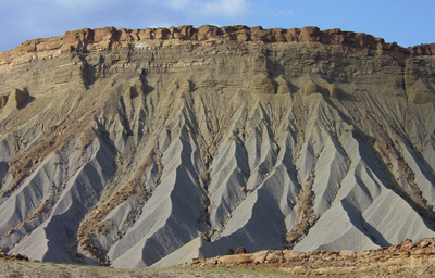
This view shows part of the Mancos Shale where is crops out along the Notom-Bullfrog Road in southern Capitol Reef National Park.
Cretaceous, Early* (local)
Albian* (local)
Cretaceous, Late*
Cenomanian*
Turonian*
Coniacian*
Santonian*
Campanian*
Basin and Range province*
Black Mesa basin*
Estancia basin*
Green River basin*
Orogrande basin*
Paradox basin*
Piceance basin*
Plateau sedimentary province*
San Juan basin*
San Juan Mountains province*
Uinta basin*
AZ*
CO*
NM(n)*
UT*
WY(c)*
No type designated. Named for occurrence in Mancos Valley and around town of Mancos, between La Plata Mountains and Mesa Verde, Montezuma Co., CO (Cross, 1899).Type section for "Mancos B" subsurface unit within Mancos shale designated at 2349-2830 ft interval in General Petroleum Douglas Creek No. 1, sec. 24, T. 2 S., R. 103 W., Rio Blanco Co., CO (Kellogg, 1977).
Group rank (alphabetical): Buck Tongue (CO*), Frontier Formation (CO*,UT*), Mowry Shale (CO*,UT*). Formation rank (alphabetical): Anchor Mine Tongue (CO*,UT*), Aspen Member (UT,WY), /Black Butte Tongue (WY), Blue Gate Member (UT*), Bridge Creek Limestone Member (NM*), Buck Tongue (CO*,UT*), Bull Point Sandstone Member (UT), Carlile Member (NM*), Clay Mesa Tongue (NM*), Cooper Arroyo Sandstone Member (NM*), Emery Sandstone Member (UT*), D-Cross Tongue (NM*), Devils Grave Sandstone [Member] (CO), El Vado Sandstone Member (NM*), Ferron Sandstone Member (CO*,UT*), Fort Hays Limestone Member (CO*), Fort Hays Limestone Member (CO*), Garley Canyon Sandstone Member (UT*), Graneros Member (CO,NM*), Greenhorn Limestone Member (NM*), Hartland Shale Beds (NM), /Hopi Sandy Member (AZ), Horsehead Tongue (NM), Hunt Creek Sandstone [Member] (CO), Juana Lopez Member (CO*,NM*), Loyd Sandstone Member (CO*), Masuk Member (UT*) or Masuk Tongue (UT), Meeker Sandstone Member (CO*), Morapos Sandstone Member (CO*), Mowry Member (UT*), Mulatto Tongue (NM*), Muley Canyon Sandstone Member (UT), Niobrara Member (CO*,NM*), Pescado Tongue (AZ*,NM*), Rangely Tongue (CO,UT), Rio Salado Tongue (NM*), Sanastee Sandstone Member (NM), Satan Tongue (NM*), Semilla Sandstone Member (NM*), Tocito Sandstone Lentil (CO,NM*), Tununk Member (UT*), Whitewater Arroyo Tongue (NM*), Wildcat Canyon Sandstone Member (UT), Wind Rock Tongue (AZ).
Unit Name History:
Named (Cross and Purington, 1899). Revised (Lee, 1912; Lupton, 1914; Collier,
1919; Reeside, 1924; Spieker and Reeside, 1925; Clark, 1928; Erdmann,
1934; Sears, 1934; Hunt, 1936; Fisher, 1936). Revised; Overview (Pike,
1947). Revised (Dane, 1948; Hale, 1955; Beaumont and others, 1956). Revised;
Overview (Repenning and Page, 1956). Revised (Dane and others, 1957; Young,
1959). Overview (Fisher and others, 1960; Dyni and Cullins, 1965). Revised
(Carter and Gualtieri, 1965; Landis and Dane, 1967; Dane and others, 1968;
Dickinson and others, 1968; Correa, 1970). Overview (Izett and others,
1971). Revised (Landis and others, 1973; Hail, 1974). Biostratigraphic
dating; Isotopic dating (Obradovich and Cobban, 1975). First published
use of subsurface "Mancos B" unit (Kellogg, 1977). Revised;
Reference (Fassett and Jentgen, 1978). Revised; Areal limits (Sargent
and Hansen, 1982). Revised; Overview (Hook and others, 1983). Age modified;
Overview (Fouch and others, 1983). Overview (Smith, 1983). Mapped 1:24k
(O'Sullivan, 1985). Revised (Franczyk, 1988). Overview (Kirk and others,
1988). Biostratigraphic dating (Cobban, 1988a, 1988b, 1988c; Cobban and
Hook, 1989; Cobban and Kennedy, 1989). Areal limits (Molenaar and Baird,
1989). Age modified locally; Biostratigraphic dating; Revised (Molenaar
and Wilson, 1990). Revised (Eaton, 1990; Molenaar and Cobban, 1991). Revised;
Areal limits (Johnson and Johnson, 1991). Biostratigraphic dating; Hopi
Sandy Member named (Kirkland, 1991).
References
Cross, C.W. and Purington, C.W., 1899, Description of the Telluride quadrangle [Colorado]: U.S. Geological Survey Geologic Atlas of the United States, Telluride folio, no. 57, 18 p.
Lee, W.T., 1912, Coal fields of Grand Mesa and the West Elk Mountains, Colorado: U.S. Geological Survey Bulletin, 510, 237 p.
Lupton, C.T., 1914, Oil and gas near Green River, Grand County, Utah,
IN Contributions to economic geology, 1912; Part 2, Mineral fuels: U.S.
Geological Survey Bulletin, 541-D, p.
D115-D133.
Collier, A.J., 1919, Coal south of Mancos, Montezuma County, Colorado,
IN Contributions to economic geology, 1918; Part 2, Mineral fuels: U.S.
Geological Survey Bulletin, 691-K, p.
K293-K310.
Reeside, J.B., Jr., 1924, Upper Cretaceous and Tertiary formations of
the western part of the San Juan basin of Colorado and New Mexico: U.S.
Geological Survey Professional Paper, 134,
117 p.
Spieker, E.M. and Reeside, J.B., Jr., 1925, Cretaceous and Tertiary formations of the Wasatch Plateau, Utah: Geological Society of America Bulletin, v. 36, no. 3, p. 435-454.
Sears, J.D., 1934, The coal field from Gallup eastward toward Mount Taylor;
Part 1, IN Sears, J.D., Hunt, C.B., and Dane, C.H., Geology and fuel resources
of the southern part of the
San Juan basin, New Mexico: U.S. Geological Survey Bulletin, 860-A, p.
1-29.
Erdmann, C.E., 1934, The Book Cliffs coal field in Garfield and Mesa Counties, Colorado: U.S. Geological Survey Bulletin, 851, 150 p.
Fisher, L.W., 1936, Minerals in the Bates limestone, Lewiston, Maine: American Mineralogist, v. 21, no. 5, p. 321-326.
Hunt, C.B., 1936, The Mount Taylor coal field, Part 2, IN Sears, J.D., Hunt, C.B., and Dane, C.H., Geology and fuel resources of the southern part of the San Juan basin, New Mexico: U.S. Geological Survey Bulletin, 860-B, p. 31-80.
Pike, W.S., Jr., 1947, Intertonguing marine and nonmarine Upper Cretaceous deposits of New Mexico, Arizona, and southwestern Colorado: Geological Society of America Memoir, 24, 103 p.
Dane, C.H., 1948, Geology and oil possibilites of the eastern side of
the San Juan basin, Rio Arriba County, New Mexico: U.S. Geological Survey
Oil and Gas Investigations Map, OM-78,
1 sheet, scale 1:63,360, Reprinted 1957.
Hale, L.A., 1955, Stratigraphy and facies relationship of the Montanan
Group in south-central Wyoming, northeastern Utah, and northwestern Colorado,
IN Camp, R.J., chairman, Green
River basin: Wyoming Geological Association Field Conference Guidebook,
no. 10, p. 89-94.
Repenning, C.A. and Page, H.G., 1956, Late Cretaceous stratigraphy of Black Mesa, Navajo and Hopi Indian Reservations, Arizona: American Association of Petroleum Geologists Bulletin, v. 40, no. 2, p. 255-294.
Beaumont, E.C., Dane, C.H. and Sears, J.D., 1956, Revised nomenclature
of Mesaverde Group in San Juan basin, New Mexico: American Association
of Petroleum Geologists Bulletin, v.
40, no. 9, p. 2149-2162.
Dane, C.H., Wanek, A.A. and Reeside, J.B., Jr., 1957, Reinterpretation of section of Cretaceous rocks in Alamosa Creek Valley area, Catron and Socorro Counties, New Mexico: American Association of Petroleum Geologists Bulletin, v. 41, no. 2, p. 181-196.
Young, R.G., 1959, Cretaceous deposits of the Grand Junction area, Garfield,
Mesa, and Delta Counties, Colorado, IN Symposium on Cretaceous rocks of
Colorado and adjacent areas;
Washakie, Sand Wash, and Piceance basins: Rocky Mountain Association of
Geologists Field Conference Guidebook, no. 11, p. 1-8.
Fisher, D.J., Erdmann, C.E. and Reeside, J.B., Jr., 1960, Cretaceous and Tertiary formations of the Book Cliffs, Carbon, Emery, and Grand Counties, Utah, and Garfield and Mesa Counties, Colorado: U.S. Geological Survey Professional Paper, 332, 80 p.
Carter, W.D. and Gualtieri, J.L., 1965, Geyser Creek Fanglomerate (Tertiary), La Sal Mountains, eastern Utah, IN Contributions to stratigraphy, 1965: U.S. Geological Survey Bulletin, 1224-E, p. E1-E11.
Dyni, J.R. and Cullins, H.L., 1965, Meeker and Loyd Sandstone Members
of the Mancos Shale, Moffat and Rio Blanco Counties, Colorado, IN Contributions
to stratigraphy: U.S. Geological
Survey Bulletin, 1194-J, p. J1-J7.
Landis, E.R. and Dane, C.H., 1967, Geologic map of the Tierra Amarilla
quadrangle, Rio Arriba County, New Mexico, with description: New Mexico
Bureau of Mines and Mineral Resources
Geologic Map, 19, 1 sheet, scale 1:62,500.
Dickinson, R.G., Leopold, E.B. and Marvin, R.F., 1968, Late Cretaceous uplift and volcanism on the north flank of the San Juan Mountains, Colorado: Colorado School of Mines Quarterly, v. 63, no. 3, p. 125-148.
Dane, C.H., Kauffman, E.G. and Cobban, W.A., 1968, Semilla Sandstone, a new member of the Mancos Shale in the southeastern part of the San Juan basin, New Mexico, IN Contributions to stratigraphy: U.S. Geological Survey Bulletin, 1254-F, p. F1-F21.
Correa, A.C., 1970, Borrego Pass Lentil, a new member of the Crevasse Canyon Formation, southern San Juan basin, New Mexico: The Mountain Geologist, v. 7, no. 2, p. 99-102.
Izett, G.A., Cobban, W.A. and Gill, J.R., 1971, The Pierre Shale near Kremmling, Colorado, and its correlation to the east and the west, IN Shorter contributions to general geology, 1970: U.S. Geological Survey Professional Paper, 684-A, p.A1-A19.
Landis, E.R., Dane, C.H. and Cobban, W.A., 1973, Stratigraphic terminology
of the Dakota Sandstone and Mancos Shale, west-central New Mexico, IN
Contributions to stratigraphy:
U.S. Geological Survey Bulletin, 1372-J, p. J1-J44.
Hail, W.J., Jr., 1974, Geologic map of the Rough Gulch quadrangle, Rio
Blanco and Moffat Counties, Colorado: U.S. Geological Survey Geologic
Quadrangle Map, GQ-1195, 1 sheet, scale
1:24,000.
Obradovich, J.D. and Cobban, W.A., 1975, A time-scale for the Late Cretaceous of the Western Interior of North America, IN Caldwell, W.G., ed., The Cretaceous System in the Western Interior of North America: Geological Association of Canada Special Paper, 13, p. 31-54.
Kellogg, H.E., 1977, Geology and petroleum of the Mancos B Formation,
Douglas Creek arch area, Colorado and Utah, IN Veal, H.K., ed., Symposium
on exploration frontiers of the
central and southern Rockies: Rocky Mountain Association of Geologists
Field Conference Guidebook, p. 167-179.
Fassett, J.E. and Jentgen, R.W., 1978, Blanco Tocito, South (oil), IN
Fassett, J.E., and Thomaidis, N.D., editors, Oil and gas fields of the Four
Corners area: Four Corners Geological
Society, v. 1, p. 233-240.
Sargent, K.A. and Hansen, D.E., 1982, Bedrock geologic map of the Kaiparowits coal-basin area, Utah: U.S. Geological Survey Miscellaneous Investigations Series Map, I-1033-I, 1 sheet.
Smith, Curtis, 1983, Geology, depositional environments, and coal resources
of the Mt. Pennell 2 NW quadrangle, Garfield County, Utah: Brigham Young
University Geology Studies, v.
30, pt. 1, p. 145-169.
Hook, S.C., Molenaar, C.M. and Cobban, W.A., 1983, Stratigraphy and revision of nomenclature of upper Cenomanian to Turonian (Upper Cretaceous) rocks of west-central New Mexico: New Mexico Bureau of Mines and Mineral Resources Circular, no. 185, p. 7-28.
Fouch, T.D., Lawton, T.F., Nichols, D.J., Cashion, W.B. and Cobban, W.A., 1983, Patterns and timing of synorogenic sedimentation in Upper Cretaceous rocks of central and northeast Utah, IN Reynolds, M.W., and Dolly, E.D., editors, Mesozoic paleogeography of the west-central United States: Society of Economic Paleontologists and Mineralogists, Rocky Mountain Section, Rocky Mountain Paleogeography Symposium, v. 2, p. 305-336.
O'Sullivan, R.B., 1985, Preliminary geologic map of the Rio Blanco quadrangle,
Rio Blanco and Garfield Counties, Colorado: U.S. Geological Survey Miscellaneous
Field Studies Map,
MF-1816, 1 sheet.
Cobban, W.A., 1988, Tarrantoceras Stephenson and related ammonoid genera from Cenomanian (Upper Cretaceous) rocks in Texas and the Western Interior of the United States: U.S. Geological Survey Professional Paper, 1473, 51 p.
Kirk, A.R., Huffman, A.C., Jr. and Zech, R.S., 1988, Subsurface correlation of Jurassic and Cretaceous rocks having occurrences of uranium, coal, and oil; Mariano Lake-Lake Valley drilling project, northwestern New Mexico: U.S. Geological Survey Oil and Gas Investigations Chart, OC-130, 1 sheet.
Franczyk, K.J., 1988, Stratigraphic revision and depositional environments of the Upper Cretaceous Toreva Formation in the northern Black Mesa area, Navajo and Apache Counties, Arizona: U.S. Geological Survey Bulletin, 1685, 32 p.
Cobban, W.A., 1988, The Upper Cretaceous ammonite Watinoceras Warren in the Western Interior of the United States, IN Contributions to paleontology: U.S. Geological Survey Bulletin, 1788, 15 p.
Cobban, W.A., 1988, The Late Cretaceous ammonite Spathites Kummel and
Decker in New Mexico and Trans-Pecos Texas, IN Cobban, W.A., Kennedy,
W.J., and Hook, S.C., Contributions to Late Cretaceous paleontology and
stratigraphy of New Mexico; Part
II: New Mexico Bureau of Mines and Mineral Resources Bulletin, no. 114,
p. 5-21.
Molenaar, C.M. and Baird, J.K., 1989, North-south stratigraphic cross
sections of Upper Cretaceous rocks, northern San Juan basin, southwestern
Colorado: U.S. Geological Survey
Miscellaneous Field Studies Map, MF-2068, 3 sheets.
Cobban, W.A. and Kennedy, W.J., 1989, Variation and ontogeny of Calycoceras
(Proeucalycoceras) canitaurinum (Haas, 1949) from the Upper Cretaceous
(Cenomanian) of the Western Interior of the United States, IN Sando, W.J.,
ed., Shorter contributions
to paleontology and stratigraphy: U.S. Geological Survey Bulletin, 1881-B,
p. B1-B7.
Cobban, W.A. and Hook, S.C., 1989, Mid-Cretaceous molluscan record from
west-central New Mexico, IN Anderson, O.J., and others, editors, Southeastern
Colorado Plateau: New Mexico
Geological Society Guidebook, no. 40, p. 247-264.
Eaton, J.G., 1990, Stratigraphic revision of Campanian (Upper Cretaceous) rocks in the Henry basin, Utah: The Mountain Geologist, v. 27, no. 1, p. 27-38.
Molenaar, C.M. and Wilson, B.W., 1990, The Frontier Formation and associated
rocks of northeastern Utah and northwestern Colorado, IN Evolution of
sedimentary basins; Uinta and
Piceance basins: U.S. Geological Survey Bulletin, 1787-M, p. M1-M21.
Kirkland, J.I., 1991, Lithostratigraphic and biostratigraphic framework
for the Mancos Shale (late Cenomanian to middle Turonian) at Black Mesa,
northeastern Arizona, IN Nations,
J.D., and Eaton, J.F., editors, Stratigraphy, depositional environments,
and sedimentary tectonics of the western margin, Cretaceous Western Interior
Seaway: Geological Society of
America Special Paper, 260, p. 85-111.
Johnson, S.Y. and Johnson, R.C., 1991, Stratigraphic and time-stratigraphic
cross sections of Phanerozoic rocks along line A-A', Uinta and Piceance
basin area-Eagle basin, Colorado,
to eastern Basin and Range area, Utah, IN Folio of the Uinta and Piceance
basin area: U.S. Geological Survey Miscellaneous Investigations Series
Map, I-2184-A, 2 sheets, scale 1:500,000.
Molenaar, C.M. and Cobban, W.A., 1991, Middle Cretaceous stratigraphy
on the south and east sides of the Uinta basin, northeastern Utah and
northwestern Colorado, IN Evolution of
sedimentary basins; Uinta and Piceance basins: U.S. Geological Survey
Bulletin, 1787-P, p. P1-P34.
Willis, Brian J., and Gabel, Sharon L., 2003, Formation of deep incisions
into tide-dominated river deltas; implications for the stratigraphy of
the Sego Sandstone, Book
Cliffs, Utah, U.S.A.: Journal of Sedimentary Research, v. 73, no. 2,
p. 246-263.
Kirschbaum, Mark A., 2003, Geologic assessment of undiscovered oil and
gas resources of the
Mancos/Mowry total petroleum system, Uinta-Piceance Province, Utah and
Colorado: In,
Petroleum systems and geologic assessment of oil and gas in the Uinta-Piceance
Province, Utah and Colorado: U. S. Geological Survey Digital Data Series,
DDS-0069-B, 42 p.
Hettinger, R D; Kirschbaum, Mark A, 2003, Stratigraphy of the Upper Cretaceous Mancos Shale (upper part) and Mesaverde Group in the southern part of the Uinta and Piceance basins, Utah and Colorado: U. S. Geological Survey Digital Data Series, DDS-0069-B, 21 p.
Hettinger, R. D., and Kirschbaum, M. A., 2002, Stratigraphy of the Upper
Cretaceous Mancos Shale (upper part) and Mesaverde Group in the southern
part of the Uinta and Piceance
basins, Utah and Colorado: U. S. Geological Survey, Geologic Investigations
Series I-2764, 21 p., 2 sheets. <http://greenwood.cr.usgs.gov/pub/i-maps/i-2764/>.
Willis, Brian J., and Gabel, Sharon, 2001, Sharp-based, tide-dominated deltas of the Sego Sandstone, Book Cliffs, USA: Sedimentology, v. 48, no. 3, p. 479-506.
Sealey, Paul L., and Lucas, Spencer G., 2000, Turonian ammonites from
the Upper Cretaceous Carlile, Semilla Sandstone and Juana Lopez members
of the Mancos Shale, Rio Puerco
Valley, Sandoval County, New Mexico: New Mexico Museum of Natural History
and Science,
Bulletin, v. 16, p. 137-143.
Sampson, Gary J., Howell, John A., and Flint, Stephen S., 1999, A sedimentological and sequence stratigraphic reinterpretation of the Upper Cretaceous Prairie Canyon Member ("Mancos B") and associated strata, Book Cliffs area, Utah, USA: Journal of Sedimentary Research, v. 69, no. 2, p. 414-433.
Godfrey, Andrew E., 1997, Quaternary geology and geomorphology, northern
Henry Mountains
region; wind erosion of Mancos Shale badlands; part 2: Geology Studies
(Brigham Young University, Department of Geology, Provo, UT), vol.42,
Part 2, p. 384-385.
Leckie, R. M., Kirkland, J. I., and Elder, W. P., 1997, Stratigraphic framework and correlation of a principal reference section of the Mancos Shale (Upper Cretaceous), Mesa Verde, Colorado: New Mexico Geological Society Guidebook, v. 48, p. 163-216.
Oboh-Ikuenobe, Francisca E., 1996, Correlating palynofacies assemblages with sequence stratigraphy in Upper Cretaceous (Campanian) sedimentary rocks of the Book Cliffs, east-central Utah: Geological Society of America Bulletin, v. 108, no. 10, p. 1275-1294.
Leithold, Elana L., 1994, Stratigraphical architecture at the muddy margin
of the Cretaceous
Western Interior Seaway, southern Utah: Sedimentology, v. 41, no. 3,
p. 521-542.