Kaibab Limestone
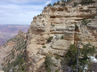
Kaibab Limestone on Grand Canyon's South Rim.
Early Middle Permian - 270 million years
(age used by National Park Service;
Mathis and Bowman, 2005)
Subunits: Formation rank (alphabetical):
Fossil Mountain Member (AZ*,NV*,UT), Harrisburg Member (AZ*,NV*,UT*).
Unit Name History: Named as upper formation of Aubrey Group (Darton,
1910). Revised, Harrisburg Member named (Bassler and Reeside, 1921). Areal
limits (Gilluly and Reeside, 1928; Gregory and Moore, 1931). Redescribed
as Kaibab Formation; lower contact revised and Kaibab informally divided
into (ascending): alpha, beta, and gamma units (McKee, 1938). Upper contact
revised (Blakey, 1974). Rraised to group rank and divided into several
formations; Areal limits (Welsh and others, 1979). Redescribed as Kaibab
Marble in CA; Areal limits (Hamilton, 1982). Redescribed as Kaibab Formation
(Ulrich and others, 1984). Redescribed as Kaibab Formation; Reference;
Revised, divided into (ascending): Fossil Mountain Member (new) and Harrisburg
Member (Sorauf and Billingsley, 1991). Areal limits (Anderson and Hintze,
1993).
Kaibab Formation (Lower Permian), undivided—Includes, in descending order, Harrisburg
and Fossil Mountain Members, undivided, as defined by Sorauf and Billingsley (1991).
Harrisburg Member—Reddish-gray and brownish-gray, slope-forming gypsum, siltstone, sandstone, and limestone. Informally subdivided, in descending order, into three units forming an upper slope, middle cliff, and lower slope. Upper slope unit is interbedded red and gray gypsum, sandstone, and siltstone, and yellowish-gray fossiliferous sandy limestone. Middle cliff unit is gray, thin-bedded, fossiliferous cherty limestone and sandy limestone. Lower slope unit is (1) yellowish-gray to pale-red gypsifereous siltstone and calcareous sandstone, (2) gray, thin-bedded sandy limestone, and (3) gray to white, thick-bedded gypsum. Upper, middle, and lower units become inseparable on the Kaibab Plateau, northeastern quarter of map area. Solution weathering within gypsum beds of lower slope unit has resulted in warping and bending of limestone of middle cliff unit, especially in or near local drainages on Kanab and Coconino Plateaus where middle cliff unit forms surface bedrock. Gypsum solutioning is responsible for several sinkhole depressions within Harrisburg Member. Contact with underlying Fossil Mountain Member is gradational and arbitrarily marked at top of cherty limestone cliff of the Fossil Mountain. About 260 ft (80 m) thick in western half of map area, thinning eastward to about 120 ft (36 m) in northeastern quarter of map area. Average thickness about 165 ft (50 m).
Fossil Mountain Member—Light-gray, cliff-forming, fine- to medium-grained, thin to medium-bedded [1–6 ft (0.3–2 m)], fossiliferous, sandy, cherty limestone. In general, unit weathers dark gray. Unit characterized by gray to white fossiliferous chert nodules and white chert lenses parallel to bedding; chert weathers dark
gray to black. Some chert nodules contain concentric black and white bands. Includes brecciated chert beds 4–10 ft (1–3 m) thick in upper part at contact of thin limestone or gypsifereous siltstone of Harrisburg Member. Chert in central and western parts of map area makes up about 20 percent of unit; unit becomes
sandy in northeastern quarter of map area. Generally forms cliff at rim of the Grand Canyon. Weathers into pinnacles or “pillars” detached from cliff in western half of map area. Unconformable contact with underlying Woods Ranch Member of Toroweap Formation attributed to solution erosion and channel erosion; average relief about 10 ft (3 m). Some channels have eroded as much as 150 ft (45 m) into the Woods Ranch in western half of map area. Erosion channels were filled with sandy cherty limestone typical of the Fossil Mountain, providing an extra thickness of the Fossil Mountain. Thickness about 230–350 ft (70–107 m).
References
Darton, N.H., 1910, A reconnaissance of parts of northwestern New Mexico and northern Arizona: U.S. Geological Survey Bulletin, 435, 88 p., (incl. geologic map, scale 1:1,000,000).
Bassler, Harvey and Reeside, J.B., Jr., 1921, Oil prospects in Washington County, Utah, IN Contributions to economic geology, 1921; Part 2, Mineral fuels: U.S. Geological Survey Bulletin, 726-C, p. C87-C107.
Gilluly, James and Reeside, J.B., Jr., 1928, Sedimentary rocks of the San Rafael Swell and some adjacent areas in eastern Utah, IN Shorter contributions to general geology, 1927: U.S. Geological Survey Professional Paper, 150-D, p. D61-D110.
Gregory, H.E. and Moore, R.C., 1931, The Kaiparowits region, a geographic and geologic reconnaissance of parts of Utah and Arizona: U.S. Geological Survey Professional Paper, 164, 161 p.
McKee, E.D., 1938, The environment and history of the Toroweap and Kaibab formations of northern Arizona and southern Utah: Carnegie Institution of Washington Publication, no. 492.
Blakey, R.C., 1974, Stratigraphic and depositional analysis of the Moenkopi Formation, southeastern Utah: Utah Geological and Mineral Survey Bulletin, no. 104, 81 p.
Welsh, J.E., Stokes, W.L. and Wardlaw, B.R., 1979, Regional stratigraphic relationships of the Permian "Kaibab" or Black Box Dolomite of the Emery high, central Utah, IN Baars, D.L., ed., Permianland: Four Corners Geological Society Field Conference Guidebook, 9th Field Conference, Moab, UT, September 27-30, 1979, p. 143-149.
Hamilton, Warren, 1982, Structural evolution of the Big Maria Mountains, northeastern Riverside County, southeastern California, IN Frost, E.G., and Martin, D.L., editors, Mesozoic-Cenozoic tectonic evolution of the Colorado River region, California, Arizona, and Nevada; Anderson-Hamilton volume: San Diego, CA, Cordilleran Publishers, p. 1-27. [Published in conjunction with the Geological Society of America symposium and field trip, April, 1982 Ulrich, G.E. (compiler), Billingsley, G.H. (compiler), Hereford, Richard (compiler), Wolfe, E.W. (compiler), Nealey, L.D. (compiler) and Sutton, R.L. (compiler), 1984, Maps showing geology, structure, and uranium deposits of the Flagstaff 1 degrees by 2 degrees quadrangle, Arizona: U.S. Geological Survey Miscellaneous Investigations Series Map, I-1446, 2 sheets, scale 1:250,000.]
Hopkins, R. L., 1990, Kaibab Formation. In: Beus, S.S., Morales, M. (eds), Grand Canyon Geology, Oxford University Press, New York, p. 225-245.
Sorauf, J.E. and Billingsley, G.H., 1991, Members of the Toroweap and Kaibab Formations, Lower Permian, northern Arizona and southwestern Utah: The Mountain Geologist, v. 28, no. 1, p. 9-24.
Anderson, R.E. and Hintze, L.F., 1993, Geologic map of the Dodge Spring quadrangle, Washington County, Utah and Lincoln County, Nevada: U.S. Geological Survey Geologic Quadrangle Map, GQ-1721, 1 sheet, scale 1:24,000
Condon, Steven M, 1997, Geology of the Pennsylvanian and Permian Culter Group and Permian Kaibab Limestone in the Paradox Basin, southeastern Utah and southwestern Colorado: U. S. Geological Survey Bulletin, Report: B 2000-P, pp.P1-P46.
Thompson, Kelcy Louise, 1995, Paleoecology and biostratigraphy of the
Fossil Mountain Member,
Kaibab Formation in northwestern Arizona: Northern Arizona University,
Flagstaff, AZ, masters thesis, 108 p.
Billingsley, George H., 2000, Geologic Map of the Grand Canyon 30' by 60' Quadrangle,
Coconino and Mohave Counties, Northwestern Arizona: U.S. Geological Survey Geologic Investigation
Series I-2688, Available on-line at: http://pubs.usgs.gov/imap/i-2688/.).
Mathis, A. and Bowman, C., 2005, What's in a number? Numeric ages for rocks exposed within the Grand Canyon,
Part 2: Nature Notes ( Grand Canyon National Park ), v. 21, no. 2, p. 1-5.