Hermit Formation
Hermit Formation (AZ*,NV*,UT*)
Hermit Schist (CA*)
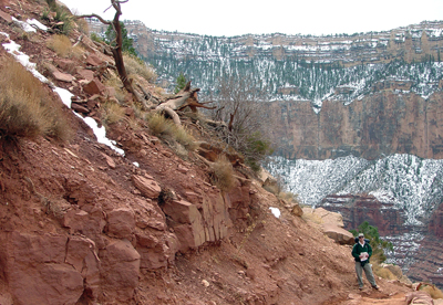
View of the Hermit Shale along the South Kaibab Trail on Grand Canyon's South Rim. In the distance, the Hermit Shale is mostly covered by forests (and snow) below the massive cliff of the overlying Coconino Sandstone and the underlying Supai Group.
Age:
Permian, Early*
Leonardian*
Early Permian - 280 million years (age used by National Park Service; Mathis and Bowman, 2005)
Geologic Province:
Plateau sedimentary province*
Salton basin*
Great Basin province*
Areal Extent:
AZ(n)*
CA(se)*
NV(se)*
UT(s)*
Type Locality:
Not designated. Named for Hermit basin, Coconino Co., AZ (Noble, 1923).
Unit Name History:
Named Hermit Shale (Noble, 1923). Revised; Redescribed as Hermit Formation (McNair, 1951). Revised (McKee, 1975). Redescribed as Hermit Schist in CA; Areal limits; Revised (Hamilton, 1982). Redescribed as Hermit Formation; Areal limits; Revised (Blakey, 1990). Areal limits; Overview; Redescribed as Hermit Formation in AZ, NV, UT (Billingsley, 1997).
Hermit Formation (Lower Permian)—Red, slope-forming, fine-grained, thin-bedded siltstone and sandstone. Upper part contains red and white, massive, low-angle cross-bedded calcareous sandstone and siltstone beds in western one-quarter of map area. Siltstone beds are dark red and crumbly, and fill shallow erosion channels that are widespread. Siltstone beds form recesses between thicker sandstone beds; locally contains poorly preserved plant fossils in channel fills in lower part of formation. Sandstone beds thicken and thin laterally either as channel fill or low sand dune accumulations. Sandstone bleaches to yellow-white color in vicinity of breccia pipes throughout map area, and at upper contact with Coconino Sandstone or Toroweap Formation in western half of map area. Unconformably overlies Esplanade Sandstone. Dark-red, platy, thin-bedded siltstone of Hermit Formation fills channels as much as 60 ft (16 m) deep eroded into the underlying Esplanade in eastern part of map area, and as much as 130 ft (40 m) deep in Havasu Canyon area, south-central part of map area. Erosional relief is generally less than 10 ft (3 m) in northeastern part of map area. About 260 ft (80 m) thick along eastern edge of map area, increasing to about 850 ft (260 m) at western edge of map area.
Noble, L.F., 1923, A section of the Paleozoic formations of the Grand Canyon at the Bass Trail, IN Shorter contributions to general geology, 1922: U.S. Geological Survey Professional Paper, 131-B, p. B23-B73.
McNair, A.H., 1951, Paleozoic stratigraphy of part of northwestern Arizona: American Association of Petroleum Geologists Bulletin, v. 35, no. 3, p. 503-541.
McKee, E.H., 1975, The Supai Group; subdivision and nomenclature, IN Contributions to stratigraphy: U.S. Geological Survey Bulletin, 1395-J, p. J1-J7.
Hamilton, Warren, 1982, Structural evolution of the Big Maria Mountains, northeastern Riverside County, southeastern California, IN Frost, E.G., and Martin, D.L., editors, Mesozoic-Cenozoic tectonic evolution of the Colorado River region, California, Arizona, and Nevada; Anderson-Hamilton volume: San Diego, CA, Cordilleran Publishers, p. 1-27, Published in conjunction with the Geological Society of America symposium and field trip, April, 1982.
Blakey, R.C., 1990, Stratigraphy and geologic history of Pennsylvanian and Permian rocks, Mogollon Rim region, central Arizona and vicinity: Geological Society of America Bulletin, v. 102, no. 9, p. 1189-1217.
Billingsley, G.H., 1997, The Permian clastic sedimentary rocks of northwestern
Arizona, IN Maldonado, Florian, and Nealey, L.D., editors, Geologic studies
in the Basin and Range-Colorado Plateau transition in southeastern Nevada,
southwestern Utah, and northwestern Arizona, 1995: U.S. Geological Survey
Bulletin, 2153, p. 106-124.
Billingsley, George H., 2000, Geologic Map of the Grand Canyon 30' by 60' Quadrangle, Coconino and Mohave Counties, Northwestern Arizona: U.S. Geological Survey Geologic Investigation Series I-2688, Available on-line at: http://pubs.usgs.gov/imap/i-2688/.).
Mathis, A. and Bowman, C., 2005, What's in a number? Numeric ages for rocks exposed within the Grand Canyon, Part 2: Nature Notes ( Grand Canyon National Park ), v. 21, no. 2, p. 1-5.