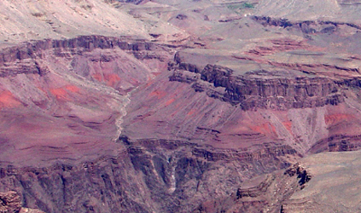
Hakatai Shale
Hakatai Shale*

Hakatai Shale (red, sope-forming shale) crops out between the Shinumo Quartzite (gray cliffs above) and the Bass Formation (layered gray cliffs above the the Inner Gorge Vishnu Basement Rocks) near Phantom Ranch in the Grand Canyon.
Precambrian*
Proterozoic, Middle*
Mesoproterozoic (1100 to 1200 million years old)
(age used by National Park Service; Mathis and Bowman, 2005)
Southern Rocky Mountain region*
AZ(n)*
Type Locality:
Not designated. Named for Hakatai Canyon, north side of Colorado River,
Shinumo quad, Coconino Co, AZ (Noble, 1914).
Named as a formation in Unkar Group of Grand Canyon Series (Noble, 1914). Assigned to Unkar Group of Grand Canyon Supergroup (Elston, Scott, 1976). Age modified (Elston, 1989b). Overview (Elston, 1989a).
Hakatai Shale—Orange-red, purple, and red mudstone, shale, and sandstone. Forms an upper cliff unit, a middle slope unit, and a lower slope unit. Upper cliff unit consists of pale-purple or lavender, fine- to coarse-grained, thin- to mediumbedded, cross-bedded sandstone. Forms gradational contact with underlying middle slope unit at distinct color change from purple to bright red. Middle slope unit is the most distinctive red-bed unit in the Grand Canyon, consisting of reddish-orange, thin-bedded, fine-grained mudstone, siltstone and sandy siltstone; includes nonred, spherical reduction spots (“freckles”) less than 10 cm in diameter. Gradational contact with underlying lower slope unit arbitrarily placed at red to purple color change. Lower slope unit consists of purple to reddish-purple, thin-bedded to laminated, fine-grained mudstone, siltstone, and sandy siltstone. Mudcracks, ripple marks, and tabular-planar cross-bedding are common in all units. Gradational contact with underlying Bass Formation in eastern part of map area; sharp but conformable contact in central part of map area. Overall thickness varies from about 445 ft (135 m) in eastern part of map area to nearly 985 ft (300 m) in Hakatai Canyon, central part of map area.
Noble, L.F., 1914, The Shinumo quadrangle, Grand Canyon district, Arizona: U.S. Geological Survey Bulletin, 549, 100 p., (incl. geologic map, scale 1:48,000).
Elston, D.P. and Scott, G.R., 1976, Unconformity at the Cardenas-Nankoweap contact (Precambrian), Grand Canyon Supergroup, northern Arizona: Geological Society of America Bulletin, v. 87, no. 12, p. 1763-1772.
Elston, D.P., 1989, Middle and late Proterozoic Grand Canyon Supergroup, Chapter 9, IN Elston, D.P., Billingsley, G.H., and Young, R.A., editors, Geology of Grand Canyon, northern Arizona (with Colorado river guides); Lees Ferry to Pierce Ferry, Arizona; guidebook to field trips T115 and T315: International Geological Congress, 28th, Field Trip Guidebook, T115, T315, Washington, DC, 1989, p. 94-105.
Elston, D.P., 1989, Grand Canyon Supergroup, northern Arizona; stratigraphic
summary and preliminary paleomagnetic correlations with parts of other
North American Proterozoic successions, IN Jenney, J.P., and Reynolds,
S.J., editors, Geologic evolution of Arizona: Arizona Geological Society
Digest, v. 17, p. 259-272.
Billingsley, George H., 2000, Geologic Map of the Grand Canyon 30' by 60' Quadrangle, Coconino and Mohave Counties, Northwestern Arizona: U.S. Geological Survey Geologic Investigation Series I-2688, Available on-line at: http://pubs.usgs.gov/imap/i-2688/.).
Mathis, A. and Bowman, C., 2005, What's in a number? Numeric ages for rocks exposed within the Grand Canyon, Part 2: Nature Notes ( Grand Canyon National Park ), v. 21, no. 2, p. 1-5.