Entrada Formation
Entrada Sandstone of San Rafael Group (AZ*,CO*,NM*,UT*)
Entrada Sandstone (NM,UT,WY)
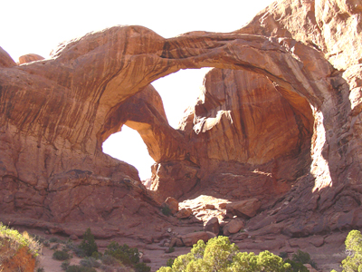
The Entrada Sandstone is responsible for many of the arches and unique landscape features in Arches National Park.
Jurassic, late Middle*
Callovian, early*
Callovian, middle*
Anadarko basin*
Black Mesa basin*
Denver basin*
Great Basin province
Green River basin*
Las Vegas-Raton basin
Paradox basin*
Piceance basin*
Plateau sedimentary province*
San Juan basin*
Sierra Grande uplift*
AZ(ne)*
CO*
NM(nw)*
UT(se)*
WY
Type Locality:
Type section: Entrada Point, for which unit is named, northern San Rafael
Swell, Emery Co., UT (Gilluly and Reeside, 1928).
Principal reference section measured at Pine Creek in SW/4 sec. 29 and
SE/4 sec. 30, T. 24 S., R. 3 E., Garfield Co., UT (Peterson, 1988).
(alphabetical): Cannonville Member (UT), Cow Springs Member (AZ*), Dewey Bridge Member (CO*,UT*), Escalante Member (UT), Exeter Member (NM), Gunsight Butte Member (UT), Iyanbito Member (NM*), Moab Member (CO*,UT*) or Moab Tongue (CO*,UT*), Red Mesa Member (AZ,NM,UT), Slick Rock Member (CO*,UT*).
Named as 1 of 4 formations of San Rafael Group (Gilluly and Reeside, 1928). Areal limits; Overview (Gregory and Moore, 1931). Revised (Goldman and Spencer, 1941). Revised; Areal limits (Mackin, 1947). Revised (Eckel, 1949; Harshbarger and others, 1951). Areal limits (McLaughlin, 1954; Mackin, 1954). Overview (Harshbarger and others, 1957). Areal limits (Griggs and Read, 1959; Johnson, 1959). Revised (Johnson and Baltz, 1960). Revised; Overview (Wright and others, 1962). Divided into Gunsight Butte, Cannonville, and Escalante members (Thompson and Stokes, 1970). Mapped 1:24k in southeast Ouray Co, CO (Luedke, 1972). Revised; Areal limits (Green, 1974). Mapped 1:24k in southwest Moffat Co, CO (Rowley and Hansen, 1979). Not used (Barnes, 1983). Areal limits (O'Sullivan, 1983). Revised; Areal limits (Lucas and others, 1985). Not used (Scott, 1986). Overview (Lucas and others, 1987). Revised; Principal reference; Overview (Peterson, 1988). Revised (Condon and Huffman, 1988). Figure (GNU Staff, 1989). Areal limits (Condon, 1992).
References
Gilluly, James and Reeside, J.B., Jr., 1928, Sedimentary rocks of the San Rafael Swell and some adjacent areas in eastern Utah, IN Shorter contributions to general geology, 1927: U.S. Geological Survey Professional Paper, 150-D, p. D61-D110.
Gregory, H.E. and Moore, R.C., 1931, The Kaiparowits region, a geographic and geologic reconnaissance of parts of Utah and Arizona: U.S. Geological Survey Professional Paper, 164, 161 p.
Goldman, M.I. and Spencer, A.C., 1941, Correlation of Cross' La Plata sandstone, southwestern Colorado: American Association of Petroleum Geologists Bulletin, v. 25, no. 9, p. 1745-1767.
Mackin, J.H., 1947, Some structural features of the intrusions in the Iron Springs district [Utah]: Utah Geological Society, Guidebook to the geology of Utah, no. 2, 62 p.
Eckel, E.B., 1949, Geology and ore deposits of the La Plata district, Colorado: U.S. Geological Survey Professional Paper, 219, 179 p.
Harshbarger, J.W., Repenning, C.A. and Jackson, R.L., 1951, Jurassic stratigraphy of the Navajo country, IN Smith, C.T., and Silver, Caswell, editors, Guidebook of the San Juan basin [covering south and west sides], New Mexico and Arizona: New Mexico Geological Society Guidebook, no. 2, p. 95-99, 103.
McLaughlin, T.G., 1954, Geology and ground-water resources of Baca County, Colorado: U.S. Geological Survey Water-Supply Paper, 1256, 232 p.
Mackin, J.H., 1954, Geology and iron ore deposits of the Granite Mountain area, Iron County, Utah: U.S. Geological Survey Miscellaneous Field Studies Map, MF-l4, 1 sheet, scale 1:12,000.
Harshbarger, J.W., Repenning, C.A. and Irwin, J.H., 1957, Stratigraphy of the uppermost Triassic and the Jurassic rocks of the Navajo country: U.S. Geological Survey Professional Paper, 291, 74 p.
Griggs, R.L. and Read, C.B., 1959, Revisions in stratigraphic nomenclature in Tucumcari-Sabinoso area, northeastern New Mexico: American Association of Petroleum Geologists Bulletin, v. 43, no. 8, p. 2003-2007.
Johnson, R.B., 1959, Geology of the Huerfano Park area, Huerfano and Custer Counties, Colorado, IN Contributions to general geology, 1957: U.S. Geological Survey Bulletin, 1071-D, p. D87-D119.
Johnson, R.B. and Baltz, E.H., 1960, Probable Triassic rocks along eastern front of Sangre de Cristo Mountains, south-central Colorado: American Association of Petroleum Geologists Bulletin, v. 44, no. 12, p. 1895-1902.
Wright, J.C., Shawe, D.R. and Lohman, S.W., 1962, Definition of members of Jurassic Entrada Sandstone in east-central Utah and west-central Colorado: American Association of Petroleum Geologists Bulletin, v. 46, no. 11, p. 2057-2070.
Thompson, A.E. and Stokes, W.L., 1970, Stratigraphy of the San Rafael Group, southwest and south central Utah: Utah Geological and Mineral Survey Bulletin, no. 87, 53 p.
Luedke, R.G., 1972, Geologic map of the Wetterhorn Peak quadrangle, Colorado: U.S. Geological Survey Geologic Quadrangle Map, GQ-1011, 1 sheet, scale 1:24,000.
Green, M.W., 1974, The Iyanbito Member (a new stratigraphic unit) of the Jurassic Entrada Sandstone, Gallup-Grants area, New Mexico, IN Contributions to stratigraphy: U.S. Geological Survey Bulletin, 1395-D, p. D1-D12.
Rowley, P.D. and Hansen, W.R., 1979, Geologic map of the Plug Hat quadrangle, Moffat County, Colorado: U.S. Geological Survey Geologic Quadrangle Map, GQ-1514, 1 sheet, scale 1:24,000.
O'Sullivan, R.B., 1983, Stratigraphic sections of Middle Jurassic San Rafael Group and related rocks from Dewey Bridge, Utah to Uravan, Colorado: U.S. Geological Survey Oil and Gas Investigations Chart, OC-124, 1 sheet.
Barnes, V.E., 1983, Geologic atlas of Texas, Tucumcari Sheet; Henryk Bronislaw Stenzel memorial edition: University of Texas-Austin, Bureau of Economic Geology, 1 sheet, scale 1:250,000.
Lucas, S.G., Kietzke, K.K. and Hunt, A.P., 1985, The Jurassic System in east-central New Mexico, IN Lucas, S.G., ed., Santa Rosa-Tucumcari region: New Mexico Geological Society Guidebook, no. 36, p. 213-242.
Scott, G.R., 1986, Geologic and structure contour map of the Springer 30' x 60' quadrangle, Colfax, Harding, Mora, and Union Counties, New Mexico: U.S. Geological Survey Miscellaneous Investigations Series Map, I-1705, 2 sheets, scale 1:100,000.
Lucas, S.G., Hunt, A.P. and Hayden, S.N., 1987, Type section of Exeter Member of Entrada Sandstone, Jurassic of northeastern New Mexico, IN Lucas, S.G., and Hunt, A.P., editors, Northeastern New Mexico: New Mexico Geological Society Guidebook, no. 38, p. 17-22.
Peterson, Fred, 1988, Stratigraphy and nomenclature of Middle and Upper Jurassic rocks, western Colorado Plateau, Utah and Arizona, IN Revisions to stratigraphic nomenclature of Jurassic and Cretaceous rocks of the Colorado Plateau: U.S. Geological Survey Bulletin, 1633-B, p. B13-56.
Condon, S.M. and Huffman, A.C., Jr., 1988, Revisions in nomenclature of Middle Jurassic Wanakah Formation, northwest New Mexico and northeast Arizona, IN Revisions to stratigraphic nomenclature of Jurassic and Cretaceous rocks of the Colorado Plateau: U.S. Geological Survey Bulletin, 1633-A, p. A1-A12.
Condon, S.M., 1992, Geologic framework of pre-Cretaceous rocks in the Southern Ute Indian Reservation and adjacent areas, southwestern Colorado and northwestern New Mexico, IN Geology and mineral resources of the Southern Ute Indian Reservation: U.S. Geological Survey Professional Paper, 1505-A, p. A1-A56.
Doelling, Hellmut H., 2002, Geologic map of the Fisher Towers 7.5' Quadrangle, Grand County, Utah: Utah Geological Survey, Map 183, 22 p., 1 sheet, scale1:24,000.
Doelling, Hellmut H., 2000, Geology of Arches National Park, Grand County, Utah. In, Geology of Utah's parks and monuments Sprinkel, Douglas A., Chidsey, Thomas C., Jr., Anderson, Paul B., editors, Utah Geological Association Publication, v. 28, p. 11-36.
Milligan, Mark R., 2002, Geology of Goblin Valley State Park, Utah. In, Geology of Utah's parks and monuments Sprinkel, Douglas A., Chidsey, Thomas C., Jr., Anderson, Paul B., editors, Utah Geological Association Publication, v. 28, p. 421-431.
Lucas, Spencer G., and Anderson, Orin J., 1997, The Jurassic San Rafael Group, Four Corners region: In, Mesozoic geology and paleontology of the Four Corners region; Anderson, Orin J., Kues, Barry S., and Lucas, Spencer G., editors, New Mexico Geological Society Guidebook, vol.48, p. 115-132.
Anderson, Orin J., and Lucas, Spencer G., 1994, Middle Jurassic stratigraphy, sedimentation and paleogeography in the Southwestern United States In, Pangea; global environments and resources; Embry, A.F., Beauchamp, B., and Glass, D. J., Canadian Society of Petroleum Geologists Memoir, v. 17, p. 255-264.
Lucas, Spencer G., Heckert, Andrew B., Anderson, Orin J., 2001, The Middle Jurassic Entrada Sandstone near Gallup, New Mexico., discussion [modified]: The Mountain Geologist, v. 38, no. 4, p. 225-227.
Robertson, Jacques F., O'Sullivan, Robert B., 2001, The Middle Jurassic Entrada Sandstone near Gallup, New Mexico., reply [modified]: The Mountain Geologist, v. 38, no. 4, p. 228-231.
Robertson, Jacques F., and O'Sullivan, Robert B., 2001, The Middle Jurassic Entrada Sandstone near Gallup, New Mexico The Mountain Geologist, v. 38, no. 2, p. 53-69.
Cruikshank, Kenneth M., Aydin, Atilla, 1995, Unweaving the joints in Entrada Sandstone, Arches National Park, Utah, U.S.A.: Journal of Structural Geology, v. 17, no. 3, p. 409-421.