Dakota Sandstone
Dakota Sandstone (AZ*,CO*,IA*,KS*,MN*,MT*,NE*,NM*,ND*,OK*,SD*,TX*,UT*,WY*)
Dakota Formation (IA,KS*,MN*,NE*,NM*,SD,UT*,WY)
Dakota Group (CO*,KS*,NE*,NM,ND)
Dakota Conglomerate (UT*)
Cretaceous, Early* (local)
Albian, late* (local)
Cretaceous, Late*
Cenomanian*
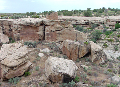
Dakota Sandstone forms the canyon caprock at Hovenweep National Monument.
Geologic Province:
Basin and Range province*
Black Mesa basin*
Central Kansas uplift*
Denver basin*
Eagle basin*
Green River basin*
Iowa shelf*
Las Animas arch*
Las Vegas-Raton basin*
North Park basin
Orogrande basin*
Palo Duro basin*
Paradox basin*
Piceance basin*
Plateau sedimentary province*
Powder River basin*
San Juan basin*
Sierra Grande uplift*
Sioux uplift*
South Park basin*
Sweetgrass arch*
Uinta basin*
Williston basin*
AZ*
CO*
IA*
KS*
MN*
MT*
NE*
NM*
ND*
OK*
SD*
TX*
UT*
WY*
Not originally designated; unit occurs in hills in back of town of Dakota, for which it was named, Dakota Co., NE (Meek and Hayden, 1862). "Type locality" designated in Missouri River Bluffs, 1 mi southeast of Homer, NE/4 sec. 13, T. 27 N., R. 4 E., Dakota Co., NE (Condra and Reed, 1943).
Group rank (alphabetical): Cedar Mountain Formation (CO) or Cedar Mountain Shale (CO), Fall River Formation (ND) or Fall River Sandstone (NE), Fuson Formation (ND) or Fuson Shale (NE), Lakota Formation (NE,ND), Lytle Formation (CO*), Mesa Rica Sandstone (NM), Mowry Formation (ND), Muddy Sandstone (CO,NM), Naturita Formation (CO), Newcastle Formation (ND) or Newcastle Sandstone (NE), Omadi Sandstone (NE), Pajarito Formation (NM), Plainview Formation (CO), Romeroville Sandstone (CO,NM,OK), Skull Creek Formation (ND) or Skull Creek Shale (CO,NE), South Platte Formation (CO*,WY*).
Named (Meek and Hayden, 1862). Areal limits (Eldridge, 1888). Not used; Overview (Hill, 1901). Revised (Darton, 1901). Areal limits (Willis, 1902; Lee, 1902). Revised (Stose, 1912; Finlay, 1916; Winchester, 1920; Collier, 1922; Rubey and Bass, 1925). Areal limits (Gregory and Moore, 1931). Revised; Areal limits (Rubey, 1931). Revised (Plummer and Romary, 1942). Revised; Areal limits; Overview (Condra and Reed, 1943). Revised (Stokes and Phoenix, 1948). Areal limits (Gregory, 1950). Revised (Waage, 1953; 1955). Overview (Repenning and Page, 1956). Mapped 1:24k in Jefferson Co, CO (Van Horn, 1957). Revised (Freeman and Hilpert, 1957; Baldwin and Muehlberger, 1959; Young, 1959). Not used (Averitt, 1962). Overview (Kottlowski, 1963). Revised (MacKenzie, 1965; Owen, 1966; Smith, 1967). Overview (MacKenzie, 1971). Areal limits (Segerstrom and Young, 1972). Revised (Landis and others, 1973). Overview; Areal limits (Taylor, 1975). Age modified (Hook and Cobban, 1977). Overview (Scott and others, 1978; Bryant, 1979). Mapped 1:24k in Moffat Co, CO (Rowley and Hansen, 1979). Areal limits; Overview (Bryant and others, 1981). Areal limits (Merewether and Cobban, 1981). Areal limits; Mapped 1:250k in Harding, Union, San Miguel, Quay Cos, NM (Barnes, 1983). Revised (Hook and others, 1983; Munter and others, 1983; Owen and others, 1984). Overview (Tschudy and others, 1984). Areal limits (Baltz and O'Neill, 1984; Ulrich and others, 1984). Redescribed; Areal limits (Johnson, 1984). Age modified; Overview (Baltz and O'Neill, 1986). Revised (Kues and Lucas, 1987; Aubrey, 1988). Areal limits (Moore and others, 1988). Biostratigraphic dating (Cobban, 1988; Cobban and Kennedy, 1989; Cobban and Hook, 1989). Overview (Molenaar and Cobban, 1991). Redescribed; Overview (Hintze and others, 1994).
REFERENCES
Meek, F.B. and Hayden, F.V., 1862, Descriptions of new Lower Silurian, (Primordial), Jurassic, Cretaceous, and Tertiary fossils, collected in Nebraska Territory..., with some remarks on the rocks from which they were obtained: Academy of Natural Sciences of Philadelphia Proceedings, v. 13, p. 415-447.
Eldridge, G.H., 1888, On some stratigraphical and structural features of the country about Denver, Colorado: Colorado Scientific Society Proceedings, v. 3, pt. 1, p. 86-118.
Hill, R.T., 1901, Geography and geology of the Black and Grand Prairies, Texas: U.S. Geological Survey Annual Report, 21, pt. 7, 666 p.
Willis, Bailey, 1902, Stratigraphy and structure, Lewis and Livingston ranges, Montana: Geological Society of America Bulletin, v. 13, p. 305-352.
Lee, W.T., 1902, The Morrison shales of southern Colorado and northern New Mexico: Journal of Geology, v. 10, p. 36-58.
Stose, G.W., 1912, Description of the Apishapa quadrangle [Colorado]: U.S. Geological Survey Geologic Atlas of the United States, Apishapa folio, no. 186, 12 p.
Finlay, G.I., 1916, Description of the Colorado Springs quadrangle, Colorado: U.S. Geological Survey Geologic Atlas of the United States, Colorado Springs folio, no. 203, 17 p.
Winchester, D.E., 1920, Geology of Alamosa Creek Valley, Socorro County, New Mexico, with special reference to the occurrence of oil and gas, IN Contributions to economic geology, 1920; Part 2, Mineral fuels: U.S. Geological Survey Bulletin, 716-A, p. 1-15.
Collier, A.J., 1922, The Osage oil field, Weston County, Wyoming, IN Contributions to economic geology: U.S. Geological Survey Bulletin, 736-D, p. 71-110.
Rubey, W.W. and Bass, N.W., 1925, The geology of Russell County, Kansas, with special reference to oil and gas resources: Kansas Geological Survey Bulletin, no. 10, pt. 1, p. 46-47.
Gregory, H.E. and Moore, R.C., 1931, The Kaiparowits region, a geographic and geologic reconnaissance of parts of Utah and Arizona: U.S. Geological Survey Professional Paper, 164, 161 p.
Rubey, W.W., 1931, Lithologic studies of fine-grained Upper Cretaceous sedimentary rocks of the Black Hills region, IN Shorter contributions to general geology, 1930: U.S. Geological Survey Professional Paper, 165-A, p. A1-A54.
Plummer, N. and Romary, J.F., 1942, Stratigraphy of the pre-Greenhorn Cretaceous beds of Kansas: Kansas Geological Survey Bulletin, no. 41, pt. 9, p. 313-348.
Condra, G.E. and Reed, E.C., 1943, The geological section of Nebraska: Nebraska Geological Survey Bulletin, no. 14, 82 p., Revised 1959.
Stokes, W.L. and Phoenix, D.A., 1948, Geology of the Egnar-Gypsum Valley area, San Miguel and Montrose Counties, Colorado: U.S. Geological Survey Oil and Gas Investigations Map, OM-93, 1 sheet, scale 1:48,000.
Gregory, H.E., 1950, Geology and geography of the Zion [National] Park region, Utah and Arizona: U.S. Geological Survey Professional Paper, 220, 200 p.
Waage, K.M., 1953, Refractory clay deposits of south-central Colorado: U.S. Geological Survey Bulletin, 993, 104 p.
Waage, K.M., 1955, Dakota group in northern Front Range foothills, Colorado, IN Shorter contributions to general geology, 1955-57: U.S. Geological Survey Professional Paper, 274-B, p. B15-B51.
Repenning, C.A. and Page, H.G., 1956, Late Cretaceous stratigraphy of Black Mesa, Navajo and Hopi Indian Reservations, Arizona: American Association of Petroleum Geologists Bulletin, v. 40, no. 2, p. 255-294.
Freeman, V.L. and Hilpert, L.S., 1957, Stratigraphy of the Morrison formation in part of northwestern New Mexico, IN Contributions to the geology of uranium, 1955: U.S. Geological Survey Bulletin, 1030-J, p. J309-J334.
Van Horn, Richard, 1957, Bedrock geology of the Golden quadrangle, Colorado: U.S. Geological Survey Geologic Quadrangle Map, GQ-103, 1 sheet, scale 1:24,000.
Young, R.G., 1959, Cretaceous deposits of the Grand Junction area, Garfield, Mesa, and Delta Counties, Colorado, IN Symposium on Cretaceous rocks of Colorado and adjacent areas; Washakie, Sand Wash, and Piceance basins: Rocky Mountain Association of Geologists Field Conference Guidebook, no. 11, p. 1-8.
Baldwin, Brewster and Muehlberger, W.R., 1959, Geologic studies of Union County, New Mexico: New Mexico Bureau of Mines and Mineral Resources Bulletin, no. 63, 171 p.
Averitt, Paul, 1962, Geology and coal resources of the Cedar Mountain quadrangle, Iron County, Utah: U.S. Geological Survey Professional Paper, 389, 72 p.
Kottlowski, F.E., 1963, Paleozoic and Mesozoic strata of southwestern and south-central New Mexico: New Mexico Bureau of Mines and Mineral Resources Bulletin, no. 79, 100 p.
MacKenzie, D.B., 1965, Depositional environments of Muddy Sandstone, western Denver basin, Colorado: American Association of Petroleum Geologists Bulletin, v. 49, no. 2, p. 186-206.
Owen, D.E., 1966, Nomenclature of Dakota Sandstone (Cretaceous) in San Juan basin, New Mexico and Colorado: American Association of Petroleum Geologists Bulletin, v. 50, no. 5, p. 1023-1028.
Smith, C.T., 1967, Jurassic stratigraphy of the north flank of the Zuni Mountains, IN Trauger, Fred, ed., Guidebook of Defiance-Zuni-Mt. Taylor region [Arizona and New Mexico]: New Mexico Geological Society Guidebook, no. 18, p. 132-137.
MacKenzie, D.B., 1971, Post-Lytle Dakota Group on west flank of Denver basin, Colorado: The Mountain Geologist, v. 8, no. 3, p. 91-131.
Segerstrom, K. and Young, E.J., 1972, General geology of the Hahns Peak and Farwell Mountain quadrangles, Routt County, Colorado, with a discussion of Upper Triassic and pre-Morrison Jurassic rocks by G.N. Pipiringos: U.S. Geological Survey Bulletin, 1349, 63 p., (incl. geologic map, scale 1:24,000).
Landis, E.R., Dane, C.H. and Cobban, W.A., 1973, Stratigraphic terminology of the Dakota Sandstone and Mancos Shale, west-central New Mexico, IN Contributions to stratigraphy: U.S. Geological Survey Bulletin, 1372-J, p. J1-J44.
Taylor, R.B., 1975, Geologic map of the Bottle Pass quadrangle, Grand County, Colorado: U.S. Geological Survey Geologic Quadrangle Map, GQ-1224, 1 sheet, scale 1:24,000.
Hook, S.C. and Cobban, W.A., 1977, Pycnodonte newberryi (Stanton); common guide fossil in Upper Cretaceous of New Mexico; Report of progress, July 1, 1976 to June 30, 1977: New Mexico Bureau of Mines and Mineral Resources Annual Report, p. 48-54.
Scott, G.R., Taylor, R.B., Epis, R.C. and Wobus, R.A., 1978, Geologic map of the Pueblo 1 degrees by 2 degrees quadrangle, south-central Colorado: U.S. Geological Survey Miscellaneous Investigations Series Map, I-1022, 2 sheets, scale 1:250,000, (Reprinted 1981) Bryant, B.H., 1979, Geology of the Aspen 15-minute quadrangle, Pitkin and Gunnison Counties, Colorado: U.S. Geological Survey Professional Paper, 1073, 146 p.
Rowley, P.D. and Hansen, W.R., 1979, Geologic map of the Plug Hat quadrangle, Moffat County, Colorado: U.S. Geological Survey Geologic Quadrangle Map, GQ-1514, 1 sheet, scale 1:24,000.
Bryant, B.H., McGrew, L.W. and Wobus, R.A., 1981, Geologic map of the Denver 1 degrees by 2 degrees quadrangle, north-central Colorado; Sheet 1, Geology; Sheet 2, Structure: U.S. Geological Survey Miscellaneous Investigations Series Map, I-1163, 2 sheets, scale 1:250,000, Supersedes U.S. Geological Survey Open-File Report OF-75-340 and OF-78-397.
Merewether, E.A. and Cobban, W.A., 1981, Mid-Cretaceous formations in eastern South Dakota and adjoining areas; stratigraphic, paleontologic, and structural interpretation: Iowa Geological Survey Bureau Guidebook Series, no. 4, p. 43-56.
Munter, J.A., Ludvigson, G.A. and Bunker, B.J., 1983, Hydrogeology and stratigraphy of the Dakota Formation in northwest Iowa: Iowa Geological Survey Bureau Water-Supply Bulletin, no. 13, 55 p.
Hook, S.C., Molenaar, C.M. and Cobban, W.A., 1983, Stratigraphy and revision of nomenclature of upper Cenomanian to Turonian (Upper Cretaceous) rocks of west-central New Mexico: New Mexico Bureau of Mines and Mineral Resources Circular, no. 185, p. 7-28.
Barnes, V.E., 1983, Geologic atlas of Texas, Tucumcari Sheet; Henryk Bronislaw Stenzel memorial edition: University of Texas-Austin, Bureau of Economic Geology, 1 sheet, scale 1:250,000.
Johnson, B.T., 1984, Depositional environment of the Iron Springs Formation, Gunlock, Utah: Brigham Young University Geology Studies, v. 31, pt. 1, p. 29-46.
Baltz, E.H. and O'Neill, J.M., 1984, Geologic map and cross sections of the Mora River area, Sangre de Cristo Mountains, Mora County, New Mexico: U.S. Geological Survey Miscellaneous Investigations Series Map, I-1456, 2 sheets, scale 1:24,000.
Ulrich, G.E. (compiler), Billingsley, G.H. (compiler), Hereford, Richard (compiler), Wolfe, E.W. (compiler), Nealey, L.D. (compiler) and Sutton, R.L. (compiler), 1984, Maps showing geology, structure, and uranium deposits of the Flagstaff 1 degrees by 2 degrees quadrangle, Arizona: U.S. Geological Survey Miscellaneous Investigations Series Map, I-1446, 2 sheets, scale 1:250,000.
Tschudy, R.H., Tschudy, B.D. and Craig, L.C., 1984, Palynological evaluation of Cedar Mountain and Burro Canyon Formations, Colorado Plateau: U.S. Geological Survey Professional Paper, 1281, 24 p.
Owen, D.E., Walters, L.J., Jr. and Beck, R.G., 1984, The Jackpile Sandstone Member of the Morrison Formation in west-central New Mexico; a formal definition: New Mexico Geology, v. 6, no. 3, p. 45-52.
Baltz, E.H. and O'Neill, J.M., 1986, Geologic map and cross section of the Sapello River area, Sangre de Cristo Mountains, Mora and San Miguel Counties, New Mexico: U.S. Geological Survey Miscellaneous Investigations Series Map, I-1575, 2 sheets, scale 1:24,000, Supersedes U.S. Geological Survey Open-File Report OF-80-398.
Kues, B.S. and Lucas, S.G., 1987, Cretaceous stratigraphy and paleontology in the Dry Cimarron Valley, New Mexico, Colorado, and Oklahoma, IN Lucas, S.G., and Hunt, A.P., editors, Northeastern New Mexico: New Mexico Geological Society Guidebook, no. 38, p. 167-198.
Cobban, W.A., 1988, Tarrantoceras Stephenson and related ammonoid genera from Cenomanian (Upper Cretaceous) rocks in Texas and the Western Interior of the United States: U.S. Geological Survey Professional Paper, 1473, 51 p.
Aubrey, W.M., 1988, The Encinal Canyon Member, a new member of the Upper Cretaceous Dakota Sandstone in the southern and eastern San Juan basin, New Mexico, IN Revisions to stratigraphic nomenclature of Jurassic and Cretaceous rocks of the Colorado Plateau: U.S. Geological Survey Bulletin, 1633-C, p. C57-C69 Moore, S.L., Foord, E.E. and Meyer, G.A., 1988, Geologic and aeromagnetic map of a part of the Mescalero Apache Indian Reservation, Otero County, New Mexico: U.S. Geological Survey Miscellaneous Investigations Series Map, I-1775, 1 sheet, scale.
Cobban, W.A. and Kennedy, W.J., 1989, Observations on the Cenomanian (Upper Cretaceous) ammonite Calycoceras (Calycoceras) obrieni Young, 1957, from Arizona and New Mexico, IN Sando, W.J., ed., Shorter contributions to paleontology and stratigraphy: U.S. Geological Survey Bulletin, 1881-C, p. C1-C4.
Cobban, W.A. and Hook, S.C., 1989, Mid-Cretaceous molluscan record from west-central New Mexico, IN Anderson, O.J., and others, editors, Southeastern Colorado Plateau: New Mexico Geological Society Guidebook, no. 40, p. 247-264.
Molenaar, C.M. and Cobban, W.A., 1991, Middle Cretaceous stratigraphy on the south and east sides of the Uinta basin, northeastern Utah and northwestern Colorado, IN Evolution of sedimentary basins; Uinta and Piceance basins: U.S. Geological Survey Bulletin, 1787-P, p. P1-P34.
Hintze, L.F., Anderson, R.E. and Embree, G.F., 1994, Geologic map of the Motoqua and Gunlock quadrangles, Washington County, Utah: U.S. Geological Survey Miscellaneous Investigations Series Map, I-2427, 7 p., 1 sheet, scale 1:24,000.
Kirkland, James I., Cifelli, Richard L., Britt, Brooks B., Burge, Donald L., DeCourten, Frank L., Eaton, Jeffrey G., Parrish, J Michael, 1999, Distribution of vertebrate faunas in the Cedar Mountain Formation, east-central Utah: In, Vertebrate paleontology in Utah, Gillette, David D., ed., Utah Geological Survey, Miscellaneous Publication, v. 99-1, p. 201-217.
Noe, David C., 2002, Greater Piceance plays., Dakota Sandstone, Cedar Mountain Formation, and Morrison Formation [modified]: In, Atlas of major Rocky Mountain gas reservoirs, Hjellming, Carol A. (ed.), New Mexico Bureau of Mines and Mineral Resources, Socorro, NM.
Roberts, Laura N R., 2003, Structure contour map of the top of the Dakota Sandstone, Uinta-Piceance Province, Utah and Colorado: Petroleum systems and geologic assessment of oil and gas in the Uinta-Piceance Province, Utah and Colorado: U. S. Geological Survey Digital Data Series, Report: DDS-0069-B, 11 p.
Hylland, Michael D., 2001, Suggested revisions to lithostratigraphic
boundaries of the Upper Cretaceous Dakota Formation on the Kolob Terrace,
Southwest Utah: In, The geologic transition, high plateaus to Great Basin.,
a symposium and field guide., the Mackin volume;
Erskine, M C., Faulds, James E., Bartley, John M., Rowley, Peter D., editors,
American Association of Petroleum, Pacific Section, Guidebook, v. 78,
p. 424-425.
Ulicny, David, 1999, Sequence stratigraphy of the Dakota Formation (Cenomanian), southern Utah., interplay of eustacy and tectonics in a foreland basin: Sedimentology, v. 46, no. 5, p. 807-836.
Ravn, Robert L. and Witzke, Brian J., 1994, The Mid-Cretaceous boundary
in the Western Interior Seaway, central United States; implications of
palynostratigraphy from the type Dakota Formation: In, Perspectives on
the eastern margin of the Cretaceous Western
Interior Basin; Shurr, George W., Ludvigson, Greg A., Hammond, Richard
H.,
Geological Society of America Special Paper, v. 287, p. 111-128.