Cutler Group
Cutler Group (AZ,UT)
Cutler Formation (AZ*,CO*,NM*,UT*)
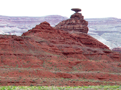
Halgaito Member of the Cutler Formation is responsible for the red landscape around Mexican Hat in southern Utah.
Permian, Early*
Wolfcampian*
Paradox basin*
San Juan basin*
San Juan Mountains province*
Black Mesa basin*
Uinta basin*
Piceance basin*
AZ*
CO(sw)*
NM(nw)*
UT(se)*
Not designated. Named for Cutler Creek, which enters Uncompahgre River about 4 mi north of Ouray, Ouray Co., CO (Cross and Howe, 1905).
Group rank (alphabetical): Cedar Mesa Formation (AZ,UT) or Cedar Mesa Sandstone (UT), De Chelly Sandstone (AZ*,CO*,NM*,UT), Elephant Canyon Formation (UT), Halgaito Formation (AZ*,CO*,NM*,UT*), Organ Rock Formation (AZ*,CO*,NM*,UT*), White Rim Sandstone (UT).
Formation rank (alphabetical): Cedar Mesa Sandstone Member (AZ*,CO*,NM*,UT*),
De Chelly Sandstone Member (AZ*,CO,NM*,UT*), Halgaito Member (AZ*,CO*,UT*)
or Halgaito Tongue (AZ*,UT*), Organ Rock Member (AZ*,UT*) or Organ Rock
Shale Tongue (NM) or Organ Rock Tongue (AZ*,UT*), White Rim Sandstone
Member (UT*).
Named (Cross and Howe, 1905). Revised, divided into Halgaito Tongue (base), Cedar Mesa Sandstone Member, Organ Rock Tongue, White Rim Sandstone Member (Baker and Reeside, 1929). Areal limits (Wood and Northrop, 1946). Revised, raised to group rank (Wengerd and Matheny, 1958). Revised (Shoemaker and Newman, 1959; Stewart, 1959). Overview (Baars, 1962). Mapped 1:24k in southeast Ouray Co, CO (Luedke, 1972). Revised, "lower Cutler beds" applied to rocks formerly assigned to upper Elephant Canyon Formation (Loope and others, 1990). Overview (Condon, 1992). Note that "Cutler" is not used by the USGS, but the name is recognized by the Utah Geological Survey and is widely cited in literature about the Canyonlands National Park region (see Baars, 2000).
References
Cross, C.W. and Howe, Ernest, 1905, Geography and general geology of the quadrangle, IN Description of the Silverton quadrangle [Colorado]: U.S. Geological Survey Geologic Atlas of the United States, Silverton folio, no. 120, 34 p.
Baker, A.A. and Reeside, J.B., Jr., 1929, Correlation of the Permian of southern Utah, northern Arizona, northwestern New Mexico, and southwestern Colorado: American Association of Petroleum Geologists Bulletin, v. 13, no. 11, p. 1413-1448.
Wood, G.H. and Northrop, S.A., 1946, Geology of Nacimiento Mountains, San Pedro Mountain, and adjacent plateaus in parts of Sandoval and Rio Arriba Counties, New Mexico: U.S. Geological Survey Oil and Gas Investigations Map, OM-57, 1 sheet, scale 1:95,040.
Wengerd, S.A. and Matheny, M.L., 1958, Pennsylvanian system of the Four Corners region: American Association of Petroleum Geologists Bulletin, v. 42, no. 9, p. 2048-2106.
Shoemaker, E.M. and Newman, W.L., 1959, Moenkopi formation (Triassic? and Triassic) in Salt anticline region, Colorado and Utah: American Association of Petroleum Geologists Bulletin, v. 43, no. 8, p. 1835-1851.
Stewart, J.H., 1959, Stratigraphic relations of Hoskinnini member (Triassic?) of Moenkopi formation on Colorado Plateau: American Association of Petroleum Geologists Bulletin, v. 43, no. 8, p. 1852-1868.
Baars, D.L., 1962, Permian system of Colorado Plateau: American Association of Petroleum Geologists Bulletin, v. 46, no. 2, p. 149-218.
Luedke, R.G., 1972, Geologic map of the Wetterhorn Peak quadrangle, Colorado: U.S. Geological Survey Geologic Quadrangle Map, GQ-1011, 1 sheet, scale 1:24,000.
Loope, D.B., Sanderson, G.A. and Verville, G.J., 1990, Abandonment of the name "Elephant Canyon Formation" in southeastern Utah; physical and temporal implications: The Mountain Geologist, v. 27, no. 4, p. 119-130.
Condon, S.M., 1992, Geologic framework of pre-Cretaceous rocks in the
Southern Ute Indian Reservation and adjacent areas, southwestern Colorado
and northwestern New Mexico, IN Geology and mineral resources of the Southern
Ute Indian Reservation: U.S. Geological Survey Professional Paper, 1505-A,
p. A1-A56.
Baars, D.L., 2000, Geology of Canyonlands National Park: In Geology of Utah's Parks and Monuments, Sprinkel, D.A., Chidsey,
T.C., and Anderson, P.B., editors, Utah Geological Association Publication
28., p. 61-83.