Coconino Sandstone
Coconino Sandstone (AZ*,CA*,NV*,UT*)
Coconino Quartzite (CA*)
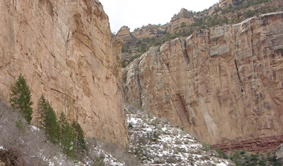
Cliffs of Coconino Sandstone along the Bright Angel Trail on Grand Canyon's South Rim.
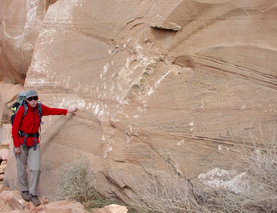
Crossbedding in the Coconino Sandstone along the Kaibab Trail of Grand Canyon's South Rim.
Permian, Early*
Early Middle Permian - 275 million years
(age used by National Park Service;
Mathis and Bowman, 2005)
Great Basin province*
Plateau sedimentary province*
Salton basin*
Basin and Range province*
Black Mesa basin*
AZ(n)*
CA(se)*
NV(e)*
UT(s)*
Not designated. Probably named for Coconino Plateau, Coconino Co., AZ (Darton, 1910).
(alphabetical): Cave Spring Member (AZ), Harding Point Member (AZ).
Named as middle formation of Aubrey Group (Darton, 1910). Age modified (Noble, 1923). Areal limits; Overview (Gilluly and Reeside, 1928). Revised (McKee, 1938; Winters, 1963). Redescribed; Revised; Overview (Hamilton, 1982). Revised, Harding Point and Cave Point Sandstone Members named; Areal limits (Blakey, 1990). Reference (Sorauf and Billingsley, 1991).
Coconino Sandstone (Lower Permian)—Tan to white, cliff-forming, fine-grained, wellsorted, cross-bedded quartz sandstone. Contains large-scale, high-angle, planar cross-bedded sandstone sets that average about 35 ft (11 m) thick. Locally includes poorly preserved fossil tracks and low-relief wind ripple marks on crossbedded planar sandstone surfaces. Lower 5–20 ft (2–6 m) is intertongued, thinbedded, partly calcareous, flat-bedded sandstone of Seligman Member of Toroweap Formation. Unconformable contact with underlying Hermit Formation is sharp planar, with relief generally less than 3 ft (1 m) but locally as much as 8 ft (2.5 m). Desiccation cracks in the Hermit, as much as 2 ft (0.05 m) wide and 12 ft (4 m) deep, are filled with tan sandstone of the Toroweap or Coconino, mainly in eastern third of map area. Thickness of the Coconino decreases east to west, whereas Brady Canyon and Seligman Members of Toroweap Formation increase proportionally in thickness. Forms a 500-ft (154-
m) thick cliff in southeast corner of map area, thinning northward to about 350 ft (122 m) and westward to about 150 ft (45 m) at western edge of map area.
References
Darton, N.H., 1910, A reconnaissance of parts of northwestern New Mexico and northern Arizona: U.S. Geological Survey Bulletin, 435, 88 p., (incl. geologic map, scale 1:1,000,000).
Noble, L.F., 1923, A section of the Paleozoic formations of the Grand Canyon at the Bass Trail, IN Shorter contributions to general geology, 1922: U.S. Geological Survey Professional Paper, 131-B, p. B23-B73.
Gilluly, James and Reeside, J.B., Jr., 1928, Sedimentary rocks of the San Rafael Swell and some adjacent areas in eastern Utah, IN Shorter contributions to general geology, 1927: U.S. Geological Survey Professional Paper, 150-D, p. D61-D110.
McKee, E.D., 1938, The environment and history of the Toroweap and Kaibab formations of northern Arizona and southern Utah: Carnegie Institution of Washington Publication, no. 492.
Winters, S.S., 1963, Supai Formation (Permian) of eastern Arizona: Geological Society of America Memoir, 89, 99 p.
Hamilton, Warren, 1982, Structural evolution of the Big Maria Mountains, northeastern Riverside County, southeastern California, IN Frost, E.G., and Martin, D.L., editors, Mesozoic-Cenozoic tectonic evolution of the Colorado River region, California, Arizona, and Nevada; Anderson-Hamilton volume: San Diego, CA, Cordilleran Publishers, p. 1-27, Published in conjunction with the Geological Society of America symposium and field trip, April, 1982.
Blakey, R.C., 1990, Stratigraphy and geologic history of Pennsylvanian and Permian rocks, Mogollon Rim region, central Arizona and vicinity: Geological Society of America Bulletin, v. 102, no. 9, p. 1189-1217.
Middleton, L.T., Elliot, D.K., Morales, M., 1990, Coconino Sandstone. In: Beus, S.S., Morales, M., editors, Grand Canyon Geology, Oxford University Press, New York, p. 183-202.
Sorauf, J.E. and Billingsley, G.H., 1991, Members of the Toroweap and Kaibab Formations, Lower Permian, northern Arizona and southwestern Utah: The Mountain Geologist, v. 28, no. 1, p. 9-24.
Rice, Jonathan Aaron, and Loope, David B., 1991, Wind-reworked carbonates, Permo-Pennsylvanian of Arizona and Nevada: Geological Society of America Bulletin, v. 103, no. 2, p. 254-267.
Hunt, Adrian P; Santucci, Vincent L., 2001, An unusual tetrapod track morphology from the Permian Coconino Sandstone, Grand Canyon National Park, Arizona: In, Proceedings of the 6th fossil resource conference; 2001 a fossil odyssey: Santucci, Vincent L., and McClelland, Lindsay, editors, U.S. National Park Service, Geological Resource Division, Technical Report: NRS/NRGRD/GRDTR-01/01, p. 44-47.
Peters, Richard A; Brand, Leonard R, 1991, Origin of polygonal compaction cracks in Permian Coconino Sandstone, Arizona: Geological Society of America, Abstracts with Programs, v. 31, no. 7, p. 160.
Whitmore, John H; Peters, Richard A., 1991, Reconnaissance study of the contact between the Hermit Formation and the Coconino Sandstone, Grand Canyon, Arizona: Geological Society of America, Abstracts with Programs, v. 7, no. 7, p. 235.
Billingsley, G. H., and Wellmeyer, J. L., 2001, Geologic map of the Cane Quadrangle, Coconino County, northern Arizona: U.S. Geological Survey Miscellaneous Field Studies Map MF-2366, 14 p, 1 sheet: Located on-line at: http://geopubs.wr.usgs.gov/map-mf/mf2366/
Billingsley, G. H., and Hampton, H. M., 2001, Geologic map of the House Rock Spring Quadrangle, Coconino County, northern Arizona: U.S. Geological Survey, Miscellaneous Field Studies Map MF-2367, 17 p, 1 sheet: Located on-line at: http://geopubs.wr.usgs.gov/map-mf/mf2367/.
Billingsley, George H., 2000, Geologic Map of the Grand Canyon 30' by 60' Quadrangle, Coconino and Mohave Counties, Northwestern Arizona: U.S. Geological Survey Geologic Investigation Series I-2688, Available on-line at: http://pubs.usgs.gov/imap/i-2688/.).
Mathis, A. and Bowman, C., 2005, What's in a number? Numeric ages for rocks exposed within the Grand Canyon, Part 2: Nature Notes ( Grand Canyon National Park ), v. 21, no. 2, p. 1-5.