Claron Formation
Claron Formation (NV,UT*)
Claron Limestone (UT)
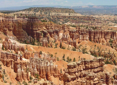
Erosion of the Claron Formation is responsible for the scenic landscape in Bryce Canyon National Park.
Tertiary*
Paleocene(?)*
Eocene*
Oligocene*
Great Basin province*
Wasatch uplift
UT(sw)*
NV
Type Locality:
Not designated (Leith and Harder, 1908).
Unit Name History:
First used (Leith and Harder, 1908). Revised (Mackin, 1947). Age modified
from Eocene to Eocene(?) (Mackin, 1954). Revised; Overview (Cook, 1957).
Revised (Mackin, 1960). Not used (Bowers, 1972). Age modified to Eocene
and Oligocene (though may be as old as latest Cretaceous); Overview (Anderson
and Rowley, 1975). Revised (Anderson, 1993). Age modified to Paleocene(?)
and Eocene in lower part; Mapped 1:24k in Paragonah quad, Iron Co, UT
(Maldonado and Williams, 1993). Age modified to Paleocene to late Eocene(?);
Revised, lower part designated as informal "Grand Castle formation"
(Goldstrand, 1994). Overview (Hintze and others, 1994; Rowley and others,
1994). Overview, locally is interbedded with lower part of overlying Oligocene
Wah Wah Springs Formation (McKee and others, 1997). Revised (Goldstrand
and Mullett, 1997.
References
Leith, C.K. and Harder, E.C., 1908, The iron ores of the Iron Springs district, southern Utah: U.S. Geological Survey Bulletin, 338, 102 p.
Mackin, J.H., 1947, Some structural features of the intrusions n the Iron Springs district [Utah]: Utah Geological Society, Guidebook to the geology of Utah, no. 2, 62 p.
Mackin, J.H., 1954, Geology and iron ore deposits of the Granite Mountain area, Iron County, Utah: U.S. Geological Survey Miscellaneous Field Studies Map, MF-l4, 1 sheet, scale 1:12,000.
Cook, E.F., 1957, Geology of the Pine Valley Mountains, Utah: Utah Geological and Mineral Survey Bulletin, no. 58, 111 p.
Mackin, J.H., 1960, Structural significance of Tertiary volcanic rocks in southwestern Utah: American Journal of Science, v. 258, no. 2, p. 81-131.
Bowers, W.E., 1972, The Canaan Peak, Pine Hollow, and Wasatch Formations in the Table Cliff region, Garfield County, Utah, IN Contributions to general geology: U.S. Geological Survey Bulletin, 1331-B, p. B1-B39.
Anderson, J.J. and Rowley, P.D., 1975, Cenozoic stratigraphy of southwestern high plateaus of Utah, IN Cenozoic geology of southwestern high plateaus of Utah: Geological Society of America Special Paper, 160, p. 1-51.
Maldonado, Florian and Williams, V.S., 1993, Geologic map of the Paragonah quadrangle, Iron County, Utah: U.S. Geological Survey Geologic Quadrangle Map, GQ-1713, 1 sheet, scale 1:24,000.
Anderson, J.J., 1993, The Markagunt megabreccia; large Miocene gravity slides mantling the northern Markagunt Plateau, southwestern Utah: Utah Geological Survey Miscellaneous Publication, no. 93-2.
Goldstrand, P.M., 1994, Tectonic development of Upper Cretaceous to Eocene strata of southwestern Utah: Geological Society of America Bulletin, v. 106, no. 1, p. 145-154.
Hintze, L.F., Anderson, R.E. and Embree, G.F., 1994, Geologic map of the Motoqua and Gunlock quadrangles, Washington County, Utah: U.S. Geological Survey Miscellaneous Investigations Series Map, I-2427, 7 p., 1 sheet, scale 1:24,000.
Rowley, P.D., Mehnert, H.H., Naeser, C.W., Snee, L.W., Cunningham, C.G., Steven, T.A., Anderson, J.J., Sable, E.G. and Anderson, R.E., 1994, Isotopic ages and stratigraphy of Cenozoic rocks of the Marysvale volcanic field and adjacent areas, west-central Utah: U.S. Geological Survey Bulletin, 2071, 35 p.
Goldstrand, P.M. and Mullett, D.J., 1997, The Paleocene Grand Castle Formation; a new formation on the Markagunt Plateau of southwestern Utah, IN Maldonado, Florian, and Nealey, D.L., editors, Geologic studies in the Basin and Range-Colorado Plateau transition in southeastern Nevada, southwestern Utah, and northwestern Arizona, 1995: U.S. Geological Survey Bulletin, 2153, p. 59-77.
McKee, E.H., Blank, H.R. and Rowley, P.D., 1997, K-Ar ages of Tertiary igneous rocks in the eastern Bull Valley Mountains and Pine Valley Mountains, southwestern Utah, IN Maldonado, Florian, and Nealey, L.D., editors, Geologic studies in the Basin and Range-Colorado Plateau transition in southeastern Nevada, southwestern Utah, and northwestern Arizona, 1995: U.S. Geological Survey Bulletin, 2153, p. 241-252.
Sable, E.G. and Kurlich, R.A., III, [no date available], Limerock Canyon Formation, IN Geologic map of the Hatch quadrangle, Garfield County, Utah: Utah Geological Survey Geologic Map Series.
Moore, David W., and Straub, Arthur W., 2001, Correlation of Upper Cretaceous and Paleogene(?) rocks beneath the Claron Formation, Crow Creek, western Markagunt Plateau, Southwest Utah: In, The geologic transition, high plateaus to Great Basin; a symposium and field guide; the Mackin volume, Erskine, M. C., Faulds, James E., Bartley, John M., and Rowley, Peter D. (editors), Pacific Section, American Association of Petroleum Geologists Guidebook, v. 78, p. 75-95.
Ott, Amy Lyn, 1999, Detailed stratigraphy and stable isotope analysis of the Claron Formation, Bryce Canyon National Park, southwestern Utah Washington State University masters thesis, 130 p.
Brown, Thomas M., Hasiotis, Stephen T., Genise, Jorge F., Maldonado, Florian, and Brouwers, Elisabeth M., 1997, Trace fossils of Hymenoptera and other insects, and paleoenvironments of the Claron Formation (Paleocene and Eocene), southwestern Utah: In, Geologic studies in the Basin and Range-Colorado Plateau transition in southeastern Nevada, southwestern Utah, and northwestern Arizona, Maldonado, Florian and Nealey, L. David (editors), U.S. Geological Survey Bulletin B 2153, p.41-58.
Davis, George H., and Pollock, Gayle L., 2000, Geology of Bryce Canyon National Park, Grand County, Utah: In Geology of Utah's Parks and Monuments, Sprinkel, D.A., Chidsey, T.C., and Anderson, P.B., editors, Utah Geological Association Publication 28., p. 37-60.