Chinle Formation
Chinle Formation of Dockum Group (CO*,NM*,TX)
Chinle Formation (AZ*,NM,NV*,UT*)
Chinle Group (NM,TX)
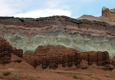
Chinle Formation (mostly shale) rises above brown cliffs of Moenkopi Formation in Capitol Reef National Park.
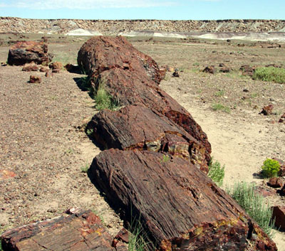
Petrified logs in the Chinle Formation in Petrified Forest National Park.
Triassic, Late*
Black Mesa basin*
Great Basin province*
Green River basin*
Las Vegas-Raton basin*
Orogrande basin
Palo Duro basin*
Paradox basin*
Permian basin
Piceance basin*
Plateau sedimentary province*
San Juan basin*
Sierra Grande uplift*
Uinta basin*
Uinta uplift*
Wasatch uplift*
AZ(n)*
CO(w)*
NV*
NM*
TX
UT*
Not designated. Named for Chinle Valley, Apache Co., AZ (Gregory, 1917).
Group rank (alphabetical): San Pedro Arroyo Formation (NM), Santa Rosa Formation (NM), Shinarump Formation (NM).
Unit Name History:
First used, intent to name not stated (Gregory, 1915). Adopted (Gregory,
1916). Named (Gregory, 1917). Revised, members assigned (Dobrovolny and
Summerson, 1946; Wood and Northrop, 1946). Revised (Bachman, 1953). Revised,
members assigned (Robeck, 1956; Stewart, 1957). Revised (Harshbarger and
others, 1957; Akers and others, 1958; Cooley, 1958; Shoemaker and Newman,
1959; Griggs and Read, 1959). Overview (Poole and Stewart, 1964). Revised,
members assigned (Sikich, 1965). Areal limits (Wilson and Stewart, 1967).
Revised (Cooley and others, 1969). Areal limits; Overview (Stewart and
others, 1972a). Revised (Stewart and others, 1972b). Revised, members
assigned (Kelley, 1972). Revised (Green, 1974; Blakey, 1974). Areal limits;
Overview (Barnes, 1976). Mapped 1:24k in southwest Moffat Co., CO (Rowley
and Hansen, 1979). Areal limits; Overview (Barnes, 1983). Not used (Chatterjee,
1986). Overview (Dubiel, 1987). Revised (Lucas and Hunt, 1987). Not used
(Lucas and Hunt, 1989). Revised, members assigned (Lucas and Hayden, 1989).
Rock Point Member assigned (Dubiel, 1989). Chinle Group divided into Shinarump
or Santa Rosa Formation, and San Pedro Arroyo Formation (Lucas, 1991).
Overview (Dubiel and others, 1992; Hintze and Axen, 1995).
References
Gregory, H.E., 1915, The igneous origin of the "glacial deposits" of the Navajo Reservation, Arizona and Utah: American Journal of Science, 4th series, v. 40, art. 8, p. 97-115.
Gregory, H.E., 1916, The Navajo country: U.S. Geological Survey Water-Supply Paper, 380, 219 p.
Gregory, H.E. and Stone, R.W., 1917, Geology of the Navajo country; a reconnaissance of parts of Arizona, New Mexico, and Utah: U.S. Geological Survey Professional Paper, 93, 161 p.
Wood, G.H. and Northrop, S.A., 1946, Geology of Nacimiento Mountains, San Pedro Mountain, and adjacent plateaus in parts of Sandoval and Rio Arriba Counties, New Mexico: U.S. Geological Survey Oil and Gas Investigations Map, OM-57, 1 sheet, scale 1:95,040.
Dobrovolny, Ernest and Summerson, C.H., 1946, Geology of northwestern Quay County, New Mexico: U.S. Geological Survey Oil and Gas Investigations Map, OM-62, 1 sheet, scale approx. 1 in. = 1 mi.
Bachman, G.O., 1953, Geology of a part of northwestern Mora County, New Mexico: U.S. Geological Survey Oil and Gas Investigations Map, OM-137, 1 sheet, scale 1:48,000.
Robeck, R.C., 1956, Temple Mountain member; new member of Chinle formation in San Rafael Swell, Utah: American Association of Petroleum Geologists Bulletin, v. 40, no. 10, p. 2499-2506.
Stewart, J.H., 1957, Proposed nomenclature of part of the Upper Triassic strata of southeastern Utah: American Association of Petroleum Geologists Bulletin, v. 41, no. 3, p. 441-465.
Harshbarger, J.W., Repenning, C.A. and Irwin, J.H., 1957, Stratigraphy of the uppermost Triassic and the Jurassic rocks of the Navajo country: U.S. Geological Survey Professional Paper, 291, 74 p.
Akers, J.P., Cooley, M.E. and Repenning, C.A., 1958, Moenkopi and Chinle formations of Black Mesa and adjacent areas, IN Anderson, R.Y., and Harshbarger, J.W., editors, Guidebook of the Black Mesa basin [northeastern Arizona]: New Mexico Geological Society Guidebook, no. 9, p. 88-94.
Cooley, M.E., 1958, The Mesa Redondo member of the Chinle formation, Apache and Navajo Counties, Arizona: Plateau, v. 31, no. 1, p. 7-15.
Shoemaker, E.M. and Newman, W.L., 1959, Moenkopi formation (Triassic? and Triassic) in Salt anticline region, Colorado and Utah: American Association of Petroleum Geologists Bulletin, v. 43, no. 8, p. 1835-1851.
Griggs, R.L. and Read, C.B., 1959, Revisions in stratigraphic nomenclature in Tucumcari-Sabinoso area, northeastern New Mexico: American Association of Petroleum Geologists Bulletin, v. 43, no. 8, p. 2003-2007.
Poole, F.G. and Stewart, J.H., 1964, Chinle Formation and Glen Canyon Sandstone in northeastern Utah and northwestern Colorado, IN Geological Survey research 1964: U.S. Geological Survey Professional Paper, 501-D, p. D30-D39, Also, 1964, Intermountain Association of Petroleum Geologists, 13th Annual Field Conference, Guidebook to the geology and mineral resources of the Uinta basin, Utah's hydrocarbon storehouse, p. 93-104.
Sikich, S.W., 1965, Upper Triassic stratigraphy in the eastern Uinta Mountains: The Mountain Geologist, v. 2, no. 3, p. 167-172.
Wilson, R.F. and Stewart, J.H., 1967, Correlation of Upper Triassic and Triassic(?) formations between southwestern Utah and southern Nevada, IN Contributions to stratigraphy, 1966: U.S. Geological Survey Bulletin, 1244-D, p. D1-D20.
Cooley, M.E., Harshbarger, J.W., Akers, J.P. and Hardt, W.F., 1969, Regional hydrogeology of the Navajo and Hopi Indian Reservations, Arizona, New Mexico, and Utah, IN Hydrogeology of the Navajo and Hopi Indian Reservations, Arizona, New Mexico and Utah: U.S. Geological Survey Professional Paper, 521-A, p. A1-A61, (incl. geologic map, scale 1:125,000), Prepared in cooperation with the Bureau of Indian Affairs and the Navajo Tribe.
Stewart, J.H., Poole, F.G. and Wilson, R.F., 1972, Stratigraphy and origin of the Chinle Formation and related Upper Triassic strata in the Colorado Plateau region: U.S. Geological Survey Professional Paper, 690, 336 p.
Kelley, V.C., 1972, Geology of the Fort Sumner sheet, New Mexico: New Mexico Bureau of Mines and Mineral Resources Bulletin, no. 98, 55 p.
Stewart, J.H., Poole, F.G. and Wilson, R.F., 1972, Stratigraphy and origin of the Triassic Moenkopi Formation and related strata in the Colorado Plateau region: U.S. Geological Survey Professional Paper, 691, 336 p.
Green, M.W., 1974, The Iyanbito Member (a new stratigraphic unit) of the Jurassic Entrada Sandstone, Gallup-Grants area, New Mexico, IN Contributions to stratigraphy: U.S. Geological Survey Bulletin, 1395-D, p. D1-D12.
Blakey, R.C., 1974, Stratigraphic and depositional analysis of the Moenkopi Formation, southeastern Utah: Utah Geological and Mineral Survey Bulletin, no. 104, 81 p.
Barnes, V.E., 1976, Geologic atlas of Texas, Hobbs Sheet; William Battle Phillips memorial edition: University of Texas-Austin, Bureau of Economic Geology, 1 sheet, scale 1:250,000.
Rowley, P.D. and Hansen, W.R., 1979, Geologic map of the Plug Hat quadrangle, Moffat County, Colorado: U.S. Geological Survey Geologic Quadrangle Map, GQ-1514, 1 sheet, scale 1:24,000.
Barnes, V.E., 1983, Geologic atlas of Texas, Tucumcari Sheet; Henryk Bronislaw Stenzel memorial edition: University of Texas-Austin, Bureau of Economic Geology, 1 sheet, scale 1:250,000.
Chatterjee, Sankar, 1986, The Late Triassic Dockum vertebrates; their stratigraphic and paleobiogeographic significance, Chapter 10, IN Padian, Kevin, ed., The beginning of the age of dinosaurs; faunal change across the Triassic-Jurassic boundary: Cambridge, UK, Cambridge University Press, p. 139-150.
Dubiel, R.F., 1987, Sedimentology and new fossil occurrences of the Upper Triassic Chinle Formation, southeastern Utah, IN Campbell, J.A., ed., Geology of Cataract Canyon and vicinity 1987; field symposium: Four Corners Geological Society Field Conference Guidebook, 10th Field Conference, Durango, CO, May 14-17, 1987, p. 99-107.
Lucas, S.G. and Hunt, A.P., 1987, Stratigraphy of the Anton Chico and Santa Rosa Formations, Triassic of east-central New Mexico: Arizona-Nevada Academy of Science Journal, v. 22, no. 1, p. 21-33.
Lucas, S.G. and Hunt, A.P., 1989, Revised Triassic stratigraphy in the Tucumcari basin, east-central New Mexico, IN Lucas, S.G., and Hunt, A.P., editors, Dawn of the age of dinosaurs in the American southwest: New Mexico Museum of Natural History, p. 150-170.
Lucas, S.G. and Hayden, S.N., 1989, Triassic stratigraphy of west-central New Mexico, IN Anderson, O.J., and others, editors, Southeastern Colorado Plateau: New Mexico Geological Society Guidebook, no. 40, p. 191-211.
Dubiel, R.F., 1989, Sedimentology and revised nomenclature of the Upper Triassic Chinle Formation and the Lower Jurassic Wingate Sandstone, northwestern New Mexico and northeastern Arizona, IN Anderson, O.J., and others, editors, Southeastern Colorado Plateau: New Mexico Geological Society Guidebook, no. 40, p. 213-223.
Lucas, S.G., 1991, Triassic stratigraphy, paleontology and correlation, south-central New Mexico, IN Geology of the Sierra Blanca, Sacramento and Capitan Ranges, New Mexico: New Mexico Geological Society Guidebook, no. 42, p. 243-253.
Dubiel, R.F., Skipp, Gary and Hasiotis, S.T., 1992, Continental depositional environments and tropical paleosols in the Upper Triassic Chinle Formation, Eagle basin, western Colorado, IN Flores, R.M., ed., Field guidebook; Mesozoic of the Western Interior: Society of Economic Paleontologists and Mineralogists, Rocky Mountain Section, [Field Trip Guidebook], 1992 Theme Meeting, p. 21-37.
Hintze, L.F. and Axen, G.J., 1995, Geologic map of the Scarecrow Peak Quadrangle, Washington County, Utah and Lincoln Co, Nevada: U.S. Geological Survey Geologic Quadrangle Map, GQ-1759, 1 sheet, scale 1:24,000.
Rice, Jonathan A., and Loope, David B., 1991, Wind-reworked carbonates, Permo-Pennsylvanian of Arizona and Nevada: Geological Society of America Bulletin, v. 103, no. 2, p. 254-267.
Riggs, N. R., Ash, S. R., Barth, A. P., Gehrels, G. E., Wooden, J. L., 2003, Isotopic age of the Black Forest Bed, Petrified Forest Member, Chinle Formation, Arizona., an example of dating a continental sandstone:Geological Society of America Bulletin, v. 115, no. 11, p. 1315-1323.
Ash, Sidney, 2004, The Wolverine Petrified Forest: Utah Geological Survey, Survey Notes, v. 35, no. 3, p. 3-6.
Ziegler, Kate E., and Lucas, Spencer G., 2002, Taphonomy of the Late Triassic Lamy Amphibian Quarry (Garita Creek Formation, Chinle Group), central New Mexico: New Mexico Geology, v. 24, no. 2, p. 61.
Tanner, Lawrence H., 2000, Palustrine-lacustrine and alluvial facies of the (Norian) Owl Rock Formation (Chinle Group), Four Corners region, Southwestern U.S.A., implications for Late Triassic paleoclimate: Journal of Sedimentary Research, v. 70, no. 6, p. 1280-1289.
Therrien, Francois, and Fastovsky, David E., 2000, Paleoenvironments of early theropods, Chinle Formation (Late Triassic), Petrified Forest National Park, Arizona: Palaios, v. 15, no. 3, p. 194-211.
Steiner, Maureen B., Lucas, Spencer G., 2000, Paleomagnetism of the Late Triassic Petrified Forest Formation, Chinle Group, Western United States., further evidence of "large" rotation of the Colorado Plateau: Journal of Geophysical Research, B, Solid Earth and Planets, v. 105, no. 11, p. 25,791-25,808.
Parrish, J. Michael, 1999, Small fossil vertebrates from the Chinle Formation
(Upper
Triassic) of southern Utah: In, Vertebrate paleontology in Utah, Gillette,
David D., ed.,
Utah Geological Survey, Miscellaneous Publication, vol.99-1, p. 5-50.
Lucas, Spencer G., Heckert, Andrew B., Estep, J W., Anderson, Orin J., 1997, Stratigraphy, biostratigraphy, and sequence stratigraphy of the Upper Triassic Chinle Group, Four Corners region: New Mexico Geological Society, 48th annual field conference, (Cortez, NM, Oct. 1-4, 1997), v. 48, p. 81-107.
Lucas, Spencer G., 1997, Upper Triassic Chinle Group, Western United
States., a nonmarine
standard for Late Triassic time: In, Late Palaeozoic and early Mesozoic
Circum-Pacific events and their global correlation, Dickins, J. M., ed.,
World and Regional Geology, v. 10, p. 209-228.
Riggs, N. R., Lehman, T. M., Gehrels, G. E., Dickinson, W. R., 1996,
Detrital zircon link between headwaters and terminus of the Upper Triassic
Chinle-Dockum paleoriver system:
Science, v. 273, no. 5271, p. 97-100.
Riggs, N. R., Ash, S. R., Barth, A. P., Gehrels, G. E., and Wooden, J. L., 2003, Isotopic age of the Black Forest Bed, Petrified Forest Member, Chinle Formation, Arizona: An example of dating a continental sandstone: Geological Society of America Bulletin, v. 115, no. 11, p. 1315-1323.
Woody, D. T., Revised stratigraph of the lower Chinle Formation (Upper Triassic) of Petrified Forest National Park, Arizona: in A Century of Research at Petrified Forest National Park: Geology and Paleontology: Parker, W. G., Ash, S. R., and Irmis, R. B., editors, Flagstaff, Arizona: Museum of Northern Arizona Bulletin no. 62, p. 17-45.