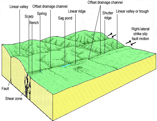
The Carrizo Plain is described as the "best place" to observe geomorphic features along the San Andreas fault. This graphic, modified from Vedder and Wallace, 1970, illustrates many of the features observable in the park. Note that a "shear zone" is a simply a complex fault (or fault zone). Landscape features associated with faulting and folding within or along the fault zone include elongage grabens or troughs (where sag ponds can form), linear scaplets and ridges, shutter ridges, medial ridges, fold ridges, en echelon lineaments, and tilted and rotated blocks. Many of the geomorphic features result from differential rates of uplift and/or depression, lateral motion, block tilting, and warping of the rocks and sediments adjacent to the faulting (Wallace, 1975). Erosion, deposition, and stream pattern changes over time add to the complexity of the evolving landscape. Beheaded stream are are offset streams where the upstream channel has found a new drainage route. A shutter ridge is a hill that blocks an offset stream (it may be a linear ridge).