
Regional Geology of North America |
Western Desert Provinces |
Click on images for a |
| Basin and Range is the term used to describe the general topography of a vast region of the Western Cordillera extending from southern Oregon to West Texas (Figure 183). The Basin and Range is subdivided into three physiographic Provinces. In the north is the Great Basin, a vast region of mountain ranges and low desert valleys that has no external drainage connection to the ocean. The Mojave Desert and Colorado Desert provinces encompasses parts of southern California and southern Nevada. In the southeast is the province name Basin and Range that extends from the Colorado River west across southern Arizona, New Mexico, into West Texas. The Basin and Range is generally characterized by north-to-south trending mountain ranges with intervening valleys. Valley elevations range from below sea level to about 2,000 feet, mountain ranges average about 7,000 feet with several rising above 12,000 feet. The basin and range topography is a result of crustal extension associated with the plate-tectonic history of western North America (see Figure 105). Starting about 25 million years ago, the North America Plate gradually moved over a spreading center that separated the ancient Farallon Plate from the Pacific Plate. The spreading center is now underneath the Basin and Range Province, causing it to gradually spread apart (Figure 184). |
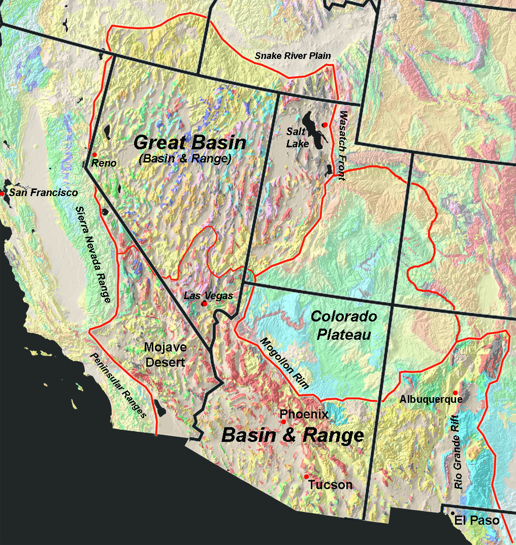 |
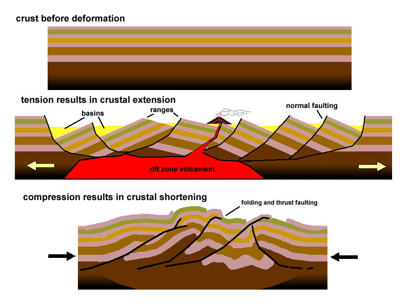 Fig. 184. Geologic structures associated with crustal compression and extension. Basin and Range provinces have experience crustal extension gradually over the past 18 million years. |
| Fig. 183. Map of the Basin and Range Provinces: Great Basin, Mojave, and Basin and Range sub provinces. |
| Since about 18 million years ago, the Basin and Range has slowly expanded as the Sierra Nevada Range has slowly moved north and west relative to the rest of the western North American craton (Rocky Mountains and Colorado Plateau regions). This caused the Basin and Range region to stretch apart (crustal extension). What started as continental rifting translated into the splitting of the crust into a series of large, parallel, crustal blocks that gradually rotated, creating a horst-and-graben structure—much like books sliding against each other as they fall over on a shelf. Estimates are the Basin and Range has expanded by as much as 300 miles. The eastern and western margins of the Great Basin are generally where most tectonically is actively occurring, but great earthquakes have happened all across the region. Volcanism has also generally followed the rifting along the margins of the basin, especially where it gradually expands eastward. The Basin and Range provinces encompasses four desert regions of North America including the Great Basin, Mojave, Sonoran, and Chihuahuan deserts (Figure 185). The highest ranges typically have pine forests, and mixed evergreen and deciduous forests. In contrast, during the peak of the Pleistocene ice ages, the region was wetter, and great lakes filled many of the low, internally drained basins across the region (Figure 186). |
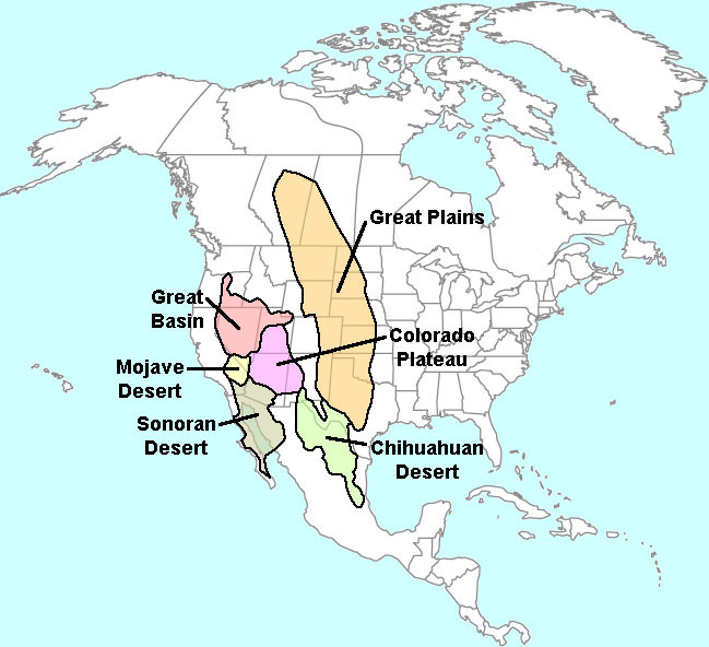 Fig. 185. Deserts and steppe regions of North America. |
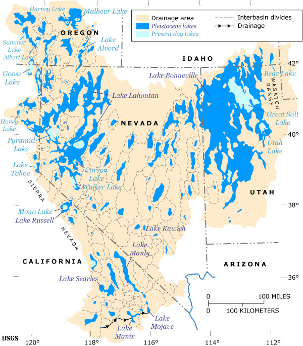 Fig. 186. Pleistocene Lakes in the Great Basin and Mojave. |
| https://gotbooks.miracosta.edu/geology/regions/basin_and_range_provinces.html 1/20/2017 |