Regional Geology of North America |
|
Valley and Ridge Province |
Click on images for a
larger view. |
The Valley and Ridge Province is a subdivision of the greater Appalachian Mountains. It is a broad, mountainous region east of the Blue Ridge Mountains and extends from upstate New York to Alabama, and is bounded on the west by the Appalachian Plateaus Province. Parallel to the western side of the Blue Ridge is the Great Appalachian Valley. The western side of the Valley and Ridge Province, the Allegheny Front (an escarpment) marks the western boundary with the Appalachian Plateaus Province.
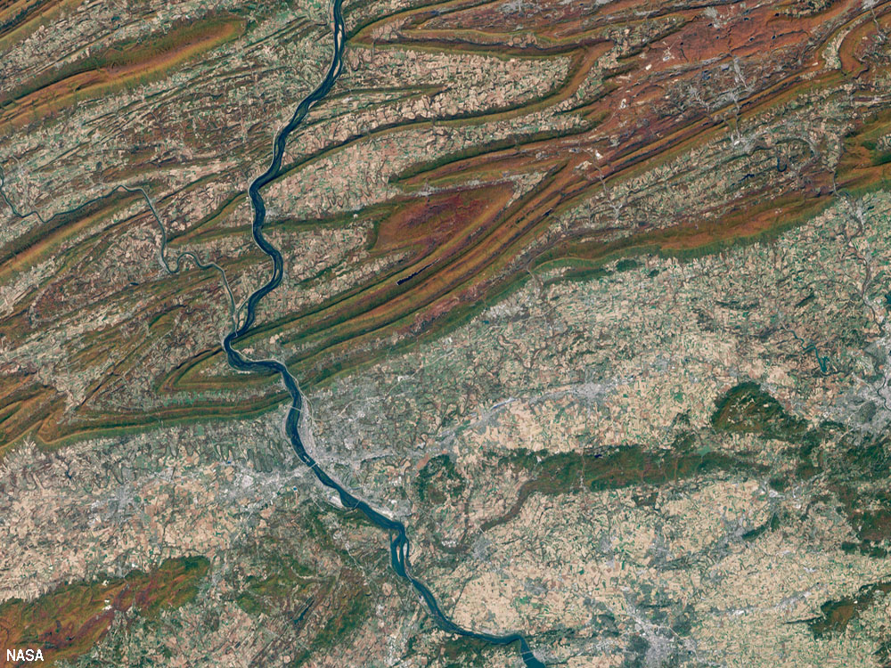
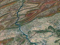
The Valley-and-Ridge Province is characterized as a series of ridge lines and intervening valleys that reflect the erosional characteristics of rock layers that have been folded and thrust faulted into complex structures, mostly anticlines and synclines, very similar to folds in a carpet that has been pushed up against a wall (Figure 33). Sedimentary rocks exposed throughout the Valley and Ridge are part of the Appalachian Basin, a thick sequence of sedimentary deposits that represented the continental margin basin deposits before continents assembled to form supercontinent Pangaea.
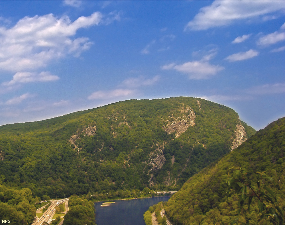
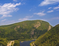
During the Allegheny Orogeny in Late Paleozoic time, the North American Plate was colliding with the African Plate. The upper layers of the crust, composed mostly of layers of sedimentary rock, was shoved westward, creating a series of northeast-southwest-trending structural folds. Erosion over the last 200 million years have stripped away thousands of feet of overlying sediments, exposing the folds and complex structure we see today. Unlike rocks of the Piedmont and Blue Ridge, rocks of the Valley and Ridge Province have experiences minimal metamorphism. However, harder, erosion-resistant rock layers from ridges and softer layers erode to form valleys. In many cases, the axis of anticlines are now valleys and axis of synclines are now ridges (Figures 33-36). The ancient age of the landscape is reflected by the unusual river systems that cut across the ridge lines. The Delaware, Susquehanna, New, and Potomac Rivers all drain eastward and cut through the Valley and Ridge region. These rivers probably flowed eastward across unconsolidated sediments that covered the region in the geologic past when there was little topographic relief and before the region was later uplifted to its current elevations. The result is that the rivers cut through “water gaps” that are perpendicular to the hard strata that form the ridges (Figure 35).
Historically, the parallel series of ridges and valleys created problems for the growing nation of the United State to expand westward. Land travel westward in the age of walking or riding horses was hindered by the seemly endless number of ridges in the region. Even today, the region is sparsely populated compared to the lowland regions east and west of the Appalachians. Cumberland Gap is the only low pass in the Cumberland Mountains, a long up-thrusted ridge over a hundred miles long located of along the western margin of the Valley and Ridge Province along the border of Kentucky, Tennessee, and West Virginia. In the late 1780s and 90s, a crew lead by explorer Daniel Boone constructed the Wilderness Road through Cumberland Gap as the first overland wagon road for settlers moving westward across the Applachian Mountains into Kentucky and the Ohio River Valley region.
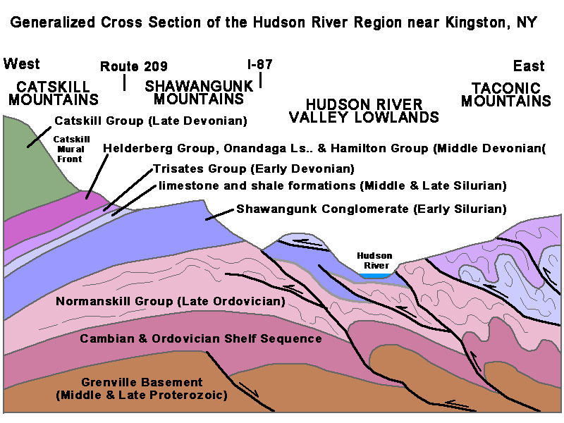
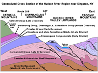
The Hudson River Valley in New York roughly defines the northern boundary between the Taconic Mountains (to the east) and Catskill Mountains (to the west)(Figure 36). The Taconic Mountains are folded and faulted similar to the Valley and Ridge, but are more ancient (and are included in the New England Province). The Catskills are the northern end of the Appalachian Plateaus Province. |
 |
 |
 |
 |
| Fig. 33. Satellite view of the Harrisburg, Pennsylvania region showing the folded layers of the Valley and Ridge Province (top) and Piedmont region (bottom). |
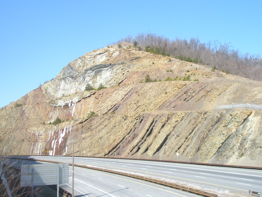
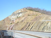
Fig. 34. An inverted geologic paradox: a syncline that is now a ridge line, is exposed along a cut in Sideling Hill along I-68 in western Maryland. |
Fig. 35. Delaware Water Gap NRA is where the Delaware River cuts through Kittatinny Mountain, in the northern Valley and Ridge Province in New Jersey and Pennsylvania. |
Fig. 36. Generalized cross section of the Hudson River Valley region with fold-thrust belt of the Taconic Mountains east of the Catskills Mountains in New York. |
|
| https://gotbooks.miracosta.edu/geology/regions/valley_and_ridge.html 1/20/2017 |

|
 |
|
|