
Regional Geology of North America |
|
High Plains and Plateaus of West Texas |
Click on images for a
larger view. |
The High Plains are a sub region of the Great Plains Province that roughly corresponds with the outcrop belt of the Ogallala Formation ranging from western South Dakota south to the Texas Panhandle (see Figure 72). The region ranges in elevation of about 1,200 feet to over 7,800 feet. The southern Great Plains is subdivided into many sub regions, each with their own characteristic features (Figure 73).
Llano Estacado
The city of Amarillo is located on the Llano Estacado is the southern portion of the High Plains in the region south of the Canadian River on the Texas Panhandle. The plains landscape around Amarillo, Texas (elevation 3,606′) is one of the flattest regions in North America (Figure 74). The eastern boundary of the Llano Estacado is the Caprock Escarpment, a prominent rim of cliffs and canyons carved in the headwater regions of tributaries the Red and Brazos Rivers in West Texas (Figure 75). Below a caprock of Ogallala Formation, red rock layers of Permian and Triassic age are exposed along the canyon and escarpment.
Palo Duro Canyon is Often called the “Grand Canyon of Texas” —it is the second largest canyon in the United States (Figure 76). The canyon is located on the Prairie Dog Town Fork of the Red River, about 30 miles south of Amarillo. The canyon about 70 miles long and between 6 and 20 miles wide, and 800-1,000 feet deep. The canyon is incised into the surface of the Llano Estacado and cuts through the Caprock Escarpment.
The Llano Estacado extends west to the Mescalero Escarpment that faces the eastern foothills of the Southern Rocky Mountains, Sandia Mountains, and Sacramento Mountains of New Mexico.
|
Edwards Plateau
The Llano Estacado gradually transitions into the Edwards Plateau to the south and east in central Texas (see Figure 73). The eastern end of the Edwards Plateau is called Texas Hill Country—a region characterized by forested high hills with bedrock of karst limestone and granite, and valleys with broad floodplains. Texas Hill Country is bound on the north by the Llano Uplift. The southeast side of the Edwards plateau is bordered by the Balcones Escarpment, a line of hills associated with the Balcones Fault Zone. The Texas cities of Austin and San Antonio are spread along the Balcones Escarpment. |
Ouachita Orogenic Features in Texas
The rise of the Rocky Mountains shed sediments that blanketed the entire region gradually, filling in valleys and burying older regional upland landscape features through most of Cenozoic time. Late Tertiary regional uplift and climate changes during the Pleistocene ice ages has allowed erosion to re-expose some of the older geologic structures in the region, including the Llano Uplift and the Marathon Mountains.
The Llano Uplift is located in central Texas region in the northern part of the Texas Hill Country and east of the Edwards Plateau region. It is a roughly circular dome of g exposed crystalline basement rocks of Precambrian-age. Bedrock at the center of the uplift consists granite, such as those exposed in Enchanted Rock State Park, Texas (Figure 77). The granite surrounded by a belt of metamorphic rocks (chiefly gneiss and schist) with an outer margin along the flanks that consist of limestone of Early Paleozoic age that locally forms low escarpments and ridges. The Llano Uplift is another geologic structure that formed concurrent with the Ouachita Orogeny, although it is not part of the thrust-faulted orogenic belt that is buried beneath the sedimentary cover further south.
The Marathon Mountains of West Texas are the western-most exposure of rocks associated with the Ouachita Orogenic belt. This mountainous area covers a region about 80 miles in diameter (Figure 78). Rocks exposed along the flanks of the uplift include folded sedimentary layers of Early Paleozoic (pre-Permian) age. The Paleozoic-age strata exposed includes novaculite that are exposed in northeast-trending ridges (consistent with general trend of the Ouachita Orogenic Belt; see Figure 73). An angular unconformity separates these folded layers from overlying flat-lying marine sedimentary rocks of Cretaceous age. Regional uplift and erosion during the Cenozoic Era have exposed the older rock formations on the flanks of the low mountain range. The mountains are a geologic dome-like feature that rise about 800 feet above lowlands in the surrounding region. |
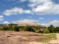 Fig. 77. Enchanted Rock, a large outcrop of granite exposed in the core of the Llano Uplift. Fig. 77. Enchanted Rock, a large outcrop of granite exposed in the core of the Llano Uplift. |
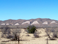
Fig. 78. Layers of novaculite and sandstone of Paleozoic age form a serrated hogback ridge along the flank of the Marathon Uplift. |
| https://gotbooks.miracosta.edu/geology/regions/texas_high_plains.html 1/20/2017 |

|
 |
Permian
Basin |
|
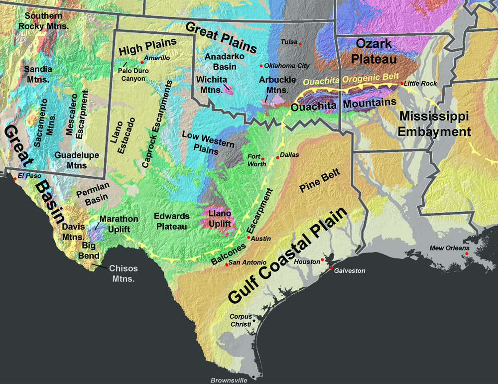

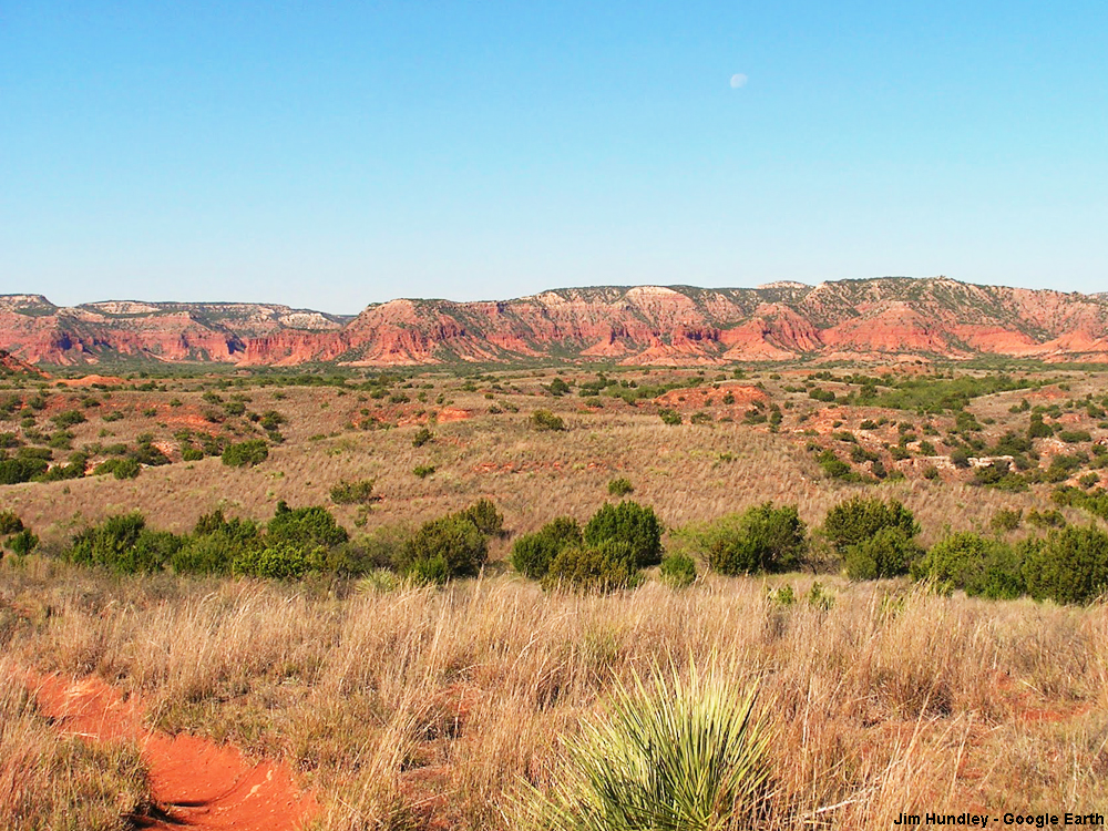
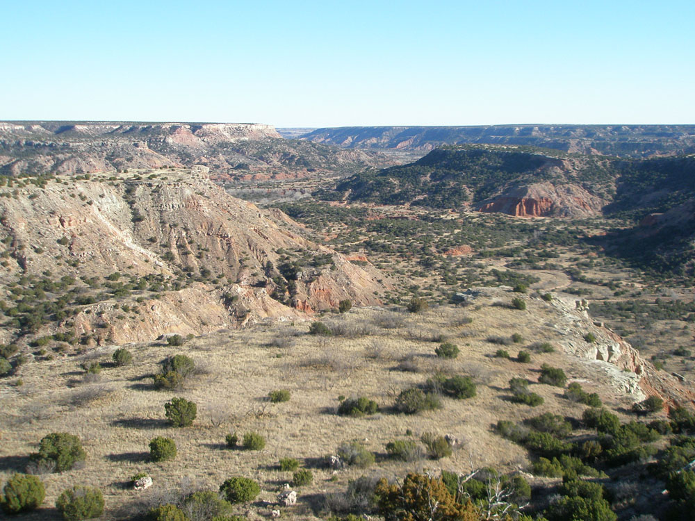
 Fig. 77. Enchanted Rock, a large outcrop of granite exposed in the core of the Llano Uplift.