
Introduction to Physical Geology |
Chapter 5 - Earth's Structure and Plate Tectonics |
| This chapter reviews the major concepts of the structure of the Earth and describes the dynamic processes associated the formation of distinct layers within the earth. This is essential information to understand the Theory of Plate Tectonics. The Theory of Plate Tectonics explains how the Earth’s surface is broken up into
large plates of crustal rock whose slow movements create earthquakes, volcanoes, and
mountains, changing the way the Earth looks over geologic time. While much has been discovered about the character and natural resources of our planet since the time of Christopher Columbus's first voyage, little was know about the internal character of the Earth until the Cold War era following World War II. Although studies of the internal structure of the earth were first reported in the late 19th century using seismic wave data from great earthquakes, it was the data from testing, spying, and verification of underground nuclear explosions that provided a clearer, more detailed picture of the internal structure of our planet. The Earth is composed of several zones, including a central core, a mantle, and a crust (Figure 5-2). All parts are held together and have their characteristics based on the force of gravity, their chemical composition, and largely how they formed and changed through geologic time. The solid earth has a central core (both solid & liquid), a mantle (mostly solid though capable of slow flow by heat convection), and the crust (solid). Oceans (hydrosphere), glaciers (cryosphere), and atmosphere rest on the surface of the crust. The appearance of the world as we see it today is a result of the accumulative effects of all geologic processes that have happened in the past. Some of these processes occur rapidly (such as volcanic eruptions, earthquakes, great storms and flood, and occasional asteroid impacts). However, most features we see on the landscape or in a region (or larger features like continents) involve processes that are far grander, operating both near and deep below the surface, and taking place gradually over long periods of time (in spans measured in millions to hundreds-of-millions of years). For instance, the coast lines of northwest Africa and the eastern United States are currently moving apart at a rate of about 2-4 inches a year. However, about 200 million years ago the two continents were joined together before the opening and formation of the Atlantic Ocean basin! Plate tectonics theory helps explain most of the processes and grand landscape features we observe around the world today, both on land and beneath the oceans. |
Click on small images for a larger view throughout this website. |
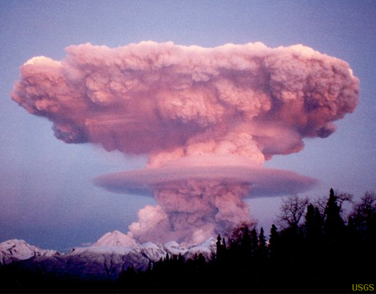 Fig. 5-1. Nearly all geologic processes observed on Earth fit in some way into Plate Tectonics Theory. 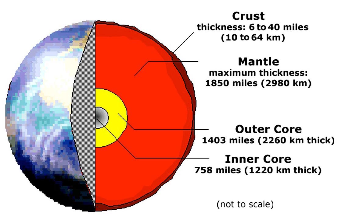 Fig. 5-2. Structure of the Earth: crust, mantle, and core. |
Subdivisions of the Structure of the Solid EarthThe Earth consist of several parts: a core, a mantle, and a crust (Figures 5-2 and 5-3). Other planets and moons in our Solar System share some of these characteristics:
|
 Fig. 5-3. Structure of the Earth showing more detail. Subdivisions on the left are based on composition, whereas the subdivisions on the right are based on physical properties. Note that the lithosphere encompasses both the crust and the upper part of the mantle. |
Layers of the Earth As Defined By Physical PropertiesWith increasing depth, Earth’s interior is characterized by gradual increases in temperature, pressure, and density.Depending on the temperature and depth, a particular Earth material may behave like a brittle solid, deform in a plastic–like manner, or melt and become liquid. Figure 5-3 illustrates the structure of the Earth highlighting the physical properties of the different layers. Lithosphere (means sphere of rock)The term lithosphere is used to describe the rigid outer part of the Earth, consisting of the crust and upper mantle. Compared with other layers of the Earth, the lithosphere is a relatively cool, rigid shell and averages about 60 miles (100 km) in thickness, but may be about 155 miles (250 km) or more thick beneath the older portions of the continents. The lithosphere is broken up into moving plates, and the movements of these plates are responsible for all the large-scale features observable on the surface—including ocean basins, continents, and mountain ranges. Because lithosphere is cooler than the underlying asthenosphere, it behaves in a more brittle manner. Based on seismic studies, the lithosphere is the region where all earthquakes take place.Asthenosphere (means weak sphere)The term asthenosphere refers to a semi-fluid layer beneath the lithosphere (within the upper mantle), between about 60 to 400 miles (100-650 km) below the outer rigid lithosphere (oceanic and continental crust) forming part of the upper mantle (see Figure 5-3). The asthenosphere, although solid, is very hot and the pressure is great enough for material to be able to slowly flow vertically and horizontally. This enables sections of lithosphere to undergo movements associated with plate tectonics. Geologist use the term plastic to describe how hot solid materials, including rocks, can deform and flow slowly. Since rocks in the asthenosphere are hot, they will deform rather than fracture under pressure. This movement is driven by the heat derived from the deeper parts of the mantle and core that allow materials to flow by gravitational heat convection). Gravitational heat convection results when hot materials expand and rise, and cold materials contract and sink (Figure 5-4).Mesosphere (or Lower Mantle)This region is a rigid layer between the depths of about 400 to 1800 miles (650 km and 2900 km), but the rocks at these depths are very hot and capable of gradual flow. Heat from the core drives lower mantle convection.Outer CoreGeophysical studies show that Earth's outer core is a liquid layer. Gravity and seismic studies suggest that the outer core is mostly of an mixture of metallic iron and nickel (similar in composition to metallic meteorites). Convective flow within this metallic outer core generates Earth’s magnetic field.Inner CoreGeophysical studies show that Earth's inner core behaves like a solid, but is very dense, around 16 grams/cm3 (probably composed of a iron-nickel alloy similar to the composition of iron-nickel meteorites; Figure 5-5). |
 Fig. 5-4. A classic lava lamp illustrates gravitational heat convection (similar to movement of hot and cooling materials rising and sinking in the mantle). Fig. 5-4. A classic lava lamp illustrates gravitational heat convection (similar to movement of hot and cooling materials rising and sinking in the mantle).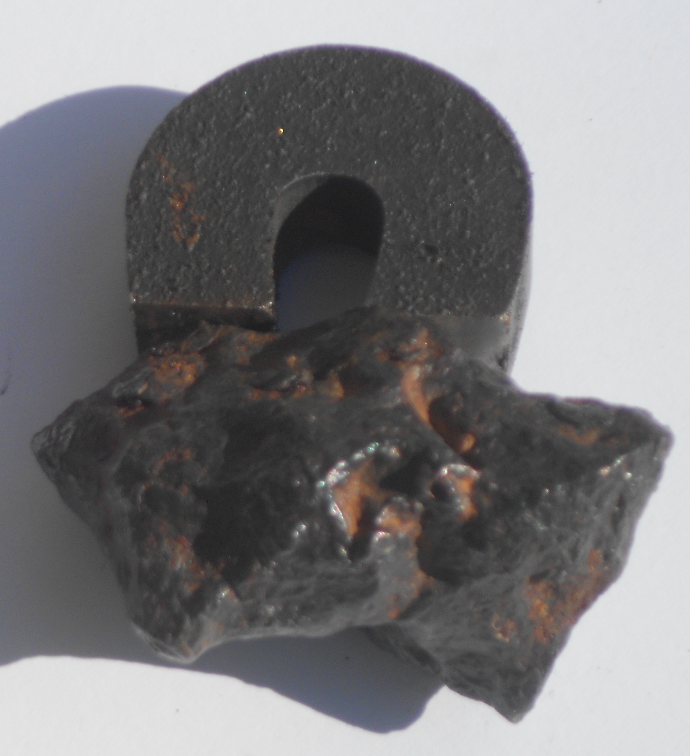 Fig. 5-5. An iron-nickel meteorite is magnetic and has a similar density as the metallic core of our planet. |
How do we know the structure of the Earth? By indirect geophysical methods! Geophysical methods use technical applications and equipment to collect information about the earth, oceans, and atmosphere that are not directly observable by our senses. Examples include:
The sections that follow explore the types of information we can learn from these three methods. |
 Fig. 5-6. Gravity can be precisely measured from orbiting satellites. |
Magnetism Measurements Reveals the Earth's Metallic CoreEarth's magnetic field is thought to be formed by flowing currents driven by the gravitational heat convection of hot, molten iron in the outer core. There must be significant amounts of iron for Earth to have such a strong magnetic field (Figure 5-7).The Geographic North Pole is currently offset from the Magnetic North Pole by about 11.5 degrees (same with the South Poles). The magnetic poles are very slowly wandering probably because the field is generated by movements in the outer core. Current the rotational (geographic) poles and the magnetic poles are about 500 miles apart. |
 Fig. 5-7. Earth's magnetic field extends from the core and far out into space. |
Magnetic Reversals - Changes In Earth's Magnetic Field Over TimeThe Earth’s magnetic field occasionally reverses, causing the locations of the north and south magnetic poles to switch. Current thought is that the magnetic reversals are caused by shifting currents in the liquid metallic outer core. Geophysical studies have shown that magnetic reversals have happened many times through geologic time. Magnetic reversals are preserved in the paleomagnetic record—a chronological record of magnetic reversals preserved as weak magnetic fields locked into rocks bearing magnetic minerals.Magnetic minerals preserve the orientation of Earth's magnetic that existed at the time they formed. For instance, when lava erupts on a volcano and then solidifies, the magnetic minerals preserved in the new volcanic rock pick up the alignment of the Earth's magnetic field at the time it formed. Magnetic reversal information preserved in rocks can be used to help define the absolute ages of rocks, and can help to interpret how far the rocks have moved since the time they formed. Discoveries revealed by paleomagnetism studies related to Plate Tectonics Theory are discussed in section 5-19 below. |
Gravity Measurementsgravitimeters are devices that measure very tiny differences in Earth's gravitational field from one place to another. Gravity measurements are also calculated measuring subtle changes in the paths of Earth orbiting satellites. Orbiting satellites are pulled closer to Earth over regions of higher gravity.Gravity measurements reveal that there must be denser material deeper in the earth. Rocks at the surface of the planet are not dense enough to account for the overall higher amount of gravitational attraction that exists between objects on the surface and objects orbiting the planet. Variations in gravitational forces also reveal subtle differences in the density and thickness of the crust in different regions of the world. Figure 5-8 shows variations in the Earth's gravitational field as revealed by satellite gravity measurements. The map shows that older and colder crust, such as under regions in the oceans, is denser (having higher gravitational attraction) than where new ocean crust is forming along mid-ocean ridges. Gravitation is less where the crust is less dense, such as beneath continental regions and where rocks are hotter (associated with regional volcanism). Gravitational forces increase with increasing mass and decreases with distance. The greater the mass between to objects (such as moons or satellites orbiting planets), the greater the gravitational attraction. In addition, the closer two objects (such as moons and planets), the greater the gravitational attraction. |
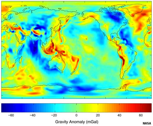 Fig. 5-8. NASA's gravity anomaly map shows subtle differences in the Earth's gravitational field in different portions of the world. Thicker masses of lower-density rocks in the crust underlie the red regions. |
Seismic Wave Data Reveal the Internal Structure of the EarthEarthquake Shadow Zones: Extensive study of shock waves of earthquakes and the global monitoring of underground nuclear bomb testing reveal information about the internal structure of the Earth. Earthquakes produce two types of shock waves: compression waves (called P waves) and shear waves (called S waves). Both S and P waves go through solids. However, S waves do not go through non-solids, so only P waves are received on the opposite side of the Earth. In addition, P waves are bent (refracted) when they cross the boundary between the solid mantle and liquid outer core. Zones of seismic wave shadows occur in the regions shown in Figure 5-9 between about 105° to 140° on the opposite side of the globe from a seismic shock. These shadow zones shows us that the Earth's outer core is liquid (molten material). In contrast, the inner core is believed to consist of solid metal, possibly similar in composition of iron meteorites. In addition, the velocity that seismic waves travel depend on the density of the material they are passing through. The denser the material, the faster the seismic waves travel. (Earthquakes are discussed more in Chapter 6.)What has research from seismic S and P waves revealed about the internal structure of the Earth? • Parts of the Earth are not solid. • The location and depth of an earthquake earthquake. • The relative strength of an earthquake. • Earthquakes only occur in the outer rigid lithosphere. • The average density of Earth. • The density and physical properties of each layer in the Earth. |
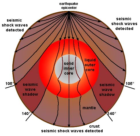 Fig. 5-9. Seismic shock waves provide information about the structure of the Earth. |
Earth’s Major Boundaries Revealed By Seismic WavesThe Moho (Mohorovicic discontinuity): (Discovered in 1909 by Andriaja Mohorovicic.)• The Moho is the physical boundary between the crust and the mantle. It separates less dense crustal rock from underlying denser upper mantle rock. • The Moho was identified by a change in the velocity of P waves. • The Moho exists at depths about 6–7 miles (10–12 km) under the ocean basins and about 24–30 miles (40–50 km) under the continents. The core-mantle boundary (CMB): (Discovered in 1914 by Beno Gutenberg.) • Based on the P-wave shadow zone. No P-wave signals from between about 105° to 140° on the opposite side of the planet from where an earthquake occurs. • The fact that S waves do not travel through the outer core provides evidence for the existence of a non-solid layer beneath the mantle. • Showed existence of liquid outer core and overlying mantle Lehmann Discontinuity (Predicted by Inge Lehmann in 1936.) • Boundary between outer and inner core defined by an increase in seismic wave velocity from outer to inner core and by seismic wave reflection off the solid inner core. The locations of the Moho, CMB, and Lehmann Discontinuity are shown in Figure 5-3. |
Seismic Wave Data Used To Map the LithosphereEarthquake data also reveals the location of major fault zones of the world (Figure 5-10). Many of the fault systems are associated with lithospheric plate boundaries (see discussion below).Fault systems evolve and change over time—movements are driven by plate tectonic forces associated mantle convection influencing the rigid lithosphere. Fault systems are often associated with volcanic regions. Faults may form and remain active for long ages before becoming inactive, and then may become reactivated again in some later period. Tectonic forces within the Earth deform rocks through processes of folding and faulting, producing mountains, valleys, and may other landscape features. (These topics are explored in more detail in Chapter 7.) |
 Fig. 5-10. Map of earthquakes of the world (USGS record for 1978 to 1987). |
Mantle Convection Moves the Earth's LithosphereGravitational heat convection in the mantle is the source of forces that move, bend, and break rocks in the Earth's lithosphere (Figure 5-11). Heat in the Earth is produced by radioactive decay of unstable isotopes as well as heat left over from when the Earth formed billions of years ago in the solar system's nebula. Gravitational heat convection within the Earth is the conclusive power source driving plate tectonic motions. (The lava lamp in Figure 5-4 perfectly illustrates gravity-driven heat convection.)Motion in the mantle is produced by heat convection—hot rocks expand and rise whereas cooler (hence denser) rocks sink. Thicker, less dense, continental crust floats higher than thinner, denser ocean crust below ocean basins. In addition, as ocean crust forms and ages with time, it cools down and its density increases. This increase in density helps old ocean crust to sink back into the mantle in regions called subduction zones (discussed below). |
 Fig. 5-11. Mantle convection is the driving force of movement in the Earth's lithosphere. |
Crustal DeformationDeformation is the action or process of changing in shape or distorting, especially through the application of pressure. In geologic terms, deformation refers to changes in the Earth's lithosphere related to tectonic activity. Heat from inside the Earth drives mantle convection (hot material rises, cool material sinks). The rise and fall of masses of material in the mantle create forces that move the rocks in the cool and brittle lithosphere near the Earth's surface. Motion within the mantle is responsible for deep crustal stretching (extension) and compression. These motions exert great forces, strong enough to rip continents apart, but the rate of movement is extremely slow on an annual basis (measurable in inches or centimeters per year).Whereas the fluid-like state of rocks in the asthenosphere move slowly, the solid, brittle material in the lithosphere builds up great pressure (stresses) and the rocks will strain under the pressure until the point that they rupture, causing earthquakes that propagates as a shock waves through the Earth. |
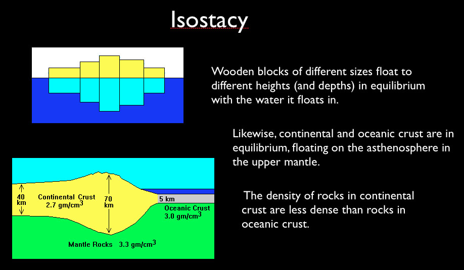

Isostasy and the Age and Evolution of Continental LandmassesMarine fossils found high in mountain ranges have been a curiosity since ancient times, however, it hasn't been until the modern era that this paradox could be explained. Many hypotheses were put forward to try to explain the evolution of landscapes—isostasy was one of them. Early hypotheses focused on what was easily observable. Continents around the world shared a variety of large physiographic features: mountain ranges, coastal plains, plateau regions, and inland lowlands. Some of these lowland regions are underlain by what appeared to be ancient rocks that were once to core of mountain ranges in the distant past. These regions were located near the center of most of the continents and have became known as shields (such as the Canadian Shield of North America, see Figure 5-25 below). In most cases, these shields are surrounded by belts of mountain ranges that were composed of rocks that are much younger than those in the shield regions. This lead to conclusions that landscapes could be classified as youthful, mature, or old-age—assuming that all mountain ranges form about the same way, and that youthful mountain ranges, like the Himalayan or Rocky Mountains, eventual erode way (becoming more mature with age, like the Appalachian Mountains). Eventually almost all elevated features (mountains, hills) completely erode away, producing old-age landscapes, similar to what is seen in shield regions (illustrated in Figure 5-16). The erosion of material from continental region contribute mass to the submerged regions along continental margins. In many regions along the continental margins the weight of additional sediments are causing them to sink (such as near the mouth of rivers like along the Gulf Coast near the Mississippi River delta).The assumption is that as materials erode away, the crust readjusts itself to maintain an isostatic equilibrium. As material is removed the crust rises. Over time, material that were once deep within mountain ranges eventually becomes exposed at the surface by erosion. Over time, the assumption was that isostatic adjustments eventually cease, and the mountains would completely erode away to a flat plain and eventually sink below the waves. Unfortunately, there were too many cases where the isostatic adjustment hypotheses didn't match all the observable facts. Not all old shield regions were low plains (as illustrated with the Scandinavian region of Europe and much of Africa). In addition, some regions, such as the Colorado Plateau, had characteristics that fit into all three categories, youthful, mature, and old age, all at the same time. In addition, there was very little to explain how mountain ranges and continents formed in the first place! Why do some mountain ranges have volcanoes and other don't? What would explain the composition and distribution of volcanic mountain ranges around the world, and what in the world could explain what chains of volcanoes like the Hawaiian archipelago were doing in the middle of the Pacific Ocean? These questions (and more) were finally resolved with the development of Plate Tectonic Theory. |
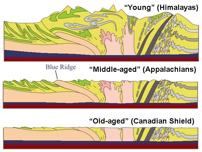 Fig. 5-16. Isostasy and the hypothesis of landscapes evolving through youthful, mature and old age stages. Evolution of a landscape over time involves uplift, erosion, and isostasy. Note that old landscapes can undergo reactivation as tectonic forces within the lithosphere change over time and location. |
Historical Observations Leading Up To Plate Tectonics Theory |
|
| Much of the background work related to the modern theory is the culmination of hundreds of years of world-wide exploration and geologic observations that go back several centuries. Highlights include: • Early Maps of the World: Maps compiled by early global explorations resulted in the observation of the matching shapes of the coastlines on opposite sides of the Atlantic Ocean. These similarities were noted from early maps by by a Flemish cartographer named Abraham Ortelius in 1596 who first suggested that it looked like the continents had drifted apart. Geographers preparing maps noted that charts of land masses that the shape continents of the world fit together like a jig-saw puzzle. It took centuries before an organized effort started to analyze the data! • Observations of the location of the world's volcanoes (maps) and lead to the recognition of the Ring of Fire (Figure 5-17). As we will see in the next chapter, the volcanoes of the Ring of Fire relate directly to Plate Tectonics Theory. • Studies that show that rocks bearing unique fossils on continents on opposite sides of the oceans supported the Continental Drift Hypothesis. |
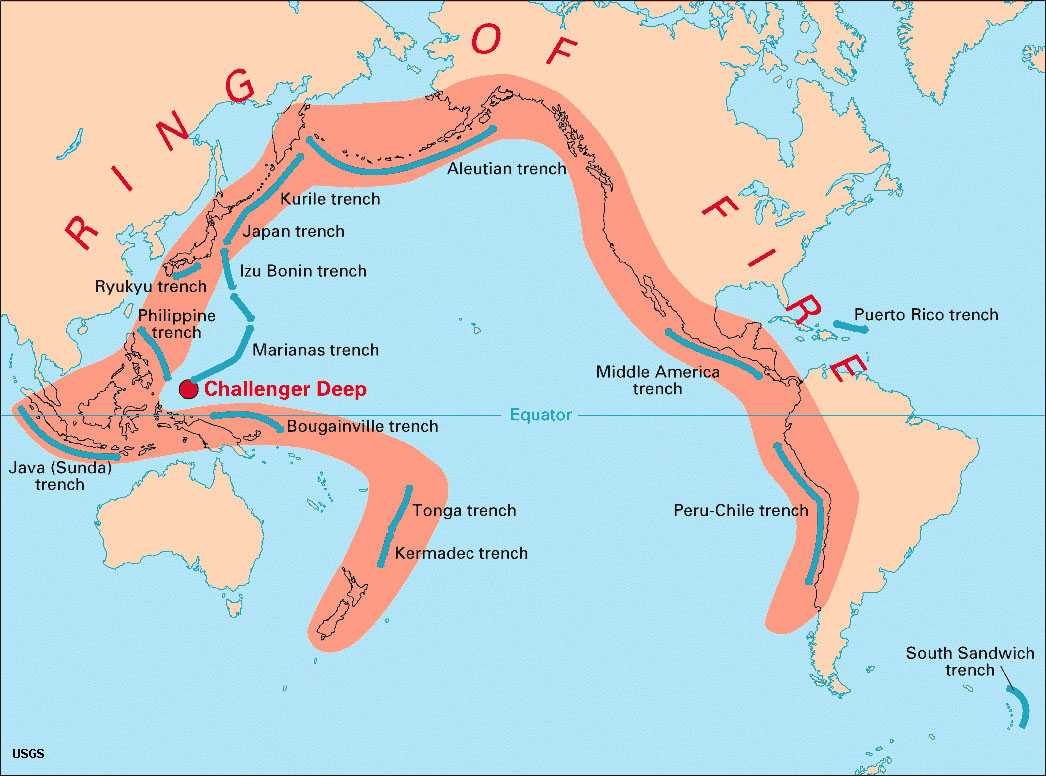 Fig. 5-17. The Ring of Fire is a zone of volcanoes, numerous earthquakes, and offshore deep trenches. |
Continental Drift HypothesisThe Continental Drift Hypothesis was a prelude to the modern Plate Tectonics Theory.The Continental Drift Hypothesis was proposed by a German astronomer and meteorologist named Alfred Wegener (1880-1930), but based on research by other earlier observers. The Continental Drift Hypothesis was based on observations that the continental coastlines on either side of the Atlantic Ocean seemed to match up. More importantly, the drift hypothesis was supported by similarities of fossils, rocks, and mountain belts on both sides of the Atlantic, as explained further below. Wegener provided intriguing geologic and fossil evidence indicated that some land masses which are now separated may have been together at some point in time. Wegener's hypothesis was that all the observable continents bordering the Atlantic and Indian Oceans had once assembled into a single supercontinent that he named Pangaea, starting about 300 million years ago. He determined that this great landmass began to break apart about 200 million years ago (Figures 5-18 to 5-20). He also said that these continents gradually started moving and separating into smaller continental landmasses and they are still moving. This is amazing because Wegener proposed this more than 100 years ago and it remains correct today. However, the hypothesis was rejected as theory by most scientists at the time, partly because it couldn't explain why it could have occurred.
|
 Fig. 5-18. Geographers noted that the continents fit together like a jig-saw puzzle.  Fig. 5-19. Fossil evidence connecting lands of Pangaea about 260 million years ago) 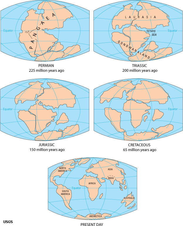 Fig. 5-20. The formation and breakup of Pangaea occurred over a period lasting 300 million years. Pangaea means all lands. It was surrounded by one global ocean named Pantalassa. More about the breakup of Pangaea is discussed below. |
The Atlantic-Pacific ParadoxEarly exploration of Atlantic Ocean basin showed that it is surrounded mostly by gentle coastal planes and old, worn down mountain ranges, and had relatively little volcanic or earthquake activity as in other regions. In contrast, the Pacific and other ocean regions were much less understood. In contrast, early exploration of the Pacific Ocean basin brought awareness of the region described as the Ring of Fire (see Figure 5-17). In most places around the Pacific Rim's Ring of Fire the transition zones of the continents to the deep ocean has large numbers of active or recently active volcanoes. This region also experiences large numbers of tremendous earthquakes. In most places where volcanic arcs (island belts and mountain ranges composed of volcanoes) appear on land, there are also very deep-water trenches located not too far offshore of the coastline.Why was Continental Drift rejected by the Scientific Community?Although Continental Drift intrigued the scientific community, it was largely rejected because there was no data to explain all the observable facts about how or why continents moved across ocean basins. This was largely because in the early 20th century very little was known about the nature of the world's ocean basins. Also, there was no knowledge of the physical characteristics of the structure of the Earth's asthenosphere and lithosphere. Many other hypotheses existed in the scientific community well into the late 20th century, but these conflicting ideas have faded in significance with the advances of the newer Plate Tectonics Theory. Wegener's hypothesis was rejected because he proposed a mechanism for continental drift, which turned out to be wrong.• His mechanism was complicated and involved the force of the earth spinning and the tides. • He was dismissed as a crank and his detractors said that he carefully picked his data to fit his hypothesis. • During Wegener's time, the entire Earth was thought to be solid, so it was difficult to formulate a mechanism for continental drift. |
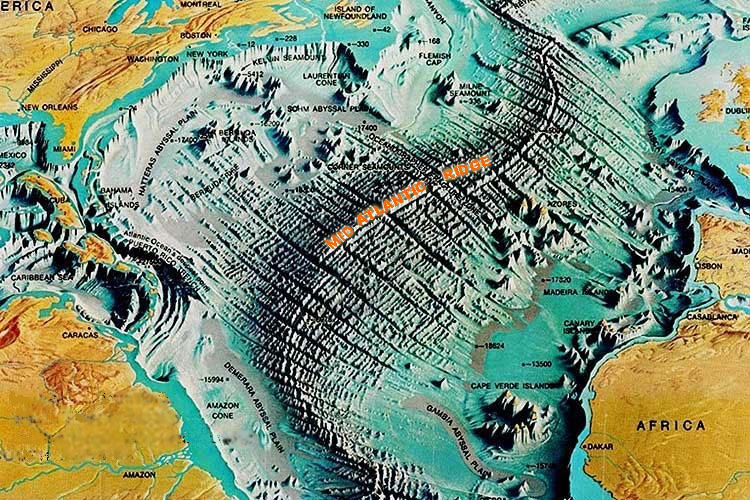
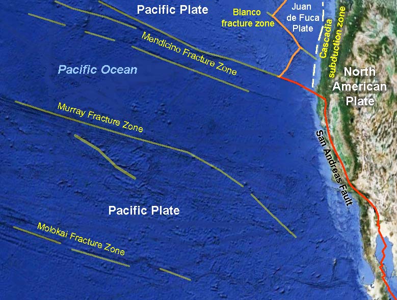
Paleomagnetism and the Study of the SeafloorEarth's magnetic field has been a curiosity since ancient times. The magnetic compass was first invented as early as the Chinese Han Dynasty (about 206 BC). The compass was used during China’s Song Dynasty for military navigation by 1044 AD, and for maritime navigation by about 1117 AD. Today, the source of the magnetic field is presumed to be from the movement of molten iron and metals in the Earth's core. The spinning of these liquid metals produces electric currents in the same manner as an electric coil produces a magnetic field. The magnetic field extends into space (see Figure 5-7). Over time, these currents fade, change direction, or intensify elsewhere, causing the magnetic poles to migrate or reverse the magnetic polarity of the entire planet (events called magnetic reversals).Magnetometers (devices used to detect and measure the strength of magnetic fields) were used in World War II to search for submarines. It was noted from these investigations that the seafloor preserved large magnetic anomalies that lined up parallel the Mid-Atlantic Ridge (Figure 5-23). These investigations showed that the Earth's magnetic field has reversed many times through Earth history; magnetic reversals happened over periods ranging from thousands to millions of years. Paleomagnetism (old magnetism preserved in rocks)As rocks (with iron in them) solidify, the magnetism direction points to the Magnetic Pole (currently north). However, over time, the magnetic poles (both north and south) are slowly migrating, and sometimes reverse. The magnetic polar reversals have happened many times in earth history, and their ages are now well known from supporting data provided by absolute dating methods. Paleomagnetism studies provide important data for resolving the age of rocks, where they formed, and where and how they have traveled over time. This information derived from old rocks is good for resolving latitude as continents have moved across the globe over time, and in some cases, where continents have slowly rotated over time.Paleomagnetism is the study of the fixed orientation of a rock's magnetic minerals as originally aligned at the time of the rock's formation. Paleomagnetism is usually the result of thermoremanent magnetization (magnetization that occurs in igneous rocks as they cool below a certain temperature (called the Curie Point). Igneous rocks may keep their magnetic orientation they obtain at the time they form (if they are not altered). This magnetic signature is preserved, even if the landmass the magnetic rocks are moving. Mapping of the seafloor with magnetometers revealed lines of rock preserving history of magnetic reversals running parallel to the mid-ocean ridges [first published by Vine & Matthews, 1963] (Figure 5-24). With decades of studies of paleomagnetism of seafloor rocks and volcanoes around world the chronology of magnetic reversals through geologic time are now well known. Seafloor SpreadingSeafloor spreading is the processes associated with the formation of new areas of oceanic crust. Seafloor spreading occurs through the upwelling of magma along mid-ocean ridges and its subsequent outward spreading movement on either side. As new rock forms along mid-ocean ridges it becomes attached to the lithospheric plates on either side of the spreading centers. Because the Earth's magnetic field is reversing frequently through geologic time, the rocks forming and moving away from spreading centers preserve the pattern of preserved magnetic orientation. This pattern turns out to be mappable (Figures 5-23 and 5-24).Paleomagnetic studies of the world ocean basin resulted in the discovery of mid-ocean ridges and spreading centers. These undersea mountain ridges extend for 10s of thousands of miles beneath portions of the global ocean basins (see Figures 5-10, 5-21, and 5-26 below). Seafloor spreading became a mechanism to explain continental drift. However, seafloor spreading alone does not explain the formation of continental landmasses through geologic time. Mid-ocean ridges are sites with active volcanism and mild earthquakes. They display a thin sediment cover because ocean floor is being newly formed. Volcanic rocks along mid-ocean ridges are basaltic composition. Mid-ocean ridges are also locations where hot water vents occur on the seafloor. |
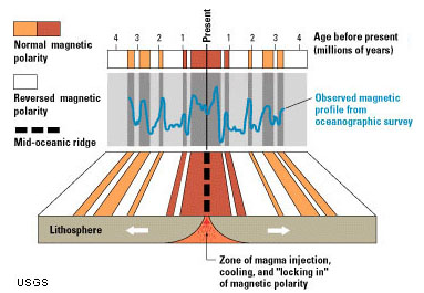 Fig. 5-23. Mapping of the seafloor with magnetometers revealed lines of magnetic reversals on opposite sides of mid-ocean ridges. (USGS)  Fig. 5-24. West Coast magnetic reversals reveal the location of spreading centers and fault boundaries in the ocean basin offshore of California, Oregon, Washington, and British Columbia. |
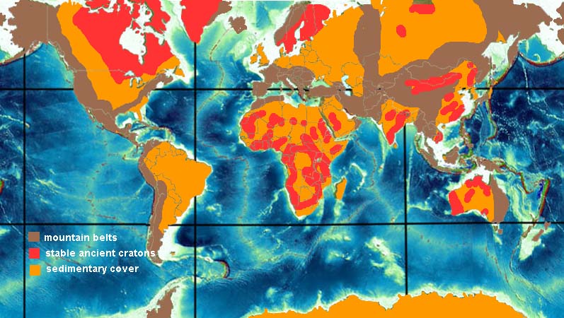
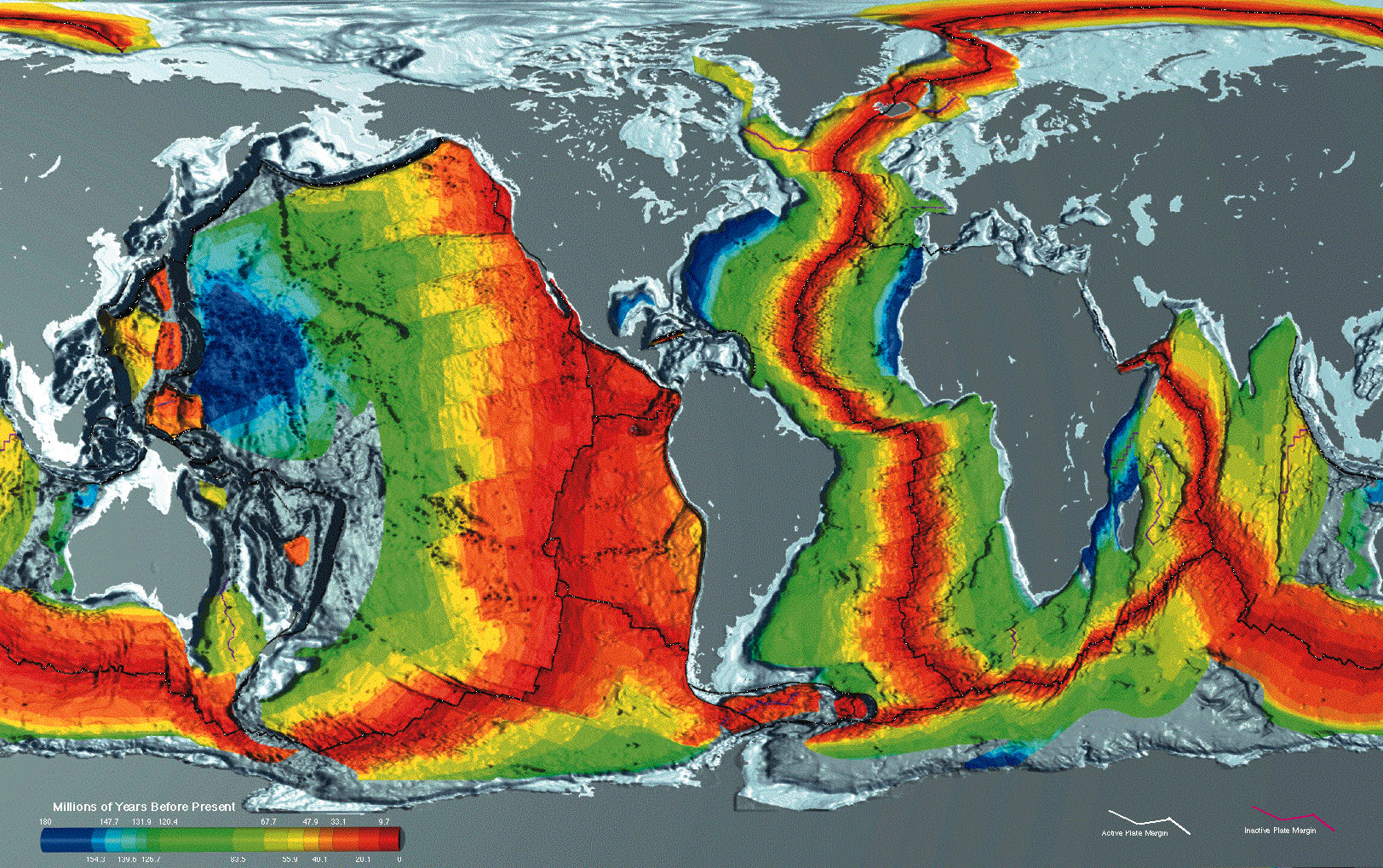
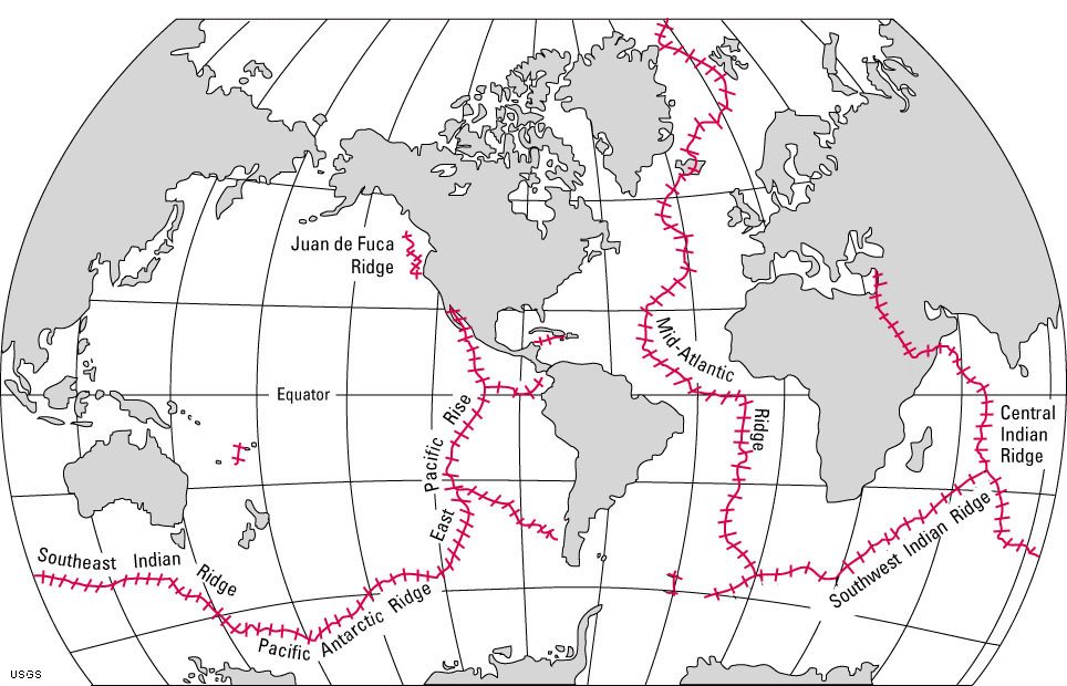
Plate Tectonics TheoryPlate Tectonics Theory explains the large-scale motions of Earth's lithosphere. Plate tectonics theory builds on concepts of Wegener's Continental Drift Hypothesis. It was the global efforts of seafloor exploration following World War II resulted in the development of seafloor spreading theories in the late 1950s and early 1960s. This exploration effort involved perhaps many thousands of scientists within the global geoscience community (geologists, oceanographers, paleontologists, and geophysicists, assisted by world leaders) who systematically gathered information and mapped the world, both on land and underwater. The mechanics of Plate Tectonics Theory were largely resolved as large quantities of data about the age and distribution of rocks beneath the ocean basins were compiled from ocean drilling programs and geophysical studies of the ocean crust from around the world. Seafloor mapping, along with the study of volcanoes and earthquakes provided the evidence to support plate tectonics theory.Plate Tectonics Theory helps to explains to some degree almost all things geological in the observable world, past and present. Plate tectonics expounds that Earth’s outer shell (lithosphere) is composed of several large, thin, relatively rigid plates that move relative to one another (Figures 5-28). The theory of plate tectonics helps explain the location of the world's volcanoes and earthquakes. The theory combines elements of continental drift and seafloor spreading. The theory suggests that the lithosphere is divided into pieces, called lithospheric plates, and that denser ocean crust sinks below less-dense continental crust along subduction zones. Movements along fault systems that define lithospheric plate boundaries produce most observed earthquakes. The different kinds of plate boundaries are discussed below. Note that many of the plates on Figure 5-28 include both continental and oceanic lithosphere. |
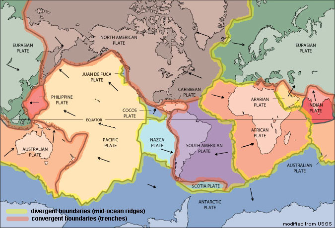 Fig. 5-28. Map showing the location of lithospheric plates and plate boundaries of the world. Boundaries shown in yellow are divergent boundaries, Those in orange are convergent boundaries. Note that some plates include both continental and oceanic crust. |
How Plate Tectonics WorksOver time, the newly formed ocean crust cooled and moved slowly away from the mid-ocean ridges (see Figure 5-27). These areas where new crust is forming and moving apart are called spreading centers. New ocean crust forms and moves away from spreading centers over time (as inferred from Figure 5-26). Since new ocean crust is forming, old crust has to be disappearing somewhere, and it turned out that the old crust was sinking back into the mantle along extensive fault zones associated with the deep ocean trenches. Earthquakes caused by friction along the subduction zone reveal that crust is slowly sinking back into the mantle. These great fault systems are called subduction zones (illustrated in two plate-tectonics models, Figures 5-29 and 5-30). Subduction zones are locations where cool and dense ocean crust sinks back into the mantle (asthenosphere). As the crust sinks it gradually heats up. Water and gases trapped in the sinking crust cause partial melting (forming magma) which rises (due to its lower density through zones of weakness in the lithosphere). Some of this rising magma accumulates in magma chambers, whereas some of it may actually rise all the way to the surface to form volcanoes.Figure 5-28 is a map of Earth's lithospheric plates (the inferred plate boundaries around the world). As shown in Figure 5-26, new ocean crust is forming along spreading centers along mid-ocean ridges, and subduction zones are where old ocean crust is being destroyed or recycled; some of it is incorporated into new continental crust above subduction zones. Spreading centers and subduction zones are mapped as plate boundaries (see Figure 5-28). However, other features are also considered plate boundaries where crust is neither forming or being destroyed, but are rather moving past each other or crushing into each other. These regions have earthquakes but little or no volcanic activity. Examples where this is taking place include the San Andreas Fault in California (a transform plate boundary) and the Himalayan Mountains between where India and Tibet are crashing into each other (discussed below). |
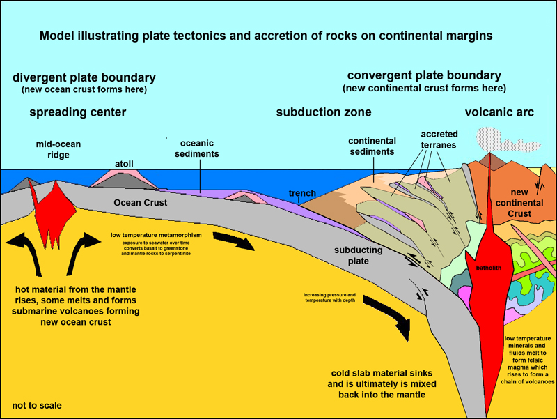 Fig. 5-29. A cross-section model illustrating plate tectonics: formation and destruction of ocean crust.  Fig. 5-30. A simplified model of plate tectonics showing types of lithospheric plate boundaries. |
| Watch a video about the Pacific Ring of Fire and Its Earthquakes (and Volcanoes) (YouTube video) |
Three Types of Lithospheric Plate BoundariesThere are general types of lithospheric plate boundaries (see Figures 5-28 to 5-30).Divergent boundary (where plates are pulled apart by tensional forces)—When plates diverge, spreading centers form creating new oceanic crust. Examples include mid-ocean ridges in world's ocean basins. Spreading centers also occur where continents are pulling apart. Examples where spreading center activity is spitting continents apart include the Africa rift zones, Red Sea basin, and North America's Great Basin region including the Gulf of California (see Continental Rifting discussions below). Convergent boundary (where plates are pushed together by compressional forces)—When lithospheric plates collide... mountains belts form - examples include the Himalayas, Alps, and ancient Appalachian Mountains when the ancient continent of Pangaea formed. When continents collide with ocean crust... subduction zones with deep ocean trenches and volcanic arcs form - examples include the Andes Mountains, Aleutian Islands, Japan, Philippines, Indonesia, the ancient Sierra Nevada and modern Cascades Range in northern California, Oregon, and Washington. Transform boundary (where plates slide past or are rotational)—When plates slide past each other creating fault systems along plate margins. Examples include the San Andreas Fault in California and major faults in Pakistan, Turkey, and along the Jordan River/Dead Sea. |
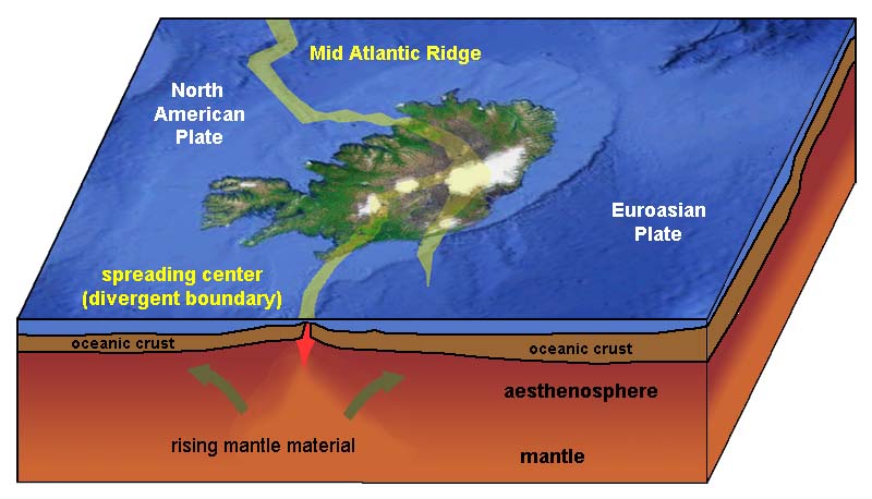
Divergent Plate BoundariesDivergent plate boundaries are locations where tensional forces are pulling things apart. In locations where lithospheric plates are diverging, the rates of divergent motion range from 2 to 17 cm/year.Spreading Centers along Divergent Plate BoundariesA spreading center is a linear area where new crust forms where two crustal plates are moving apart, such as along a mid-oceanic ridge. Spreading centers are typically seismically active regions in ocean basins associated with mid-ocean ridges (MOR) and may be regions of active or frequent volcanism (Figure 5-31). Spreading centers are associated with divergent plate boundaries. The youngest rocks on the ocean floor are mostly located along mid-ocean ridges.Iceland is host to an active spreading center that is exposed above sea level (Figure 5-32). |
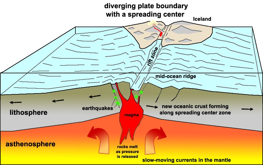 Fig. 5-31. Formation of new oceanic crust along a spreading center associated with a mid-ocean ridge. Some spreading centers appear on land. For example, a portion of the Mid-Atlantic Ridge is exposed above sea level on Iceland. |
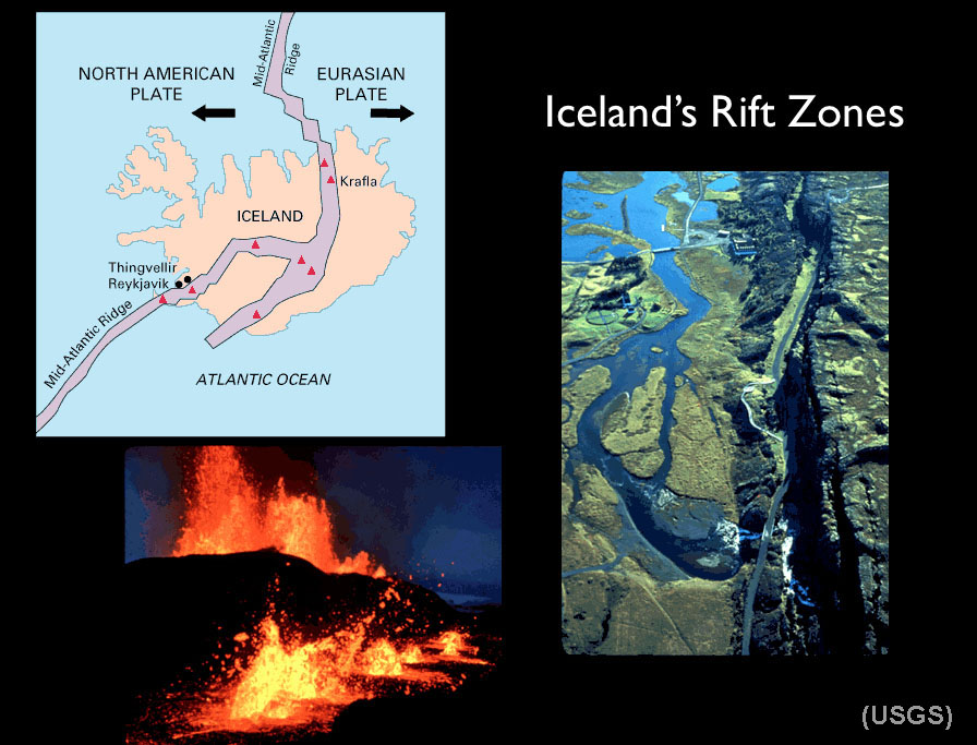 Fig. 5-32. Iceland's is an exposed portion of the North Atlantic spreading center. Iceland is splitting along a rift zone where new crust is forming. Of 130 volcanoes on the landmass, 30 are currently considered active. |
Seafloor SpreadingFormation of New Ocean Crust at Divergent Plate BoundariesSeafloor spreading features and processes include the following:• Involves oceanic crust (OC) only. • Tensional forces generated by gentle flow in the upper mantle gradually pulls oceanic crust apart (forming faults that split deep into the newly forming ocean crust). • Volcanic activity along faults and fracture zones allows magma to rise cool on or near the seafloor surface. • This volcanic activity generates new seafloor/oceanic crust. • This forms a mid-oceanic ridge (MOR) where faulting and volcanism is most active. • Over time, older oceanic crust moves away from a spreading center as new ocean crust is formed along the MOR. • Youngest oceanic crust is found near the ridge, oldest (and colder) crust is farther away from the ridge. • Uplifts occurs as the new, hot ocean crust as it is rifted, so MORs are typically the shallowest part of deep ocean basins. • The MOR is symmetrical about the ridge; new crust accumulates on both sides of the ridge. • Evidence of magnetic reversals are preserved in volcanic rocks found along MORs worldwide. • Marine sediments deposited on top of new ocean crust thicken away from the ridge as crust grows progressively older. • Hydrothermal vents (vents of hot water called black smokers) are found along spreading centers. Ocean Rises vs. Ridges Along Spreading Center ZonesSpreading center are active at different rates, resulting in different physical characteristics.A rise spreads faster and is less steep, a ridge is steeper and spreads slower. Examples to compare: • East Pacific Rise (Figure 5-33, also see Figures 5-26 and 5-30) • Mid-Atlantic Ridge (see Figures 5-21, 5-26, and 5-31). • On Iceland, the MOR rises to the land surface, its rate of spreading is about 15 cm/yr (Figure 5-32). |
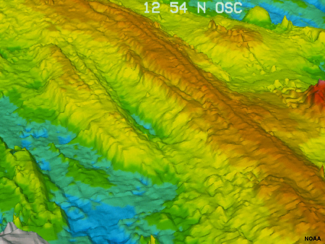 Fig. 5-33. The East Pacific Rise is a rapidly forming spreading center (a mid-oceanic ridge that separates the Pacific Plate to the west from (north to south) the North American Plate, the Rivera Plate, the Cocos Plate, the Nazca Plate, and the Antarctic Plate. See Figure 5-30. |
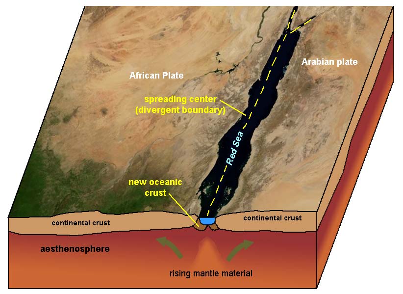
Continental RiftingContinental Rifting occurs where divergent boundaries form within continental landmasses:• Involves rifting (pulling apart) of continental crust (CC) only. • Forms possibly from convection in the asthenosphere • Large amounts of sediments are usually produced in continental rifting zones. • Initially, when a continental rift forms it has continental processes such as the formation of large lakes, rivers, and beaches. Later, as it pulls farther apart it can become an oceanic rift when sea water floods in. It then becomes a MOR. Present continental rifts include: • Red Sea and East African Rift System (Figure 5-34 and 5-35). • The breakup of Pangaea began with continental rifting starting about 200 million years ago with Africa pulling apart from North and South America. It eventually flooded with seawater and became the new Atlantic Ocean Basin. |
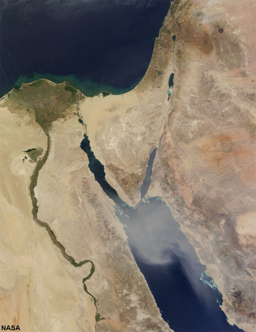 Fig. 5-34. Continental rifts along the Red Sea and Sinai Peninsula (Jordan River, Dead Sea) |
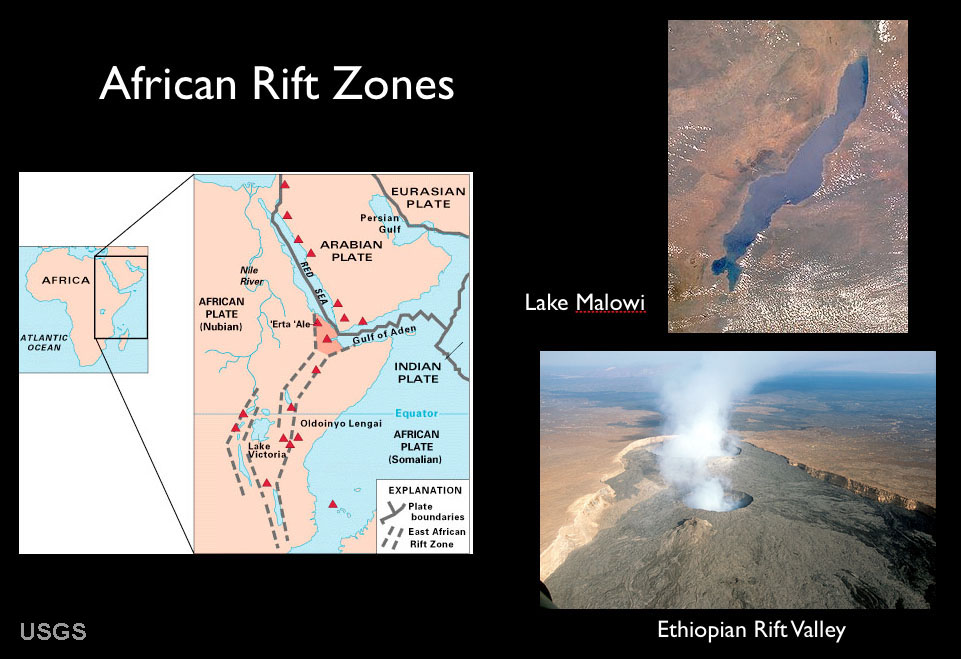 Fig. 5-35. Africa rift zones are zones where the African continent are being pulled apart. The African Rift basins are spreading centers that are the location of large inland lakes and much volcanic activity. One day in the distant future become seas like the modern Red Sea. |
Crustal Extension and Continental RiftingCrustal extension occurs where a divergent plate boundary develops under a continental landmass on a large scale, associated with continental rifting (Figure 5-36).Both crustal extension and continental rifting are occurring in northern Gulf of California and throughout North America's Great Basin region under Nevada, Arizona and eastward into the Rio Grand River rift valley in New Mexico (Figure 5-37). As the Atlantic Ocean opened, the North American continent was pushed over a spreading center that is now the entire region of Utah, Nevada, Arizona, and parts of New Mexico. Baja California and the Peninsular Ranges of San Diego and Orange counties have been rifted away from the Mexican coastline gradually over about 23 million years. Baja will continue moving northward, eventually crushing into southern Alaska in the distant future! |
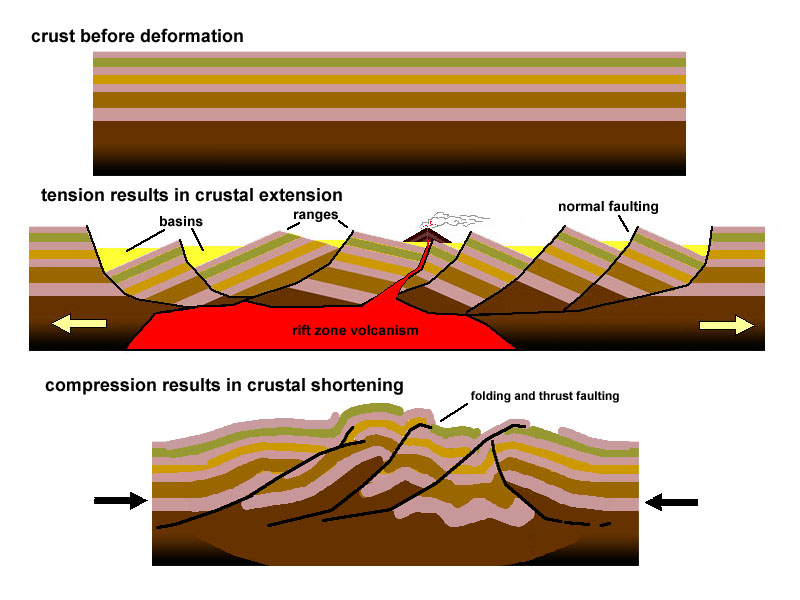 Fig. 5-36. Crustal extension creates a thinner crust and rifting. Crustal compression creates a thicker crust and mountain building. |
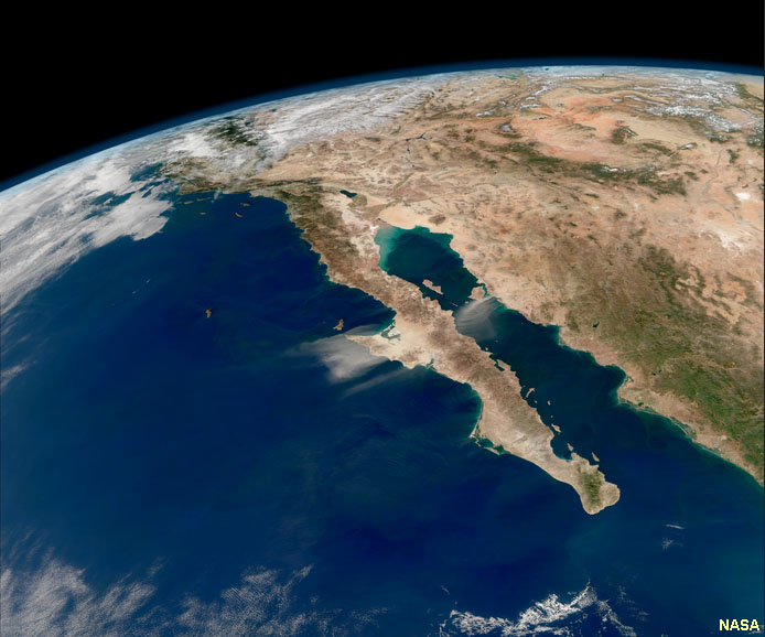 Fig. 5-37. Gulf of California and Great Basin—a region where crustal extension is occurring. |
Convergent Plate BoundariesConvergent Plates move together and collide so you have compressional forces. They are associated with active margins—locations where mountain building is occurring, resulting in numerous earthquakes and andesite (explosive) volcanoes. Most mountain ranges on continents form as a result of convergence and associated crustal compression and volcanism.
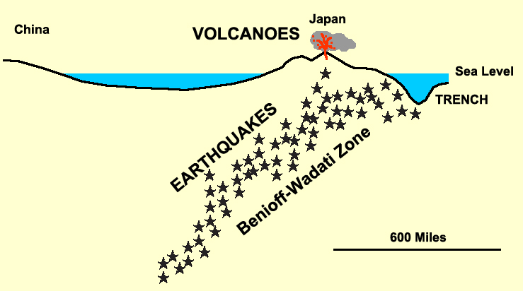
Figure 5-38 illustrates how earthquake data reveals the geometry of a subduction zone. This diagram show the location and intensity of earthquakes over a period of time in the vicinity of the Tonga Islands in the South Pacific Ocean. A deep ocean trench runs along the southeast side of the island chain. Earthquake data shows that a major fault system descends at an angle, extending eastward beneath the Tonga Island and extends of hundreds of kilometers at a steep angle deep into the upper mantle (asthenosphere) where it is presumed that earthquakes cease because rocks are too hot and under intense pressure that it easier for them to fold and flow plastically than to fracture as brittle rock. The earthquake data suggests that the eastern edge of the Australian Plate is being over run by the western edge of the Pacific Plate, and that rocks of the Australian Plate are descending into the upper mantle. |
 Fig. 5-38. Earthquake data reveals the geometry of a subduction zone in the region of Tonga. Almost all deep-focus earthquakes occur along or near convergent plate boundaries. |
Three types of Convergent Plate Boundaries: OC/CC, OC/OC, & CC/CCThree types of convergent plate boundaries are recognized: .a) Subduction of ocean crust (OC) beneath continental crust (CC) b) Subduction of ocean crust (OC) beneath ocean crust (OC) c) Continental Collisions: continental crust (CC) colliding with continental crust (CC). |
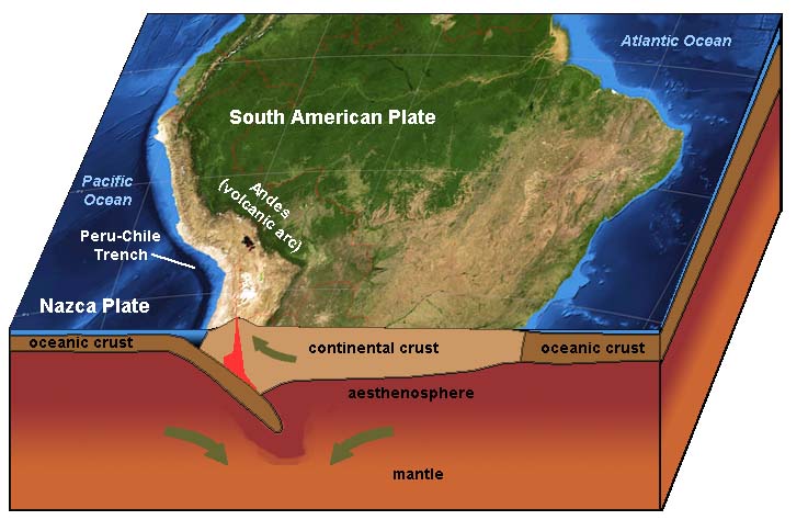
a) Subduction of ocean crust (OC) beneath continental crust (CC).• Denser, thinner OC is pushed or subducted beneath less dense and more buoyant CC.• A chain of volcanoes formed, called a continental volcanic arc. • Subduction produces both deep and shallow focus earthquakes (with tsunami potential); the largest ever--9.5 magnitude in Peru/Chile Trench in 1960. • Volcanoes of the andesite (explosive) type. Examples include the Andes and the Cascade Range , etc. • Deep trenches form around continents margins. Trenches are especially well developed in regions far away from spreading centers (where the ocean crust is old, cold, and denser, and therefore sinks more rapidly). • Subduction reduces amount of (and destroys) OC. • Rates of subduction are up to 15 cm/yr in the active margins of the Pacific Basin. Examples: • Andes in South America (Figure 5-39) • Cascades in United States (include such volcanoes as Mt. St. Helens, Mt. Rainier, Mount Shasta, Crater Lake and many others) |
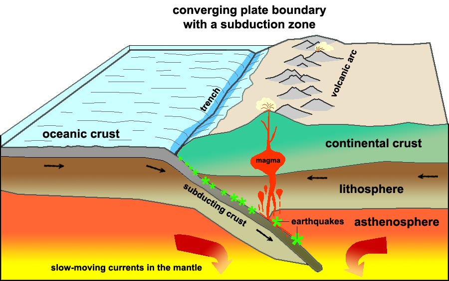 |
| Fig. 5-39. Subduction zone geometry (OC/CC) is revealed by the location of earthquakes and volcanic activity. Subduction zones are where oceanic crust is destroyed and new continental crust forms. Subduction zones associated with ocean trenches surround much of the Pacific Ocean Basin. |
b) Subduction of ocean crust (OC) beneath ocean crust (OC).• Many similar features as above [OC/CC].• Denser, older, cooler OC is pushed or subducted beneath less dense, warmer, younger OC. • Forms island volcanic arcs. • Deep and shallow (tsunami potential) focus earthquakes • Volcanoes not as explosive as above with OC/CC, as there is no mixing of CC rocks (called granites). Volcanic rocks are mostly basaltic in composition. • Subduction reduces amount of (and destroys) OC. Examples: •Japan, Tonga Islands, and Aleutian Islands (Alaska)(Figures 5-40 and 5-41) |
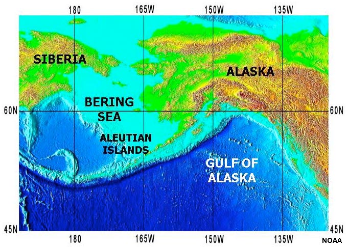 Fig. 5-40. Aleutian Islands and Aleutian Trench. |
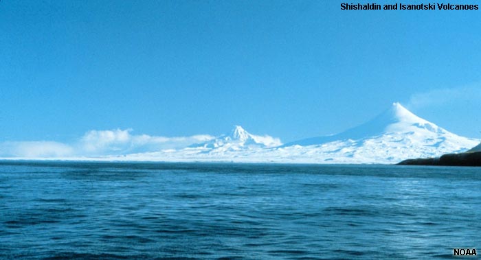 Fig. 5-41. Volcanoes of the Aleutian Islands volcanic arc are forming where the Pacific Plate is subducting beneath ocean crust under the Bering Sea region. |
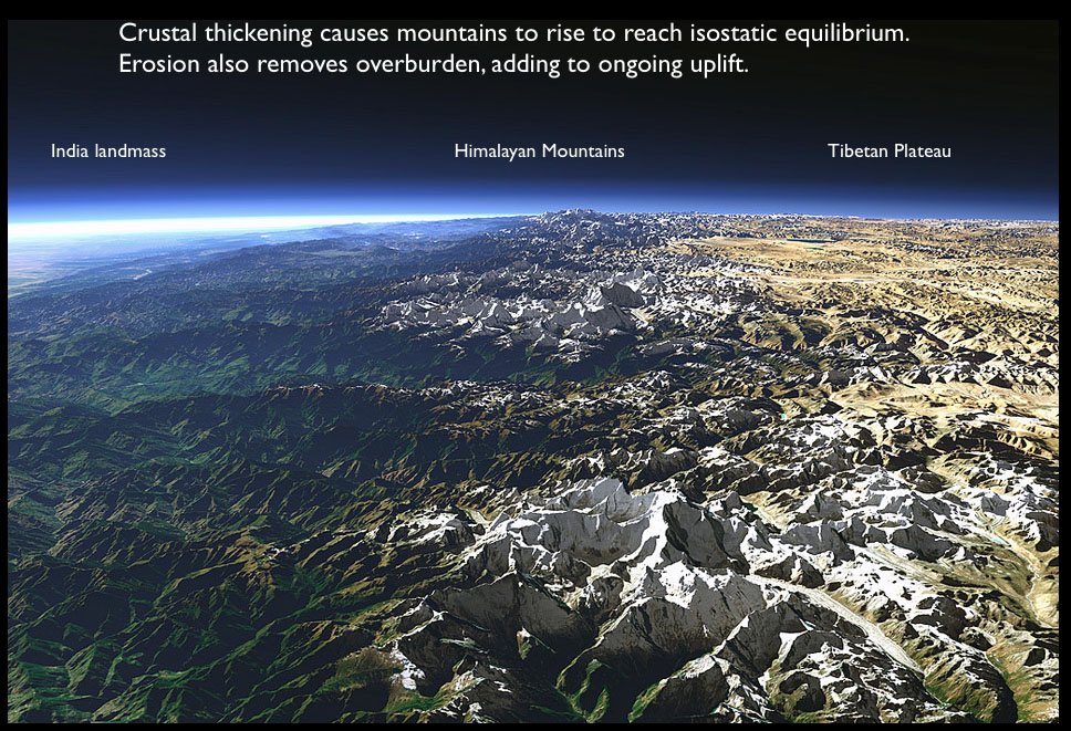
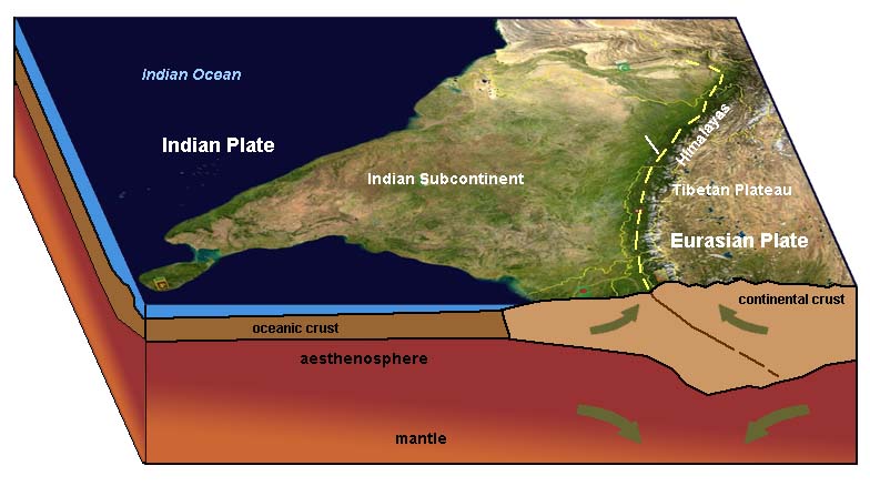
c) Continental Collisions: continental crust (CC) colliding with continental crust (CC)When continents collide with other continental landmasses:• Neither of the CC are subducted, • Both are very buoyant and want to "float" or ride high. • This is where you form the very large mountain chains. • Mountain building occurs with lots of earthquakes; massive erosion also occurs. Examples: • Himalayas Mountains (India) began forming when the Indian land mass began to collide with the Eurasian Plate (Figure 5-42). The mountain range is rising because the light continental crust of both the Indian continent and within the Tibetan Plateau aren't dense enough to sink into the mantle. • Alps Mountains are being pushed up by collisions between Africa (and Italian Peninsula) with Europe. • Appalachians Mountains in the eastern United States (formed when North America collided with Africa about 350-400 million years ago (before the Atlantic Ocean opened later). |
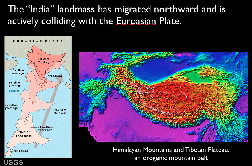 Fig. 5-42. Migration of India away from ancient Pangaea has led to the collision of continental land masses resulting in the rise of the Himalayan Mountains. In this region, the continental crust on both sides of the plate boundary are too light to sink into the mantle. |
Examples of Plate Boundaries |
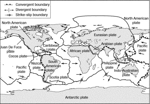 |
Figure 5-44. Characteristics of Plate Boundaries Note that the divergent boundary in the middle of the Atlantic Ocean separates multiple lithospheric plates: North and South American plates to the west, and the African and Eurasian plates to the east. All four of these plates contain both continental and oceanic crusts. The Pacific plate is almost entirely made up of oceanic crust. The movement of the Pacific Plate away from the East Pacific Rise divergent zone results in the major subduction zones on the northern and western side of the Pacific Ocean basin. The Nazca plate is moving directly eastward and colliding along the convergence zone with the South American Plate, with subduction resulting in the formation of the Andes Mountains Volcanic Arc. These regions along the Pacific Ring of Fire are responsible for most of the major earthquakes in the past several centuries. Unfortunately, this mercator map projection thoroughly distorts the plate boundary characteristics for the polar regions. |
| Convergent boundaries | Divergent boundaries | Transform boundaries |
When continents collide mountains belts form. Examples:
|
When plates diverge, spreading centers form creating new oceanic crust. Examples:
|
When plates slide past each other creating fault systems along plate margins. Examples:
|
 |
 |
 |
| Fig. 5-45. Himalayan Mountains are a convergent plate boundary | Fig. 5-46. Mid Ocean Ridge in Iceland is a divergent plate boundary | Fig. 5-47. San Andreas Fault system is a transform plate boundary |
| When continents collide with ocean crust trenches with subduction zones and volcanic arcs form - examples:
|
Spreading centers occur where continents are pulling apart. Examples:
|
Transform faults also occur within plates, but are related to movements that shape the seafloor. Examples:
|
 |
 |
 |
| Fig. 5-48. Convergent boundary along the west coast of South America | Fig. 5-49. A divergent boundary forming in the Red Sea area | Fig. 5-50. Transform fracture zones offshore of California are within the Pacific Plate |
Important! Continental margins may or may not be plate boundaries!For example, the East Coast is in the middle of the North American Plate. Why? When North America first split away from Africa and Europe, there was first a continental rift valley; it then became a plate boundary between the three expanding lithospheric plates. As new crust formed along the Mid Ocean Ridge spreading center, it became attached to the plates on either side. Today the North American Continent is part of the larger North American Plate! (See Figure 5-30.) The eastern edge of the North American Plate is along the Mid Atlantic Ridge. Passive margins like North America's Atlantic and Gulf Coast regions are not plate boundaries, but they started forming as divergent boundaries (rift basins) long ago when continents were assembled together as the supercontinent Pangaea. |
||
Hotspots and Mantle PlumesA hotspot is a place in the upper mantle of the Earth at which extremely hot magma from the lower mantle upwells to melt through the crust usually in the interior of a tectonic plate to form a volcanic feature.• These are hotspots beneath the lithosphere caused by rising plumes of hot mantle material. • Can form volcanoes on surface (examples include Hawaii and Yellowstone hotspots (Figures 5-51 and 5-52). -Volcanoes are mostly mafic (basaltic) as these lavas are very hot and very fluid from deep sources. -Less common are felsic (rhyolitic) magmas as they are thicker and less prone to flow. • Hotspots can occur beneath any crustal type (OC or CC). • Where they form a trace consisting of a chain of volcanoes (like in Hawaii's Emperor Seamount Chain, Figure 5-49) • Hotspots can exist in about the same place for 10's of millions of years • The Hawaiian Hotspot has existed for about 60 million years; the youngest part of the Emperor Seamount Chain. • The oldest part of the Emperor Seamount Chain has already been subducted (destroyed). • There are hundred of hotspots located around the world. Some are larger and more active than others. • Most hotspots are located under the interior sections of lithospheric plates, but some occur near divergent plate boundaries. • Paleomagnetism in rocks on the ocean floor associated with hotspots provides a method for determining speed and direction of plate motions. • We are not sure of the exact mechanism that forms hotspots, there are some ideas (see below). Yellowstone National Park's Hotspot:• The Yellowstone hotspot currently under continental crust (Figure 5-52).• Yellowstone is a very large and complex supervolcano. The Yellowstone supervolcano is at the eastern end of a long chain of progressively older supervolcanoes that formed along the trace of the Snake River Plain (Idaho, Washington, and Oregon) • The hotspot had formed volcanoes of both basaltic and rhyolitic composition. • Has had large rhyolitic eruptions 3 times in the last 2 million years • This hotspot appears to have been present for less time than the Hawaiian hotspot (about 17 million years). |
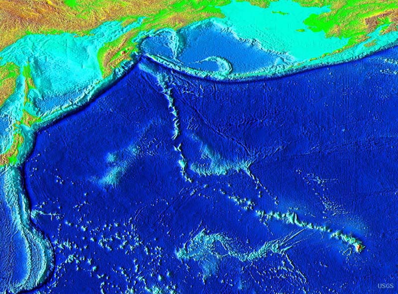 Fig. 5-51. Map of the Hawaiian Hotspot and the Emperor Seamount Chain in the Pacific Ocean basin. 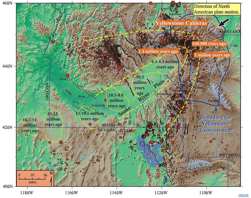 Fig. 5-52. The Yellowstone Hotspot is beneath the North America continent and is slowly migrating eastward as the continent is moving westward. |
Hot topic! Are hotspots related to astroblemes (large asteroid impacts)?Earth has been hit by many asteroids throughout the geologic past; some were very large. If Earth didn't have an atmosphere and active plate tectonics it would appear heavily cratered like the moon!Current research suggests that massive asteroid impacts can deeply penetrate and fracture the lithosphere, allowing craters to flood with lava—the magma generated by both the impact and material flooding upward to the surface from deeper down. The question is, do astroblemes turn into hotspots? Also, it has been suggested that shock waves from a massive impact can travel through the Earth and will concentrate energy at the antipoles (the opposite side of the Earth), resulting in deep fracturing of the lithosphere, and sometimes resulting in massive volcanic eruptions. Examples of two possible antipole eruptions include the formation of the Deccan Traps in India (opposite the K/T boundary impact ~66 million years ago in the Yucatan region of Mexico. Another massive flood eruption occurred about 250 million years ago, forming the massive Siberian Traps (massive flood basalts that formed about the time of the great end-of-Permian extinction). |
What drives plate motions?• Researchers generally agree that gravitational heat convection is the primary force behind plate tectonic activity (Figure 5-53). However plate motion is also influenced by the formation of the lithosphere.Forces that drive plate motion: • Slab-pull - the slow movement of the material in the upper mantle from a location where it is rising to a location to a sinking location pulls along the rigid lithosphere above it. • Slab-suction - The higher density of old cold, ocean crust that is sinking into the mantle pulls upper crustal rocks and seafloor sediments along with it. • Ridge-push - new ocean crust forms along mid-ocean ridges, it is warm and tends to rise above the ocean floor, pushing older, cooler crust away. |
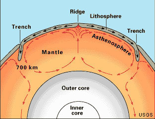 Fig. 5-53. Mantle convection is the driving force of motion of lithospheric plates. Much of the convection motion may be in the upper mantle, but it is likely to extend deep into the earth's molten outer core. |
Importance of Plate Tectonics (A Review)Plate tectonics model explains many aspects of the geometry of continents and ocean basins and the processes creating new oceanic and continental crust. Material that does not become incorporated into the lithosphere sinks and becomes incorporated back into the mantle.• The theory provides explanations for many of earth’s major processes. • The theory combines elements of continental drift and seafloor spreading. • Explains the geologic distribution of earthquakes, volcanoes, and mountains • The theory demonstrates that Earth's lithosphere is subdivided in to large plates with major geologic processes occurring mostly along their margins. • The theory demonstrates that new crust forms along divergent boundaries, and older ocean crust is subducted along convergent boundaries. • Explains the distribution of ancient organisms and mineral deposits • Plate tectonics are responsible large volumes of oil and gas deposits we use today. Think about how your life and society would be different if we only had a mere fraction of the hydrocarbons we currently have and use. |
| How does Plate Tectonics explain why continental landmasses are so old (compared to ocean crust)? The interior of the earth is very hot—the source of this heat is thought to be left over from the formation of the planet several billion years ago. As shown in Figure 5-53, the combined effect of the internal heat of the Earth and the force of gravity drive gravitational heat convection currents within the Earth. Heat things up, they expand, become less dense, and the material rises. Cool things down, they condense, increase in density, and the material sinks. This can be easily demonstrated the way hot air balloon rise and fall, or the way currents move when water is heated, or the way currents within a boiling pot of soup rises and sinks when it cools (Figure 5-54; or like the lava lamp in Figure 5-4). When new ocean crust forms in spreading centers, it is still hot for a time, but it eventually cools by having contact with the cold, deep ocean waters. As a result, old ocean crust is enriched in dense minerals. As it ages, it also absorbs water from the ocean and is becomes blanketed with marine sediments. Where subduction takes place, cold, dense ocean crust sinks back into the mantle. However, as the old crust sinks, it heats up and some of the materials within it melts (assisted by the presence of water and other gases). The materials that melt rise as hot fluids (magma and gases) through the overriding continental crust, forming large magma filled chambers that eventually crystallize into rock at depth, some of which erupts at the surface to form volcanoes. The new rocks that form along the continental margins are less dense than the original oceanic crustal rocks, therefore they eventually isostatically float and rise above the ocean surface, becoming land. Over time, more and more of this lighter rock accumulates first forming volcanic island chains. These volcanic arc and the sediments they shed eventually becomes scraped off and crushed onto the margin of continents—often pushed up as coastal mountain ranges. It this manner, continents grow slowly around their margins in a process called accretion. This process explains why the oldest rocks occur in the shield regions of continents and younger material occurs along continental margins. |
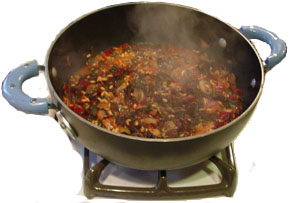 Fig. 5-54. Currents in boiling soup demonstrates gravitational heat convection. The "broth" rises, cools, and sinks (like the formation and destruction ocean crust over time). In contrast, the bubbly "froth" builds up in patches over where cool soup sinks back into the pot. The buildup of froth in patches is similar to the way continents build up over time. |
Continental Accretion - The Origin of ContinentsAccretion is a process by which material is added to a tectonic plate or a landmass over time. This material may be sediment, volcanic arcs, seamounts or other igneous features, or blocks or pieces of continental crust split from other continental plates (Figures 5-55 and 5-56). Over geologic time (measured in many millions to billions of years), volcanic arcs form and may end up crushed onto (or between) colliding continents along plate boundaries, allowing continental land masses to grow. Pieces of continental land masses may be ripped away and carried to other locations. For instance, Baja California and parts of southern California west of the San Andreas Fault are being ripped away from the North American continent and are slowly being carried northward. These rocks may eventually pass what-is-now San Francisco, and perhaps 70 to 100 million years from now will be crushed and accreted into the landmass currently known as Alaska!The entire West Coast of North America is made up of massive fault-bounded blocks of crust (called terranes).A terrane is a fault-bounded area with a distinctive stratigraphy (collection of rocks), structure, and geologic history compared with surrounding terranes or land masses. |
Another YouTube video: Continents Adrift: An Introduction to Continental Drift and Plate Tectonics This video explains much of what this chapter reviews. |
|
Fig. 5-55. Plate tectonic model: Subduction introduces oceanic crustal rocks (including sediments) back into the asthenosphere. Water and gas helps low-temperature minerals to melt and rise as, forming new continental crust (less dense than oceanic crust). Floating on the Asthenosphere, the continental crustal materials accumulate, forming continents. |  |
Fig. 5-56. The processes associated with subduction lead to the accretion (growth) of continents over time. As ocean crust is recycled back into the upper mantle, the lighter material accumulates near the surface along continental margins. Pieces of lithosphere are sometimes scraped off one plate and crushed onto and added (accreted) to another plate. |
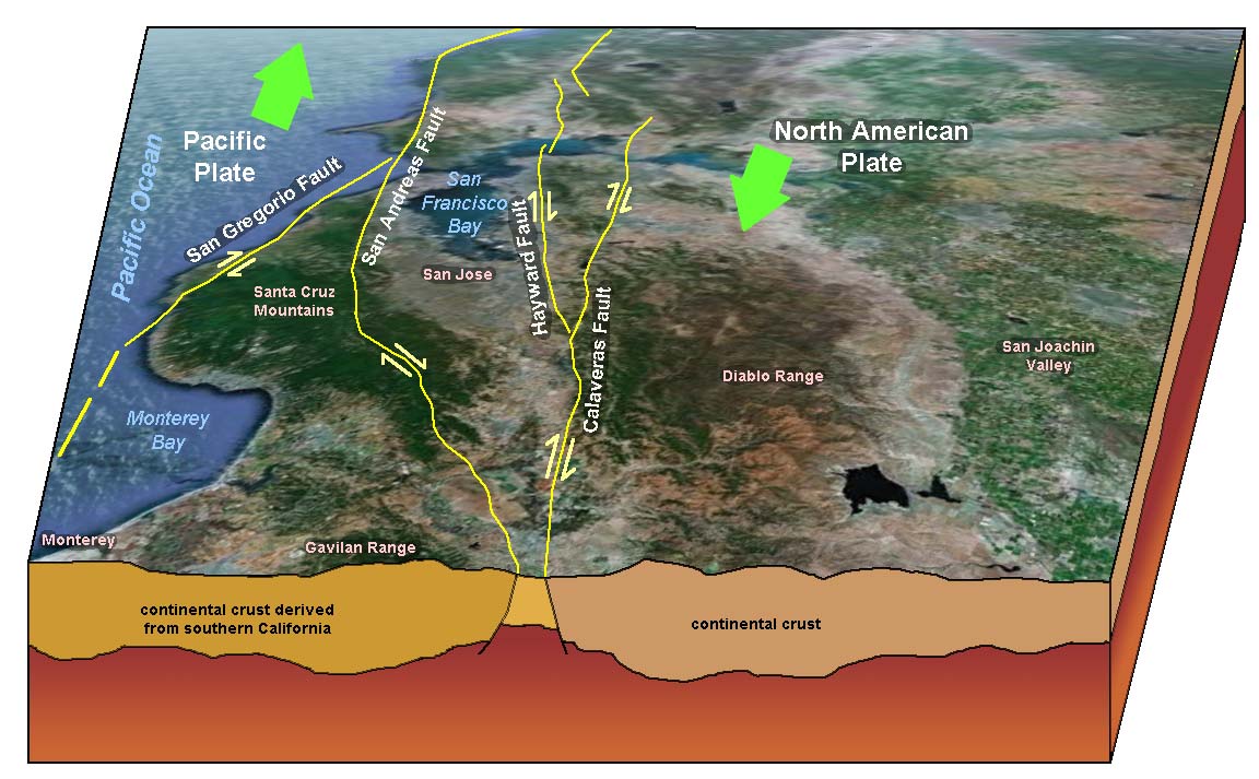
TerranesIn geology, the word terrane is used to describe a fragment of crustal material that formed on, or has split away from, one part of a tectonic plate and then accreted onto crust in another location or onto a different plate. Terranes are large crustal blocks (slivers of crust the size of mountains) that are bounded on the sides by great faults, usually strike-slip faults. Throughout regions like the Coast Ranges of California there are numerous terranes, and the rocks of one terrane are usually very different in composition to the terrane next to it. In the Coast Ranges, terranes are stacked up like books on a shelf, bounded by earthquake-prone faults.Figure 5-57 illustrates terranes in the San Francisco Bay area. This cross section of the Santa Clara Valley (east-to-west near San Jose, California) shows several fault-bounded terranes. Each of the large crustal blocks formed in locations far south of the Bay Area, but have gradually moved north along the fault system that bifurcates through the region. Over time, California has formed (assembled) by the accretion of terranes (small crustal landmasses) carried in by plate-tectonic processes slowly over geologic time. Each of the terranes originally formed in different places under different conditions. |
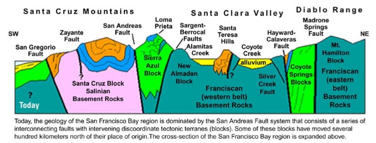 Fig. 5-57. Terranes in the greater San Francisco Bay Area, California. This generalized cross section runs east-to-west from the Diablo Range to the coast and offshore near Santa Cruz (roughly about 40 miles). As many as seven different terranes are sandwiched together as belts of rock between a series of great north-south trending faults including some of the most active earthquake faults: the San Andreas, Calaveras, and Hayward faults. Fig. 5-57. Terranes in the greater San Francisco Bay Area, California. This generalized cross section runs east-to-west from the Diablo Range to the coast and offshore near Santa Cruz (roughly about 40 miles). As many as seven different terranes are sandwiched together as belts of rock between a series of great north-south trending faults including some of the most active earthquake faults: the San Andreas, Calaveras, and Hayward faults. |
Ancient Parts of Continents: Cratons and ShieldsA craton is a part of a continent that is stable and forms the central mass of the continent. The craton region of North America includes the region between the Rocky Mountains (to the west) and the Appalachian Mountains (to the east) and include the Canadian Shield.A shield is a large area of exposed Precambrian-age crystalline igneous and high-grade metamorphic rocks that form tectonically stable areas. In all cases, the age of these rocks is greater than 570 million years and sometimes dates back 2 to over 4 billion years. For instance, the Canadian Shield is part of the North American craton region. Billions of years ago, the Canadian Shield formed from the accretion of numerous terranes and was likely host to massive mountain ranges. Once the region became isolated from the massive tectonic forces along the increasingly distant continental margins, the landscape slowly eroded down to sea level. Over time, shallow inland seas have flooded over and retreated from North America's craton/shield region in the past billion years. |
|
| Continental shields contain the oldest rocks preserved in the cores of continental landmasses. These regions formed by processes associated with continental accretion billions of years ago, long before the continents of the modern world existed. These ancient shields are part of the stable parts of continents (cratons) and in many places are partially covered by younger sedimentary rocks (such as in the Great Plains and Midwestern Low Plateau regions of North America). Figure 5-58 is a generalized geologic map of the world. Areas in orange and pink on the map are regions that would be considered shield or craton regions. |
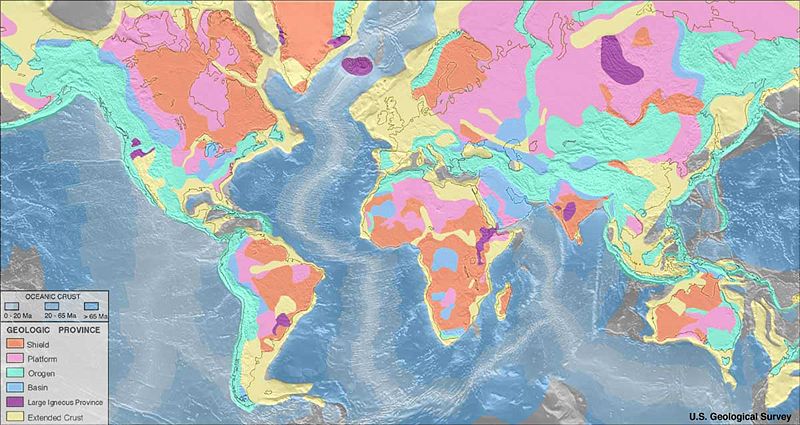 Fig. 5-58. Continental shields and cratons of the world |
Formation and Breakup of PangaeaThrough geologic time new continental crust forms and accumulates (accretes) along the margins of continents. The floating continental crust eventually crashes into other land masses, and these terranes may assemble into larger continental crustal plates. For instance, the formation of the ancient supercontinent Pangaea assembled through continental accretion. Pangaea later gradually split apart by continental rifting forming the world's continental landmasses that exist today. The geologic story of the formation and breakup of Pangaea are preserved in the rock record all along the Atlantic Margin of North America, Europe, and Africa.Figure 5-59 illustrates the formation of Pangaea during Paleozoic time (from the perspective of small continental landmasses being crushed together as an ancient basin closed between North America and Europe and Africa, forming the ancient supercontinent (see cross sections A to E in the order that events occurred). Figure 5-60 show how Pangaea then slowly broke apart, forming continental rift valley, of which one continued to develop and eventually continued to spread to form the Atlantic Ocean Basin (sections A to D in the order that events occurred). |
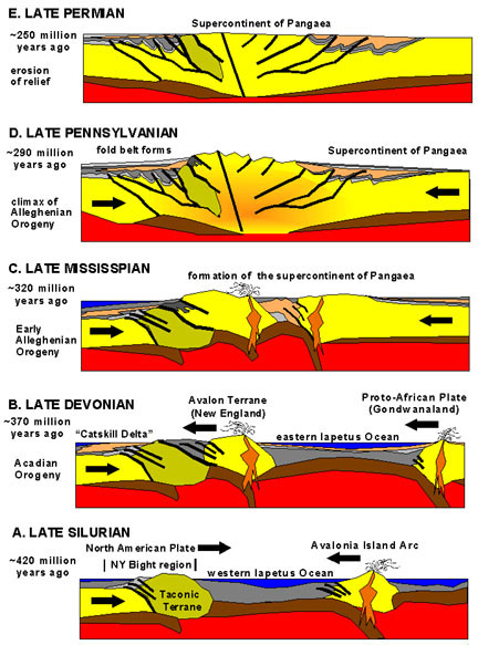 Fig. 5-59. Formation of Pangaea by closing of the proto-Atlantic (the ancient Iapetus Ocean) about 300 million years ago. |
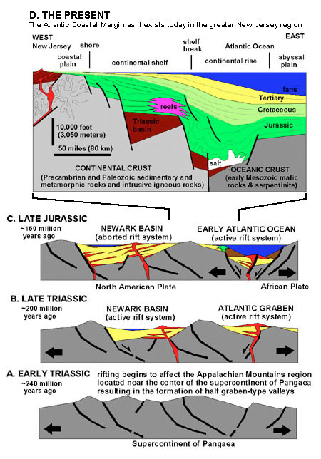 Fig. 5-60. Breakup of Pangaea and formation of the Atlantic Ocean about 200 million years ago. |
| Plate Tectonics Theory incorporates ideas presented earlier by Wegener’s Continental Drift Theory that all the previously existing continental landmasses began to assemble into the single supercontinent, Pangaea, starting around 300 million years ago. Oceans and sea basins that existed between some of continents disappeared because of plate convergence, crushing ancient seaway basin deposits up into mountain ranges (including the Alps, Appalachian and Atlas Mountain belts in southern Europe, eastern North America, and northern Africa, respectively). For instance, an ancient ocean called the Iapetus Sea existed between North America and Africa before Pangaea assembled (Figure 5-59, A and B). When Pangaea completely assembled in the Late Paleozoic Era, it was surrounded by one global ocean (named Panthalassa). However, staring about 200 million years ago (in the Triassic Period) Pangaea began to split apart, first separating into two sub-supercontinents, Gondwanaland and Laurasia (Figure 5-61). Gondwanaland (or Gondwanaland) was a landmass mostly in the Southern Hemisphere tat eventually split apart into South America, Africa, Antarctica, Australia, and India. Laurasia was the landmass in the Northern Hemisphere that eventually split into North America and Europe and Asia. As Gondwanaland and Laurasia separated, the ancient Tethys Seaway developed between the two sub-supercontinents and ran roughly east-to-west along the equator region (see Figure 5-61). The Tethys Seaway existed before the opening of the Atlantic and Indian Ocean basins. Note that organic-rich sediments deposited in the ancient Tethys Seaway basin are the origin of the massive petroleum deposits in the Middle East and surrounding regions. |
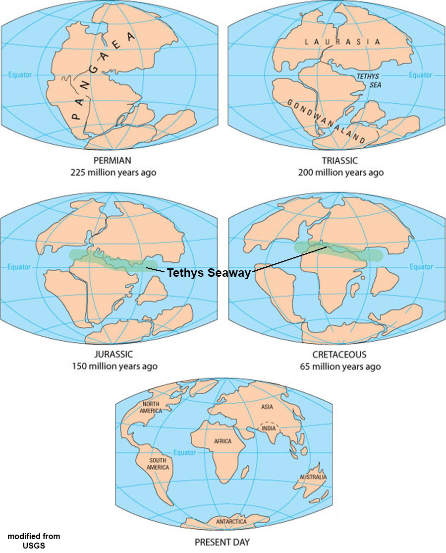 Fig. 5-61. Location of Laurasia and Gondwanaland, and the ancient Tethys Seaway. |
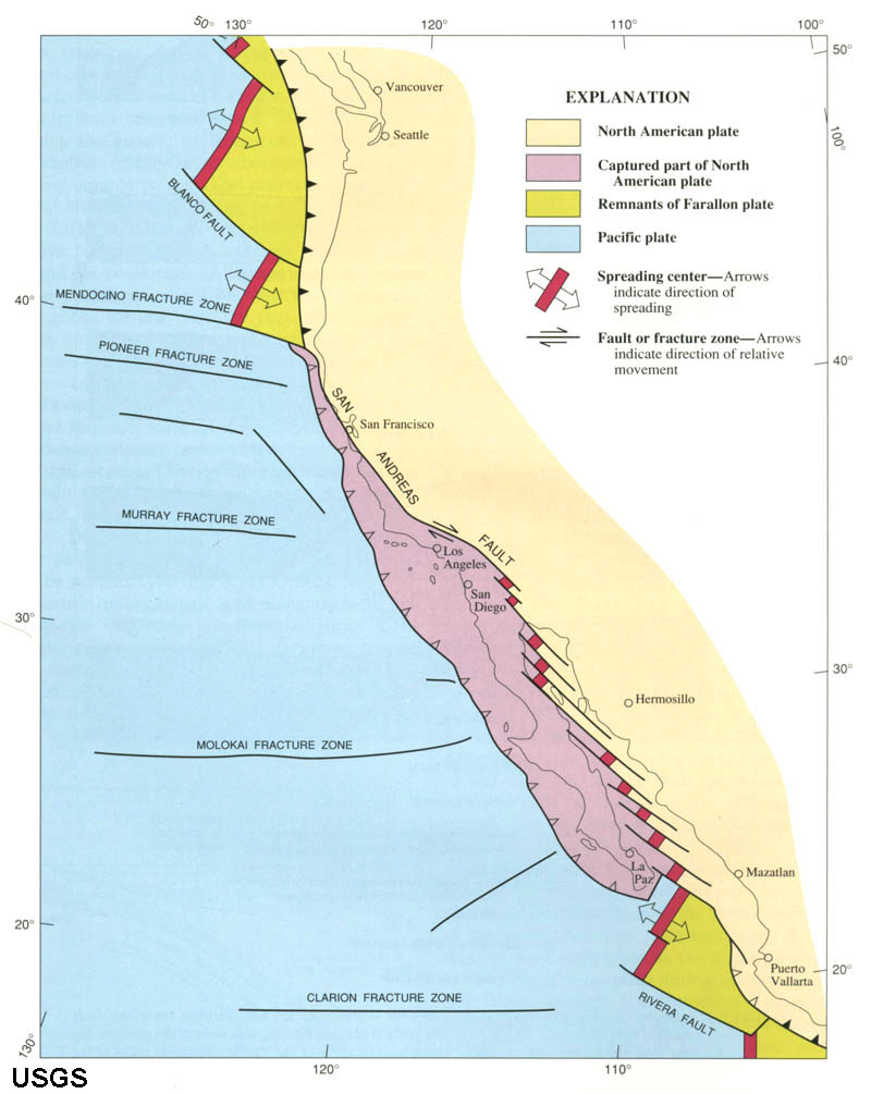
California Geology and Plate Tectonics HistoryCalifornia has been one of most studied geologic region of the world, and for good reasons: earthquakes faults (Figures 5-62 to 5-64)!Through its history, California has transitioned from a passive continental margin (before the breakup of Pangaea) to an active margin with the transition to subduction zone activity and the formation of the Cordilleran volcanic chain (during the Mesozoic Era). The Cordilleran Ranges is name for the volcanic arc that formed the Sierra Nevada Range and the Peninsular Ranges extending south in to Baja California). Subduction ended when the ancient Farollon Plate was overrun as North America moved westward, overriding the northern end of the spreading center in the Eastern Pacific basin (Figure 5-65). This lead to the formation to the modern transform plate boundary associated with the San Andreas Fault (part of the greater California fault system) and the opening of the Gulf of California. |
|||
|
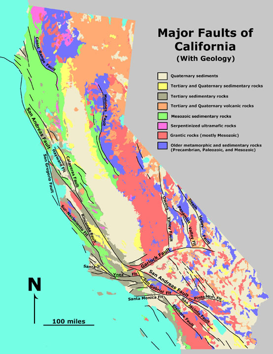
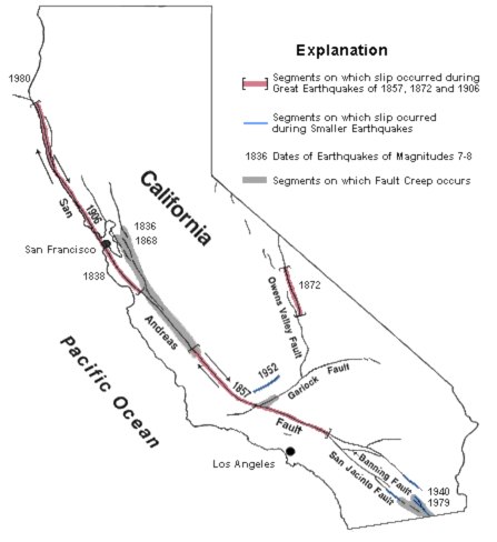
Plate Tectonic History of CaliforniaLibrary shelves are filled with publications about the geology and geologic history of California. Below is a brief (generalized) summary.California gradually formed (or assembled) over a billion years though processes involving subduction (forming volcanic island arcs) and by accretion (attachment of small land masses carried in from other parts of the Pacific Ocean basin). Before the opening of the Atlantic Ocean Basin, California was sometimes a passive margin (not experiencing massive tectonism and mountain building similar to what is happening today). Below is a generalized summary of the geologic history of California. No rocks older than ~1 billion years exist in CA - all more ancient materials in the CA region were subducted or moved elsewhere... ~1 billion to ~250 million: CA was a mostly a passive margin or was accumulating as sediments on an actively migrating seafloor. Periods of mountain building and other plate-tectonic-related activity moved small land masses along the West Coast continental margin. The North America continent gradually moved westward and northward over time. ~250 to ~30 million: subduction and island-arc volcanism dominated the CA coast. An ocean trench existed along where the coast exists today, and a subduction-zone-related igneous activity created the great volcanic arc formed the core of the Sierra Nevada ~30 years ago to present: Formation of the San Andreas Fault caused by North America Plate overriding the ancient Farallon Plate. Remnants of the Farallon Plate exist as the Juan de Fuca Plate (offshore Oregon & Washington) and the Cocos Plate (off central America (Figure 5-65). As the San Andreas Fault System developed, transform faulting replaced subduction. Baja California split away from the Mexico. Uplift and erosion has exposed the core of the ancient volcanic arc now exposed throughout the Sierra Nevada and Peninsula Range (Baja and San Diego region). The region west of the San Andreas Fault (attached to the Pacific Plate) is slowly moving north relative to the crust east of the Fault (the North American Plate). Figures 5-66 to 5-68 show some supporting evidence of the long-distance transform faulting along the San Andreas Fault System over time. |
 Fig. 5-65. Formation of the San Andreas Fault as the Farollon Plate was subducted over the past 30 million years. |
||||
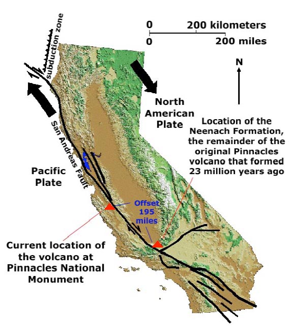
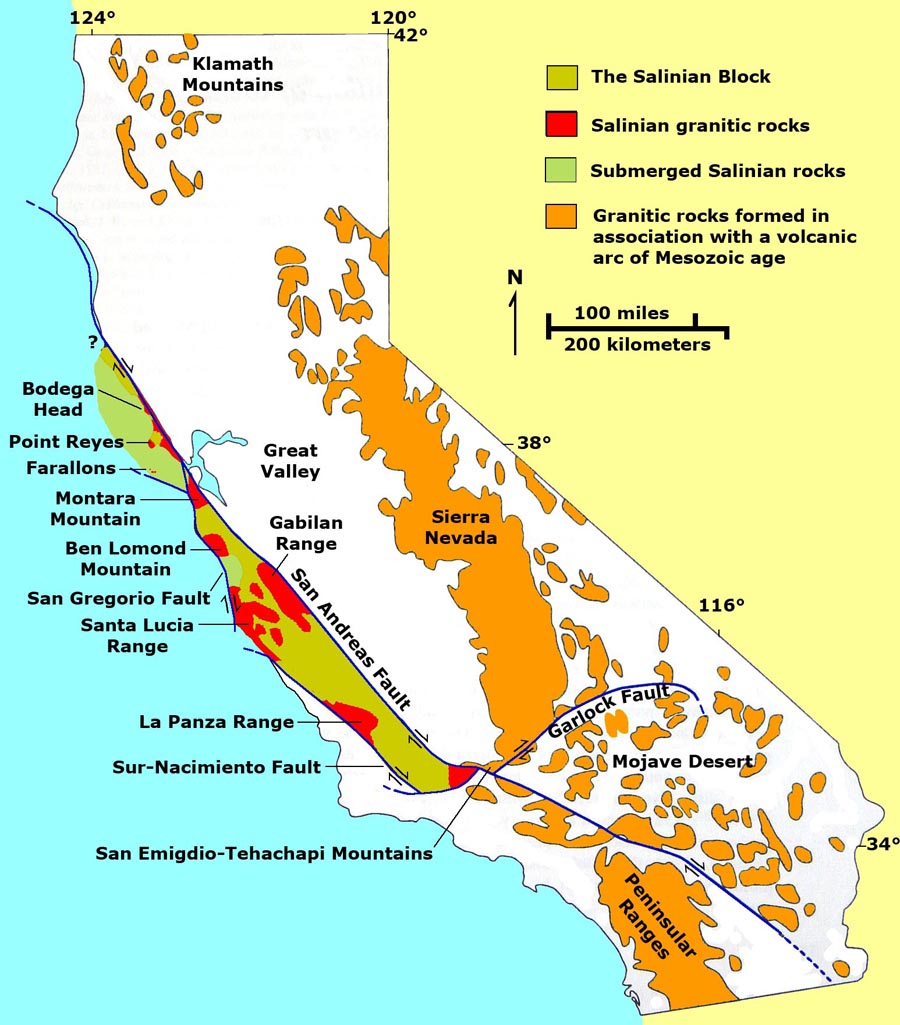
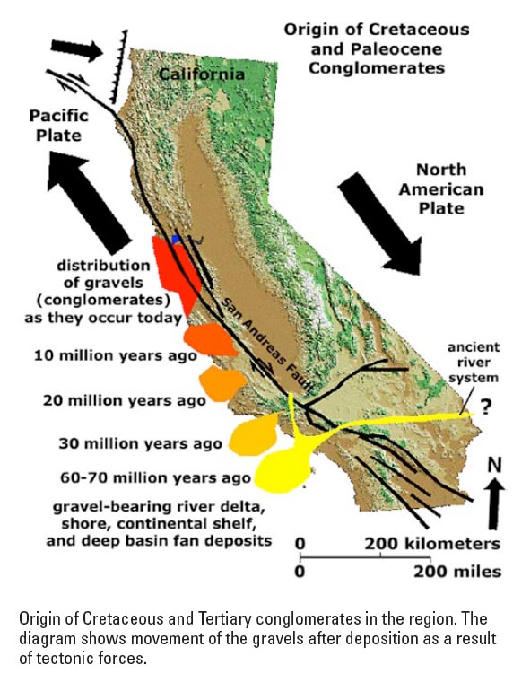
Supporting evidence of long-distance movement along the San Andreas Fault System.
|
|||||
Recommended reading!Learn more about Plate Tectonics Theory at these online resources prepared by the Smithsonian Institution and U.S. Geological Survey:This Dynamic Earth (The Story of Plate Tectonics) - this on-line booklet is used for teaching plate tectonics at schools and universities around the world. It has a companion map: This Dynamic Planet (World Map of Volcanoes, Earthquakes, Impact Craters, and Plate Tectonics (see Figure 5-66). Crustal age of the Seafloor Map: National Oceanic and Atmospheric Administration, National Geophysical Data Center [large image] |
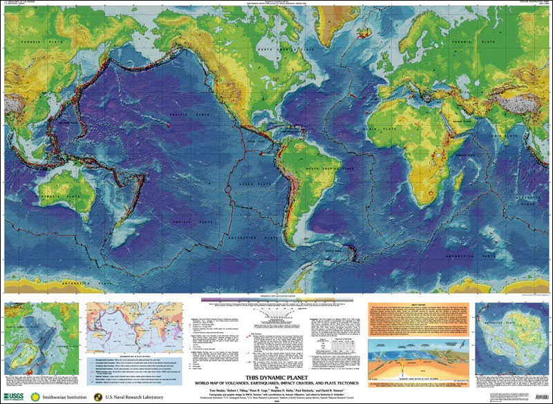 Fig. 5-70. Plate Tectonic Features Map from This Dynamic Planet. |
12/28/2018