
Volcanoes of the Western United States
Thiswebsite is an introduction to volcanoes and volcanic hazards, and includes a tour of selected modern and ancient volcanoes and associated landforms in the western United States (including Alaska and Hawaii). Geologic surveys indicate there are as many as 169 “active volcanoes” in the United States (the most of any nation. “Active" means they have erupted with the past 10,000 years. Most of these active volcanoes have the appearance of quietly rising in the distance, but a closer look can reveal incredibly cataclysmic activity in the prehistoric past. Many American volcanoes and volcanic area are preserved in national parks and “safely” isolated on public lands (mostly wilderness). Some volcanic areas have designated moderate- to high-risk factors for potential volcanic eruptions, landslides, and seismic activity.
Communities in the western US have experienced nearby volcanic eruptions for centuries. Yellowstone (a supervolcano) became the world's first "national park." However, it wasn't until the eruption of California's Mount Lassen in 1915 that serious investigations into volcanic activity got started. "Geoscience communities" have been investigating the volcanoes for well over the past century with many thousands of articles, books, and technical reports published over the years (select resources are included below). The discussion focuses on landscape and geologic features associated with volcanoes, both modern and ancient (extinct). This website is purely for educational purposes only. The graphics presented below correspond to talks presented to gem and mineral societies, community organizations, and adult education programs in the San Diego Region.
Return to Field Trips main page. |
Click on images for a larger view. |
| Fig. 1. This introductory slide shows two entirely different kinds of volcanoes: lava "gently" erupting from a cinder cone on Kilauea volcano on the Big Island of Hawaii, and the massive explosive eruption of Mt. Redoubt volcano in Alaska. The behavior of a volcano is conditional on a variety of factors including the temperature and composition of the magma feeding a volcano, which is related to the geologic setting where the volcano has formed, over time. | 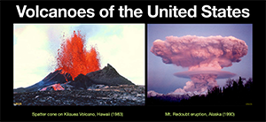
|
| Fig. 2. This map modified from the Smithsonian Institution, Global Volcanism Program, show the location of "active volcanoes" -- active meaning "volcanoes that have erupted in the past 10,000 years (Holocene to Present). Most volcanoes occur around the margin of the Pacific Ocean's "Ring of Fire" with other areas such as the Afar Triangle area of Africa, or along the mid-ocean ridges around the world. It is important to point out that although North America (particularly the United States and it territories) "owns" the most active volcano, but fortunately most of these are in remote locations (with some exceptions) compared to other Asian nations. | 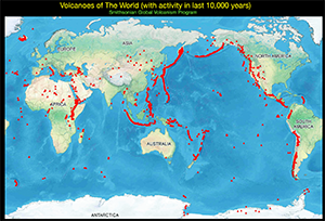
|
| Fig. 3. There are many kinds of "volcanic hazards" that are related to the different kinds of volcanoes. The kinds of volcanoes found along the "Ring of Fire" are perhaps the most dangers, capable of producing explosive blast, pyroclastic flow and lahars, and can cause tsunamis, release clouds of toxic gases and produce ash falls that can blanket large regions. Huge eruptions can impact climate and weather for years after an eruption. Eruptions can have dramatic impacts of civilization. A particularly interesting book named "Krakatoa, The Day the World Exploded" by Simon Winchester describes the impact of the 1883 volcanic eruption, and how it ultimately changed the world politics of Southeast Asia. | 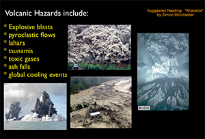
|
| Fig. 4. These figure show features associated with volcanoes and volcanic hazards. The diagram on the right shows "why volcanoes erupt" caused by the hot gases (mostly water) trapped some kinds of magma explosively expands with a release of pressure. For instance, a cubic meter of 900 degree Celcius rhyolite magma containing 5% water will expand to 670 cubic meters in a eruption. This produces the magnificent blasts and fountains of lava associated with some volcanic eruptions. | 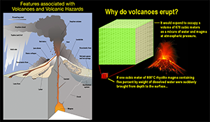
|
| Fig. 5. This diagram comparis the volcanic gas composition from different volcanoes based on plate-tectinic settings. Three are illustrated here including Kilauea (a Hawaiian hotspot volcano), Erta Ale (a divergent plate boundary volcano in the Afar Triangle, Africa), and Momotombo volcano (a convergent plate boundary volcano in Nicaragua). Note the differences in the temperature of the magma as well as the compositional difference of the gases released by the volcanoes. Kilauea's magma is both very hot, and depleted in water content compared to the divegent and convergent plate boundary volcanoes. It is the water content (ultimatedly from trapped seawater) that make these eruptions so explosive. | 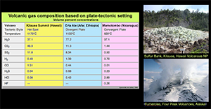
|
| Fig. 6. These two diagrams show where most volcanoes occur. On the left is a divergent plate boundary along mid ocean ridges (most of which we cannot see and are unmapped). Here, ocean water can migrate into the newly formed crust to be incorporated into the magma. On the right, a is convergent plate boundary, where subduction along plate boundaries are moving water-saturated rocks downward into the zone of melting deep with the earth. Convergent plate boundary volcanoes have the highest water content and tend to produce the most explosive eruptions. | 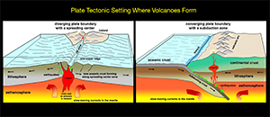
|
| Fig. 7. Hotspot volcanoes are the 3rd type of volcanoes, and the United States owns two (possibly more) of them. The Hawaiian volcanes are the youngest of the Emperor volcanic island chain in the Pacific Basin. The trail of volcanoes (with ages show) show how the Pacific plate has been migrating of a hotspot where magma is rising deep from the mantle. The origin of hotspots is still debated (could they be created by deep penetrating asteroid impacts?). The Yellowstone Hotspot is another migrating feature as the North American Plate moves westward over a stationary mantle source (more on Yellowstone later). | 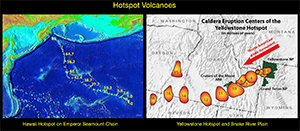
|
| Fig. 8. This is a general diagram that shows the different kinds of landforms associated with modern and ancient volcanoes. "Active" volcanoes retain many of their freshly-formed features (cones, flows, etc.). Whereas, extinct volcanoes tend to quickly erode away (in "geologic terms" quickly), leaving behind remnant of their former selves, particularly the harder rock associated with their stocks, dikes, sills, and palisades. Over millions of years, an entire volcanic chain will erode away, leaving the deeply-formed batholitic chambers with magma once accumuated deep in the subsurfaces. | 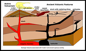
|
| Fig. 9. This figure show a map of 4 large batholiths that formed along the western margin of North America in Mesozoic time (mostly in the Late Cretaceous Period, about 100 to 70 million years ago; shown in red). This includes the Okanagan, Idaho, Sierra Nevada, and Peninsular Ranges batholiths (north to south respectively). The ancient volcanic arcs associated with these batholiths have long since eroded away, leaving the granitic core of the batholiths locally exposed in mountain ranges at the surface. Also note on the map the extensive orange regions on the map. These are regions where volcanic rock of Tertiary and younger age (>60 million years) are exposed, mostly in the form of extensive lava flows. | 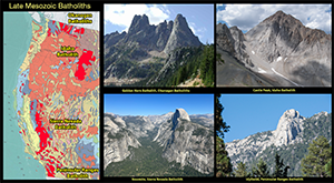
|
| Fig. 10. This map show the location of major volcanic regions that formed in Tertiary time (after the Western Cordilleran Ranges volcanoes shut down along the coast, and volcanic activity migrated eastward into the Great Basin and Rocky Mountains region as the North American plate moved westward. Large volcanic eruptions occurred throughout Nevada and Utah, and throughout the region where Laramide Mountain ranges were forming, this includes the Absaroka Mountains (Wyoming-Montania), the San Juan Mountains of Colorado, and the Mogollon-Datil volcanic region of Arizona-New Mexico, and other places across the Rocky Mountain region (examples include Ship Rock (AZ), Devils Tower (WY), and Chisos Mountains (TX). These are eroded remnants of what where once larger volcanoes. | 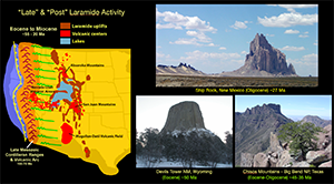
|
| Fig. 11. Massive volcanic eruptions occurred in Tertiary time that have no comparison to anything that has occurred in the last 10,000 years. Huge eruptions in Nevada in Miocene time blanketed much of the North American continent with layers of volcanic ash. These eruptions demolished entire ecosystem. In locations as far away as the Badlands of South Dakota and High Plains of Nebraska there are exquisite "bone beds" where hurds of prehistoric animals were smothered in the vicinity of their waterholes. Bone beds are preserved in Agate Fossil Beds National Monument and Ashfall Fossil Beds State Historic Park in Nebraska. | 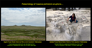
|
| Fig. 12. A brief look at how igneous rocks form is important to understanding volcanoes. Every introductory geology course looks at "Bowen's Reaction Series" which explains how the composition of igneous rock changes as a magma body cools. On the left are the common igneous minerals ranging from "high temperature minerals" (like olivene) below, and low temperature mineral (like quartz) above. As a magma body migrates upward, it gradually cools, allowing the high temperature mineral to crystallize first. As these "mafic" minerals settle out, it gradully changes the composition of the magma to a more "felsic" composition with low temperature minerals, like quartz (and ice), being the last minerals to form. | 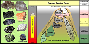
|
| Fig. 13. How quickly or slowly molten material cools into rock determines what size crystals may develop. Slow cooling results in larger, differentiated crystals, where rapid cooling prevents larger crystals from forming (they are microscopic crystals). Shown here is the intrusive igneous rock, granite with large interlocking crystals of quartz, feldspar and mica. On the right is a chunk of the extrusive igneous rock, rhyolite. In mineral and chemical composition they are identical, only the rhyolite formed as the lava cooled quickly. Volcanoes are associated with extrusive igneous rocks that form at or near the surface. | 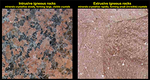
|
| Fig. 14. This is a picture of an outcrop of igneous rock in the cactus garden in the San Diego Safari Park. It displays 3 types of rock: dark gabbro (mafic), gray tonalite (intermediate), and white "granite" filling fractures (felsic). This outcrop illustrates the general order in which the magma body formed, starting with the cooling of the high temperature minerals (forming the dark gabbro). Chunks of this were carried upward and were incoporated into the magma as the intermediate temperature mineral from (forming the tonalite), an then in the final stages as the magma chamber cooled and contracted, fractures formed where the last of the low-temperature minerals were able to crystallize as the last of the gases were expelled. | 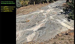
|
| Fig. 15. On a simpler scale, volcanic rocks are described by their color (leave the more detailed classification to an igneous petrologist!). Light-colored volcanic rock tend to be of felsic composition, and called "rhyolite." Dark or black volcanic rock of mafic (or ultramafic) composition is called "basalt." In the intermediate range (between light and dark) is andesite. Basalt is associated with high-temperature lavas, such as on Hawaii. Whereas the rhyolite and andesite lavas are associated with the lower-temperature eruptions of volcanoes such as the Cascades and elsewhere. | 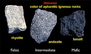
|
| Fig. 16. In quick review, here is a look at different igneous rocks in landscapes intrusive and extrusive origin (having generally the same mineral composition. Here are felsic rocks: intrusive - granite exposed in the Granite Mountains (Mojave National Preserve), and extrusive - rhyolite exposed in the Grand Canyon of the Yellowstone (Yellowstone National Park). Note the similarity of the colors. | 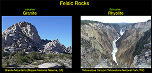
|
| Fig. 17. This shows the rocks of more intermediate composition. On the left is the gray intrusive granodiorite-diorite of the Sierra Nevada batholith (in Yosemite National Park). On the right is the gray extrusive dacite-andesite exposed in the lava dome volcanoes of Lassen National Park. | 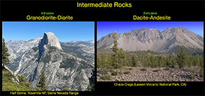
|
| Fig. 18. Next are examples of rocks of mafic composition. On the left is the dark intrusive gabbro exposed in Black Canyon of the Gunnison National Park in Colorado. On the right is the example of dark extrusive basalt exposed on the cinder cone and lava flows of Amboy Crater in California. | 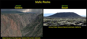
|
| Fig. 19. Finally, are rocks of ultramafic composition. The crystalline intrusive igneous version of these rocks are fairly rare on the surface. Chuncks of rock like pyroxenite and peridotite occur inbedded in lava that has migrated to the surface during the late stages of eruptions. In contrast, nearly all lavas on the Big Island volcanoes are basalt of ultramafic composition. Particularly famous is the rare Green Sand Beach, composed of tiny green olivine (peridote) crystals at South Point on the Big Island. As local geologist friends like to describe it as "It's totally ultramafic, Dude!" | 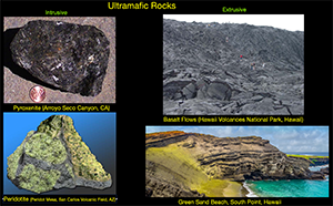
|
| Fig. 20. This diagram illustrates the general types of volcanoes. Hot (basaltic) lavas can flow for long distances, resulting in lava fields from fissure eruptions or the gentle buildup of shield volcanoes (such as on Hawaii). Cooler magmas (of intermediate to felsic composition) produce the more complex volcanoes including the dome, ash-cinder, and composite volcanoes where escaping gas eruptions produce cinder and ash that accumulate in cone fashion. Large (destructive!) eruptions may partially empty a magma chamber below a volcano, resulting in the collapse and formation of a large crater (or caldera). | 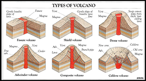
|
| Fig. 21. Moving on, let's look at some volcanoes and volcanic features, starting with Hawaii. The Big Island is composed of 5 large volcanos, 4 of which are in still in the "active" catagory. This map show the location of "historic" lava flows in red (historic since about 1800). Mauna Loa is the largest volcano on the planet and has been recently active. Kilauea is on the southeastern flank of Mauna Loa. Halualai is on the Kona side, and Mauna Kea is on the north side. Kohala is considered somewhere between "dormant" and "extinct" (showing no signs of activity). A sixth and newest volcano of in migrating hotspot chain is Lo'ihi, located offshore of Kilauea and still 3,000 feet below the ocean surface. | 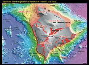
|
| Fig. 22. On the Big Island (and on volcanoes elsewhere) there are two common types of lava rock. On the left is pa'hoe'hoe - the Hawaiian name for lava with a ropey appearance formed as fluid lava quickly cools on the surface. On the right is the blocky lava called "a'a" - it forms as the crusty surface of a lava flow breaks up as it is carried down the slope. It legendary name come from how hard it is to walk on with bare feet... | 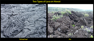
|
| Fig. 23. This picture taken looking south from along the Saddle Road shows the broad shield shape of Mauna Loa volcano with its basaltic lava flows. | 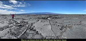
|
| Fig. 24. This view picture taken looking north from along the Saddle Road shows the broad shield-composite shape of Mauna Kea volcano with its slightly steeper slopes from a mix of lava flows and cinder eruptions. | 
|
| Fig. 25. Both Mauna Loa and Kilauea have gravity-induced fissures (fault zones) that run along the gentle arm-like ridges that extend away from the main volcanic crater area. These fracture zones occasionally become vents for fissure eruptions that produce lava flow that spread across the landscape. | 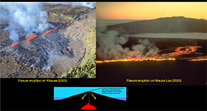
|
| Fig. 26. This figure shows the large Hale'mau'mau crater on the summit area of Kilauea. This crater is about a half mile across, and a lava lake rises and falls within the crater during eruptions. The picture below shows lava fountains (some as high as 300 feet) erupting in December, 2024 in the crater. The figure on the right show lava flowing into the sea, resulting in the massive plume of steam and volcanic pollution called vog. Click here to see recent Kilauea eruption pictures taken on January 17, 2025. | 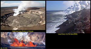
|
| Fig. 27. This figure show the fountaining vent eruption of Pu'u'o'o, a small volcano that formed along the rift zone on the flank of Kilauea. This eruption began in 1983 and flowed continuously until the eruption ended in 2018 -- the longest continuous eruption in U.S. history. | 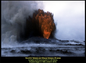
|
| Fig. 28. This view shows the ribbon-like lava flow pouring of out of the vent crater on Pu'u'o'o. In it's 35 year eruption cycle, it built up a small shield cone on the flank of the much larger Kilauea volcano. Kilauea began forming on the seabed about 280,000 years ago. It's surface now covers an area almost the size the Hawaiian island of Oahu. | 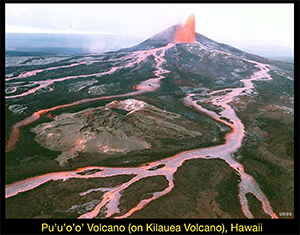
|
| Fig. 29. This is a "tourist view" of one of the lava flows on Kilauea (I took in the 1990s). Visiting the active lava flows is considered relatively "safe" in Hawaii Volcanoes National Park. A ranger may or may not be present where the flows are moving. We watched a ranger walk directly on the red-hot lava (with thick boots on) and he barely made a dent in the lava. This view (with "Pelee's eyes) show where lava broke out of a lava tube and slowly pooled, forming pa'hoe'hoe. The lava is so extremely hot that you do not want to get too close to it. Note, you cannot get close to where the vent is erupting. | 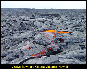
|
| Fig. 30. This is a view of the Thurston Lava Tube (in the national park). There are an abundance of lava tube on Hawaii's volcanoes (most are kept private or inaccessible). Lava tubes form as conduits of lava below the surface within larger lava flow, and form as lava eventually drains out at the lower end of the passage. (Thurston -- a in Gilligan's Island TV show.) | 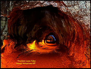
|
| Fig. 31. This view is looking east along the Kona Coast toward Halualai Volcano, overlooking the Kailua-Kona area, dry side of the Big Island. Halualai, another massive shield volcano, last erupted in 1801. Massive flows from that eruption period can be seen on the west side of town near the airport. | 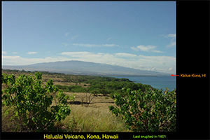
|
| Fig. 32. This view is looking west along the Kona Coast toward the island of Maui, and it's massive volcano, Haleakala. This massive shield-composite volcano rises above 10,000 feet and last erupted about 400 to 600 years ago. Much of it is preserved as Haleakala National Park. | 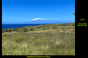
|
| Fig. 33. This view is looking down from the summit area of Haleakala volcano to the broad cinder-covered crater-valley that extends down to the sea. On the right is an example of of unusual and endangered Silver Sword agave that is endemic to the barren crater area. | 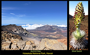
|
| Fig. 34. Alaska is host to the most active volcanoes, mostly in the Aleutian Island Chain extending southwest from the Anchorage area. Some of these volcanoes are among the most active, and historically have produced massive eruptions. Some of which have had major impact on global aviation in recent times. This map shows some of the volcanoes are set aside in Alaska national parks, monuments, and preserves. | 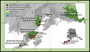
|
| Fig. 35. Mt. Katmai is the largest volcano in Alaska, and its 1912 eruption was the largest volcanic eruption of the 20th century. This view shows the massive lake-filled crater on top of the volcano, and Mt. Gribbs in the distance. The massive 1912 eruption blanketed the surrounding region with pyroclastic flows, creating the famous "Valley of Smokes" nearby. The flows have basically cooled enough in the past century to quit smoking (until the next eruption). All of the Aleutian volcanoes are composite cones that tend to produce highly explosive eruptions when they occur. | 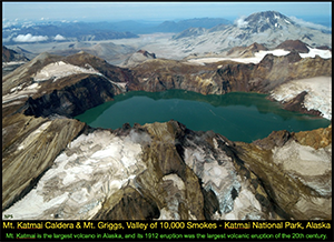
|
| Fig. 36. This view shows the nearly symmetric cone and small summit crater of Shishaldin volcano and the nearby Isanotski volcano on Unimak Island in the Aleutian volcanic arc, Alaska. | 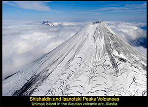
|
| Fig. 37. Mount Wrangell is a lone, massive shield-composite volcano (14,063' elevation) in the very remote wilderness portion of Alaska, and is with the Wrangell-Elias National Park & Preserve. The volcano last erupted in 1902. | 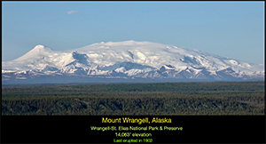
|
| Fig. 38. This figure show the active volcanoes within the Cascade Range that extends from northern California trough Oregon, Washington into southern British Columbia. This volcanic arc consists of 13 large active volcanoes, and numerous old smaller volcanoes ("dormant or extinct"). These are all composite volcanoes that have cyclic history of eruption stages, including build up cones, then partly collapsing (forming craters or calderas) before resurrecting into a new version of itself. This diagram show the eruption history of these active volcanoes for the past 400 years, with Mount St. Helens and Mount Shasta being among the most active. | 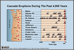
|
| Fig. 39. This view shows Mount Rainier (overlooking Seattle). Mount Rainiers is potentially the most dangerous volcano because of its proximity to large population centers (Tacoma, Olympia, Seattle, and numerous other small cities and towns). Some of these town have been allowed to be constructed on the lahar deposits from previous eruptions. Although, now within Mount Rainier National Park, it is considered a dangerous volcano with its massive glaciers being a source of water for massive lahars created by an eruption. | 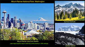
|
| Fig. 40. Mount St. Helens is perhaps the most famous Cascades volcano because of its massive eruption and collapse on May 18, 1980. The eruption cause a portion of the volcano to collapse as a massive landslide and pyroclastic flow that spread down the Toutle River valley and surround region. Since then, a series of plugs have been building up in the crater, producing occasional eruptions and pyroclastic flows. It is now a national park. | 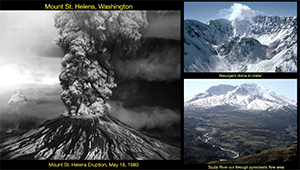
|
| Fig. 42. This view shows other Cascades active volcanoes (yet currently dormant in their activity), including Glacier Peak, Mount Baker, and Mount Adams (in Washington), and Mount Hood, Mount Jefferson, and the Three Sisters (in Oregon). | 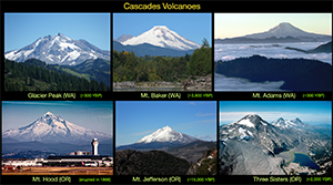
|
| Fig. 42. Mount Mazama is the massive volcano associated with Crater Lake National Park. The caldera eruption occur ~7,700 years ago. Wizard Island, within the caldera, last erupted 4,800 years ago. Crater Lake (1,943 feet deep) is the “deepest (and cleanest) lake in US.” | 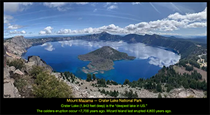
|
| Fig. 43. Perhaps the greatest volcanic story in the American West should be about the vast basalt fissure eruptions that flooded and formed what is now the Columbia and Oregon Plateaus, and the Snake River Plain (connecting a series of massive volcanic areas to the Yellowstone Hotspot). When these massive fissure eruptions started occurring in Miocene time, basaltic flows filled valley and spilled into adjacent valley, covering 10,000s of square miles in each subsequent eruption cycle. Stacked series of flows can be seen along the Columbia River Gorge (between Washington and Oregon). These two view show series of flows in the Sun River Lakes area of Washington and at John Day Fossil beds National Monument in Oregon. | 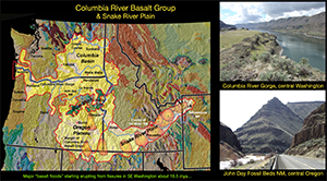
|
| Fig. 44. This view shows the entrance to a lava tube at Craters of the Moon National Monument (a "volcanic park" in central Idaho. Basaltic lava last erupted here 2,100 years ago. | 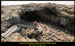
|
| Fig. 45. The Yellowstone Volcano is the largest in the United States. It's massive caldera is nearly 70 miles across" was discovered by USGS geologist, Bob Christiansen in the 1960s, and later observed by NASA astronauts. Although not consided active" based on its history, the last eruption being 70,000 years ago. However, earthquake activity, geothermal activity, and shift landscapes suggest that "activity" associated with molten material at depth is occurring. Three massive caldera-forming eruptions of occurred in the geologic past: 2,100,000 Ma, 1.3 Ma, and 670,000 years ago. The size and scope these massive eruptions in mind boggling to consider is such an eruption were to happen today. | 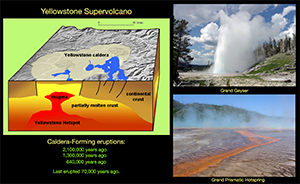
|
| Fig. 46. The map on the left shows the mapped extent of ashfall from the Yellowstone eruptions (compared with the Mount St. Helens eruption, and the Long Valley caldera eruption in California (discussed below). The diagram on the right comparatively illustrates the volume of the material ejected by the 3 Yellowstone caldera eruptions compared with major eruptions of historic times. | 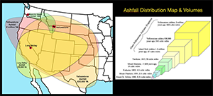
|
| Fig. 47. This map shows the designated "volcanic hazard" sites within California. Although there are numerous volcanoes in California, these are the ones of "significant interest for monitoring" in the state. This map was prepared by the USGS California Volcano Observatory group. The volcanic areas have hazard rankings of "high to very high" (red) and "moderate" (yellow), and which ones have erupted withing the past 3,000 years. | 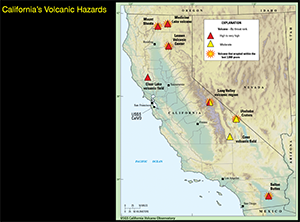
|
| Fig. 48. Mount Lassen is perhaps California's most famous volcano because of its series of explosive eruptions in 1915 and 1915. Mount Lassen (10,457’) is a “lava dome” volcano. It is the southernmost active volcano of the Cascades Range. The volcano is now within Mount Lassen National Park. | 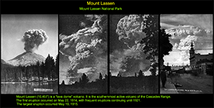
|
| Fig. 49. This view show the southern flank of Mount Shasta, the largest composite volcano in the Cascade Range (located in northern California). The volcano had minor eruptions between 1914 and 1917. | 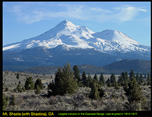
|
| Fig. 50. In terms of areal extent the Medicine Lake volcanic field is the largest active volcanic area in California, with an abundance of small cinder cone volcanoes and extensive fields of lava flows. Lava Beds National Monuments, with its numerous accessible lava tubes, is on the eastern margin of this volcanic field. | 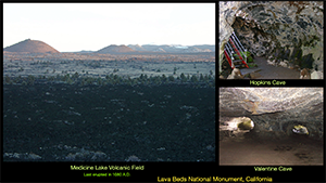
|
| Fig. 51. The significance how a major volcanic eruption might best be illustrated by the exposure of the Rocklin Ash, a foot-thick volcanic ash bed exposed in the seacliff at Fort Funston State Beach in San Francisco County, CA. The ashbed is associated with an eruption of Mount Tahama (now Mount Lassen) that occurred 600,000 years ago. Consider how a foot of ash and associated toxic volcanic fumes might impact the region today? | 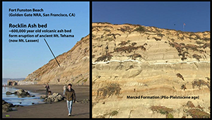
|
| Fig. 52. Possibly of greatest volcanic concern in California is a potential eruption associated with Mammoth Mountain and the Long Valley Caldera. The caldera is nearly 14 miles across and includes Mammoth Mountain on it's western side. The area has been experiencing numberous earthquakes in historic times, and warning of a possible eruption were noted in 1982, and again in 1989 fumerole active began venting mostly carbon dioxide, has killed large portions of the forest on the flank of Mammoth Mountain. A "very high threat" level was set by the USGS in 2018 for the caldera. Devils Postpile is a small national monument near Mammoth that is host of outcrops of columnar basalt features. | 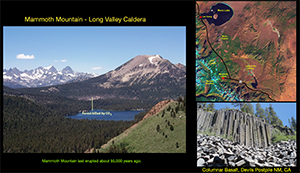
|
| Fig. 53. Mammoth Mountain last erupted about 55,000 years ago. To the north of the Long Valley Caldera and Mammoth Mountain (volcano) is a series of relatively young small volcanoes as part of the Mono Craters and Inyo Craters volcanic fields. Mono Craters last erupted about 600 years ago. The most recent volcanic activity in Inyo Craters occurred between 1720 and 1850. | 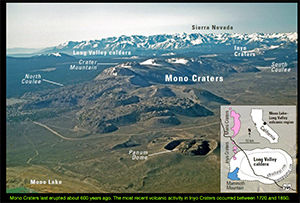
|
| Fig. 54. The eruption of the Long Valley Caldera about 764,000 years ago created the Bishop Tuff (named after the nearby town of Bishop, CA). The eruption released a volume of about 200 cubic kilometers outside the caldera, and about 345 cubic kilometers within the caldera. The image on the left is a quarry in the tuff near Bishop. The figure on the right is an unusual groundwater dewatering feature preserved in the Bishop Tuff on the shoreline of Crowley Lake, 15 miles south of Mammoth. | 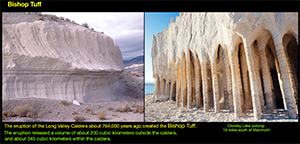
|
| Fig. 55. The eastern side of the Sierra Nevada range is the boarder with the Basin & Range Province where crustal extension (tectonics) is responsible for the occurrence of many young volcanic areas. The picture on the left shows the Big Pine volcanic field (near Bishop, CA). The picture on the right shows the Black Rock/Lunar Crater volcanic Field (near Tonapah, NV). | 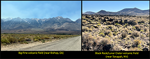
|
| Fig. 56. Farther south, Death Valley is host to some relatively recent volcanic active. This view show Ubehebe Crater in Death Valley National Park. It was formed from a “phreatomagmatic eruptive episode” about 2,100 years ago. | 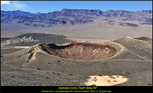
|
| Fig. 57. Split Cinder Cone is located in southern Death Valley National Park, CA. It erupted ~200,000 years ago along a strike-slip fault. Since then the western side of the volcano has moved nearly 2,000 feet to the north. | 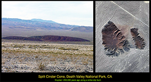
|
| Fig. 58. Cinder Cones National Natural Landmark is located in the Mojave National Preserve near Baker California. The volcanic field is host to some lava tubes (mostly inaccessible). The Hole-In-The-Wall location was a notorious bandit hangout in a landscape carved in a massive outcrop area of volcanic tuff. | 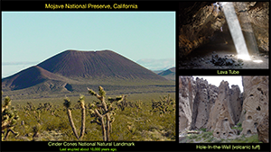
|
| Fig. 59. The closest area considered a "high volcanic threat" is at the southern end of the Salton Sea in an area called the Salton Buttes volcanic field. Figure on the lef show a map of the "geothermal field" being actively mined for geothermal energy and lithium-bearing brines. Within this vicinity is a field of mud volcanoes(also called gryphons). These are geothermal features that display flows similar to volcanoes on a smaller, low temperature scale. | 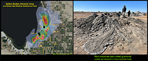
|
| Fig. 60. The Salton Buttes volcanic field consists of “5 volcanic domes formed in the past 10,000 years.” The youngest, Mullet Island dome (not shown here) last erupted about 1,800 years ago. The volcanic field is associated with the southern terminous of the San Andreas Fault. Although the rock of Obsidian Butte is black, is is actually of rhyolitic composition (as are Red Hill and Rock Hill volcanoes). Obsidian Butte was a probable origin of obsidian used to make arrowheads found throughout the region. | 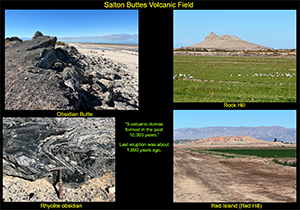
|
| Fig. 61. Although there are no active volcanoes in San Diego County, volcanic rocks and features can be seen in the Santa Margarita-Santa Rosa volcanic field area (Camp Pendelton); Sleeping Indian Hill - Morro Hills Volcanic Area (near Bosnall/Fallbrook); Calavera Hills volcano (in Carlsbad), and at Dike Rock (1/4 mile north of Scripps Pier near Blacks Beach. | 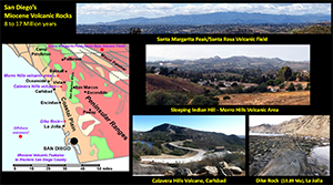
|
| Fig. 62. Arizona is host to numerous volcanoes and volcanic areas. The San Francisco volcanic field is consists of nearly 600 small to large volcanoes of a 5,000 square mile area in the vicinity of Flagstaff, Arizona. The youngest volcano, Sunset Crater, formed from an eruption about 1,000 years ago and impacted the ancient Puebloan communities at nearby Wupatki National Monument. | 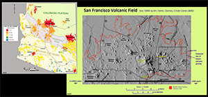
|
| Fig. 63. Humphreys Peak (San Francisco Mountain) on the northwest side of Flagstaff is the highest mountain in Arizona, 12,633 feet. Before its last massive eruption about 400,000 years ago, the volcano may have been as high as 16,000 feet, before part of it collapsed away in a Mount St. Helen- style eruption. Nearby Sunset Crater National Monument preserves the young volcanic features of the eruption 1,000 years ago that formed its cinder cone. | 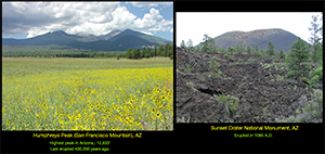
|
| Fig. 64. SP Crater is a classic cinder cone that leaked basaltic lava flows at its base. | 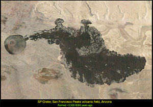
|
| Fig. 65. Perhaps the most dramatic volcanic features in Arizona are associated with the Unikaret volcanic field. In this area a series of lava flows that spilled over the ledge of the Grand Canyon and dammed the Colorado River, numerous times in the past. Mount Trumbull is an active volcano on the North Rim near the Toroweap Campground area. The most recent eruption in this area occurred about 900 years ago. The volcanic field shares the vicinity of the Hurricane Fault that extends northward into Utah. | 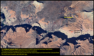
|
| Fig. 66. Now a quick look at New Mexico, another region host to numerous volcanic areas. In the northeast corner of New Mexico is the Raton-Clayton Volcanic Field - volcano last erupted ~55-60,000 years ago. Capulin Volcano National Monument is host to the "Easternmost volcano in the United States." | 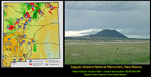
|
| Fig. 67. El Malpais National Monument is another volcano national park near the New Mexico/Arizona border. The park encompasses an extensive field of lava flows and is host to lava tubes (which are active bat caves). The view on the left shows Mount Taylor, a Pleistocene age volcano that is important to Navajo culture and religion. | 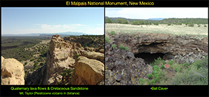
|
| Fig. 68. Possibly yet another supervolcano lurks in New Mexico in form of the massive volcano associated with the Valles Caldera in the Jemez volcanic field. The Valley Caldera is about 11 miles wide, and the volcano is about 50 miles across. The caldera last erupted about 74,000 years ago. The city of Los Alamos (of nuclear weapon history fame) is on the north side of the volcano. Note, if the area got more rain, it would probably be a lot like Yellowstone. The caldera area was used in the TV series, Longmere. | 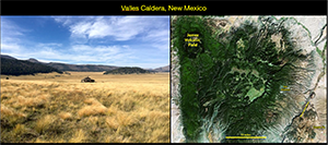
|
| Fig. 69. A final look at a couple "volcanic related" feature, but of organic origin. "Clinker beds" form where underground coal beds catch fire and burn hot enough to melt rocks. In nature, lightning strikes and wildfires can cause coal seams to catch on fire and they can burn slowly underground, possibly for centuries. If they get hot enough they can melt encasing rock. The image on the left shows the igneous appearance of a clinker bed associated burned coal seams in the Powder River Basin, Wyoming. On the right, the image shows clinker beds capping Coal Mine Mesa on the Navajo Reservation near Tuba City, Arizona. | 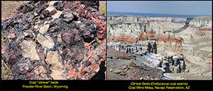
|
| Fig. 70. Coal seam fires can be natural origin or from human activity. Thie images shown on the left here show a coal seam fire that was started by a lightning strike on a nearby tree. The figure on the right show a coal seam fire cause by an accident associate with coal mining near Craig, Colorado. In 2022, the Federal Office of Surface Mining reported at least 259 “known” underground coal fires in 21 states. Although some are natural (started by lightning and wildfires), most are associated with mining activity. Pennsylvania has most. Some that started in the 1960s are still burning. | 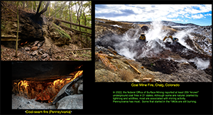
|
| Fig. 71. The Volcano at The Mirage in Las Vegas was the “2nd longest volcanic eruption in US history!” It first erupted November 22, 1989 but went extinct on July 16, 2024. | 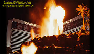
|
| Fig. 72. Many other underground fires of human origin occur in our modern world. About 8,300 landfill fires occur each year in the United States (U.S. Fire Administration). Some landfill fires, once started, can burn for years. Large crevasses can open in burning landfills and are extremely hazardous (a good reason to to walk on or build on top of old landfills. | 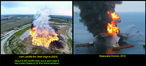
|
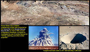
Fig. 73. Finally, another human source of igneous activity: underground testing of nuclear weapons. This a Google view of Yucca Flat at the Nevada National Security Site. All the craters were test sites. Storax Sedan was a shallow underground nuclear test conducted at the Nevada National Security Site on July 6, 1962, as part of Operation Plowshare, a program to investigate the use of nuclear devices for “mining, cratering, and other civilian purposes.” Can you imagine what kinds of unusual igneous mineral you could find here (in the distant future)? |
|
Selected ResourcesThis website contains graphics from numerous sources (including photographs and maps compiled by the writer). Many of graphics came originally from US Geological Survey websites compiled starting in the 1990s (including many that no longer exist online). Base maps were compiled and modified from sources including the NationalAtlas.gov. Satellite imagery derived from NASA.gov, Google Earth and NOAA's nowCOAST website were also used. Note that there are many faults not show on the maps, and newer maps and data are probably available. All graphics used from sources on the Internet came from public domain websites, but may have been modified and edited to improve visual quality or highlight significant features.The best places to start looking for recent information about earthquake faults in California are the following websites: U.S. Geological Survey, Volcano Hazards Program (web portal): https://www.usgs.gov/vhp . This research program includes: • Alaska Volcano Observatory (AVO) [https://avo.alaska.edu/] • USGS California Volcano Observatory (CalVO) [https://www.usgs.gov/observatories/calvo] • USGS Cascades Volcano Observatory (CVO) [https://www.usgs.gov/observatories/cvo] • USGS Hawaiian Volcano Observatory (HVO) [https://www.usgs.gov/observatories/hvo] • Yellowstone Volcano Observatory (YVO) [https://www.usgs.gov/observatories/yvo] Smithsonian Institution, National Museum of Natural History, Global Volcanism Program (web portal): https://volcano.si.edu/ National Park Service, Geologic Resources Inventory (portal to numerous national parks that have volcanoes and igneous rocks): https://www.nps.gov/subjects/geology/geologic-resources-inventory-products.htm |
| This page is <https://gotbooks.miracosta.edu/fieldtrips/volcanoes/> Last modified: 1/8/2025 (P. Stoffer). |