
Calavera Hills Volcano, Carlsbad, California |
Field Trip to the Ancient Shorelines and the Calavera Hills Volcano |
This field trip is to explore the geology of the Calavera Hills Nature Preserve in Carlsbad, California. This open-space preserve park is host to an ancient volcano that erupted along the coast sometime between 13-18 million years ago. The internal features of the old volcano are exposed in a cut used to mine rock in the construction of Calavera Lake Dam. The nature preserve encompasses 256 acres of upland coastal sage scrub habitats. Rabbits, coyotes, raccoons, fence lizards, horned lizards, barn owls, road runners, hawks, tree frogs, garter snakes, rattlesnakes, and other wildlife inhabit the preserve. Lake Calaveras is a small man-made reservoir that is host to egrets, herons, ducks, coots, and other waterfowl. |
Click on images for a larger view. |
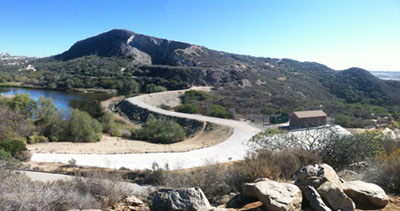 Figure 1. The Calavera Hills volcano is the eroded remnant of a larger volcano. Its peak is the highest point in Carlsbad. The hard-rock core of the volcano was mined for construction of the Calaveras Lake dam. |
Directions to the Calavera Hills Nature PreserveTo get there: Follow College Avenue south for about 1 mile (south of Highway 78).Turn left on Tamarack Avenue and follow the road down through the neighborhood until you see the trailhead that leads to the dam. Park on Tamarack Avenue or Strata Drive near the trailhead that leads to the dam. The volcano is on the opposite side of the dam. The drive to the parking area along Tamarack Avenue is approximately 2.1 miles (10-15 minutes drive) from MiraCosta’s Oceanside campus. |
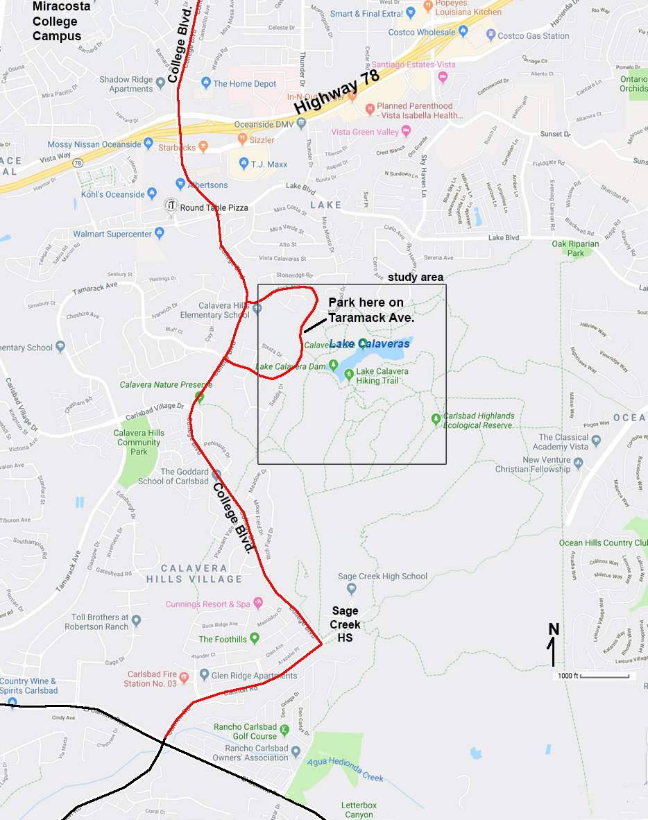 |
| Figure 2. Map of the region around the field-trip study area showing directions to the Calavera Hills Trailhead. |
Figure 3. Geologic map of the region around the Lake Calavera Hills volcano and Lake Calavera. |
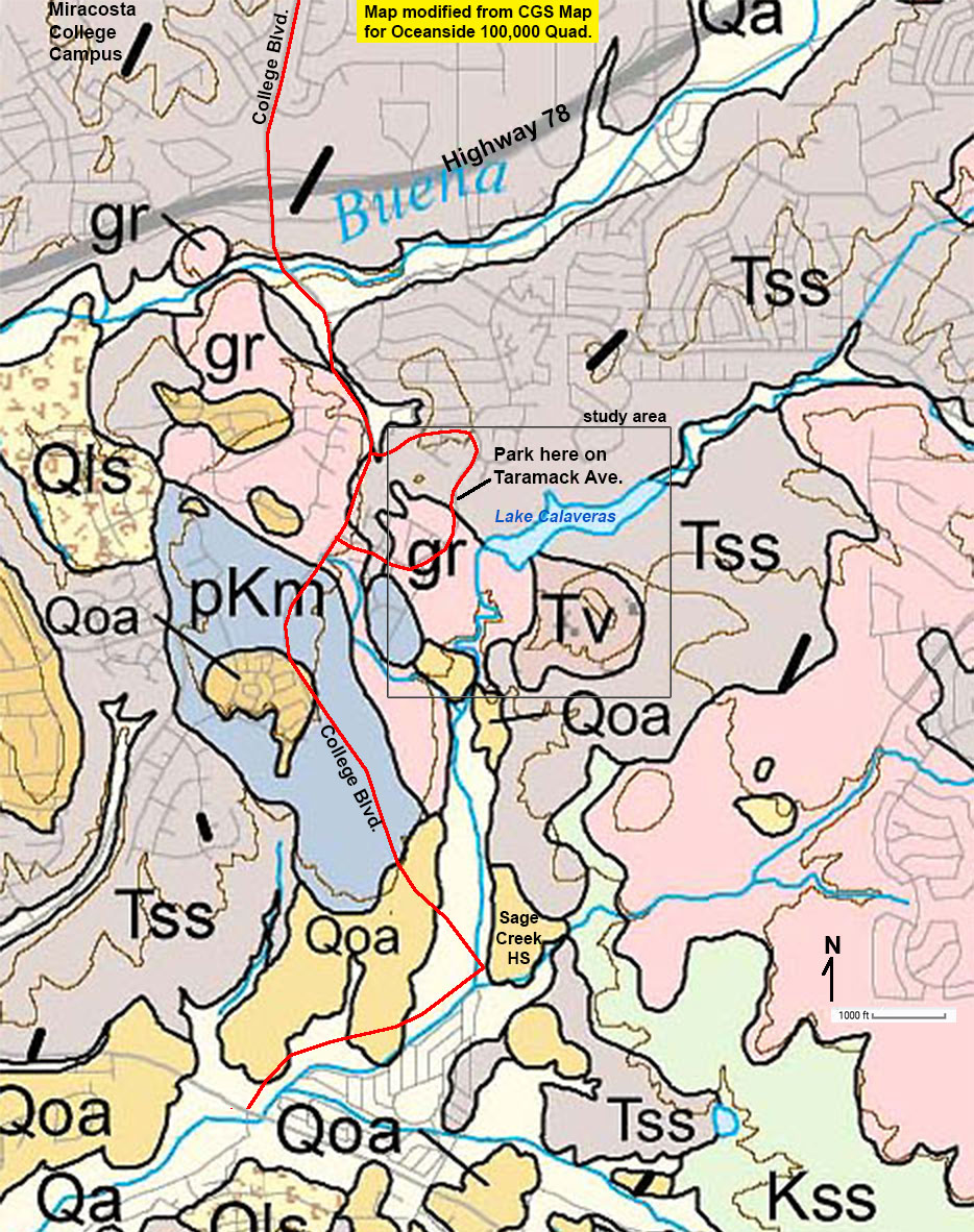 |
Symbols for the geologic mapQa - young alluvial stream depositsQoa - older Quaternary alluvial deposits preserved on upland surfaces along valleys Qls - landslide deposits (active and/or older Quaternary landslide deposits) Tv - Tertiary volcanic rocks — Calavera Hills volcano, volcanic stock (plug) and cone deposits. Tss - Tertiary sedimentary deposits (sandstone and other fine-grained sedimentary rocks) Kss - Cretaceous sedimentary rocks (sandstone, shale) that has yielded a variety of fossils. gr - granitic rocks (mostly tonalite, a variety of felsic, quartz-rich plutonic rock, formed within the Peninsular Range volcanic arc during the Cretaceous Period, about 80-100 million years ago.) pKm - pre-Cretaceous metamorphic rocks, mostly oceanic sedimentary and igneous rock formed in an oceanic setting prior to the formation of the Peninsular Range volcanic arc. |
|
| Map modified from: Geologic map of the Oceanside 30'x 60' Quadrangle, California: California Geological Survey, Regional Geologic Map No. 2, 1:100,000 scale. |
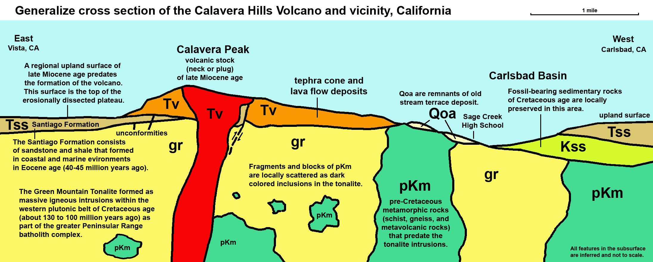
| Figure 4. A generalized cross-section (north to south) across the Calavera Hills volcano and plateau region in northern coastal San Diego County. |
Figure 5. Map showing details and locations of the field-trip stops on the trail map and geologic map. |
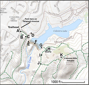 Figure 3. Topographic map with stops. |
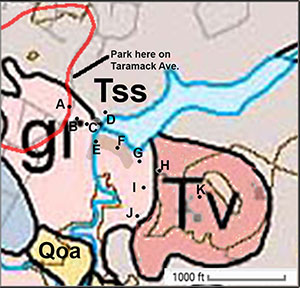 Figure 4. Geologic map with stops. |
| The trailhead is on Taramack Avenue. Dashed lines are hiking trails. Field trip stops are labeled dots A to K. |
||
Figure 6. Geologic map detail showing location of field-trip stops. The colors represent the surface area expression of different rock units (described below under Local Geology). |
||
Map Legend Symbols gr = granitic rock (Cretaceous, tonalite) |
Lake Calavera - an artificial lake and now a major habitat in a wildlife refugeLake Calavera has an interesting history. For thousands of years before the communities of Carlsbad, Vista, and San Marcos came into existence, the area was host to native American peoples. These communities utilized the natural resources of the the coastal sage and chaparral habitat on the upland interior plateau of the Calavera Hills area and the riparian habitat along Sage Creek. Shell material in small middens indicated that the creek was a water supply along the seasonal migration routes between the coastline and the oak forests in the mountains to the east. Today the valley of Sage Creek and the reservoir are protected as an important wildlife refuge and corridor in the modern urbanized landscape. |
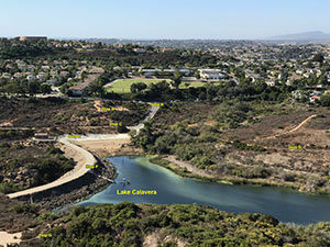 |
| Figure 7. View looking north from the top of the Calavera Hills volcano toward Lake Calavera (showing the locations of Stops A to G). The greenish color in the water is caused by upwelling currents moving surface waters of the lake. Upwelling brings fish to the surface and are places where shore birds wait to feed. |
Stop A. Meet at the Calavera Hills Trailhead on Taramack Avenue.
|
Local GeologyOn this field trip we will be observing 4 kinds of geologic materials that have different origins, from oldest to youngest as follows: 1) The Green Valley Tonalite is a crystalline, intrusive igneous rock (similar to granite in appearance and texture). Up close, you can see the medium to coarse-grained mineral crystals of feldspar (white), quartz (clear to gray), biotite (black), and other dark mineral grains (magnetite and other mafic silicate minerals). The Green Valley Tonalite is a common bedrock exposed throughout the Peninsular Ranges in the San Diego County region. The tonalite is an intrusive igneous rock unit that was cooled slowly at depth, and was subsequently uplifted, and exposed by erosion. It is shown with the symbol gr on the local geologic map (Figures 2 & 4). The tonalite is associated with an ancient volcanic arc complex that existed along the western margin of the North America continent that was actively forming in this region during the Late Cretaceous Period, roughly 100 to 80 million years ago. 2) The Santiago Formation is a sedimentary rock formation of Eocene age, deposited about 40-45 million years ago. Locally, the rock formation locally crops out in the hillside in northern San Diego County. It is also called the Scripps Formation in some literature. The age of Santiago Formation is based on fossils and other data. The exact age of the Santiago Formation in this location is unclear, but by its physical characteristics it is considered equivalent in age to the Del Mar Formation and Torrey Pines Sandstone Formations exposed in the sea cliffs along the coast between Carlsbad and a Jolla, California. Locally the rock consists of a fine-to-coarse-grained sandstone, white-to-pale gray colored, and is a moderately to well-sorted arkosic sandstone (rich in feldspar grains). Fossils removed from locations nearby suggest that the formation was deposited in coastal settings: beach, nearshore, and lagoon or bay settings. The Santiago Formation is shown at Tss on the geologic maps (Figures 2 and 4). 3) Volcanic rocks, undivided: locally these consist of light-to-dark gray, black, to brownish colors. These are the rocks exposed in and around the Calavera Hills volcano (see Tv on the geologic maps; Figures 2 and 4). The volcanic rock locally is of dacite composition. Dacite is a fine-grained extrusive igneous rock intermediate in composition between andesite and rhyolite (felsic igneous rocks). The mineral grains in the rock are too small to see with the naked eye. Rare inclusions of the tonalite occur in the volcanic rock. 4) In addition, there are unconsolidated sediments exposed on the surface.. These deposits are weathering products derived the the breakdown of the bedrock in the area (regolith and soil). Some sediments were transported into the area along ancient streams and deposited locally (as alluvium). These deposits locally contain stream-rounded cobbles derived from distant sources. |
| Figure 8. How erosional processes influence the size, shape, and sorting of sediments. |
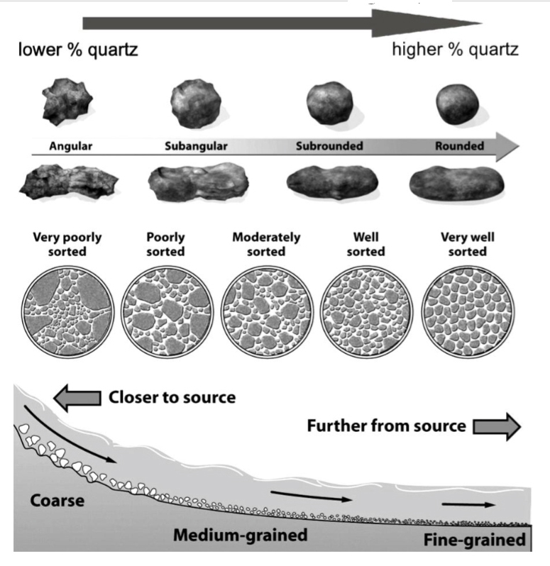 |
| This diagram is useful for studying the soils and sediments along the trails in the Calavera Hills Nature Reserve. It help to interpret the origin of the sedimentary deposits and soils at the various stop locations. As sediments are transported along streams, rolling and bouncing for miles along river bed as its moves down slope form sources in the mountains to the coast. Abrasion smooths the sharp edges of mineral grains or rock fragments. Stream current flow sort sediments into separate size fractions. Coarser sediments occur closer to source areas. Sorted sand and finer sediments have traveled longer distances along streams and by wave action along coastlines. |
Figure 9. Basic geologic principles used for relative dating |
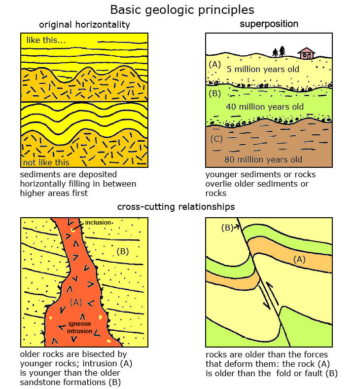 |
The Law of Original Horizontality The Law of Superposition shows that in a location where sediments or lava flows have formed and remain undisturbed, the oldest layers are on the bottom, the youngest layers are on top. The Law of Cross-Cutting Relationships dictates that layers of rock are older than the forces that change them. For instance, a volcanic intrusion is younger than the rocks they cut through. Also, a fault or structural changes are younger than the rocks they cut through. All four geologic principles can be observed in the Calavera Hills area. |
Figure 10. Different kinds of unconformities used for relative dating of rock formations. |
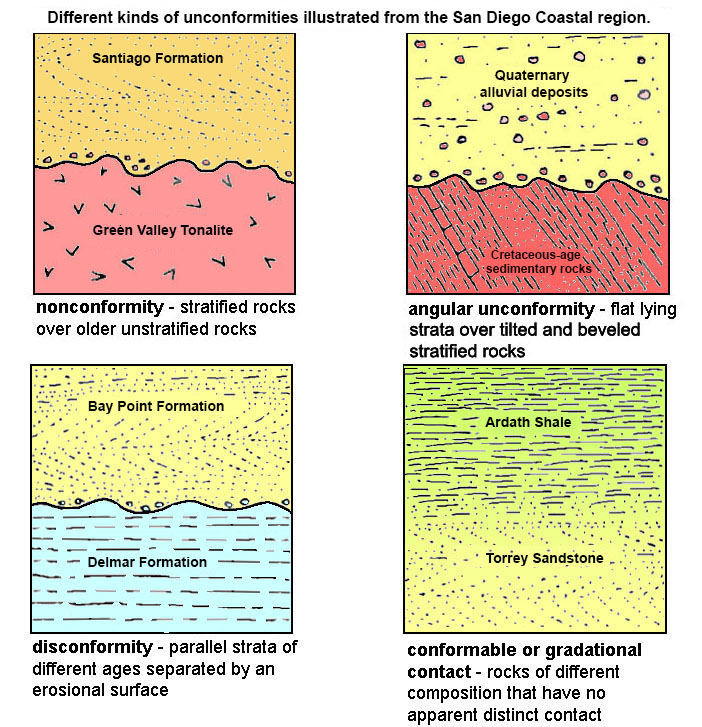 |
An unconformity is simply an ancient surface preserved in a succession of rocks, and may represent a “gap in time” when surface erosion occurred and/or sediments or volcanic material were not deposited. A non-conformity exists between the Green Mountain Tonalite and overlying Santiago Formation. Both an angular unconformity and a disconformity can be observed along the boundary between the Santiago Formation and the overlying volcanic deposits. They are likely the same unconformable surface, but taking different forms at different locations. The angular unconformity can be seen in the warped layers near a fault. |
Stop B. Overlook of the Calavera Hills Nature ReserveFollow an unpaved side trail to overlook on the west side of the trailhead. Walk down the dirt path to a series of angular-shaped boulders of granitic rock (Green Valley Tonalite) near the steep drop off into the valley near the power lines. Figure 11 shows a panoramic photo taken from the Stop B overlook that shows many of the locations and features to discuss on this field trip. Compare this photo to the maps (Figures 1-4). |
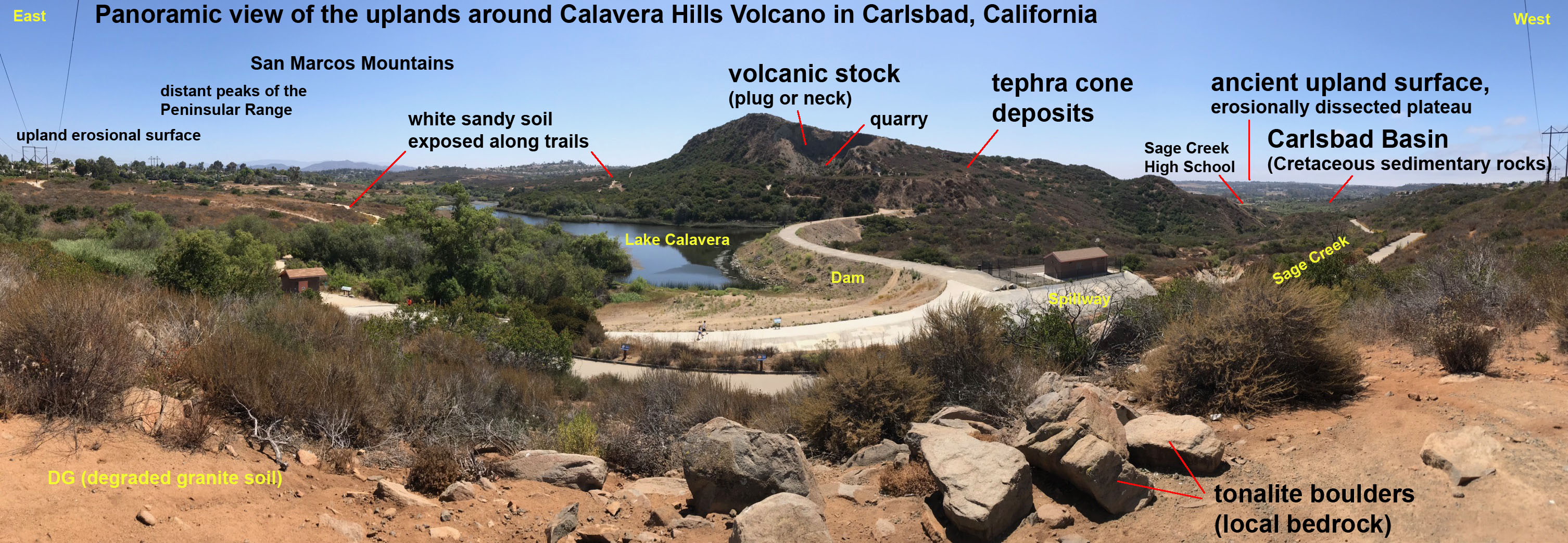
| Figure 11. This photo is an east-to-west panoramic view (looking south) across the Calavera Lake Dam and Calaveras Peak, the highest point in Carlsbad, elevation 513 feet. In contrast, the elevation of the top of Lake Calavera Dam is about 220 feet. The original name of the hill is Cerro de la Calavera (translated from Spanish, Skull Hill). How it got its name is unknown. The peak is also known as the Calavera Hills volcano, a remarkably small volcano compared with others in California. |
From this location it is easy to see the volcano where is stands relative to a regional upland surface, a geographic feature called an erosional dissected plateau. If you west look down the valley of Sage Creek from this location you can see a broader valley beyond Sage Creek High School (in the vicinity of the El Camino Real near Cannon Road). Sage Creek joins Agua Hedionda Creek which, in turn flows into Agua Hedionda Lagoon. When they excavated the foundation for homes and building in the area near the El Camino Real. Many rare and unusual fossil were recovered including shells of ammonites and teeth and bones of Ankylosaurs. According to the geologic map, what is the age and composition of the rock formation (hint: about 70 million years)? |
Stop C. Solar System Walk (Trailhead)Follow the main trail down from the trailhead to the intersection with the valley trail and turn right. Proceed to a sign describing the sun. This sign is the first of a series of signs along the Solar System Walk describing the planets of the solar system spaced proportionally along the 1 mile trail from this location (the Sun) to Pluto - down the trail to Sage Creek High School. Across the trail from the Sun sign the local bedrock of Green Mountain Tonalite is partial exposed.Granitic rocks break down when exposed to weathering, soft minerals dissolve or decay, but harder minerals like quartz and feldspars resist decay and become grains of sediment. Coarse-crystalline rocks like the local granite or tonalite becomes a coarse, sandy sediment called grus. If you go to a local business that sells rock, gravel, sand, and soil products, many of these places sell a product called DG (meaning degraded granite, derived from grus deposits) (see Figure 12). Note: we can see grus (DG) forming in several location in and along the trails, such as in this area. It is naturally forming here. |
Stop D. Examine soil from the Santiago Formation and a view of the volcano and lake from the Lake Loop TrailFollow the Lake Loop Trail no the north side of Lake Calavera for several hundred feet until you reach a wooden fence area along the trail that give you a view of the lake and Cerro de la Calavera (the name for the hill on the south side of the lake). The hill is also known as the Calavera Hills volcano.At this location look down and examine the sandy character of the soil on the trail (Figure 13). This is basically beach sand that has weathered from the Santiago Formation. This area was a beach or nearshore bar when sediments accumulated back in Eocene time (about 45 million years ago) that eventually was preserved as what is now the Santiago Formation. |
| Figure 12. Close-up views of grus (DG) derived from the tonalite. | 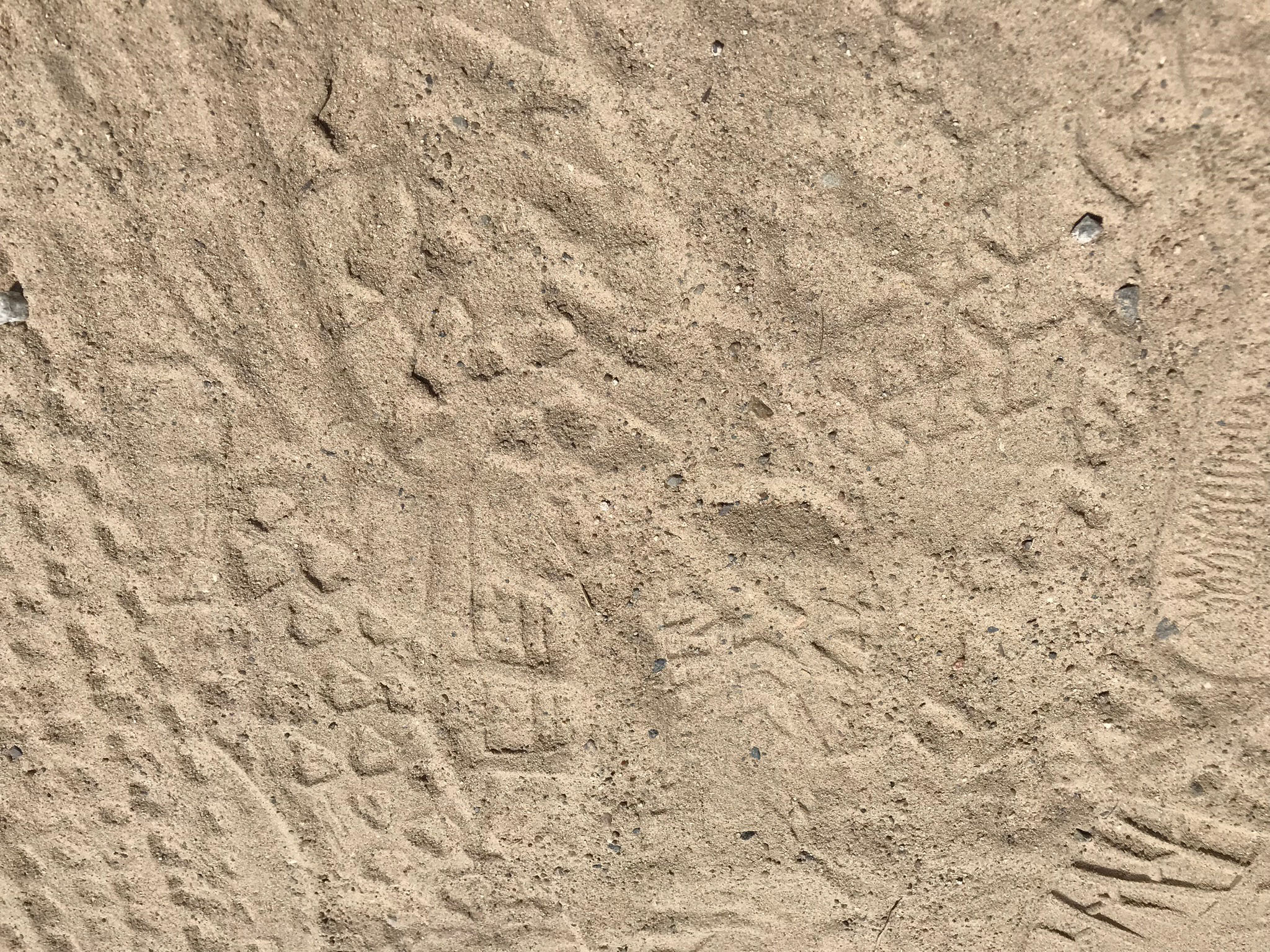 Fig. 9. Grus (DG) soil form on tonalite. |
Fig. 10. Beach sand from the Santiago Fm. |
Note the angular shape of the grains, the poor sorting, and the mixed mineral composition dominated by feldspar. |
||
| Figure 13. Close-up view of beach sand that is exposed on the trail where sandy soil derived from of the Santiago Formation. | ||
| Note the high degree of rounding of the fine-grained, well-sorted sand, and that the mineral composition is dominated by quartz. This sand comes from the weathering of the ancient beach and coastal deposit of the Santiago Formation. |
| Figure 14. Outcrop exposure of dipping sedimentary layers of the Santiago Formation of Eocene age on the west side of the Calavera Hills volcano. Note the light-gray color and fine, sandy character of the soil covering parts of this outcrop. |
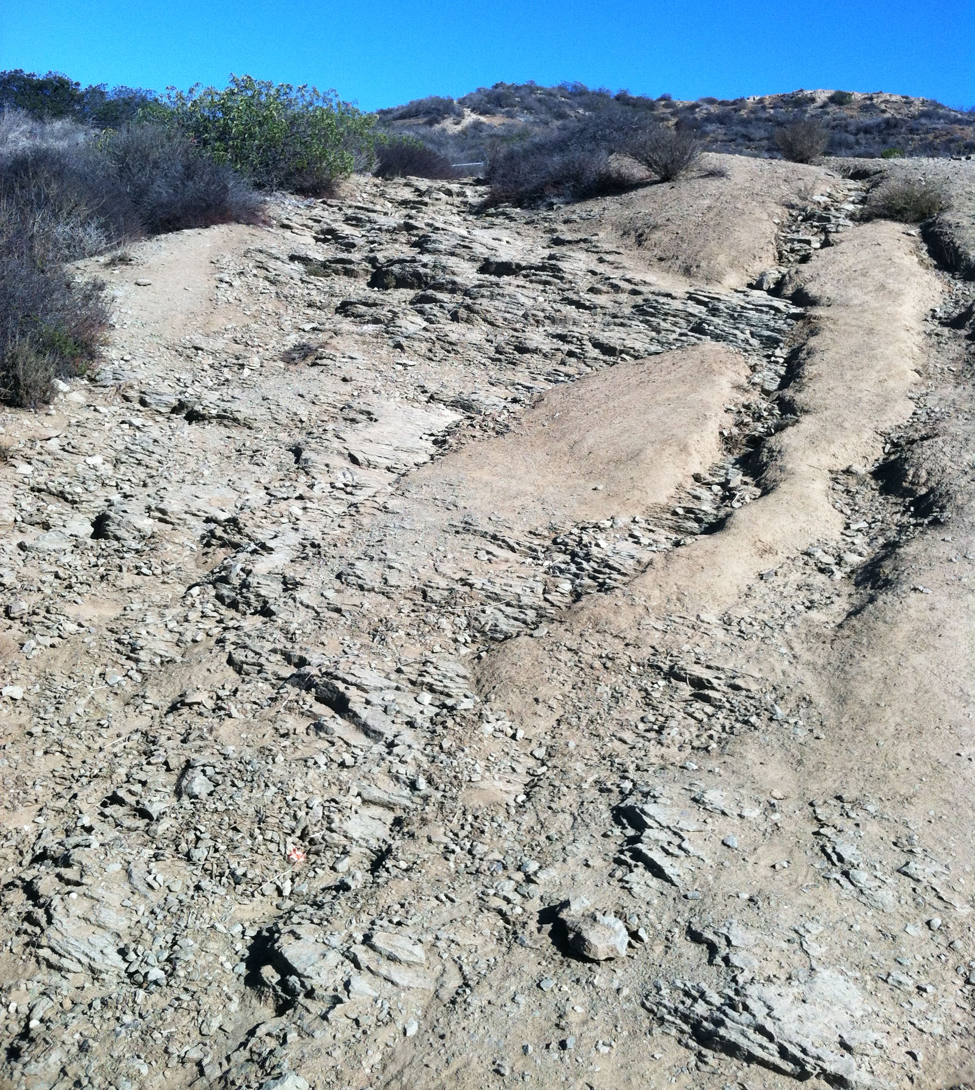 |
On the south side of the Calavera Hills volcano there are sedimentary rock layers exposed that display a gradual dip angle to the north (Figure 12). These layers were originally deposited in horizontal layers (Law of Original Horizontality), but were then uplifted and tilted by tectonic activity prior to the formation of the volcano. To the north of the volcano area is the small Carlsbad Basin where sedimentary rocks of Cretaceous age are locally preserved (but not well exposed) in the valley of Hedionda Creek (see Figure 3).When the neighborhoods were constructed in the are a large number of beautifully preserved Cretaceous-age marine fossils were recovered from the area that are now in area museums and college fossil collections. |
Figure 15. Examples of inclusions preserved in the Green Valley Tonalite. |
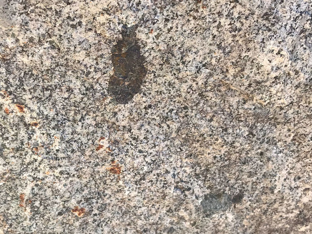 |
| Figure 15 shows a couple dark blotches of mafic rock that are incorporated into the lighter colored crystalline rock of the Green Valley Tonalite. The Law of Inclusions indicates that the dark inclusions are fragments of older metamorphic rock that were incorporated into the magma body that cooled to form the lighter, speckled tonalite. The geologic map (Figure 3) shows that there are older metamorphic rocks nearby (indicated as pre-Cretaceous age - pKm on the map) in the neighborhood nearby along College Avenue. As the magma bodies that formed the Green Valley Tonalite intruded into the pre-existing bedrock, some of the surrounding country rock broke off and survived melting before being incorporated into the cooling magma. The crystalline nature of the tonalite suggests that it cooled very slowly, possibly in a magma chamber or igneous pluton many thousands of feet below the surface beneath the ancient Peninsular Ranges volcanic arc. |
Stop E. Lake Calaveras Dam (Spillway Overlook Area)This stop is to simply look at the construction of the dam and the spillway. The dam was originally constructed in 1942 to be used as a source of drinking water for Carlsbad. After the city was incorporated, the city started getting its drinking water from the Colorado River, and this reservoir was largely forgotten by the late 1960s. Since then, massive regional development has taken place, and the lake and dam now serve other purposes (flood control and wildlife habitat). Some attempts were made to remove the dam, but this was later rejected for environmental reasons. |
Stop F. Middle of the DamNote the large blocks of volcanic rock used in construction of the dam and along the trail on the dam. Lake Calavera dam and reservoir was completed in 1940. The dam is about 67-ft. high and 490-ft across, and took about 85,000 cubic yards of material to construct. The total storage capacity of the lake is 520 acre-ft. You can see large blocks of rock on the dam that were removed from the quarry on the volcano. From near the middle of the dam you can look down stream along the canyon of Sage Creek. Along the sides of the stream valley you can see step-like benches and small hilly features that are remnant of ancient elevated stream terraces. These ancient stream terraces locally preserve old alluvial flood plain deposits (show as Qoa on the geologic map; Figure 3). In many places around this region old river terraces are preserved on hillsides along many of the major river drainages. Many of these Qoa deposits preserve rounded stream cobbles that were carried into the valley from sources a long way away (possibly even from Mexico before the formation of the San Andreas Fault system and Baja California separated from Mexico, creating the Gulf of California). Some of the cobbles display rounding similar to the beach cobbles found along the modern San Diego beaches. |
Stop G. Trail from the dam to the rock quarry on Calavera Peak.Follow the trail to the left on the south side of the lake. Be careful as you walk, this is a rocky trail that wind uphill into the quarry. Along this trail pay special attention as to how the appearance and composition of the soil changes as you walk along the trail from the dam to the quarry (Stop H). |
What soils can tell us about the geology history of an area?Geoscientists look at soils for a variety of reasons. Soils can tell us much about the bedrock geology and climate history of an area. Also, in many areas there is little or no exposed bedrock to easily examine. The three different kinds of bedrock described in Local Geology (above) produce different kinds of soil. Based on what you observe in the soil, what rock formations probably exists in the bedrock along this lower and upper sections of trail between the dam the quarry (Stop H)? |
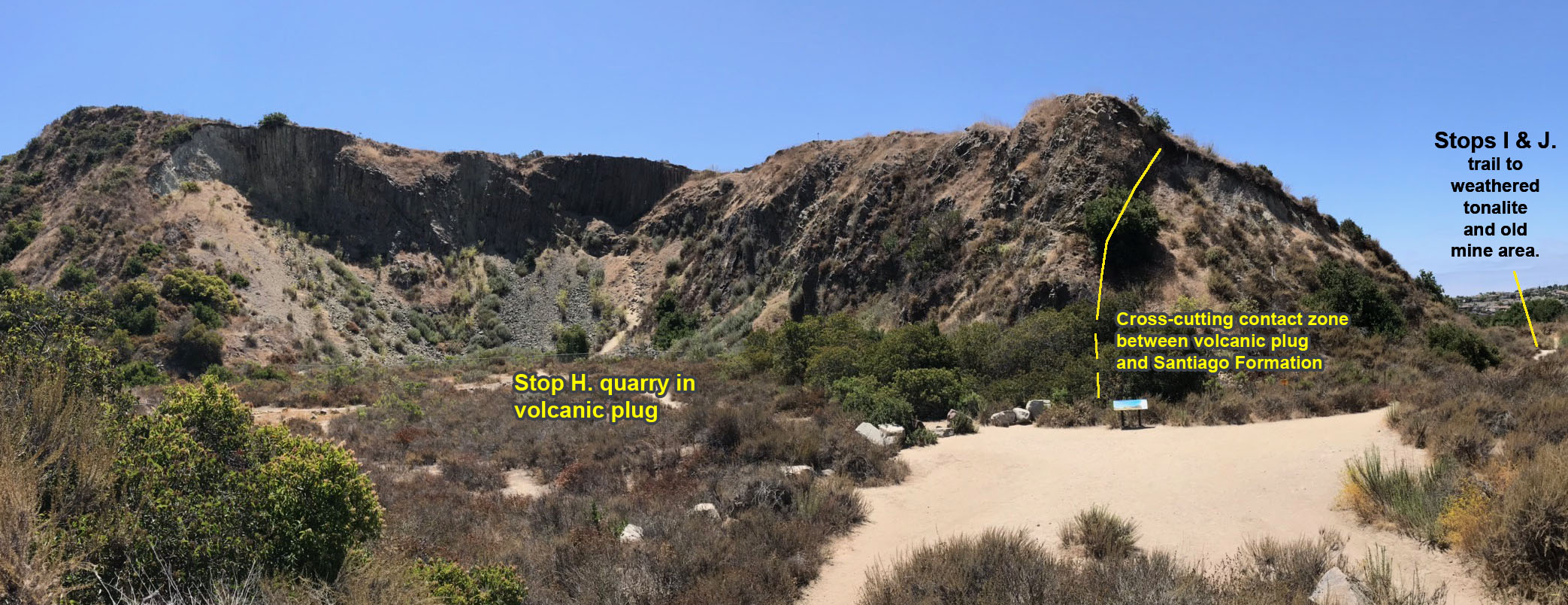
Figure 14. View of the dacite rock quarry in the Calavera Hills volcano (showing locations of Stops H, I, and J. Stop K is located on the peak (of Cerro de la Calavera) above the quarry on the left. |
Stop H. Volcanic Plug and Rock QuarryAt this stop you have arrived at the center of the rock quarry in the Calavera Hills volcano. Around you can see the gray rock walls of rocks that has an abundance of vertical cracks resulting in columnar jointing. Columnar joints form in pools of cooling lava as the shrinks in volume at the lava solidifies. Stresses in a relatively homogeneous body of cooling lava result in a hexagonal or polygonal pattern of cracks (similar to cracks that form in drying mud puddles). The volcano is an eroded remnant of an original volcanic cone. The quarry mined they harder rock of the stock of the volcano (the passage that molten material flowed to the surface beneath crater of a volcano. The actual age of the volcano is disputed, but estimates suggest that the relative age is late Tertiary Period (or Neogene Period). The USGS map gives it an age of the Miocene Epoch (between 23 and 5.3 million years). The absolute age of the Calaveras Hills volcano is somewhat disputed. The volcano probably formed in the time frame of other volcanic features in the region including the Scripps Dike (or Dike Rock) in La Jolla that has been absolute age dated to being 13.89 million years (middle Miocene age) (source: Day and others, 2019). Volcanic rocks of middle Miocene age are known from seafloor sample collected San Diego Trough region offshore. Near Temecula, California (about 25 miles to the northeast), volcanic rock know as the Santa Rosa Basalt has been dated to an age of about 8.7 million years (Hawkings, 1970). The volcanic stock, tephra cone, and lava flows rest unconformably on an ancient erosional surface that predates the volcano. This ancient surface is still visible as the erosionally dissected plateau that exists throughout the region in eastern San Diego County. It can be easily seen throughout the vicinity of the Calavera Hills volcano (see Figures 7, 11, and 18 for different views showing the upland surface of the plateau). This surface probably correlates to the Perris surface that underlies the Santa Rosa volcanics that erupted about 8.3 million years ago (Woski and Howard, 1987). |
Dacite volcanic plug crosscutting Santiago Formation at Stop H.Along the trail on the west side of the quarry it is easy to see an uplifted block of the Eocene-age Santiago Formation in contact with the the border of the Miocene-age dacite volcanic plug of the volcano. There is a reddish-colored zone along the boundary where heat from the volcanic material partially baked (local contact metamorphism) the sedimentary rocks of the Santiago Formation. The steep orientation of the sedimentary layers exposed in the cut suggest that layers were forced up as the volcano formed. These deformed layers also suggest faulting may have occurred in the area before and/or during the formation of the volcano. It is likely the molten material that formed the volcano had migrated to the surface along fault or fracture zone that extended deep into the crust in this region. Looking back north across the dam from this location, can you discern the possible location of a fault that may run across the valley (Hint: look at the locations of Stops A, B, and C.). Where might there be a fault (not that not all faults are active; there may actually be no fault in this location). What alternative explanation might explain the relationship of the tonalite and Santiago Formation on the opposite side of the valley? |
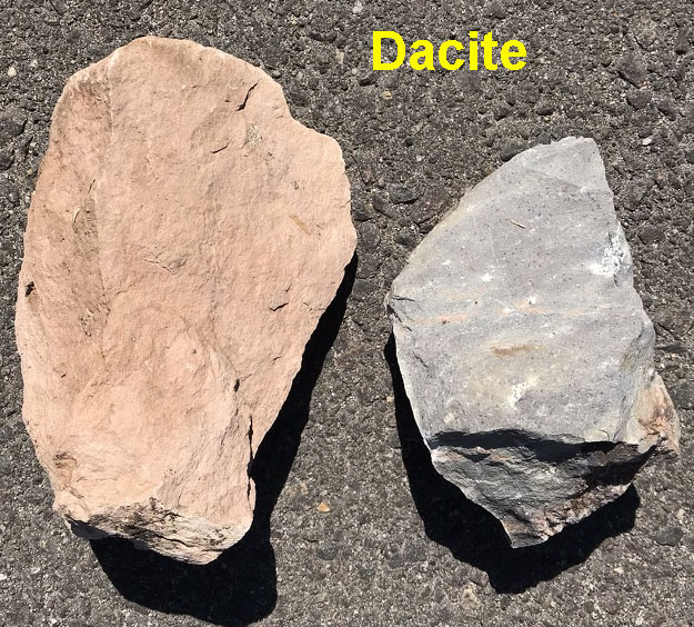 |
Figure 15. Dacite is a type of an extrusive igneous [volcanic] rock. These samples are from the nearby Morro Hills volcanic field near Bosnall and Falbrook, CA. These samples are nearly identical to the volcanic rock (dacite) exposed in the Calavera Hills volcano. |
Stop I. Spheroidal-weathering features preserved in the tonalite.Continue down the trail on the west side of the quarry. As you walk, notice the changes in the appearance of the soil along the trail. Along the way you may see exposures of the old bedrock that display usually ring-like circles in blocks of deeply weathered blocks of the tonalite. This is a result of spheroidal weathering. It is caused by the repeated process of wetting and drying as water soaks into fractures in the granite, gradually causing the granitic bedrock to break down (forming DG). |
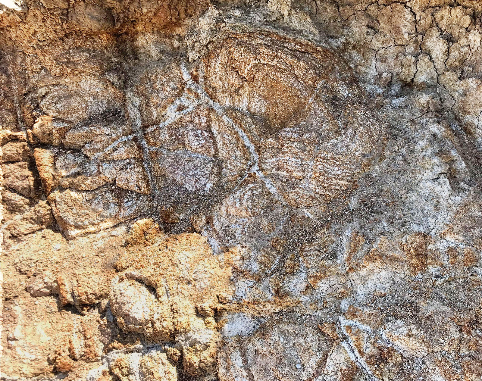 |
Figure 16. Spheroidal weathering and healed fractures in the tonalite exposed along the trail. In this location note the relationship of some of the white fractures that cross the spheroidal weathering circular lines. Based on basic geologic principles [Figure 9], which formed first? How might you interpret the geologic history of this rock (relative to the formation of the volcano)? |
Stop J. An abandoned mine.Figure 17. An abandoned mine along the boundary between the tonalite (below) and a fine-grained lava flow (above). The picture on the left show the entrance of the mine below the base of the lava flow (picture from field guide by John Turbeville. The picture on the right was taken after the mine was seal off in 2018. The mine audit was was dug probably in the early 20th century by prospectors searching for precious mineral. It is unclear if they recovered anything significant. |
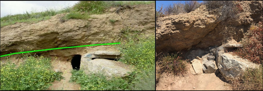 |
Based on the Law of Superposition, what does this boundary tell us about the age-relationships between the lava flow and the underlying tonalite? What might explain why there is no Santiago Formation exposed in this location? |
Stop K. Top of the Calavera Hills VolcanoStop K is on the peak of Cerro de la Calavera (the historic name of the Calavera Hills volcano). The top of the peak (elevation 513 feet) is the highest point in Carlsbad. |
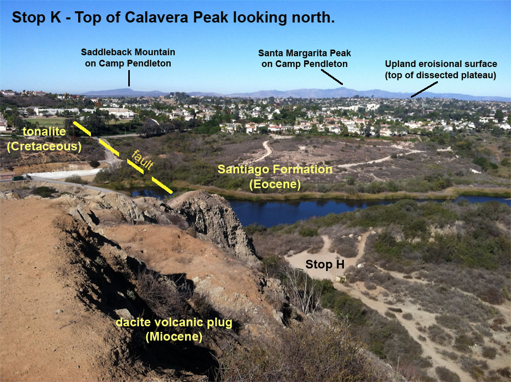 |
| Figure 18. View looking north from the top of the Calavera Hills volcano. The upland surface of the erosional-dissected plateau is clearly visible. The high peaks of mountains on Camp Pendleton are in the distance. |
|
| The fault shown on Figure 18 is inferred by the juxtaposition of the tonalite adjacent to the Santiago Formation. However, the fault is covered by surficial deposits. The juxtaposition could be inferred another way, that the tonalite was a rocky headland or sea stack when sediments of the Santiago Formation were deposited. It could be both scenarios as well. | |
""One rock, two geologists, three opinions." |
|
Figure 19. View looking west from the top of the Calavera Hills volcano toward the San Marcos Mountains. |
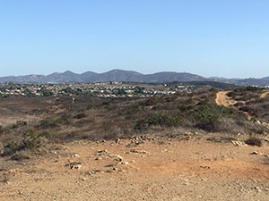 |
| The upland surface of the erosional-dissected plateau surrounding the Calavera Hills volcano is clearly visible. The high peaks peaks of the San Marcos Mountains and part of Palomar Mountain are visible in the distance to the west. The San Marcos Mountains form the western mountain front of the Peninsular Ranges. This upland surface is very similar to the mesa region east of of Torrey Pines area, and may have formed in the same manner caused by the rise and fall of sea level in late Miocene time into early Pleistocene time. The ancient erosional surface of the plateau was part of an embayment or coastal plain (depending is sea level was high or low). At the highest point, the shoreline probably extended all the way east to the base of the mountains. The whole western coast of San Diego is slowly rising very slowly, with an estimate of a rate of about 0.5 inches per century. |
Other similar volcanic areas in western San Diego CountyAt least three areas are known in western San Diego County where Miocene volcanic activity resulted in landscape features can be seen on the landscape today. The 3 location seem to appear in a linear alignment, suggesting they may be associated with an aborted rift (fault). |
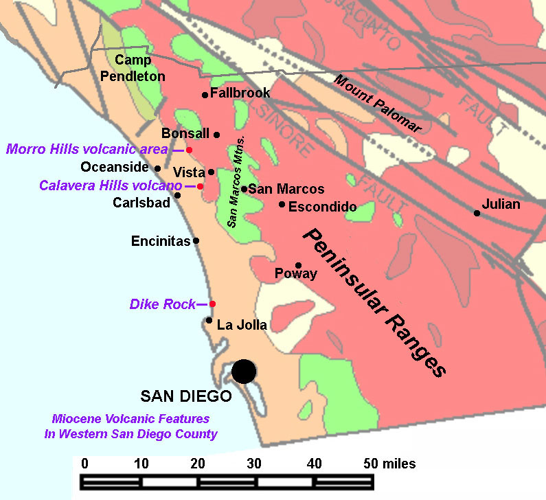 |
| Figure 20 is a generalized geologic map of the San Diego region showing the location of the Calavera Hills volcano (in Carlsbad), Dike Rock (in La Jolla) the Morro Hills volcanic field (near Bosnall). |
Dike Rock, Scripps Beach, La Jolla, CaliforniaSan Diego County is host to a variety of volcanic rocks. The core of the Peninsular Ranges is made up of intrusive igneous crystalline rocks and volcanic rocks of Mesozoic age. These rocks include the tonalite expose in the Calavera Hills Preserve and the nearby San Marcos Mountains and the distant ridge of Mount Palomar. These rocks are much older and different than younger intrusive and volcanic rocks exposed in several locations around western San Diego County. Three well-known localities of Miocene age volcanic rocks include Dike Rock (on the beach about 1,500 feet north of the Scripps Pier in La Jolla, CA. |
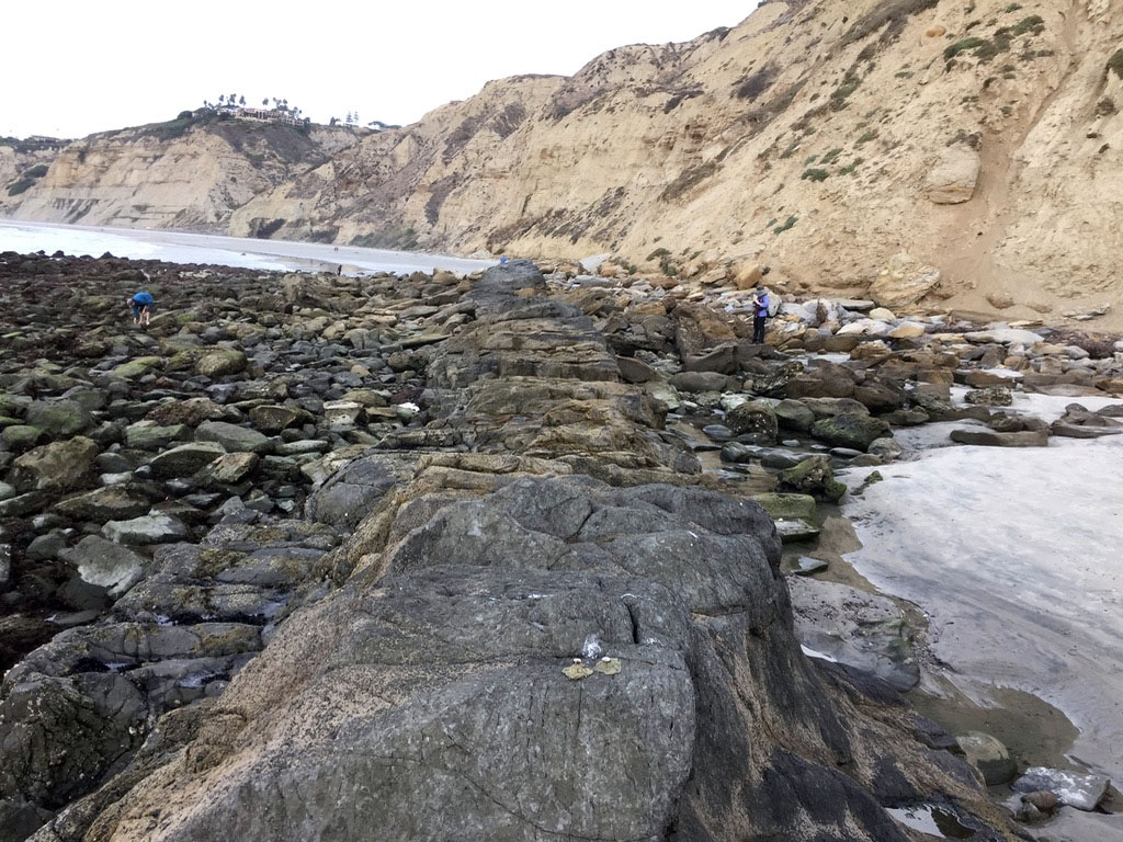 |
| Figure 21. Dike Rock is a volcanic dike exposed by wave erosion along the beach about 1,500 feet north of the Scripps Pier in La Jolla. The dike strikes in a northeast direction. Rubble eroded from the dike creates one of the largest tide pool areas along the San Diego coastline. |
The Morro Hills Volcanic AreaThe Morro Hills are located about 9 miles north of the Calavera Hills volcano (Figures 22 and 23). This area contains 7 separate igneous bodies (plugs and lava flow and tephra materials) that are composed of dacite, similar to the Calavera Hills volcanic rocks. The volcanic rock also rest unconformably on top of marine sandstone and siltstone bed of the Eocene Santiago Formation. The Santiago Formation rests unconformably on a surface of Cretaceous age crystalline intrusive igneous rocks (granodiorite, a rock similar to the Green Valley Tonalite in the Calavera Hills area. |
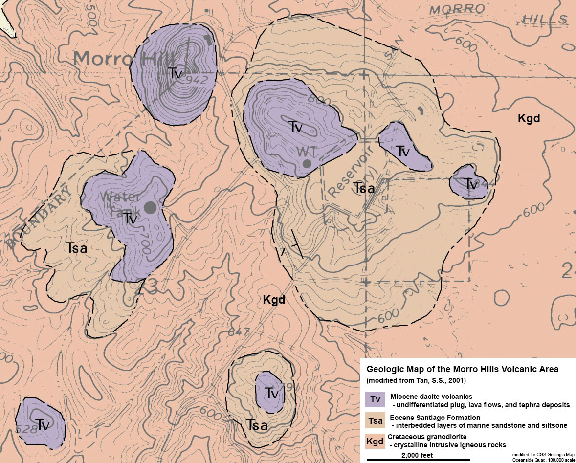 |
| Figure 22. The geologic map of the Morro Hills volcanic area shows seven small volcanic plugs (necks or stocks). These intrusive bodies (Tv) cut through and rest unconformably on top of an eroded surface on Tertiary sandstone (Tsa - equivalent to the Santiago formation in the Calavera Hills volcano area). The Santiago Formation rests unconformably on Cretaceous-age granodiorite (Kgd - similar in age to the tonalite in the Calavera Hills locality. |
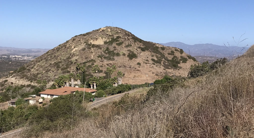
Figure 23. Morro Hill (or Sleeping Indian Hill) is one of the largest volcanic plugs in the Morro Hills volcanic field. The bedrock in the nearly symmetrically shaped dome consist of dacite (samples shown in Figure 15). |
 |
|
Selected References and ResourcesBrown, J.D., 1996, Geologic Formations of Western San Diego County: Carlsbad, California: GEI Consultants, Inc., 7 p. Day, J., Koppers, A.P, Mendenhall, B., and Oller, B., 2019. The ‘Scripps Dike’ and its implications for mid-Miocene volcanism and tectonics of the California Continental Borderland. SEPM Special Publication. 110:43-55. (Society for Sedimentary Geology). Hawkins, J.W., 1970, Petrology and possible tectonic significance of late Cenozoic volcanic rocks, southern California and Baja California: Geological Society of America Bulletin, v. 81, p. 3323-3338. Kennedy, M.P., and Tan, S.S., 2007 (compilers), Geologic Map of the Oceanside 30’ x 60’ Quadrangle, California. California Geological Survey Regional Geologic Map No. 2, 1:100,00 scale. Includes several digital plates, geologic map, and a 26 page pamphlet describing geologic features. Tan, S.S., 2001, Geologic Map of the Morro Hill 7.5’ Quadrangle, San Diego County, California: A Digital Database: California Department of Conservation, Division of Mines and Geology. Turbeville, John, The Geology of Calavera Hills, North San Diego County, California: http://home.miracosta.edu/jturbeville/calavera%20hills%20%20final.doc. Walawender, M.J. Geologic History of San Diego County. San Diego Natural History Museum website: Woski, M.S. and Howard, A.H, 1987, Peninsular Ranges batholith, Elsinore Mountains, California. Centennial Field Guide Volume 1. Cordilleran Section of the Geological Society of America. Boulder, CO: Geological Society of America, p, 185-190. |