Field Trip to a landslide in Coyote-Harvey Bear County Park
|
|
Field-Trip Overview: Coyote Reservoir is an exceptional geology field-trip destination. The reservoir fills part of the linear valley of Coyote Creek Canyon. The Calaveras Fault zone runs along the western shore of the reservoir and the dam itself straddles (or was constructed within) the fault zone. The faults is an active earthquake fault—the fault displays evidence of aseismic surface creep and has experienced damage-causing earthquakes in the vicinity of the reservoir. This trip is to examine the landscape and geologic features around the dam and along the park's dam access road.
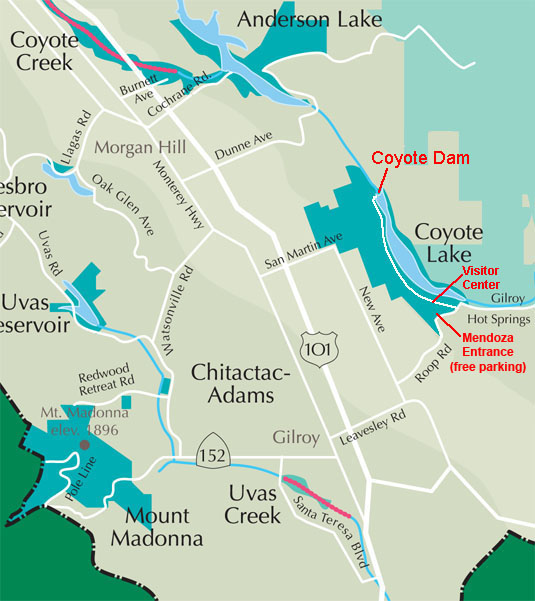
Directions: To get to Coyote Reservoir Dam take Highway 101 to the Leavesley Road Exit (California Highway 152 East).
Follow Leavesley Road east 1.7 miles.
Turn Left (north) on New Avenue.
Follow New Avenue north 0.6 miles and turn right (east) on Roop Road.
Follow Roop Road into the foothills of the Diablo Range.
Be cautious on the narrow winding road. in 1.9 miles is an intersection and Roop road continues to the left (geology note: the cracks in the road near the intersection are fractures caused by the creeping Calaveras Fault).
Continue on Roop road another 1.3 miles to Coyote Lake Road (on the left). A sign for Coyote Lake County park is at the intersection.
Turn left on Coyote Lake Road and proceed 0.5 miles to Stop 1 at the park Entrance Station and Visitor Center.
A day-use fee of $6 is required for each passenger vehicle. Stop 2 at the Dam is 3.7 miles north of the visitor center at the end of Coyote Lake Road.
|
|
| Map showing the location of the Harvey Bear Ranch entrance |
Geologic Setting: Coyote Reservoir is in a linear valley that follows the trace of the Calaveras Fault. The Calaveras Fault extends for almost 100 miles from where it splays away from the main branch of the San Andreas Fault near the Paicines, California (south of Hollister) northward into the Peasanton-San Ramon Valley. South of Hollister, the Calaveras descends under partial alluvial cover and converges with the subparallel Paicines Fault; the Paicines Fault extends into the broad San Andreas Fault zone in the San Benito River valley region near Pinnacles National Park,. Near Hollister the Paicines Fault becomes the Southern section of the Calaveras Fault. The Southern section of the Calaveras Fault extends northward from Hollister through southern Santa Clara Valley and enters the western foothills of the Diablo Range north of Highway 152 (east of Gilroy). The Calaveras Fault trace enters the Coyote Creek Valley near the south end of Coyote Reservoir. The fault zone follows the linear valley of Coyote Creek for about 10 miles. North of Anderson Reservoir the fault trace ascend northward into the highlands in the vicinity of Joseph Grant County Park and Calaveras Reservoir in northern Santa Clara County. In that region the Calaveras splays into two strands: the Hayward Fault (a major earthquake fault in the East San Francisco Bay Area) and the Northern section of the Calaveras Fault which extends northward through San Ramon Valley around Pleasanton, Danville, and Walnut Creek, California.
The Calaveras Fault is an active earthquake fault—the region along the southern section of the Calaveras Fault experienced a magnitude 6.5 that occurred in 1911, the magnitude 6.2 earthquake Morgan Hill in 1984, the magnitude 5.7 Coyote Lake earthquake of 1979, and the magnitude 5.6 Alum Rock earthquake of 2007.
Draining from the highlands region of the Diablo Range, Coyote Creek forms a "dog leg" when it reaches the Calaveras Fault. At some time in the geologic past, the creek probably drained directly into Santa Clara Valley. But as Coyote Ridge began to rise on the west side of the Calaveras fault, the mouth of the canyon moved gradually northward to where it currently resides at the location of Anderson Dam. It has taken the better part of a million years for Coyote Ridge to rise and move northward about 5 miles. Estimates are that the Calaveras Fault has been gradually moving and adjusting it path for a long time before that. Geologic investigations show that the Quien Sabe Volcanic Field near Hollister formed about 13 to 9.5 million years ago. The eastern half of the volcanic field was carried northward along the Calaveras and Hayward Fault system to its present location in the East Bay Hills near Berkeley—a distance of about 100 miles. |
|
 |
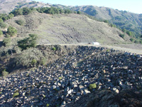 |
| View looking south across Coyote Dam toward slopes of the Diablo Range in Henry Coe State Park. Rip-rap blocks excavated from the area cover Coyote Dam; shale and Cretaceous sandstone cliffs beyond dam |
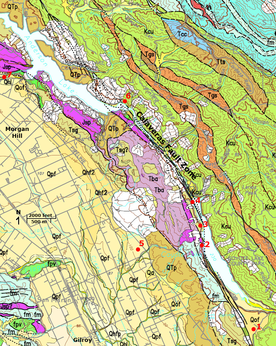
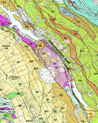
| USGS geologic map of the Coyote-Harvey Bear park area showing stops 1 to 4 |
 |
 |
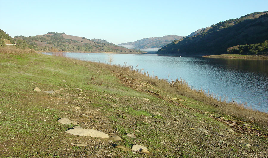
| Gravel deposit along Coyote Lake near park campground. View is north toward the dam |
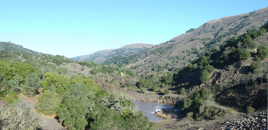
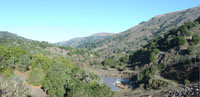
View down Coyote Canyon along the Calaveras Fault zone below Coyote Dam |
 |
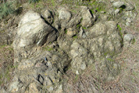 |
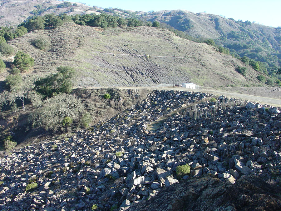
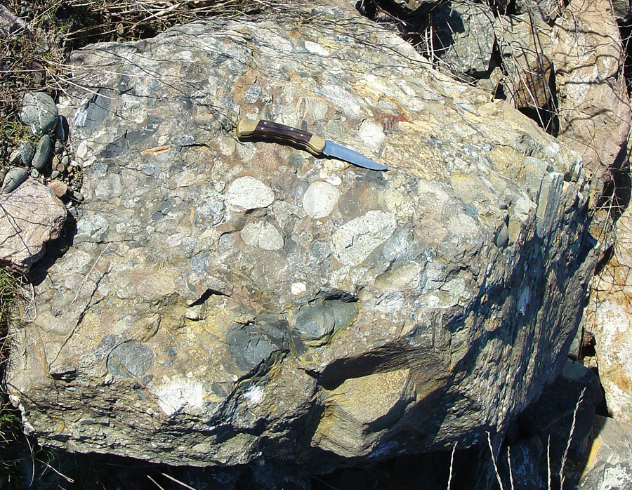
| Block of Cretaceous-age conglomerate on dam. |
Weathering blocks of serpentinite along road cut |
| |
Field-Trip to Coyote Reservoir Dam Area
Stop 1—Entrance Station-Visitor Center: Trip participants should meet at the visitor center and take a few minutes to examine exhibits (they usually have a rattlesnake in a large aquarium on display). It is best to travel as a group of cars directly down to the dam. Note that the road may have pedestrians, bicyclists, and wildlife on the narrow and windy road.
Stop 2—Coyote Reservoir Dam: The dam was constructed in 1934. The earthen-fill dam was constructed directly in the Calaveras Fault Zone. Rocks on the east side of the dam spillway consist of Cretaceous-age marine sandstone and shale (called the Berryessa Formation, part of the Great Valley sequence of Late Mesozoic age). A strand of the Calaveras Fault cuts through in the vicinity of the dam spillway. On the west side of the spillway are bedrock outcrops of conglomerate, also of Cretaceous age. The conglomerate was mined in the reservoir area and used in the construction of the dam. Large blocks of conglomerate and sandstone were used is the rip-rap to cover the downstream side of the dam. On the west side of the dam are bedrock outcrops consisting of serpentinite and silicified greenstone and chert. Another strand of the fault cuts through the dam area beneath the outcrop. The dam survived the strong earthquakes of 1979 and 1984, but the rip-rap did shift downslope as a result of the shaking.
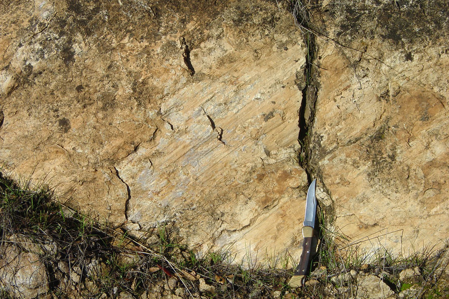
Stop 3—Slickensides along the Calaveras Fault: Slickensides are a polished and striated rock surface produced by friction along a fault. A large panel of slickensides are exposed along Coyote Dam Road near the Calaveras Picnic area (note it is best to examine the outcrop on the return trip of the dam, parking is very limited.) Serpentinite bedrock crops out in several places along the west side of the road. The slickensides reveal the nature of movement along the Calaveras Fault. The scratches are not horizontal, but rise at an oblique angle toward the north (on the west side of the fault plane). This oblique slip helps to explain the gradual uplift of Coyote Ridge on the west side of the fault.
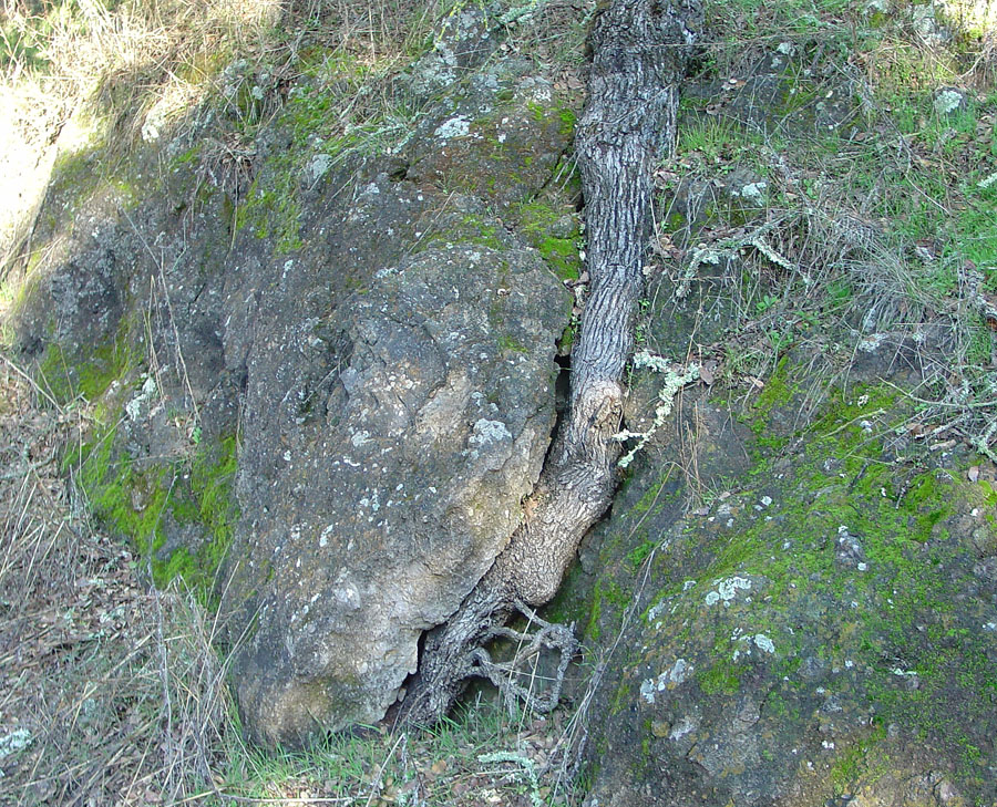
Stop 4—Basalt outcrops along Coyote Reservoir: A large outcrop area at Lookout Point consists of basalt (both massive flow and brecciated tuff). The outcrop area has limited parking and is best to examine on the way out. Find the outcrop with the tree root growing in a large crack. Examine blocks and chunks of the basalt along the shore. Many pieces contain contains spinel peridotite xenoliths (small gray, green to black crystal masses) consisting of zoned plagioclase and olivine (peridote). These xenoliths are interpreted as having been derived from mantle depths (about 40 kilometers). |
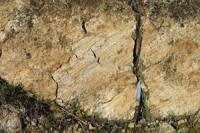 |
| Slickensides reveal oblique slip along part of the Calaveras Fault zone |
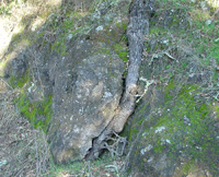 |
| Tree roots splitting volcanic rock exposed along road |
| |
Santa Clara County Parks information
http://www.parkhere.org/portal/site/parks
Park Trails Hotline: (408) 355-2200, press 7, then press 2 for trail closure information.
For general open/close information, please call (408) 225-2147. |
Bryant, W.A., and Cluett, S.E., compilers, 1999, Fault number 54c, Calaveras fault zone,Southern Calaveras section, in Quaternary fault and fold database of the United States: U.S. Geological Survey website, http://earthquakes.usgs.gov/regional/qfaults, accessed 09/07/2012 12:51 PM.
Bakun, W.H, 1980, Seismic activity on the southern Calaveras Fault in central California: Bulletin of the Seismological Society of America August 1980 v. 70 no. 4, p. 1181-1197. Available on-line at: http://bssa.geoscienceworld.org/content/70/4/1181.abstract .
Tikoff, B., 2007, Lithospheric mantle deformation in the Central San Andreas Fault System: Geological Society of America, Abstracts with Programs, v. 39, no. 6, p. 423.; Abstract.
|
|