Geology banner

Chitactac Adams—Uvas—Chesbro County Parks

Field-trip overview: This field trip provides opportunity to examine rocks typical of the southern foothills of the Santa Cruz Mountains. Stop 1 is to examine geologic and archeological features at Chitactac-Adams Heritage County Park. Stop 2 to is to examine the stream valley and rocks exposed in the spillway at Uvas Dam. Stop 3 is to examine rocks and soil exposed along the shore of Uvas Reservoir. Stop 4 is to examine rocks, landscape features, and ecology of the Chesbro Dam area.
Santa Clara County Parks map
Geologic Setting: Compared with other mountain ranges in the United States, the Santa Cruz Mountains are relatively very young. Marine fossils found high in the mountains show that much of the mountainous region was under the ocean as little as 4 to 5 million years ago. Rocks exposed in the eastern foothills mostly consist of ancient oceanic crust (igneous and metamorphic rocks) and sedimentary rocks formed from sediments deposited far offshore in the deep ocean basin to sediments deposited in mid-level to shallow continental shelf environments.

The forces associated with plate tectonics are actively changing the landscape. The Santa Cruz Mountains are rising due to tectonic compressional forces associated with the regional fault system. The San Andreas Fault is the largest and most obvious based on earthquake data and features observable on the landscape. However, other active earthquake faults and older (extinct, dormant, even undiscovered) faults run through the eastern foothills of the Santa Cruz Mountains.

The mountains are rising only slightly faster that weathering and erosion is wearing down the landscape. The foothills are characterized by deep canyons, some roughly follow the trace of fault zones where the bedrock is broken up and more rapidly eroded. Dams installed to manage water supply and control flooding are also traps for sediments moving downstream.

The landscape in the eastern foothills is also host to a variety of plant habitats, with special note to plants associated with serpentinite soils. Serpentinite is one of the common rocks found in the foothills region.
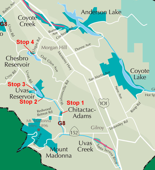
Map of southern Santa Clara County showing the location of selected field-trips stops in the foothills west of Gilroy and Morgan Hill, California. (Map modified from a parks map by the Santa Clara County Parks and Recreation Department.

Stop 1—Chitactac-Adams Heritage County Park: The park is four-acre park site is located on Watsonville Road between Gilroy and Morgan Hill. The park features rock exposures with archeological features (petroglyphs and mortar holes) carved by ancestral Ohlone Indians. The park includes a self-guided interpretive walk and an interpretive shelter focusing on Ohlone Indian culture and the Adams schoolhouse which was sited on this property from the 1850s until 1956.

Take Highway 152 west from Highway 1 (through Gilroy) about 5 miles. Turn right on Watsonville Road (Route G8). Proceed north 1.3 miles. The entrance to Chitactac-Adams Heritage County Park is on the left (west side) just past a bridge over Uvas Creek.

The park is located on along Uvas Creek in an area with massive sandstone outcrops. The sandstone is part of the Vaqueros Sandstone—a sedimentary rock formation consisting of sediments (mostly sand) deposited in shallow marine environments in Late Oligocene to Early Miocene age time. The Vaqueros Sandstone crops out in the California coast ranges and appears in many locations as large rounded, barren, brownish sandstone outcrops, cliffs, and boulder fields. In the subsurface, the Vaqueros Sandstone is the host of many California oil field reservoirs.

In Chitactac-Adams park, the sandstone outcrops along the river create a very scenic setting. It is no wonder that the elevated stream terraces in this area was the location of Indian settlements dating back for many thousands of years. The weathered sandstone has unusual shapes and patterns. Some of the outcrops show classic tafoni-style weathering. Tafoni weathering produces small fist- or head-sized holes and larger cavernous-like features found in granular rock such as sandstone—appearing with tiny pits, rounded entrances and smooth concave walls. They often occur in groups, forming a honeycomb-like form, typically occurring of cliff faces, in overhanging vertical places, on large boulders, and rocky outcrops.and are that can riddle a hillside.

Click on images for larger view
Mortar holes and spiral petroglyph at Chitactac_Adams County Historic Park, Santa Clara County, California
Indian mortar holes and spiral petroglyph carvings
Weathered sandstone outcrop (tafoni weathering)
Tafoni weathering creates unusual-shaped outcrops in the Vaqueros Sandstone outcrops along Uvas Creek

Stop 2—Uvas Reservoir Dam: Uvas Reservoir is located in the foothills below the Santa Cruz Mountains west of the City of Morgan Hill. Upon leaving Chitactac-Adams, turn left on Watsonville Road. Proceed north 2.4 miles and turn left on Uvas Road (continuing on County Route G8). Proceed north on Uvas Road 4.3 miles to roadside parking next to Uvas Dam. This stop is to examining the geologic setting of Uvas Dam. (The word uvas means "grape" in Spanish. Early Spanish settlers found wild grapevines in the area.)

Construction of the dam spillway exposed unusual rocks of the late Mesozoic-age Franciscan Formation: Rocks exposed at the base of the spillway consist of pillow basalts. Pillow basalts are a volcanic rock formation consisting of stacked pillow-shaped pods of basaltic lava formed by lava flowing and rapidly cooling on the surface of a lava flow under water (in the ocean or under a lake). The pillow basalts are nearly perfectly preserved at the base of the dam spillway. Around many of the pillows are rings of gray sedimentary rockdolomitic limestone. The fine-grained sedimentary rock formed from the accumulation of skeletons of calcareous plankton in the crevasses of the basalt pillows. Some of the basalt has small bubbles in it, suggesting that the lava formed in relatively shallow water (without the intense confining pressure in the deep ocean which would have prevented the bubbles from forming). The rock may have been part of an ancient submarine volcanoan atoll or seamount (or guyot) that formed in the ocean near an oceanic spreading center or fault zone, and was carried landward by seafloor spreading and subduction. The volcano survived being subducted but was instead crushed up and exposed in the rising coastal ranges. Similar rocks can be found in the coast ranges throughout California.

Many varieties of rocks can be found around the shores of Uvas Reservoir. These rocks are all derived from units of the Franciscan Formation, the assemblage of rocks that make up the bedrock throughout much of the foothills region east of the San Andreas Fault. Rocks include serpentinite, basalt, greenstone, chert, slate, graywacke sandstone, marble (partially metamorphosed limestone and dolostone), and other rocks formed in the ocean basin and continental margin geologic settings.

Stop 3—Uvas Reservoir Boat Dock and Picnic Area: A parking area Parking is located 0.5 miles north of Uvas Dam (on the right). This stop is to examine limestone & dolomite outcrops, terra cotta soil, and other local rocks in the parking lot vicinity.

The parking area is surrounded by many large boulders that were probably excavated from the reservoir area with the dam was constructed. Most of the boulders consist of partially metamorphosed graywacke sandstone. Graywacke is a variety of sandstone or mudrock generally characterized by its dark color and poorly sorted angular grains including a mix of quartz, feldspar, dark mafic minerals, and tiny rock fragments cemented in a compact, clay-fine matrix. On the shoreline of the small island-like butte in the lake south of the parking lot are exposures of limestone (large blocks). The red soil along the cut in the hillside is terra cotta soil (iron-rich lateritic soil commonly associated with weathering in limestone bedrock). Some of the blocks show karst (or cavern) like weathering caused by dissolution of the limestone.

Stop 4—Chesbro Reservoir: Chesbro Reservoir is located in the foothills east of the Santa Cruz Mountains and west of the City of Morgan Hill. The Chesbro Reservoir was created by the damming of Llagas Creek.From Uvas Dam proceed north about 6 miles on Uvas Road and turn right on Oak Glen Road. Follow Oak Glen Road east about 2.5 miles to the Boat Launch parking area located near Chesbro Dam.

Two brief stops are recommended. One stop is a pull off on the right side (south side) of Oak Glen Road near the intersection of Llagas Road. Outcrops of weathered dark red-layered chert can be seen along road cuts. This site is near the location where Llagas Creek flows into the reservoir. During low water levels the creek is a delightful place to wade to look at the gravel in the creekbed. This next stop is at the boat dock parking area. A short walk along Oak Glen Road leads to a path that the dam and into the valley below. Outcrops along Oak Glen Road and on the north end of the dam consist of serpentinite.

Serpentinite—
is "still" the State rock of California (several years ago there was a political effort to change it because of the rocks association with asbestos hazards; the effort only increased the popularity of the rock). Serpentinite is a metamorphic ultramafic rock consisting almost entirely of serpentine group minerals (such as antigorite and chrysotile). Serpentinite forms from the alteration of mafic silicate materials, such as olivine and pyroxene (rocks, peridotite and pyroxenite) during metamorphism. Accessory chlorite, magnetite, and talc may be present. The original host rock of serpentinite is possibly mantle rock and ocean crustal intrusive igneous rocks exposed (or formed) is spreading center areas along mid ocean ridges; the rock was later altered by exposure to seawater migrating through the ocean bedrock. Because serpentinite is rich in magnesium and other heavy metals, and deficient in other nutrients essential to most plants, the rock weathers to form "serpentinite soils." In California there are many interesting and unusual plants that are found in association with serpentinite soils. One of the indicator plants of serpentinite bedrock (with serpentinite soils) is the occurrence of manzanita, a plant that has shiny red bark, small evergreen, and small white-to-pink flowers in the spring.

Learn more about serpentinite soils and plant adaptations (U.S. Forest Service website).

Learn more about the Santa Clara County Water Districtthe organization that maintains the dams in the county and manages water resources, conservation, and waste-water disposal in the region.

Twin Peaks in the foothills of the Santa Cruz Mountains
View of Twin Peaks along the Watsonville Road near Chitactac-Adams County Historical Park
Spillway below Uvas Dam with pillow basalts exposed.
Pillow basalt exposed at the base of Uvas Reservoir Dam
Uvas Reservoir
View looking northwest from Uvas Reservoir Dam toward the location of Stop 3 at the park picnic area. The linear-shaped valleys basically follow the traces of faults cutting through the Uvas Valley area.
Loma Prieta and Chesbro Reservoir
Loma Prieta, the highest peak in the Santa Cruz Mountains, as seen from Chesbro Reservoir
Chesbro Dam
Chesbro Dam
Serpentinite outcrop near Chesbro Reservoir
Serpentinite near Chesbro Dam with Manzanita forest

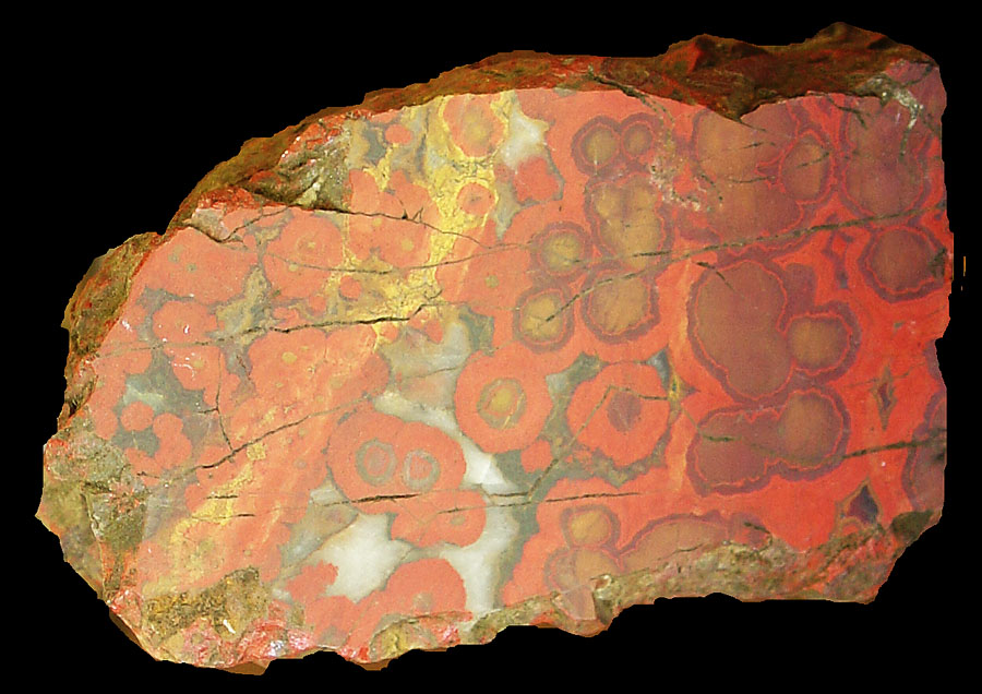
Morgan Hill poppy jasper: The Morgan Hill area is historically famous for its "poppy jasper." Poppy jasper is a varity of "orbicular chert"a hard, metamorphic variety of silica-rich rock (chert) that has ring-like bands or spots of red, orange, yellow, and white. These are imbedded in a matrix of similar chert ranging in color from red, orange, yellow, to black. Several varieties of poppy are found throughout the foothills of the Santa Cruz Mountains. A famous mine locality in Morgan Hill produced a large amount of poppy jasper in the first half of the 20th century. The rock was sought after by lapidary and jewelry craft and much of what is commercially available today came from that mine (long closed to production). Poppy jasper is still reported by local collectors, but getting access to collecting sites is nearly impossible on private land. The orbicular jasper is likely formed by the metasomatic alteration of vesicular volcanic rock. Hot fluids carrying dissolved silica and iron migrating through porous volcanic rock filled in the holes with iron minerals and silica.

Morgan Hill poppy jasper
Selected Reference Information:

Stoffer, P.W. and Messina, P., 2002, Field-Trip Guide to the Southeastern Foothills of the Santa Cruz Mountains In Santa Clara County, California: U.S. Geological Survey Open-File Report 02-121: U.S. Geological Survey Open-File Report 02-121, 29 p. Available online at: http://geopubs.wr.usgs.gov/open-file/of02-121/of02-121.pdf

McLaughlin, R.J., Clark, J.C., Brabb, E.E., Helley, E.J., and Colón, C.J., 2002, Geologic Maps and Structure Sections of the Southwestern Santa Clara Valley and Southern Santa Cruz Mountains, Santa Clara and Santa Cruz Counties, California: U.S. Geological Survey, Miscellaneous Field Studies MF–2373, 8 plate (maps with cross sections) and technical report. Available online at: http://pubs.usgs.gov/mf/2002/2373/

Santa Clara County Parks information
http://www.parkhere.org/portal/site/parks
https://gotbooks.miracosta.edu/fieldtrips/Central_Coast/chitactac_uvas_chesbro.html
8/28/2012