
Field Trip to Anderson Dam and Coyote Creek, |
| Field-trip overview: Anderson County Park is host to a variety of features important to understanding the geology and landscape in Santa Clara County. This field trip involves 3 stops with three short walks (totaling less than 2 miles). Stop 1 is to examine rocks and geologic features exposed in the spillway area. Stop 2 is to take in the view from the dam and hike to examine geology near the boat dock and to a hilltop memorial site. Stop 3 will be to examine rocks exposed along the shoreline on the north side of the dam. Directions: Take the Cochrane Road Exit on Highway 101 near Morgan Hill. Follow Cochrane Road east (toward the dam) for about 2 miles. The Live Oak Picnic Area parking is on the left. Meet in the parking area. A day use parking fee is required for each car. Stops 2 and 3 are inside Anderson County Park; the park entrance is on Cochrane Road just past the dam (and park exit). Instead of driving to stops, it is about a 4-mile round-trip walk: start at the bridge at the live Oak Picnic Area, hike up the Serpentine Trail (past the spillway) to the top of the dam; walk across the dam and follow the trail starting near the boat dock to a trail loop past a sag pond and the hilltop on the south side of the dam. |
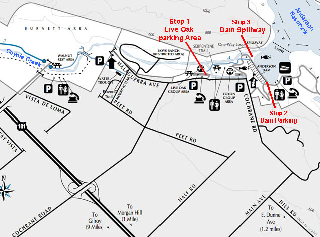 |
| Map of the location of field trip stops in the vicinity of Anderson Dam near Morgan Hill, CA | |
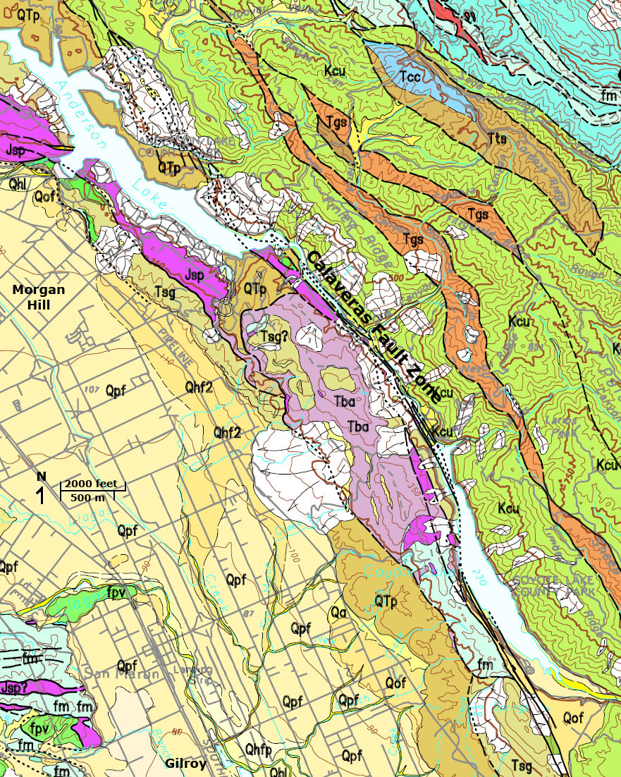
| Geologic Setting: Anderson Lake County Park is the site of Santa Clara County's largest reservoir—it is seven-mile long and when full covers 1,250 acres.
The Anderson Reservoir fills the a canyon drained by Coyote Creek that has its headwaters in Henry Coe State Park region, upstream of Coyote Reservoir. Between Coyote Reservoir (to the south) and Anderson Reservoir (to the north), Coyote Creek follows a linear valley that follows the path of the Calaveras Fault. Over time, the path of Coyote Creek has been "stretched" northward by the strike-slip offset motion of the Calaveras Fault. Anderson Dam was constructed in a water gap that cuts through a long shutter ridge defined by Coyote Ridge (to the south) and Yerba Buena Ridge (to the north along the east side of Highway 101). Anderson Dam was built in 1950 and Coyote Dam (upstream) was built in 1934. Before the dams, Coyote Creek drained into Santa Clara Valley spilling sediments on a broad alluvial fan that spread across the valley around Morgan Hill. At times in the past, Coyote Creek merged with Llagas Creek (draining from the Santa Cruz Mountains) and flowed through marshes and wetlands before merging with the Pajaro River and eventually draining into Monterey Bay. At other times, Coyote Creeks channel shifted and drained northward through a canyon gap before draining into San Francisco Bay. Today the stream is managed to control flooding and to moderate stream flow into a number of percolation ponds (old gravel pits) in the Coyote Valley east of Highway 101(Coyote Valley is the lightly developed region between Morgan Hill and the Santa Teresa Hills near south San Jose. Rocks exposed around Anderson Dam are part of the "Coyote Block"-a fault-bounded mountain-sized mass of rocks consisting of late Mesozoic age rocks: serpentinite (Coast Range Ophiolite), Franciscan Formation mélange (chert, greenstone [metavolcanic rock], and graywacke sandstone), and: late Tertiary volcanic rocks—basalt flows, sills, and dikes (late Miocene to Pliocene) and gravel deposits (Mio-Pliocene Silver Creek Gravels and Plio-Pliocene Silver Creek Gravels). The gravel beds are old river and alluvial fan deposits. They are now steeply dipping and deformed by ongoing active region tectonics uplifting and deforming the Coyote Block. East of Anderson Reservoir the rocks of the Diablo Range around Henry Coe State Park consist of Late Cretaceous and early Tertiary marine sedimentary rocks—shale (slate and mudstone), conglomerate and graywacke sandstone, and other rocks. |
Click on images for a larger view. |
 |
|
| Geologic map of the Morgan Hill region (USGS1) showing Quaternary sediments in Santa Clara Valley and bedrock of Coyote Ridge (west of Anderson and Coyote Reservoirs) and the Diablo Range east of the Calaveras Fault. |
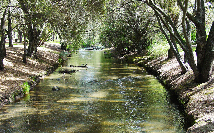
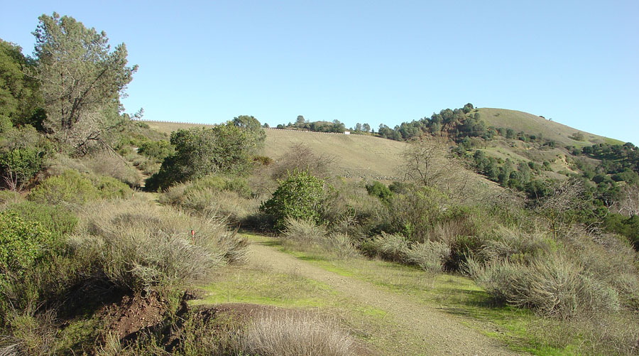
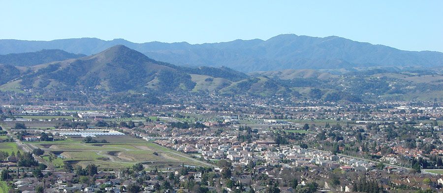
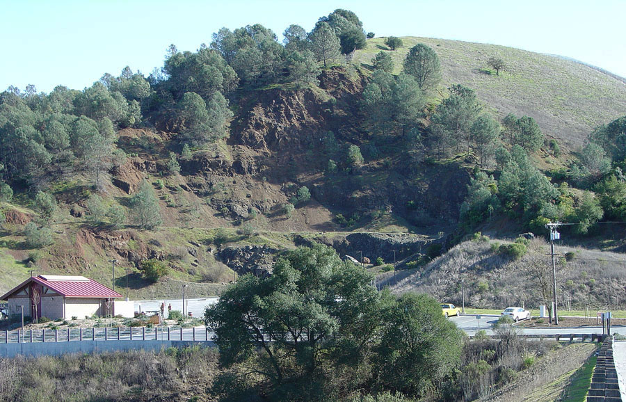
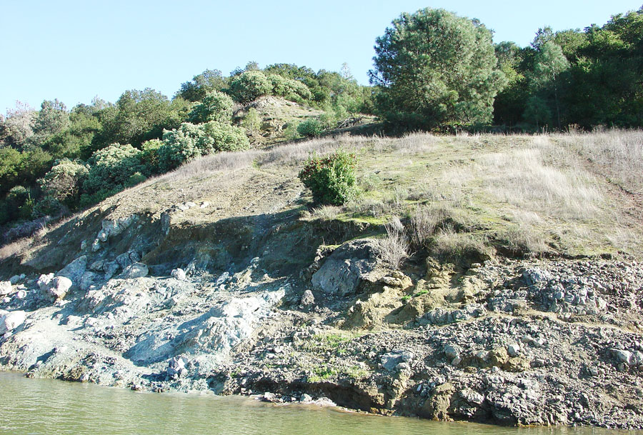
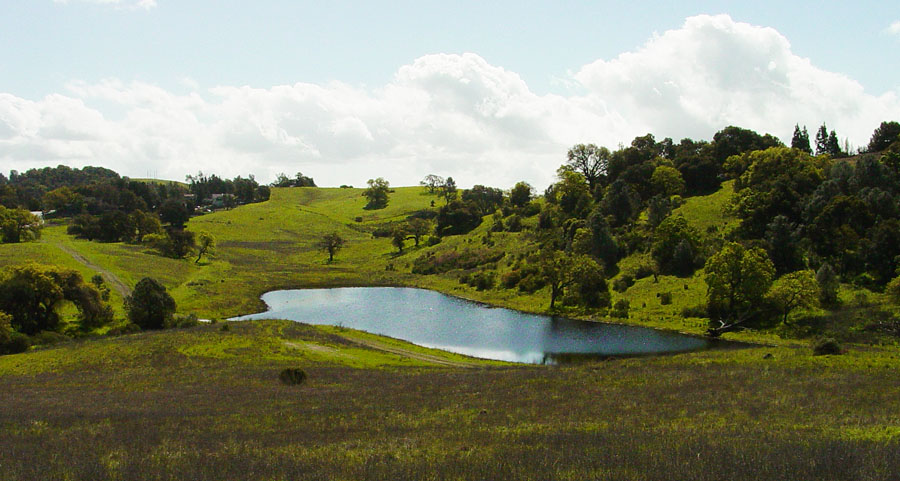
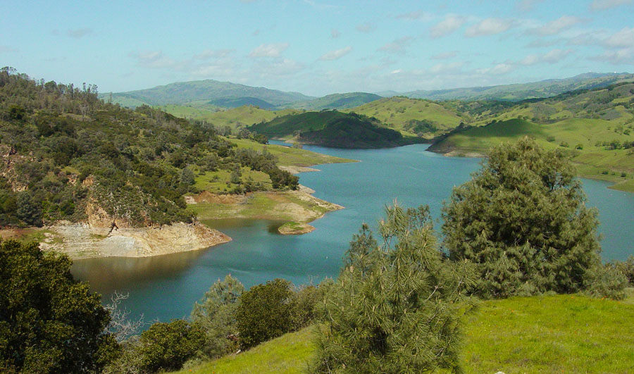
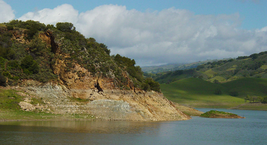
| Stop 1—Coyote Creek at Live Oak Picnic Area: Coyote Creek flows through park land below Anderson Dam. The stream flow is managed to prevent flood damage and to moderate water supply for the Santa Clara County Water District. In the past, this area was an Ohlone Indian settlement area. In the past, the area was a patchwork of stream channels with gravel bars. With flow stabilization, the gavel bars along Coyote Creek are vanishing to vegetation cover. Walk across the picnic area to find the Serpentine Trail. The trail follows the shore of a small oxbow (a pond in an old, abandoned stream channel) and ascends a low hill to the base of the dam spillway. Excavation of the spillway cut has exposed Franciscan mélange—a mix of greenstone (metavolcanic rock) and red ribbon chert. These rocks represent deep ocean basin rocks of late Mesozoic age that were carried by plate-tectonic motion before being crushed onto the California continental margin (where it is exposed today). Continue up to the top of the dam on the Serpentine Trail. Walk south across the Dam to the Boat Dock Parking Area (drivers must park vehicles without trailers on the dam at Stop 2). Stop 2—Boat Dock Parking Area: The unhindered view from the top of Anderson Dam is exceptional—El Toro Peak rises above the Santa Clara Valley near Morgan Hill, and the Sierra Azul Ridge forms the skyline of the southern Santa Cruz Mountains with the high peaks of Loma Prieta and Mt. Umunhum (near south San Jose). Outcrops of greenstone and weathered basaltic volcanic rock are exposed in the high cut next to the Boat Dock Parking Area. On the shore next to the boat dock is a massive outcrop of serpentinite that is bounded on the east a fault juxtaposing graywacke and greenstone. This fault is an extension of a fault that cuts southward parallel to the crest of Coyote Ridge (to the south). Next to the boat ramp is a trail that rises through a hillside shrub forest covered with knob-cone pine and manzanita. The trail leads to a loop trail that provides access to a vista point on the hilltop. In wet seasons, a small pond fills a sag (depression) on the ridge top. The sag may be related to the fault visible next to the serpentinite exposed by the boat dock. The sag pond may be a low area created by a large deep-seated slump associated with ridge-top spreading. The vista point on the hilltop provides a spectacular view of the whole region including the straight valley flooded by the main body of Anderson Reservoir. In this area, the Calaveras Fault runs along the flank of the mountainside east of the reservoir. However, there are numerous faults associated to the fault system crossing the western foothills of the Diablo Range. Fault displacement measurements show that the Calaveras displays measurable creep of as much as 1.5 centimeters per year in the Coyote Reservoir area. The fault has been responsible for several large and damaging earthquakes in historic times. The 1984 Morgan Hill earthquake had a magnitude 6.2. The Coyote Lake earthquake had a magnitude of 5.7. Both earthquakes were along the Calaveras Fault and both resulted in millions of dollars in damage and dozens of injuries (no deaths). Stop 3—Boat Dock Parking Area: a trail follows the shoreline along the north side of the reservoir near the along the lakeshore near the spillway. The trail leads to outcrops of serpentinite and volcanic rocks (calc-silicate rock) that have been heavily altered by hydrothermal activity. Large fissures in the cliffs along the hillslope hint at the ongoing tectonic activity in the area. |
 |
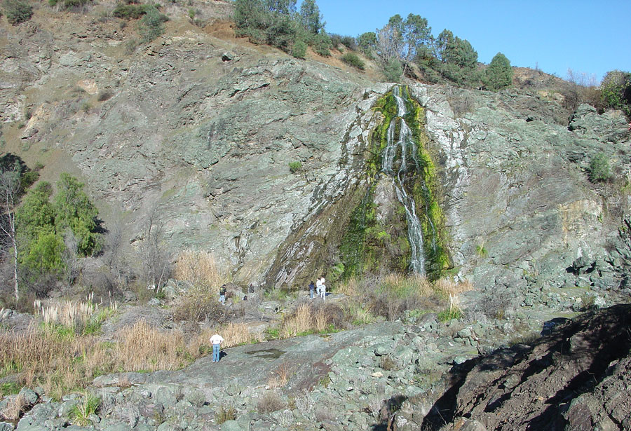 |
| Coyote Creek below dam | Coyote dam spillway cut | |
 |
 |
|
| Santa Clara Valley, El Toro, & Santa Cruz Mountains | ||
| Serpentine Trail and dam | ||
 |
 |
|
| Greenstone and basalt in cut next to the boat-dock parking | Serpentinite next to a fault exposed near the boat dock | |
 |
 |
|
| Sag Pond on hilltop above boat dock parking area | Anderson Reservoir in Calaveras Fault valley | |
 |
 |
|
| Serpentinite and calc-silicate outcrop on north shore. |
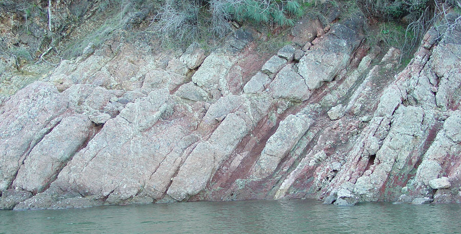
Sandstone, conglomerate, and red shale along shore | |
| In 2009, the Santa Clara County Water District decided to lower water levels in Anderson Reservoir out of concern that the dam may be seismically unstable during a very large (7.25 magnitude) earthquake potentially occurring on the Calaveras Fault (about 2 kilometers east of the dam). Concern is for other large earthquakes occurring on the faults close to the dam that could cause considerable damage. | ||
| Santa Clara County Parks information http://www.parkhere.org/portal/site/parks |
||
1Wentworth, C.M., Blake, M.C., Jr., McLaughlin, R.J., and Graymer, R.W., 1998, Preliminary Geologic Map of the San Jose 30 X 60 Minute Quadrangle, California: A Digital Database: U.S. Geological Survey Open-File Report 98-795, map and technical report are available online at: http://pubs.usgs.gov/of/1998/of98-795/ |
||
9/5/2012