Chapter 5 - Atmospheric Processes and Climate |
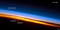
Energy Transfer Through the AtmosphereThe amount of energy coming into the Earth from the Sun is equal to the energy reflected and radiated back into space. The atmosphere, oceans, and land absorb and release energy. Living things also absorb and release energy. Some of the energy stored in organic matter is preserved when it is buried in sediments. Geothermal energy is also a trace of the energy radiated into space. The rate of energy transfer also varies due to cloud cover and ice and snow coverage.Incoming solar radiation involves all wavelengths of the electromagnetic spectrum. Figure 5-3 shows the wavelengths and intensity of solar energy striking the top of the atmosphere and the energy reaching the surface. The atmosphere is transparent to most wavelengths, but part of the solar spectrum are absorbed by certain greenhouse gases in the atmosphere including water vapor, carbon dioxide, ozone, methane, and other gases. Shorter wavelengths (UV and blue light) is diffused in the air—making the sky blue. Longer wavelengths are less diffused—making sunsets and sunrises red (Figure 5-4). Energy that is not reflected back into space is radiated back into space in wavelengths longer than visible light (mostly in the thermal infrared portion of the electromagnetic spectrum). |
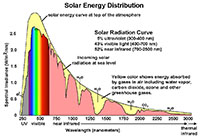 Fig. 5-3. Wavelengths of solar energy transmitted and absorbed by the atmosphere.  Fig. 5-4. Energy transfer through the atmosphere |
Composition of the Atmosphere• Nitrogen (N2) - 78%• Oxygen (O2) - 21% • Argon - 0.9% • Carbon Dioxide (CO2) - 0.036% • Others < 1 % - Neon, Helium, Methane (CH4), Krypton, Hydrogen (H2), traces of other compounds Other trace gases in variable amounts include nitrogen oxides, ozone (O3), sulfur dioxide, hydrocarbons, and more. These gases are released by volcanic eruptions, lightning, wildfires, erosion, and pollutants of many kinds from human activity. Major sources of air pollutants included gases and smoke released by fossil-fuel energy consumption, industrial releases, agriculture, and leaks of refrigerator and air conditioner coolant compounds. |
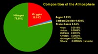 Fig. 5-5. Chemical composition of the atmosphere (major and trace gases) Fig. 5-5. Chemical composition of the atmosphere (major and trace gases) |
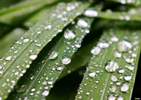
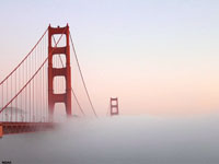
Water Moisture in the Air (Humidity)The amount of water vapor in the air can range from trace amounts up to about 4% by volume. Humidity is a term used to describe the relative amount of water vapor dissolved in the air. In general terms, humid refers to moist air and arid refers to dry air conditions.Warm air can hold more moisture than cold air. As warm, moist air cools, the relative humidity increases. When air has reached the maximum amount or water it can hold it is called saturated - this occurs when clouds form and moisture condenses to for water droplets. As the air continues to cool, microscopic water droplets grow in size and it may start raining! The atmospheric temperature below which water droplets begin to condense is called the dew point. The dew point is the temperature at which moist air reaches 100% saturation. Dew can form on objects and consists of tiny drops of water that form on cool surfaces at night when the atmospheric vapor condenses (such as on grass) (Figure 5-6). Weather reports frequently report the relative humidity. Relative humidity of 100% indicates that the dew point is equal to the current temperature when the air is holding the maximum amount of water vapor (it is saturated), and water vapor will begin to condense into water droplets, forming fog (clouds). Moist air is less dense than dry air. This explains why moist are rises to form clouds. The amount water moisture that air can hold depends on factors including air temperature, air pressure, and the amount and kinds of particulate matter dispersed in the air (see cloud condensing nuclei [CCNs] discussed below). For example, warm, humid air near sea level may be clear clear during warm daylight hours, but as the air temperature drops at night the relative humidity will increase until it reaches the dew point and fog begins to form. Fog is a thick cloud of tiny water droplets suspended in the atmosphere at or near the earth's surface (restricting visibility) (Figure 5-7). As the air continues to cool, the condensing droplets water form mist. When the mist droplets grow large enough to be influenced by gravity, it will fall as precipitation. The dew point is called the frost point when the temperature is below the temperature that water freezes. Below freezing, water moisture in the air will sublimate directly into ice, forming frost, snow, or hail (Figure 5-8). A hygrometer is a device that can measure the humidity in the air. There are many kinds of hygrometers and different ways to measure humidity in the air. Modern hygrometers use sensors that can directly measure the electrical, optical, thermal, and other means to accurately measure water content in the air. Hygrometers are part of any meteorological station, and can be measured with regional radar and satellite sensor data. Hygrometers are important devices for measure moisture in soil. National Weather Service (NOAA) - Relative Humidity Calculator (enter data for current temperature and dew point to determine relative humidity). |
|||
|
The Water CycleThe water cycle involves all processes by which water circulates between the Earth's oceans, atmosphere, and land. It involving precipitation as rain, snow, hail, drainage in streams and rivers, and return to the atmosphere by evaporation and transpiration. The weight of the atmosphere provides the pressure needed to keep water liquid on the surface of the planet. Planets and moons with thin or no atmosphere may have water as ice, but there will be no permanent bodies of liquid water. Ice will sublimate directly to water vapor in a vacuum.The Water Cycle is also called the Hydrologic Cycle (USGS) |
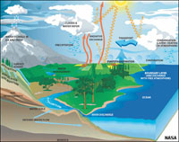 Fig. 5-9. The Water Cycle |
|
Atmospheric (Barometric) PressureA barometer is an instrument measuring atmospheric pressure, used especially in forecasting the weather and determining altitude (Figure 5-10).Air pressure on the planet is directly related to the mass of the air column above at any location under the influence of gravity: Pressure = Force/Area. Atmospheric air pressure is reported as average air pressure measured at standard sea level. Reported barometric air pressure at elevations above sea level are adjusted to be equivalent to air pressure measured at sea level at locations closest to where measurements are taken. How Air Pressure Is ReportedBarometric units most used to describe atmospheric pressure includes atmospheres, millibars, and PSI (pound-per-square-inch).The weight of ONE ATMOSPHERE (Earth's atmosphere above us) is equal to the weight of the Earth's average air pressure at standard sea level. One atmosphere (on Earth, on average) is equivalent to:• 14.7 pounds-per-square-inch (psi) - this might mean something when you add air to you car's tires. The average weight of one Earth atmosphere is now commonly reported as 1013.25 millibars (mb). |
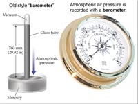 Fig. 5-10. Barometers |
Atmospheric Pressure Drops With Increasing Altitude (Elevation)Elevation and air pressure have an inverse relationship - air pressure decreases with increasing elevation (Figure 5-11). At an elevation of about 18,000 feet you would be above about half of the atmosphere. That, of course, depends on changing weather conditions! An common altimeter is a type of barometer that measures air pressure to report elevation, but altimeters must be adjusted to match local weather conditions.What is the difference between altitude and elevation?If you are flying an airplane, you need to know this! Technically, altitude is the vertical distance from the Earth surface (land or water) to an object (such as an airplane). Elevation is a the vertical distance between a location on the ground and global sea level. |
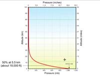 Fig. 5-11. Atmospheric pressure decreases with altitude on a curve. |
Can you feel changes in Atmospheric Pressure?The answer is a most definite yes! As you go up in elevation, air pressure trapped within your ears is not equalized with the air pressure outside, so your ears tend to occasionally pop as you climb in altitude, as your ear ducts release air when you swallow. Older people commonly complain about bone and joint pain when a storm is approaching and air pressure starts falling.The opposite is true when you go down in elevation, such as on an airplane descending from high altitude. Anyone who has frequently flown can tell you about crying children complaining ear aches because their ears have not readjusted to air pressures at low elevations. |
Density of Warm Air vs. Cool AirAs air is heated it expands (moving atoms apart). This reduces the density of air in unconfined space. As a result warm air rises. Conversely, as air cools, it condenses (moving atoms together) and increases it's density in unconfined space. As a result cold air sinks. Because the atmosphere is unconfined, dense cool air will sink and flow to displace warm air in another location (Figure 5-12).Density of Moist Air vs. Dry AirAir saturated with water vapor is less dense than dry air. As a result, moist air will rise relative to dry air if air temperatures and pressures are the same. |
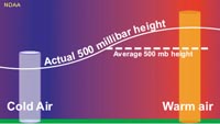 Fig. 5-12. Differences in air pressure at different levels in the atmosphere drive the movement of air. |
Atmospheric ConvectionConvection is the circulation of fluid due to density differences. Atmospheric convection works like a pot of boiling soup, warm fluid rising (in middle) and cool fluid falling (on sides). A rising storm thunderhead is an example of atmospheric convection. Warm moist air rises, expands, releases energy as clouds form. After releasing its heat and moisture, the cooled air sinks, displacing warm air below (Figure 5-13). |
 Fig. 5-13. Atmospheric convection. |
Air Pressure Gradients and Air Pressure Systems• Surface winds blow from high to low pressure - this is called a pressure gradient—displayed as lines of equal barometric pressure on a weather map (Figure 5-14).An air mass is a body of air with a relative horizontally uniform temperature, humidity, and pressure: • High pressure systems have dry conditions with sinking air masses. • Low pressure systems have wetter conditions with rising air masses. |
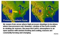 Fig. 5-14. Air pressure gradients and air pressure systems. |
Types of Air Masses and How They FormAn air mass is a large body of air with relatively uniform temperature, humidity, and pressure. Air masses move with the global atmospheric system and can change as the move over landmasses and oceans, picking up or loosing warmth and moisture as they move.
As air masses move they change to match the attributes of the next region. For instance, if a polar (or Arctic) air mass moves south over the North American continent it will become warmer and dryer (becoming a temperate-continental air mass; see example in Figure 5-15). If it moves east over the Atlantic Ocean it may become warmer and pick up moisture and become a temperate-maritime air mass. When a maritime air mass moves over a large landmass it can loose its moisture, heat up, and become a continental air mass. Air masses can move rapidly (if air pressure gradients are high). Air masses can control the weather for a relatively long periods ranging from days to months. They can also stagnate in one region causing long periods or rain or drought. Tropical storms and hurricanes can form in association with tropical-maritime air masses. Most weather occurs along around air masses at boundaries called fronts (discussed below). |
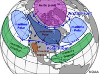 Fig. 5-15. Origin of air masses affecting North America's weather. Air masses move as air pressure gradients change over time. Fig. 5-15. Origin of air masses affecting North America's weather. Air masses move as air pressure gradients change over time. |
| A Year in Weather (2013) NASA YouTube animation- a global mercator map showing storm systems around the world for a year starting in January, 2013. Note the tropical cyclones (typhoons) in the Eastern Pacific, the weather patterns in the Intertropical Convergence Zone, and the Antarctic circumpolar region. |
Dust, Aerosols, and Cloud Condensation Nuclei (CCNs)Cloud condensation nuclei (also known as cloud seeds) are small particles typically 0.2 µm, or 1/100th the size of a cloud droplet on which water vapor condenses. CCNs are aerosols, an aerosol is a colloidal suspension of microscopic particles dispersed in air or gas. The aerosols can be a combination of solid particles and liquid compounds (liquid water or organic residues). |
 Fig. 5-16. Dust from desert regions is a major source of CCNs. See Atmospheric aerosol/dust video (NASA) Globe version (NASA)  Fig. 5-17. Natural CCN aerosols released by plants produce the haze of the Smoky Mountains region of the Appalachian Mountains. |
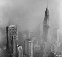 Fig. 5-18. Smog in NYC in the 1970s. Air pollution from human activity is an increasing source of CCNs in the atmosphere. Smoke from manufacturing, vehicles (particularly diesel-burning trucks), coal-burning power plants, and construction dust are significant sources. Efforts to regulate CCNs have helped reduce smog in the US, but what about China? |
| NASA Atmospheric Aerosols on a globe (YouTube animation) |
How does air pressure relate to weather?Increasing high pressure (above 1000 millibars) corresponds with clear, sunny weather.Decreasing pressure (below 1000 millibars) corresponds with cloudy, rainy weather. |
GOES 5 satellite - Atmospheric Winds NASA YouTube video |
|||
|
||||
Weather |
Weather is the state of the atmosphere at any place and time in regards to conditions: sunshine, heat, dryness, cloud cover, wind, precipitation (rain, sleet, snow, hail), etc.
CloudsClouds form when the invisible water vapor in the air condenses into visible water droplets or ice crystals.The dew point is when the relative humidity reaches 100%. The base of a cloud marks the boundary where relative humidity has reached saturation. Cloud tops can rise until they encounter warmer air in the stratosphere. There they stop rising and spread out forming anvil-shaped thunderheads shapes (Figure 5-19). 4 general types of clouds (there are many sub-types) Cirro-form: high level, wispy - fair weather clouds if ice crystals, typically above 20,000 ft (6000 m) Cumulo-form: low to high level cotton-like puffy clouds with flat base at 100% humidity level, can rise to 60,000 feet. Nimbo-form: rain clouds (low to mid level) - clouds typical thicken and lower as precipitation begins. Strato-form. uniform flat cloud layer at any level, forms fog at the surface (coastal marine layer an example) Names of clouds can include combinations of forms as they change. For instance, a small, puffy white cumulus cloud can build up and become an altocumulus cloud, before rising even further to become a cumulonimbus (thunderstorm) that can develop a high anvil-shaped top as the rising moist air at top the cloud encounters the stratosphere and can't rise any higher. Figure 5-20 illustrates common forms of clouds. Also see Types of Clouds (NOAA National Weather Services - Image gallery of clouds and cloud-related phenomena). |
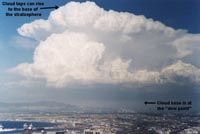 Fig. 5-19. Cloud base and tops of a thunderstorm (a cumulonimbus cloud). 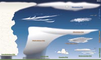 Fig. 5-20. Common types of clouds. |
Lightning and ThunderLightning is giant spark, or series of sparks (electrical discharges), that leap through the air. What causes lightning is complicated, and various theories apply. Areas of positive and negative charges can build up within the same thunderstorm cloud (Figure 5-23). The formation of precipitation (starting with cloud-condensing nuclei [CCNs] to the growing droplets that become rain drops, snow, sleet, and hail) all have surface area that are growing or diminishing as they move upward or downward through a cloud. Changes in surface area of droplets and ice crystals, and the frictional interaction of particles create the negative or positive charges and as condensation or evaporation takes place. Some researchers suggest that heavier, growing precipitation particles carry negative charges to the lower part of clouds as they descend with down-drafts. Updrafts may transport positive charges from near the ground upward through the cloud. Lightning is associated with thunderstorms, but they are also known to occur in association with the clouds associated with volcanic eruptions, hurricanes, tornadoes, forest fires, snow storms, and even discharges from the ground during earthquakes. The power or intensity of lightning varies with the volume of atmosphere hosting electrostatic charges and the distance lightning travels. A typical lightning stroke only lasts about 0.2 seconds. However, a typical lightning bolt can generate up to one billion volts, and they average between 5,000 to 20,000 amps of electrical current (as much as 200,000 amps have been measured - enough to briefly power a small city!). Lighting can heat the air to temperatures around 15,000 to 60,000 degrees Fahrenheit (or much higher). This causes the air to rapidly expand, creating shock waves we hear as thunder. Up close, thunder form a nearby lightning strike sounds as a sharp clap-like high frequency crackle and initial boom, followed by an extended low-frequency rumble as sound wave arrive at different times from farther distant parts of the lightning’s path (higher frequency sounds are absorbed as they travel over longer distances through the air). Thunder can be heard for distances of 25 miles or more under the right conditions. |
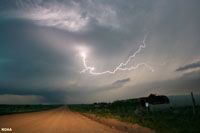 Figure 5-21. Intra-cloud lightning. 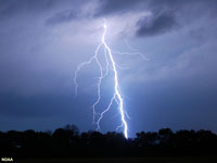 Figure 5-22. Sky-to-ground lightning with leader bands. 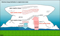 Figure 5-23. Lightning charges (positive and negative) can build up in different parts of a cloud relating to updrafts and down-drafts, and the changing character of precipitation within a cloud. Figure 5-23. Lightning charges (positive and negative) can build up in different parts of a cloud relating to updrafts and down-drafts, and the changing character of precipitation within a cloud. |
How far away was that lightning strike?After you see a flash of lightning start counting seconds. For every 5 seconds the lightning bolt is one mile away. It is advised to take shelter immediately if the sound is less than 5 seconds! |
Weather FrontsA weather front is a boundary separating two masses of air of different densities (Figure 5-24). Fronts are classified as to which type of air mass (cold or warm) is replacing the other.A cold front forms along the leading edge of a cold air mass displacing a warmer (less dense) air mass. Cold fronts are typically narrow bands of showers and thunderstorm and are most commonly associated with severe weather condition. A warm front is the leading edge of a warmer air mass replacing (riding up and over) a colder air mass. If the front is essentially not moving (i.e. the air masses are not moving) it is called a stationary front. Warm fronts typically have a gentle slope so the air rising along the frontal surface is gradual. This configurations results in widespread stratus (strato-form) cloud layers with precipitation near the rear of the frontal boundary. Warm fronts typically quite extensive, and can create typically gray skies and dismal weather—an all too common occurrence in parts of the Midwest and Northeastern United States as slow-moving warm fronts stall over the regions. This can happen any time of year. It reflects that warm, moist air is flowing above cooler air down below, creating the gray stratus cloud layer in-between. Colliding air masses can have both warm fronts. For instance, when a warm, moist air mass (such a maritime-tropical air mass) encounters a cold, dry air mass (such a polar continental air mass), both warm fronts and cold fronts can form as air rotates around a center of low pressure (as illustrated in the lower graphic of Figure 5-24). This rotation is driven by the Coriolis effect (discussed below). |
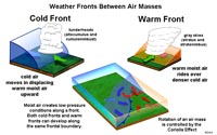 Fig. 5-24. Weather fronts between air masses: cold fronts and warm fronts. |
How do you say which way is the wind blowing?We name wind direction based on which direction it is coming from (from high pressure to low pressure). For instance, if the wind is moving off the Pacific Ocean directly onto the land in California we call it a west wind, or to clarify, out of the west. The direction of wind is named for the direction it is coming from, not in the direction that it is moving towards. |
Weather and ClimatesWeather is localized atmospheric conditions in the short term (described in terms of minute, hours, or possibly weeks).Climate is the prevailing weather conditions in an area in general or over a long period (years, decades, etc.). Weather is typically constantly changing as air masses move across a region. A most common question on a long-distance phone call is: "How is the weather out there?" The answer can typically be "it's sunny," "it's cold," "it's snowing," "or "it's raining cats and dogs," or any other description of the prevailing atmospheric at any time in a location. Climates are controlled by both geographic factors and regional weather patterns. Different regions (climates) typically have seasonal cycles. For instance, the Eastern United States typically has 4 seasons and have frequent weather fronts between polar air masses from Canada and tropical air masses from the Gulf and Atlantic regions. In contrast, California typically has 2 seasons, summers are dry and winters have short rainy periods. Patterns in weather repeat each year and are typically consistent and predictable with seasons of the year. Examples include monsoons in India and the US Desert Southwest, Hurricane season in the tropics, etc. Figure 5-25 illustrates how California's weather and climate is influenced by regional geography and prevailing weather conditions. History shows that climates change. The time spans for changes can range in cycles ranging from years and decades to centuries, or thousands of years. Droughts can start an last for years. Desertification (such as what is happening in Africa) has been progressing for centuries. Parts of the world experienced Mini-Ice Age conditions between the 13th and 19th centuries. Climate change has impacted civilizations throughout recorded history. A classic example is illustrated in the history of the Chaco Culture in the US Desert Southwest (Figure 5-26). See more climate cycle times and events in history on NOAA's Paleoclimatology website). |
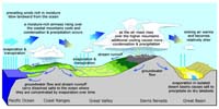 Fig. 5-25. California's weather and climate is influenced by regional geography and prevailing weather conditions. 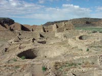 Fig. 5-26. Chaco Canyon in New Mexico was at the center of a regional 13th century society impacted by climate change. Fig. 5-26. Chaco Canyon in New Mexico was at the center of a regional 13th century society impacted by climate change. |
|
|
||
Climate VariabilityCalifornia's history of droughts illustrates climate variability (Figure 5-27). Climate not only vary on a seasonal and annual basis, but there are larger scale fluctuations that impact different regions of the world. One is the El Niño/Southern Oscillation (ENSO) (discussed in Chapter 16). Because the atmosphere is an open system, changes in one region can affect other surrounding regions. Regions that may experience dry conditions for decades may suddenly have a severe rain period, or regions that are typically wet can sustain drought. Likewise, regional temperature average can swing through cyclic periods. Some of these changes can be progressive and represent long term changes. For instance, during the last ice age, Southern California was very wet, and large lakes filled many of the basins between mountain ranges. By about 5,000 years ago, the lakes dried up as the climate changed, then they returned as wet conditions returned for periods of time. The last major drying period was about 500 years ago, as recorded by the evidence of Indian village sites associated with fishing on the shores of SoCal lakes that now are mostly barren desert. See a website on Climate Variability (NASA). |
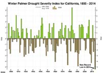 Fig. 5-27. California's cycles of drought and wet periods is an example of climate variability. |
Effects Of Uneven Heating Of Earth By the SunThe amount of energy Earth receives from the Sun is not evenly distributed (Figure 5-28). More solar energy (per unit area) is delivered to the equator than near the poles.• The equatorial regions are warmer than the poles because direct sunlight is concentrated and little is reflected. • In polar regions, light strikes the earth at an angle; it is diffuse and much of it is reflected back into space. • The seasonal variations (winter and summer) also affect the distribution of heating of the planet. This imbalance between the solar heating in the tropics and at the polar regions is a major factor in atmospheric movement on Earth and other planets with atmospheres. |
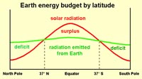 Fig. 5-28. Solar energy budget by latitude |
The Coriolis Effect on Atmospheric and Ocean Circulation Systems |
| Heat from insolation (short for INcoming SOLar radiATION) is the driving force behind the fluid motion of the atmosphere and the oceans. However, the patterns of motion are also influenced by the forces created by the rotation of the Earth on its axis. Any mass moving in a rotating system experiences a force (the Coriolis force) the acts perpendicular to the direction of motion and to the axis of rotation. Because air has mass, air currents maintain momentum when moving from a location of high pressure to low pressure. However, because the Earth is rotating, the rotation causes a right-turn deflection in the Northern Hemisphere and a left-turn deflection in the Southern Hemisphere (Figure 5-29). The Coriolis effect influences all moving objects, especially ones moving over large distances (such as intercontinental ballistic missiles). The Coriolis effect causes objects or moving masses of air to: • Change direction—not speed. • Maximum Coriolis effect occurs at poles. • No Coriolis effect occurs at equator. |
|
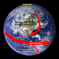 Fig. 5-29. The Coriolis effect is cause by the rotation of the Earth on its axis. This rotation causes air masses moving from high to low pressure to deflect. Fig. 5-29. The Coriolis effect is cause by the rotation of the Earth on its axis. This rotation causes air masses moving from high to low pressure to deflect. |
Earth's Atmospheric Circulation SystemThe global atmospheric circulation system influences the movement of air masses in general wind belts that move air in rotating masses within zones around the planet. These wind belts seem relatively stable when viewed in a long-term view (decades). However, fluctuations may occur on seasonal or annual basis. The wind belts are influenced by the Coriolis effect and large-scale convection patterns in the atmosphere (Figure 5-30).These relatively stationary wind belts impact the surface of the oceans, creating currents that circulate waters in the oceans. Studies of the atmosphere have show that their are 3 major atmospheric systems called circulation cells (Figures 5-30 and 5-31). |
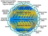 Fig. 5-30. Global wind circulation patterns impact regional climates and drive the large current systems in the global ocean circulation system. |
Circulation Cells in Earth's AtmosphereThree major circulation cells move air, heat, and moisture through the atmosphere between the equatorial regions to the polar regions. These cells are constantly changing due to regional air pressure changes under the influence of the Coriolis effect.Hadley cells (0° to 30° N and S of equator) • Responsible for the Trade Winds: They blow NE in N. Hemisphere and SE in S. Hemisphere. Ferrel cells (30° to 60° N and S of equator) • Responsible for the Prevailing Westerlies in both hemispheres. Polar cells (60° to 90° N and S) • Responsible for the Polar Easterlies in both hemispheres. |
 Fig. 5-31. Hadley, Ferrel, and Polar circulation cells in Earth's atmosphere redistribute convectional heat. |
What is the Jet Stream?A jet stream is a narrow, variable band of very strong winds in the upper troposphere. They are predominantly westerly air currents encircling the globe several miles above the Earth. There are typically two or three jet streams in each of the northern and southern hemispheres. These high-speed wind currents often move at speeds exceeding 250 miles (400 km) per hour at altitudes of 6 to 9 miles (10 to 15 km). Jet streams are influenced by moving air masses and the Coriolis effect causing them to meander and sometime split. See the location of the jet streams in Figures 5-31 and 5-32. |
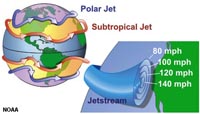 Fig. 5-32. Polar and Subtropical jet streams |
Equatorial Doldrums and Inter-Tropical Convergence Zone (ITCZ)The equatorial doldrums are associated with the inter-tropical convergence zone (ITCZ) the region that circles the Earth near the equator, where the trade winds of the Northern and Southern Hemispheres converge (Figure 5-33).The doldrums are located within the Intertropical convergence zone near the equator. The doldrums are: • Area of low atmospheric pressure with lots of rain. • Located on equator where there is least influence of the Coriolis effect. • Low wind area with calms, sudden storms, and light unpredictable winds Seasonal shifts in the location of the ITCZ affects rainfall in many equatorial regions, resulting in the wet and dry seasons of the tropics rather than the cold and warm seasons of higher latitudes. The ITCZ moves north during winter in the northern hemisphere and south in the summer. |
 Fig. 5-33. The doldrums are the belt of clouds along inter-tropical convergence zone. This belt of clouds (with lots of rain) migrates north and south across the equator with the seasons. |
The Tropical Easterlies (Trade Winds)During the age of sailing ships, ship captains learned take advantage of the prevailing wind belts to cross the oceans. Two belts of trade winds encircle the Earth, blowing from the tropical high-pressure belts (Hadley Cells) to the low-pressure zone of the equatorial inter-tropical convergence zone. The tropical easterly wind belts near the equatorial region are also called the Trade Winds. Trade winds blow steadily toward the equator from the northeast in the Northern Hemisphere, or the southeast in the Southern Hemisphere (see Figures 5-30 and 5-31). |
Horse LatitudesThe horse latitudes are belts of calm air and sea occurring in both the northern and southern hemispheres between the trade winds and the westerlies (roughly 30-38 degrees north and south of the equator). Horse latitudes separate the Hadley and Ferrel Cells. It is a region also called the subtropical high—a belt of very dry because of high pressure, little rain. Horse latitudes roughly correspond with major desert regions of the world. The horse latitudes got it name from historic legends describe ships becoming becalmed when crossing the horse latitudes and running out of water and unable to re supply. Sailors would throw horses on the ships overboard. |
 Fig. 5-34. Location of the horse latitudes (subtropical highs). |
Weather data animations:Global atmospheric circulation video - High Speed Weather—Satellite Infrared of the entire globe (NASA data)See animations current data from NASA Global Geostationary Weather Satellite (GOES weather satellite). Current San Diego Weather Radar (accuweather.com) - this website provides current weather radar conditions for local, state, regional, and national scales with looping animations. |
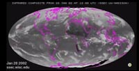 Fig. 5-35. Weather satellite data animation. |
The Coriolis Effect Influences SuperstormsLarge rotating storms are called hurricanes (near North America), typhoons (near Southeast Asia) and cyclones (in the Indian Ocean). All are the same, caused by warm moist winds being drawn to the center of low pressure near the center of the storm (called the eye in well developed storms). North of the equator the Coriolis effect causes low-atmospheric pressure to rotate counterclockwise, but south of the equator they rotate in a clockwise direction. The lower the air pressure in the eye of the storm, the greater the wind speed and rotation. Note on the map in Figure 5-36 that there are no hurricanes along the equator or near the poles. These are regions where the Coriolis effect is not a significant force in deflecting storm winds to cause rotation.Superstorms not only can cause major wind damage and flooding, but can erode and redeposit vast quantities of sediments, both offshore and onshore, heavily impacting impacting both communities and ecosystems. |
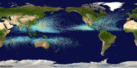 Fig.5-36. World map showing historic paths of hurricanes, typhoons, and cyclones. The large storms are the same (different names for different regions); storm rotation is influenced by the Coriolis effect. |
Tropical Cyclones, Hurricanes, and TyphoonsTropical cyclones are large rotating air masses with low atmospheric pressure (Figures 5-37 and 5-38).Tropical cyclones are called hurricanes in the Atlantic Ocean or in the Pacific near North or South America, and Hawaii). Tropical cyclones are called typhoons in the Western Pacific Ocean region. They are simply called cyclones in the Indian Ocean region. Northern Hemisphere Example: • Storms Intensify over warm water (>77 degrees F); warm water provides water vapor. • Water vapor provides fuel for storm in the form of latent heat energy as water vapor condenses. • Storms die over land and cool water. • High winds, tornadoes occur near storm center and along feeder bands. • Sea level can rise in front of storm called a storm surge. • Classified by maximum sustained wind speed (see rating storms below). • Hurricanes and other storms rotate counterclockwise in the Northern Hemisphere because of the Coriolis effect. |
 Fig. 5-37. Hurricane Andrew (1992) was for a time a Category 5 hurricane with sustained winds of 175 mph (280 km/hr). |
Ratings Storms (By Maximum Sustained Wind Speed)• Tropical depression (<38 mph)• Tropical storm (between 38 and 74 mph) • Tropical cyclone (>74 mph) Saffir-Simpson Scale: 5 categories of hurricane intensity based upon wind speed (see NOAA website) • Category 1 is from 74 to 96 mph. • Category 2 is from 96 to 110 mph. • Category 3 is from 111 to 130 mph - level considered a "superstorm" (Katrina, 2005). • Category 4 is from 130 to 155 mph (examples: Andrew, 1992, Hugo, 1989). • Category 5 is >155 mph (Camille, 1969). Naming storms: Alphabetical lists of names are assigned each year to storms that develop in each of the ocean basins. Names of notoriously damaging storms are retired to remind people of their impacts and legacy. The term superstorm is used to describe any powerful and destructive storm that affects a large area or region. Tropical storms and cyclones can be superstorm, but other massive storms in temperate and polar regions can be become superstorms. Nor'easters are extra-tropical superstorms that typically impact the Northeastern United States in the fall and winter season, causing massive amounts of snowfall and coastal flooding. |
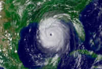 Fig. 5-38. The eye of a hurricane is the center of low pressure. Hurricane Katrina (2005) shown here, was the most costly and destructive hurricane disaster in US history, killing more than 1,800 people. |
Severe WeatherSevere weather conditions can occur anywhere, but some area are more susceptible to severe weather than others due to regional geography and climate factors. Severe weather includes strong convective thunderstorms, winter storms (severe cold, blizzards, and ice storms), damaging wind storms and tornadoes, flooding, dust storms, extreme heat, and firestorms.Atmospheric scientists are constantly monitoring weather conditions to make predictions of potential severe weather conditions (and potential disasters), using ground-based weather observations combined with remote sensing data (satellite, airplane, Doppler radar, etc.). These are combined with historic weather data in order to make weather predictions. The Federal government has been recording statistics of deaths and property damage due to weather-related activity for many decades. Floods and droughts (with associated famines) have remained the most deadly disasters worldwide. In the United States, extreme heat events and floods remain the numbers 1 and 2 killers (Figure 5-39). Tornadoes are number 3, but they are perhaps the most terrifying because of their unpredictable occurrence and suddenly destructive behavior. TornadoesTornadoes are mobile funnel-shaped rotating vortexes of wind that form and advance beneath large storm systems (Figure 5-40). Tornadoes vary considerably in their destructive power—how strong their winds are, how long they are in contact with the land surface, and the distance they travel. Storm systems can often produce multiple tornadoes (called a tornado outbreak). A single storm cell can sometimes produce multiple tornadoes simultaneously. The 2011 Super Outbreak (April 25-28) produced 392 "confirmed" tornado in 21 states (between Texas and New York) with four rated as F5 tornado on the Fugita tornado intensity scale (see table below).
Figure 5-41 shows a tornado probability map of a typical day (June 23) in the United States based of historical tornado data; data for each day of the year shows that tornado activity in the country varies significantly from season to season and from one region to another. The central Great Plains region is commonly called Tornado Alley because it statistically experiences the greatest number of tornadoes in any given year, but weather and climate data show that trends are changing (as well as better recording of data). The Great Plains and Midwest typically experience clashing air masses—cool and dry air masses that move east from the Rocky Mountains and Canada collide with warm, moist air masses moving north from the Gulf of Mexico and Atlantic regions. When conditions are right, large thunderstorms that display intense convection and rotation can generate vortexes that descend as funnel clouds—these become tornadoes when the start to impact the surface. DroughtDrought is a prolonged period of abnormally low rainfall. Drought conditions commonly lead to other disastrous weather conditions including dust storms, heat waves, and firestorms, all of which can be catastrophic. The worst droughts in US history occurred in the 1930s and 1950s, resulting in Dust Bowl conditions throughout the Great Plains and Midwest that lead to severe economic damage and social upheaval and migrations. Drought periods have alternated with serious flooding in intervening years. Figure 5-27 (above) shows the cyclic nature of droughts and flooding periods for the State of California. During recent droughts, devastating firestorms have ravaged communities throughout the regions around San Diego, Los Angeles, Santa Barbara, San Francisco, and throughout the Sierra Nevada region—as urban development has spread into areas where vegetation is naturally apt to burn on a frequent basis during drought conditions (Figure 5-42). Conversely, flood conditions during wet El Niño years can potentially be more catastrophic to California than drought. Recent investigations into the impact of a California mega-flood event that happened in California in the winter of 1871-1872 suggest that if were a similar event were to happen today it could potentially be the most destructive natural disaster to impact the United States—possibly causing nearly three times as much damage than a great earthquake in the region.To see information about current and forecasts of regional storm activity see: NOAA/National Weather Service Storm Prediction Center |
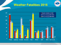 Fig. 5-39. NOAA severe weather statistics averages for the United States. 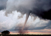 Fig. 5-40. this F3 tornado occurred on May 3, 1993 in Oklahoma. 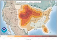 Fig. 5-41. Tornado probability map of the United States showing the likelihood of a tornado occur based on historic data for June 23 of any year. 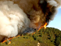 Fig. 5-42. A flame front of a firestorm near Santa Barbara in 2007. 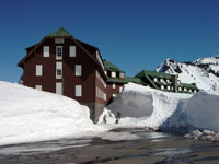 Fig. 5-43. Massive snow accumulation can be anticipated in places like Crater Lake, OR. However, giant winter storms can have long lasting effects, not just the cold and ice, but the shutting down of regional infrastructure and economies. |
||||||||||||||||||||||||
What is the Greenhouse Effect?The greenhouse effect is the trapping of the sun's warmth in a Earth’s lower atmosphere. This happens because lower atmosphere due to the greater transparency of the atmosphere to visible radiation from the Sun than to thermal infrared radiation emitted from the surface (Figure 5-44). A glass green house will let sunlight in, but captures some of the thermal energy within the enclosed interior. A greenhouse gas is any gas that absorbs and emits energy in the Thermal infrared range. Primary greenhouse gases in earth's atmosphere include: water vapor (H2O), carbon dioxide (CO2), methane (CH4), nitrous oxide (N2O), and ozone (O3). |
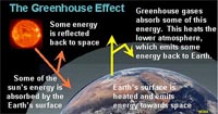 Fig. 5-44. The greenhouse effect is enhanced by the presence of greenhouse gazes in the atmosphere. |
Global Warming and Earth's GreenhouseEarth is currently growing warmer at an alarming rate! The weather records compiled from around the world indicated that there has been a significant rise in global temperatures over the past century. This rise in temperature is linked to the increasing amount of carbon dioxide and other greenhouse gases accumulating in the atmosphere (Figure 5-45). The rise in carbon dioxide and other greenhouse gases is a result of consumption of fossil fuels, deforestation, and other human impacts since the start of the Industrial Revolution in the 19th century.Figure 5-46 compares the rise in atmospheric CO2 to the decrease in the ratio of stable carbon isotopes 13C/12C. The cyclic patterns in the graph is a result of the annual growth of plants in the northern hemisphere. During the summer months plant growth consumes CO2, reducing CO2 concentrations in the air. In the winter months the decay of organic matter increases CO2 concentrations. The overall trend shows that atmospheric concentrations of CO2 is increasing. The cyclic pattern in the 13C/12C also reflects the plant-growth cycles, but also shows the dilution of 13C concentrations by the influx of carbon from fossil fuels. Carbon in fossil fuels (coal and oil) are enriched in12C. There are many knowns and unknowns about the future of global warming. Highlights include sea-level rise, climate changes, changes in storm intensity and regional precipitation, changes in air and ocean chemistry (acidification), and other impacts on humanity and natural ecosystems.
|
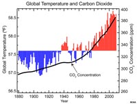 Fig. 5-45. Changes in global temperature with the rise in atmospheric CO2. 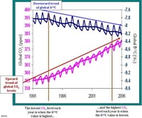 Fig. 5-46. Changes in atmospheric 13C/12C concentrations. |
Atmospheres on Other PlanetsThe processes affecting Earth's atmosphere can also be seen on other planets. For instance, Jupiter, a planet about 318 times more massive than Earth has similar atmospheric circulation zones and bands (Figure 5-47). On Jupiter, the bright zones are regions of rising cloud tops, and the dark zones are regions of sinking air. Bright spots on Jupiter are massive cyclones (some are larger than planet Earth!). Jupiter's upper atmosphere is composed of hydrogen, helium, and has clouds composed of ammonia ice crystals (NH3). |
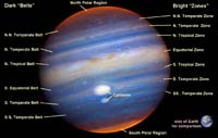 Fig. 5-47. Wind belts on Jupiter. |
| Chapter 5 quiz questions |
