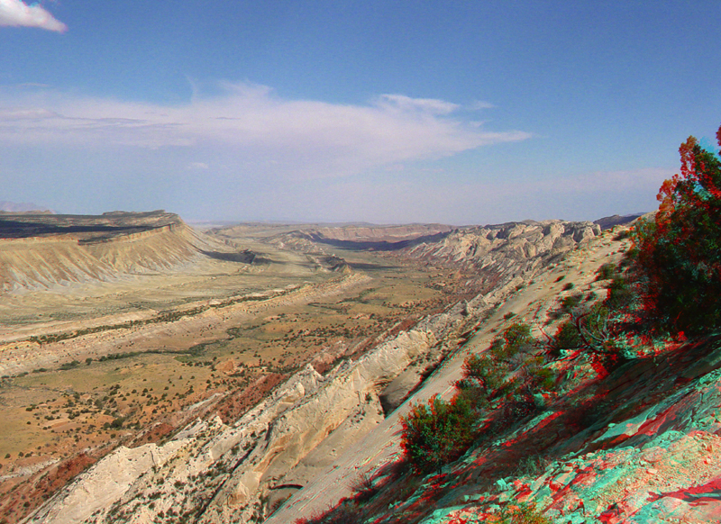
| Perhaps the most amazing view in the region is this scene looking south
from the Strike Valley Overlook along a great, warping arc of strata exposed in the
Waterpocket Fold. The scene encompasses about a 2 kilometer thick section
of sedimentary rocks representing about 130 million years
of earth history in the region. The oldest sedimentary rocks on the right (the
Navajo Sandstone) represent a great blanket of desert dunes that extended
across the region in Early Jurassic time. Beneath the valley of Halls Creek is a sequence of Jurassic-age sedimentary units that includes the Carmel (red, above the Navajo), Entrada, Curtis and Summerville Formations. The Morrison Formation (Late Jurassic) and Dakota Sandstone (Late Cretaceous) are exposed along the ridge in the center of the valley. These formations reflect the changes in Jurassic time when the great dune
fields gave way to coastal tidal flats, floodplains, swamps, and shallow, marginal marine environments associated with inland seas.
The Mancos Shale (gray layer on slope on left) represents the formation of a great inland Western Interior
Seaway that existed in the region through much of Late Cretaceous time. The sandstone rimrock of Tarantula Mesa on the left is Mesaverde Formation. The Mesaverde Formation consists of materials deposited in nearshore and coastal environmental settings as the Western Interior Seaway gradually withdrew from the region near the end of the Late Cretaceous period. The great upwarp of the Waterpocket Monocline is a prominent Laramide structural fold that formed in Early Tertiary time (See Morris and others, 2000; click here to see a NPS stratigraphic section with interpretation of units).
This seaway finally withdrew from the region at the close of Cretaceous time. |